Forum Replies Created
-
AuthorPosts
-
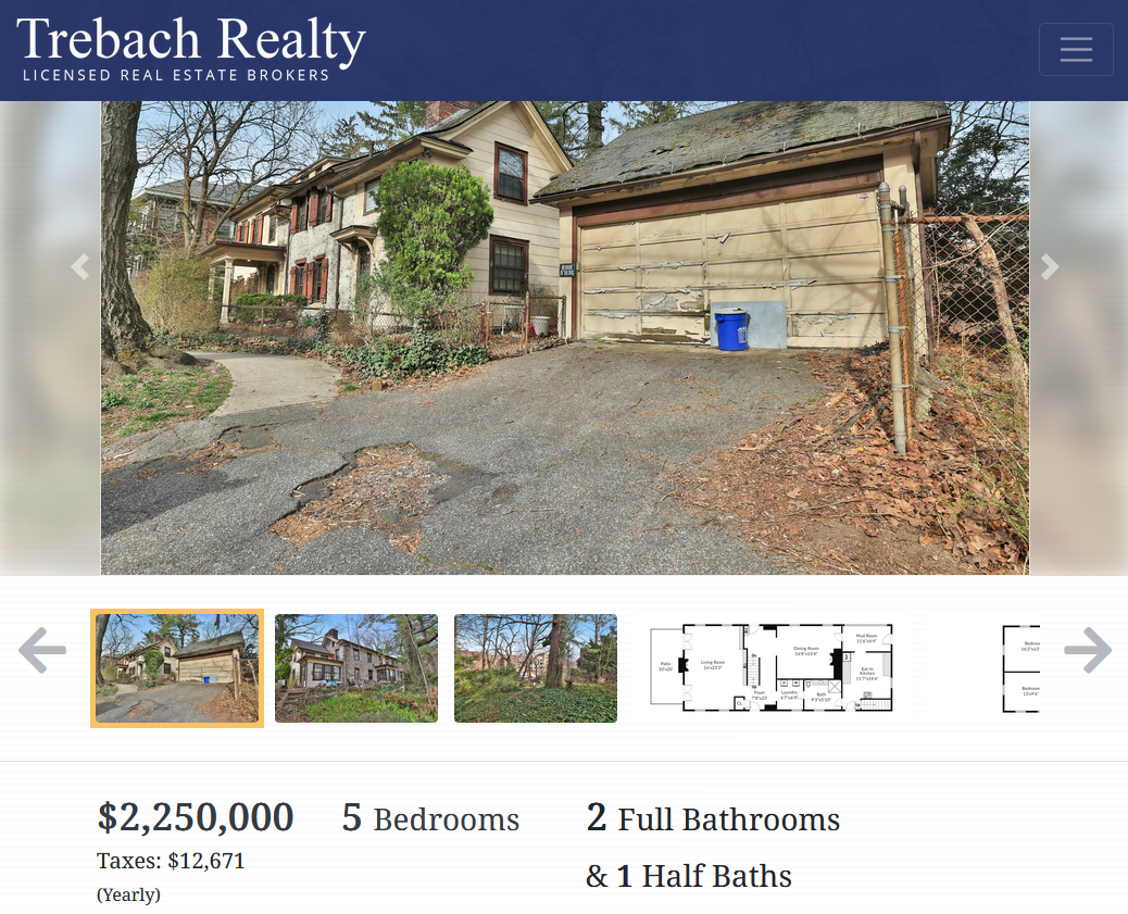
I am reviving this old thread because the Hadley House is for sale! $2.25 million will get you a city landmark that is older than the United States (although the exact date of its construction is a real mystery). Here is the deep dive I wrote about the house: https://kingsbridgehistoricalsociety.org/the-hadley-house-at-5122-post-road/
Well, that’s one heck of a coincidence! Pretty amazing.
Stephanie asked about where the baseball games may have been played at Spuyten Duyvil. That’s a good question since the area is so hilly with very little level ground for a field. I think the answer can be found in this memoir by J.B. James, who grew up in the neighborhood in the late 1800s:
There was a baseball club at Riverdale and one at Spuyten Duyvil, and matches were played between them, usually on a level piece of land at the Spuyten Duyvil belonging to the Cox Estate. Here also were held athletic games, which were quite important events socially.
Cox was a business associate of the Johnsons who operated the iron foundry and stove works on the Spuyten Duyvil Creek. The Cox estate was just to the west of Edgehill Church in today’s lower Henry Hudson Park.
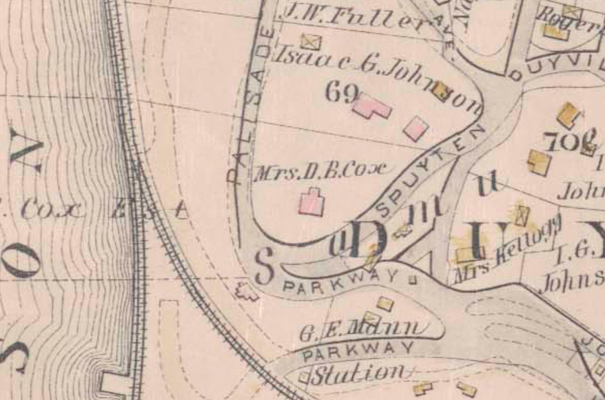
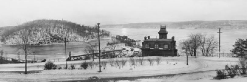
Our neighborhood panorama exhibit, which opens on April 25th at Edgehill, features this image of the Cox estate house and the field behind it that is almost certainly the “level piece of land” described in the memoir. Great backdrop for a ball game.
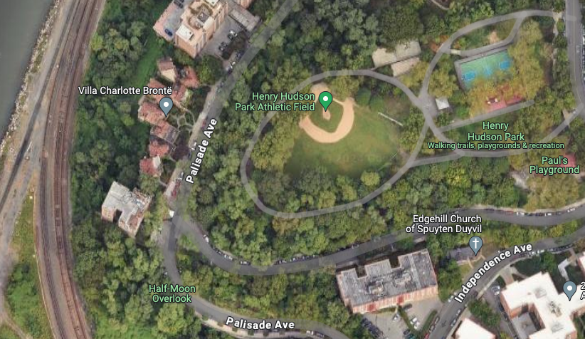
What’s there today? A baseball field! Going by the date of the 1865 New Times article, today’s little leaguers are carrying on a 160 year old tradition of playing baseball at that location.
Fascinating to learn about the women behind the scenes that made those gorgeous windows. Thanks for sharing and great photos.
March 3, 2024 at 8:28 am in reply to: The Russian Mission under construction, from the top down, 50 years ago #3957I had no idea you could construct a building that way.
Interesting that there was a school inside the complex. I wonder if that is still there.
John McMenimon, a teacher in Yonkers, recently reached out to me with regard to the family of Stephen Simmons. John thought to contact the Episcopal Diocese of New York to learn if free Black people living in Yonkers were buried at St. John’s Cemetery. St. John’s Church in Yonkers was the local Anglican church for our area during the colonial period and beyond. He found Stephen Simmons listed as having died on December 24, 1874 at the age of 84. The cause of death was consumption (on the last row below):
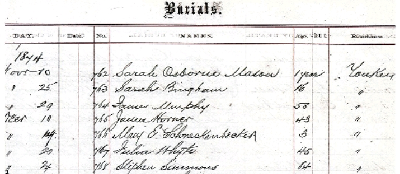
From some of the other names on the documents, it is clear that many Kingsbridge/Riverdale residents were interred at St. John’s Cemetery, which is in a historic district in Yonkers (across the street from the Alexander Smith Carpet Mills) in the Saw Mill River valley.
St. John’s Church goes back to 1752. That is where the Van Cortlandts and other local families went to church. The pastor there during the American Revolution, Luke Babcock, was a loyalist who was imprisoned by Patriot revolutionaries. He died shortly after being released and was interred in the Van Cortlandt Family Burial Vault in Van Cortlandt Park.
January 13, 2024 at 1:52 pm in reply to: Isaac Low – Delegate to 1st Continental Congress and local resident #3856Thanks for the compliment. I would probably publicize it more but ever since I upgraded our server, it lost a lot of its functionality.
I think you are right about being your tenure as a member. 1956, wow!
I’m not sure if you are looking for:
1) where railroad stations were located in today’s South Yonkers before the trains entered Van Cortlandt Park or
2) where railroad stations were located in our area before the creation of Van Cortlandt Park (when this part of The Bronx was known as South Yonkers)?
Either way, here are three maps that might be helpful:
Map of the Bronx. [including part of Yonkers, Mount Vernon, and New Rochelle].
Map of the Bronx [including Yonkers, Mount Vernon, and New Rochelle].
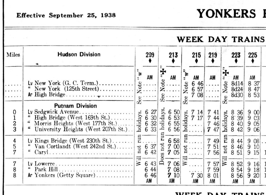
The railroad changed ownership many times even before they finished building it and went by many different names so that’s why it is referred to as the “New York and Northern” above. Below are timetables for the Putnam Division of the New York Central. Here is the main branch (1942):
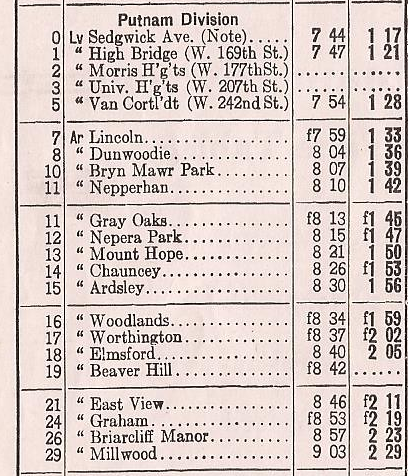
And here are the stops on the spur to Getty Square in Yonkers:
You can still see remnants of railroad infrastructure in several parts of Yonkers.
January 9, 2024 at 12:15 pm in reply to: Isaac Low – Delegate to 1st Continental Congress and local resident #3846Good questions. You sent me down a bit of a rabbit hole this morning. Just a little background for anyone else that might be reading:
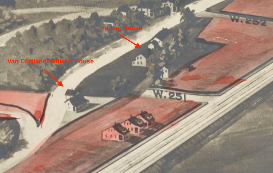
The Hadley House is a house that still stands at 5122 Post Road in Riverdale just north of W. 251st Street. It is a city landmark and I wrote a deep dive article about it here. But the first of your questions relates to another historic house that stood just to the south of the Hadley House on the old Albany Post Road during the Revolution. That building was known as the Van Cortlandt Miller’s House and it is no longer standing. I’ve labeled both houses on the map below (the Hadley House was rented by Isaac Green during the Revolution).
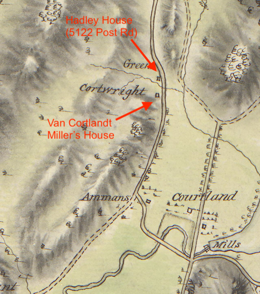
In the above map you can see that the Van Cortlandt Miller’s House was occupied by someone named Cortwright in 1781. But the Van Cortlandts owned the house and property around it. There were a number of people families named Cartwright, Cortwright, or Kortright in our area. Perhaps one of them was the miller at the Van Cortlandt mills during the Revolution and was living in the Miller’s House at the time. The Miller’s House, if it hadn’t been torn down, would have been on the dead-end section of Post Road South of W. 251st. That’s a bit off the beaten path so here’s a photo of that street (view looking south with Van Cortlandt Park’s Parade Ground on the left and the Horace Mann campus in the distance).
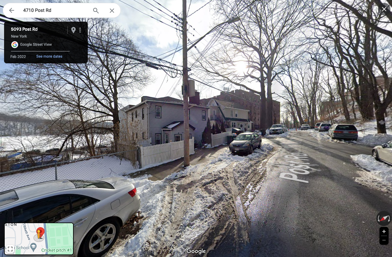
The two houses on the left are modern constructions and not historic. I am not sure when the Van Cortlandt Miller’s House was torn down but it was still standing about 100 years ago. The Van Cortlandts owned most of the property between Broadway and the Post Road since the colonial period and sold it at auction in 1919. The NYPL has a great aerial view of the land that was to be sold at that auction:
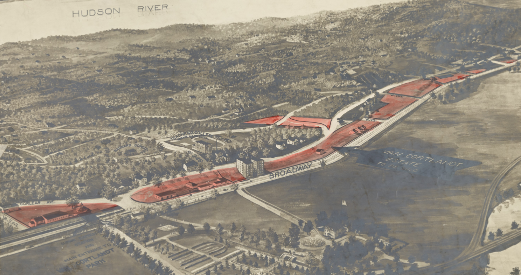
Zooming in on the area around W. 251st and Post Road….
The Miller’s House looks like a Dutch-style farmhouse with a nice porch. Here’s a photo of it in the collections of the Museum of the City of New York:

Perhaps the Miller’s House was knocked down to make way for the apartment building that now stands at the corner of W. 251st and Post Road.
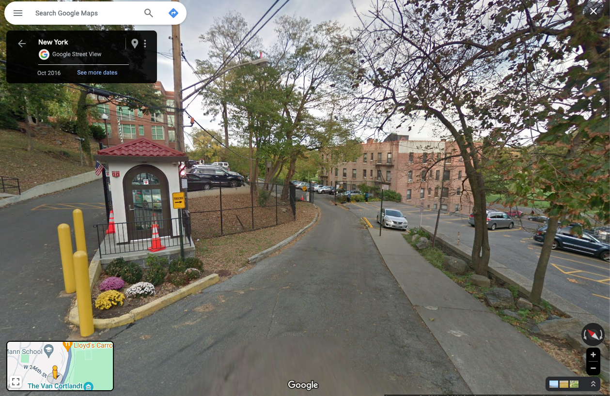
The second part of your question about the section of Post Road that is now part of the Horace Mann campus is interesting. Here’s a photo of Post Road and W. 246th Street. I always assumed that the road leading into the campus to the left of the security booth was the old Post Road.
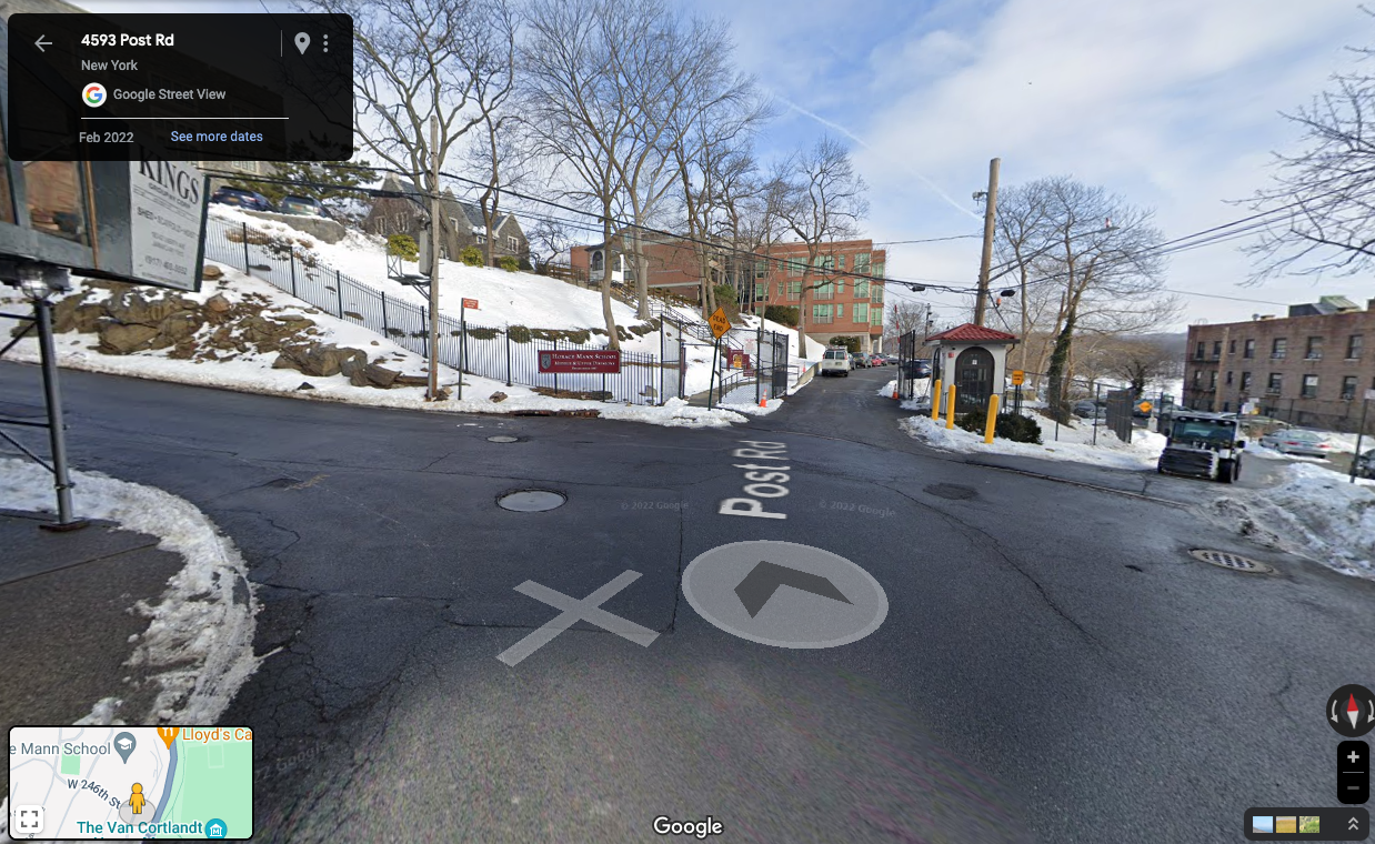
But there’s a lower road just to the right of the security booth. I’ve never paid attention to it before:
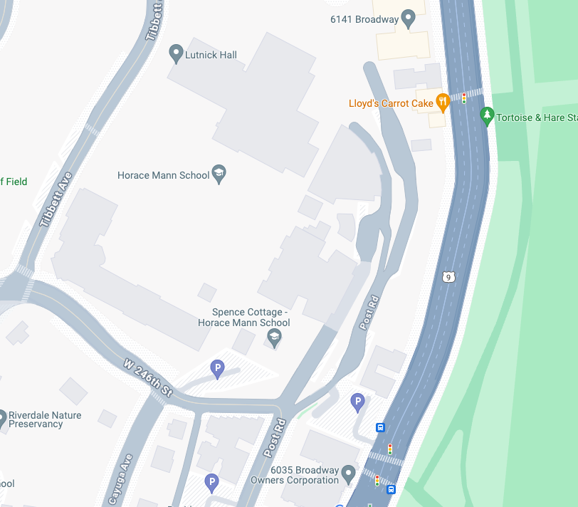
Looking at the Google Map below, it would appear this lower road is actually the Post Road.
The same NYPL Van Cortlandt Estate Sale aerial view depicted that area in 1919:
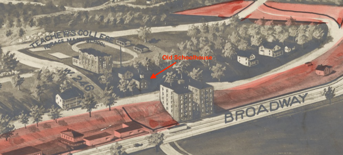
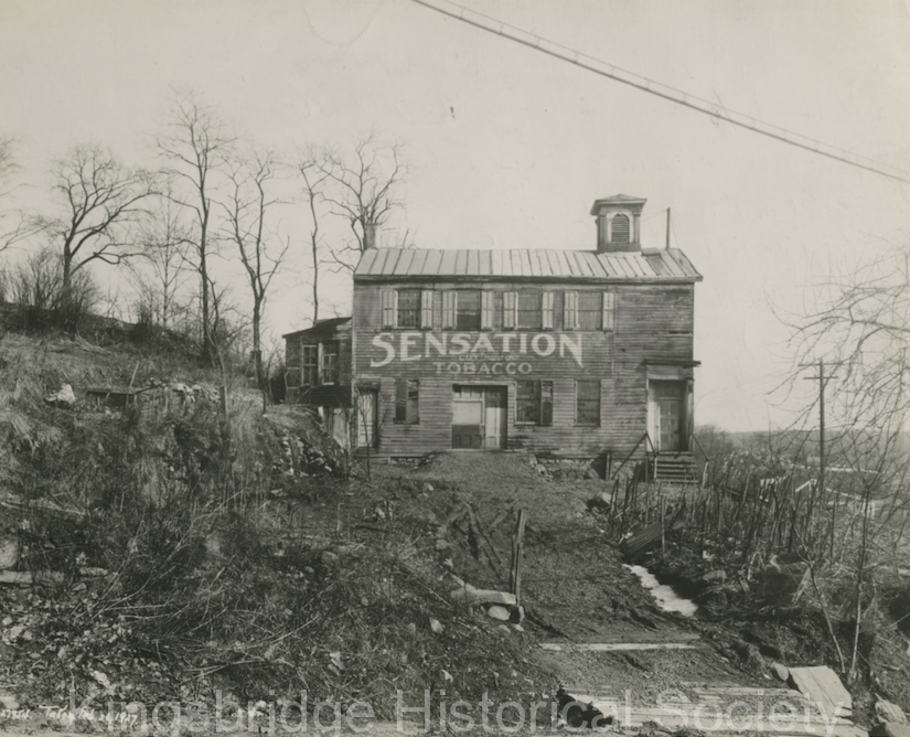
I labeled the old Mosholu schoolhouse because we have an image of it in our collection (ca. 1927):
 January 8, 2024 at 5:42 pm in reply to: Isaac Low – Delegate to 1st Continental Congress and local resident #3843
Thanks Dan. I labeled and colored one of those other maps for you (two versions):
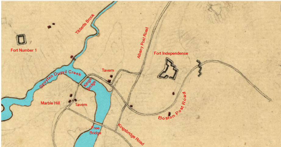
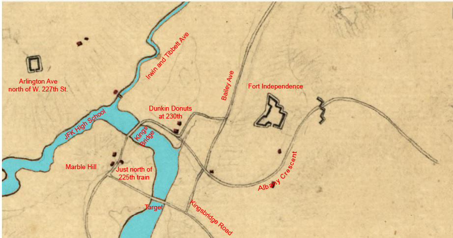
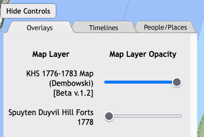
You may want to check out the link here to a map that I made. It is not exactly working as intended because my programming code is outdated but you can adjust the slider buttons that look like this below in order to see different layers:
Back in the early days of the Society a member made this map, which is pretty great.
January 5, 2024 at 2:32 pm in reply to: Isaac Low – Delegate to 1st Continental Congress and local resident #3840It has been a weird fixation of mine to figure out what all those unlabled building markers represent on Revolutionary era maps–to find out who they belonged to…
One thing that is helpful (obviously) are maps where the inhabitants are labeled like this one:
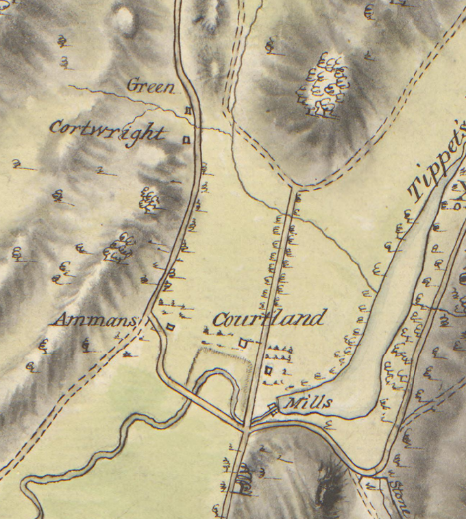
But the above map is from 1781 and many homes were destroyed or abandoned by then so many of the residents’ names are missing. The maps from earlier show more home sites than this one. Another document that’s helpful is the 1775 militia roll for the South Yonkers company. It is a long list of names of local people and you search for them in land deeds, recorded wills, and other documents in archives to figure out where they lived. You can also use the 1790 census and later maps to get some clues.
January 5, 2024 at 11:24 am in reply to: Isaac Low – Delegate to 1st Continental Congress and local resident #3838I agree, Tom, that we cannot know for sure that Isaac Low’s house was where I initially suggested (in today’s Van Cortlandt Park). I picked that spot because the testimony stated that Low’s barn was near James van Cortlandt’s house, which is the Van Cortlandt House Museum. But another reason why I think Low’s house could have been there is that the structures I identified on the map don’t appear on Revolutionary era maps from 1781, indicating that they stood at the war’s outset, but could have been destroyed or dismantled later during the war. Although unless something else definitive turns up, your guess is as good as mine.
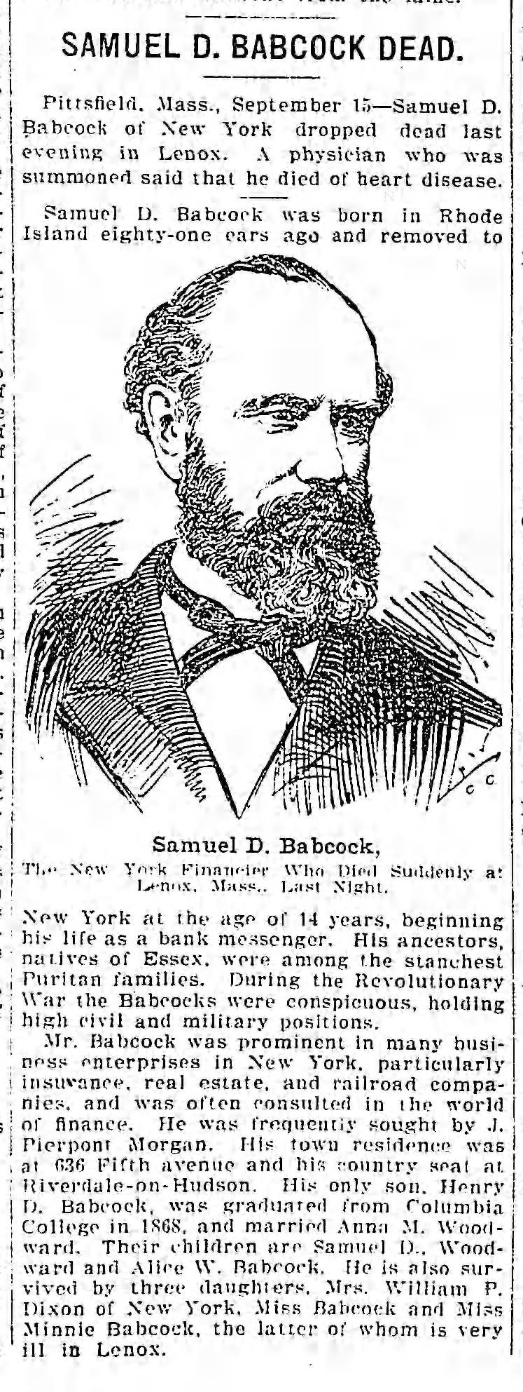
December 17, 2023 at 9:05 am in reply to: Minnie Babcock, a Victorian house, and social life in “Riverdale-on-Hudson” #3825I did manage to find an obit for Samuel D. Babcock, which mentions Minnie at the bottom (9/15/1902 Brooklyn Daily Eagle):
 I have a few more images from the scrap book. In 1878 Minnie went to the American premiere of Bizet’s “Carmen” at the New York Academy of Music.
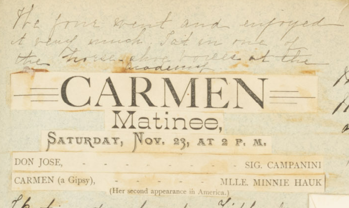
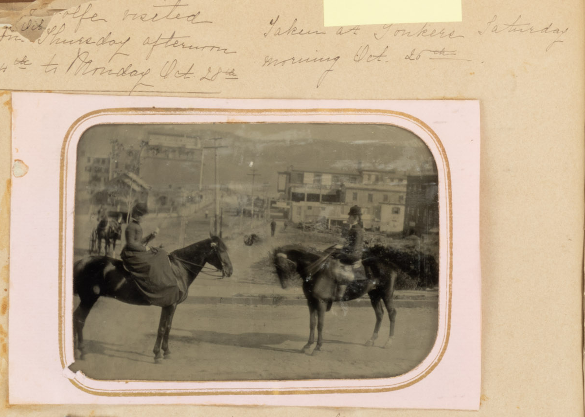
Here is a photo “taken at Yonkers Saturday morning Oct. 25th.” On another day she wrote about “a lovely horseback ride in the morning to Port Chester and back.”
Correction: I was just told that the Columbia Florist was NOT in the same location in the old photo, but rather a couple of stores down.
I think it has to be a property marker. It looks very similar to the one Tom posted for the Delafield property. And I can’t think of anything else it could be.
Good idea. Here is a link to the superimposed map (use the blue bar in the upper right corner to adjust the opacity of the 1872 map and zoom on the top left): https://kingsbridgehistoricalsociety.org/images/stone%20marker%20map/openlayers.html
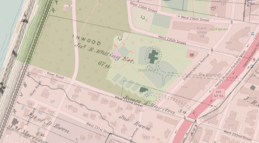
I think it could very well be a property marker of some kind but it is not lot 54 in Hudson Park as shown in the map Tom found, which was apparently north of 236th Street. This marker on W. 232nd seems to be on the property boundary between Judge Whiting’s property and James Hayden’s property.
We discussed Whiting a little in this thread: https://kingsbridgehistoricalsociety.org/forums/topic/the-hudson-river-and-railroad-illustrated/
It sure is an interesting question. It is difficult to find a history that does not refer to the Philipses as the lords of Philipsburg Manor. Here, here, here, and here are all examples of histories referring to them as “lords.” But I have never seen a colonial period document addressing him as “Lord Philipse” or referring to him that way. Nor does it seem that the Philpses referred to themselves as “lords.” These clippings are from colonial New York newspaper ads:
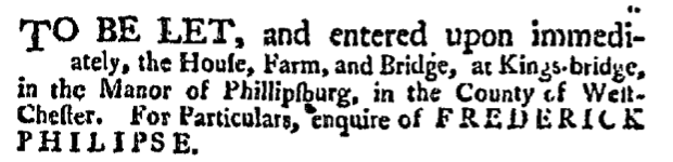
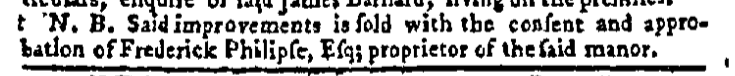

You see him as an “Esq.” or a “proprietor” but not a “lord.” Philipses held many government positions as well and they were never referred to as “lords” in any of the minutes.
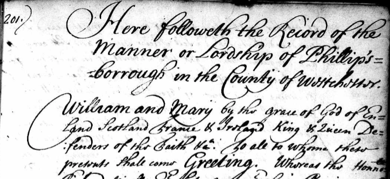
But the charter is very clear that, as far as the king and queen were concerned, his property constituted a “Lordship” and they repeat that word over and over (from Westchester deed B 201):
We have thought fitt according to the request of our said loving subject to erect all this aforesaid recited tracts and parcells of land and meadow within the limits and bounds aforesaid into a Lordship or mannor And therefor by these presents We do make erect and constitute all this aforesaid recited tracts and parcels of land and meadow within the limits and bounds aforementioned together with all and every the afore granted premises with all and every their appurtenances into a Lordship or Manor to all intents and purposes.
So, I guess if I could go back in time and ask King William a question it would be “Can you have a lordship and not be a lord?” But since I can’t do that, I will try to get in touch with historian Patricia Bonomi, who is really an expert in this time period in New York. I noticed in her book, A Factious People, that she refers to Philipse as a “proprietor” but not a “lord.” Maybe she has a good reason to believe that the other historians are wrong. I will let you know what she says if I can get ahold of her.
In a sense I agree that Frederick Philipse was not a “lord” as we tend to think of it. He was certainly no member of the nobility. And you are right of course that he obtained much of his wealth by marrying into money.
But he also was not merely a very rich guy who owned a lot of land and a bridge. And for those who do not know, he owned a large chunk of Kingsbridge and Riverdale including the Kingsbridge, which was the first bridge to Manhattan. He acquired his lands in our area in many separate purchases, which are recorded in ordinary deeds. Then, in 1693, his lands were declared to be “the Manor or Lordship of Philipsburg” in the charter that was issued in the name of King William and Queen Mary. Here is the preamble:
So what made his property a “Manor” or a “Lordship” as opposed to merely an estate? The charter gave him special rights as a lord that no regular property holder had.
One of those was the right to hold Court Baron and Court Leet in the Manor of Philipsburg. The rights to hold these courts go back to the medieval traditions of England and they were only granted to lords of manors. Here is the relevant section of the charter (transcription below):
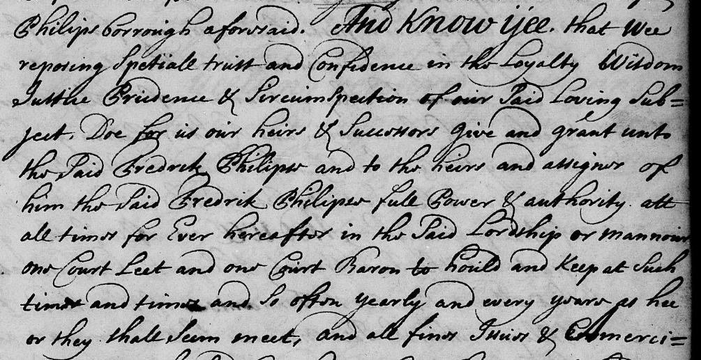
Transcription:
And know yee that wee [King William and Queen Mary] . . . grant unto the said Frederick Philipse and to the heirs and asigns of him the said Frederick Philipse full power and authority att all times for ever hereafter in the said Lordship or Manor one Court Leet and one Court Baron
Another special right that he received in the charter was that of an advowson and patronage to the churches that he would build in his manor. This meant that he could essentially appoint whomever he wanted to serve as the local clergy on the manor. This was a right that gave a lord special influence over his tenants:
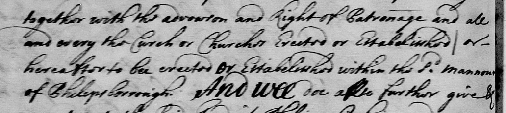
…together with the advowson and right of patronage and all and every the churches erected or established or hereafter to be erected or established within the said Manor of Philipsburg
Certain other rights like the right to charge a toll at the King’s Bridge and the right to appoint assessors were also included in the charter, which was signed by the governor of New York Colony, Benjamin Fletcher. So, in a legal sense he was given the rights of a lord, which is why Frederick Philipse and his heirs are commonly referred to as the “Lords of Philipsburg Manor:”
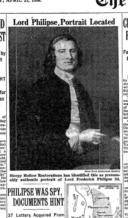
One thing that is strange though is that I don’t ever recall seeing Philipse referred to as a “Lord” in original 17th century documents. Only after the American Revolution do I come across documents referring to the Philipses as “Lords.” This leads me to believe that perhaps Americans started to refer to them as “Lords” as a way of identifying them as the enemy since the Philipse family stayed loyal to King George III during the Revolution. There is no indication that Philipse was particularly cruel or hard on his tenant farmers in Philipsburg. In fact, he charged pretty cheap rent! But it is still wild to think that Kingsbridge and Riverdale once had a “Lord” if only in a legal sense.
As you know, Tom, Riverdale, Kingsbridge, and Spuyten Duyvil were parts of Yonkers until the end of 1872. Most of historic Yonkers was part of Philipsburg Manor, the 52,000 acre estate of Lord Frederick Philipse, which stretched from Riverdale to the Croton River. I think our area may have been called “Little Yonkers” to distinguish it from the larger portion of Yonkers that was included in Philipsburg Manor. But I have only seen the term “Little Yonkers” used in a few documents and it does not seem to have been an official name.
Bingo, that’s it. Congrats to all of those who helped figure it out. The North Side Savings Bank gave away these plates at the bank’s opening on December 1, 1951. Here are a few closeups of the scenes depicted on the plate:
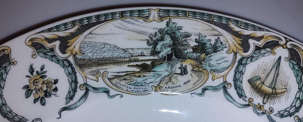
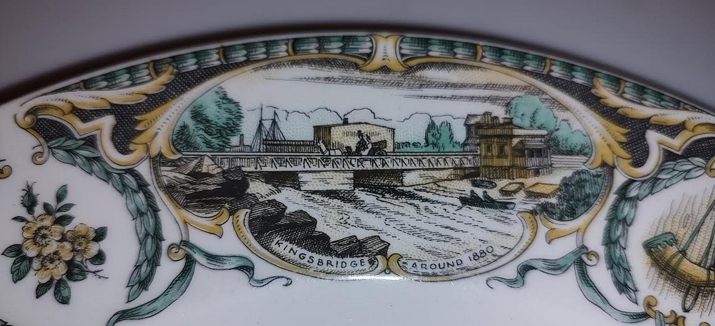
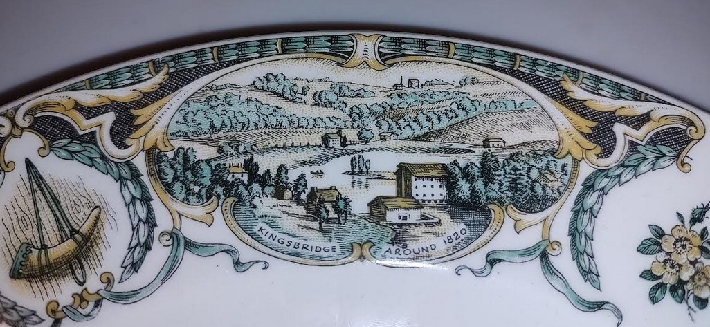
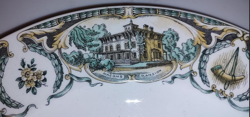
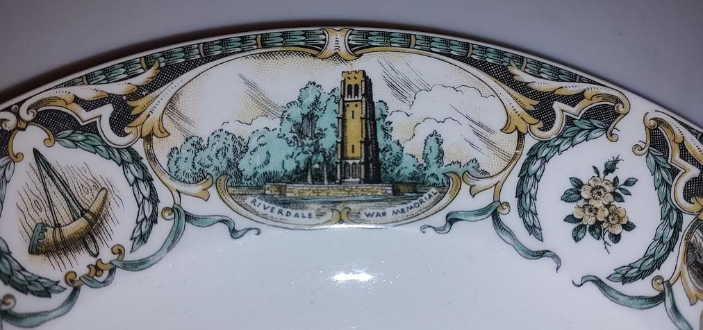
The newly formed Kingsbridge Historical Society played a role in selecting imagery for the plate, which you can still find on eBay for a resonable sum.
The film clip comes from a 8mm film reel in our collection. I was very excited to see it as it harkens back to the early days of the KHS and it shows the neighborhood in color. I can’t wait to show the film in its entirety at a future KHS event, possibly in the spring. The film depicts a number of events that would be difficult to understand without the help of the Riverdale Press as a historical record from the time period. I think it would be fun to show the film and explain it using RP articles. This is the clipping in our collection that explains the mystery scene:
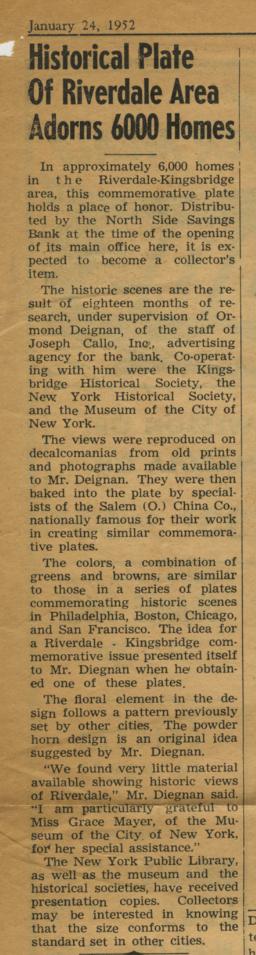
Okay, here’s a little hint. They were indeed giving something away at the bank opening–but not toasters nor copies of the Declaration of Independence. The line to the bank went around the block to get this free giveaway and 6,000 of them were handed out to local residents. Here is a screen shot from later in the film showing a patron who just walked out of Northside Bank with one of the mystery items. Can you figure out what it is?
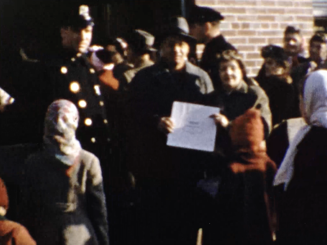
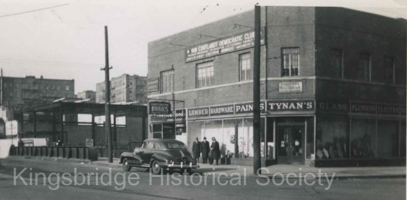
That is the building and that was indeed the occasion–the opening of Northside Savings Bank on West 231st Street in December of 1951. This film was shot before the construction of the Major Deegan Expressway so there are a number of buildings at the end of the clip that were torn down during its construction. Below is a photo from our archives of the bank building under construction on the left and Tynan’s hardware and Robert’s Books on the right:
By the way, there was a reason why so many people were lined up for the opening of this bank (and it wasn’t the savings account interest rate). Does anyone know why the opening was so well attended?
Yeah, I imagine that is a pretty rare postcard.
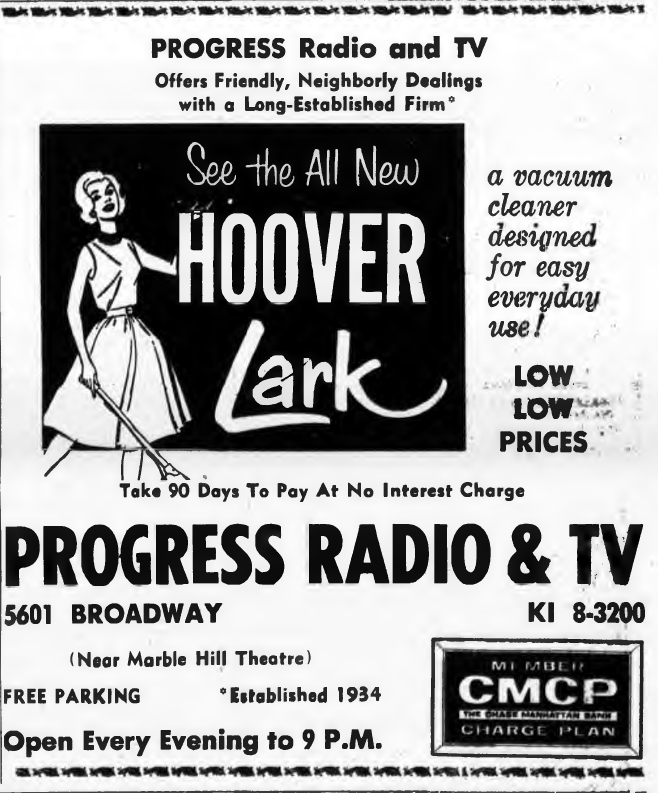
Nice anecdote about watching the inauguration of Queen Elizabeth on a Hoffman! Speaking of the Riverdale Press, I found this ad in a 1951 issue of the Riverdale Press indicating that Progress Radio had been in business since 1934:
Here is an example of one of Riverdale’s lime kilns (photo taken from William Tieck’s Riverdale Kingsbridge Spuyten Duyvil on p. 104).:
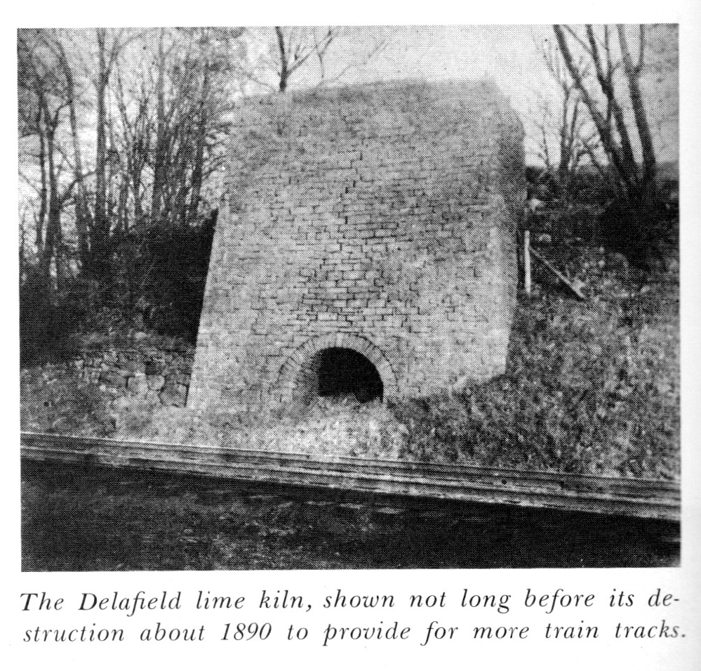 It is an example of one of the earliest forms of industry in this area.
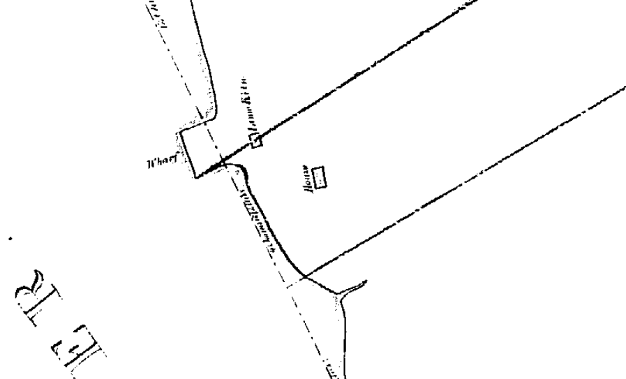
That’s an interesting point, Tom. There was a lime kiln right in that area and oyster shells can be burned to produce lime mortar. Below is a snippet from an 1840 property map depicting that section of Riverdale Park. Note the “Lime Kiln” just next to the wharf. The line traversing the kiln is the property line between Samuel Thomson and William C. Wetmore. The line just to the south is the property line between William C. Wetmore and James R. Whiting. So the structure labeled “house” would have belonged to William C. Wetmore.
If you check out the link that Buddy sent, you can get to this archaeological report. In the report conclusion, they wrote:
Located at the extreme south of the park, on a heavily eroded, steep-sided promontory, Site One is an area of extensive oyster shell covering approximately 4,30 square feet…
The recovery of industrical slag, coking fuel, wire nails, broken beer bottles, rifle shells, and a railroad spike has been attributed to the Euroamerican component. Rothschild and Fenton believe the relative scarcity of these artifacts, though, seems to indicate intermittent use as a dumping ground and recreational area during the nineteenth- and twentieth-centuries.
The prehistoric component is represented by a large amount of oyster shell which has been interpreted as the remains of aboriginal foraging activity. Additionally, Rosthschild and Fenton believe that the varying densities of shell suggests many occupational episodes over a number of years, rather than a single, continuous occupation.
The archaeologists also found the lime kiln (even though they did not know about the above map) but they never connected the oyster shells to the kiln. Another substance that was burned in lime kilns was limestone marble. It just so happens that the bedrock in that part of Riverdale Park is Inwood Marble. Perhaps the marble was used as a raw material as opposed to the oyster shells. We will be disscussing some of these questions with the geologist on our October 14th hike.
There is so much late 19th/early 20th century junk in that park beneath the surface that I wonder if it was used as a dump at some time. In Van Cortlandt Park trash was dumped in various swamps to raise the ground level. I wonder if something similar was done in Riverdale Park, possibly to fill in an old quarry. Or perhaps the neighborhood just needed a garbage dump and this was the location.
-
AuthorPosts