Home › Forums › Everything Else related to Kingsbridge, Riverdale, and Spuyten Duyvil › Hedley Hall
- This topic has 47 replies, 10 voices, and was last updated 3 weeks, 2 days ago by
jbakerjonathan.
-
AuthorPosts
-
-
August 5, 2024 at 2:53 am #4296
-
August 5, 2024 at 3:00 am #4297
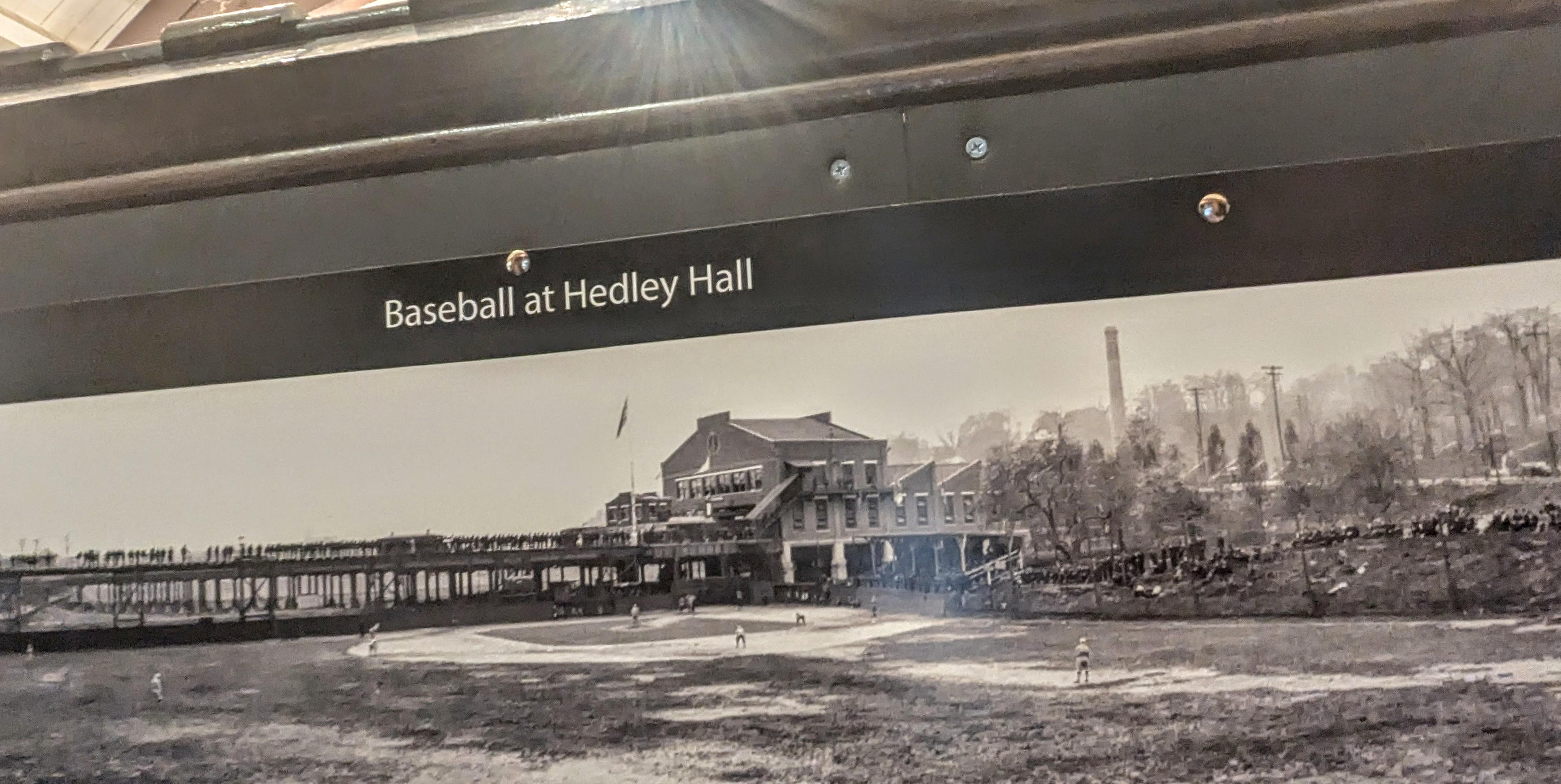
We had a healthy turnout yesterday for the ” Panoramas” open house at EDGEHILL yesterday. One of the visitors, Jerry Kisdlinger, was asking about the origins of ” Hedley Hall” pictured in a photograph of a baseball field. It seems as if it might be (or had been) a Manhattan College building, around 242d Street.
Does anyone know more? Thanks very much.
-
August 5, 2024 at 1:18 pm #4300
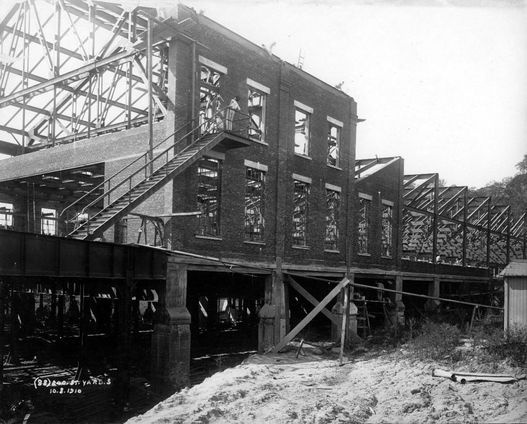
yes…we covered this area in #882 with the Train Yard building under construction in 1910
-
August 5, 2024 at 1:24 pm #4301
Or is it Hayden Hall ?
-
August 5, 2024 at 1:28 pm #4302
-
August 5, 2024 at 1:37 pm #4303
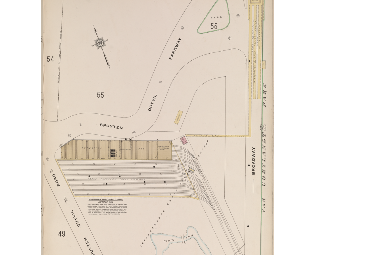
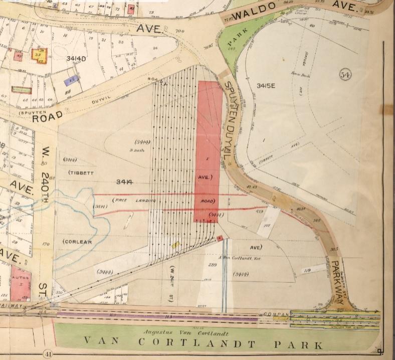
A map from 1914 shows the Bleachers Stands in the outfield
-
August 10, 2024 at 7:24 pm #4318
That’s an interesting map, Tom. The series of parallel lines are the train tracks so are the bleachers the red or yellow rectangle just above the tracks? The image is too small to read the details.
I don’t know where the name “Hedley Hall” comes from. It does sound more like a college building than a train shed but it was, and still is, a train shed.
The original image is held by the Museum of the City of New York but they don’t have a lot of information about it up on their website here. We reproduced it with a license from the MCNY for our exhibit.
The map posted below is interesting as well. Among other things, you can see the “Free Landing Road” outlined in red pencil. That area, which is now the Gaelic Park athletic fields was the Kingsbridge town dock. If you go to that area today, you would have no idea that boats ever docked there because it is completely landlocked.
-
-
August 5, 2024 at 1:46 pm #4304
Map from 1901
-
August 6, 2024 at 6:52 pm #4305
On the corner of W 242nd Street and Broadway there used to be a Gulf gas station and repair shop. I think that the photographer took the photo from close to that corner, before any development of that land took place.
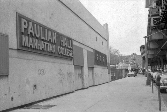
Soon after that photo was taken that land had an outdoor swimming pool constructed in left field as well as, in center and right field, a building along Broadway that housed a Pontiac dealership as well as the pool business and skating rink. I believe that in the 1950’s the pool was filled in and the building was taken over by Manhattan College and repurposed as Paulian Hall.
Here is a picture (credit: manhattan.edu) of the building showing the Gulf gas station at w 242nd Street in the background:
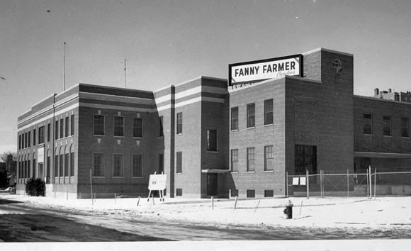
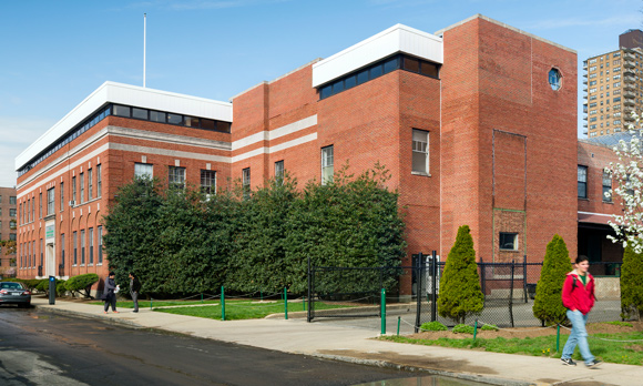
In 1949 Fanny Farmer built a factory near the corner of Corlear Ave and W240th Street that was purchased by Manhattan College (MC). It was in that building that MC housed a nuclear reactor in 1963.
Here are before and after pictures (credit: manhattan.edu) of the building:
Fun fact: I used to see Sugar Ray Robinson driving in his pink Cadillac convertible on W 240th Street. I assume that he had been visiting his mother whose house was on Corlear Ave.
-
August 10, 2024 at 7:28 pm #4319
Thanks for sharing that information and those memories, Jonathan. So was the Fanny Farmer factory making candy there?
-
-
August 6, 2024 at 7:18 pm #4306
As I see no evidence of 4568 Manhattan College Pkwy in the background, so I would say the picture was taken some years before 1925, the construction year of that apartment building. I don’t see Manhattan College (MC) either, so the picture was taken before 1922, the year MC cornerstone was laid. The 240th Street Yard (the train barn) was completed in 1911. I would say that the picture was taken between 1911 or 1912 and 1922 or before. I’m going to put a number on it and say that it was taken in 1915 (for want of anything more concrete).
-
August 7, 2024 at 1:20 pm #4307
I do not know when that building became Paulian Hall, but it was a pool hall downstairs and I was in a Bowling League upstairs from about 1969 – 1974.
-
August 7, 2024 at 6:12 pm #4308
According to manhattan.edu, Manhattan College purchased the building in 1957 and opened it in 1958 as Paulian Hall. They sold the building in 1966.
I remember peering in when walking by and seeing skaters. I also somehow got into the pool in the back when it was closed and empty of water and wondering about the gymnastic rings hanging by ropes. Luckily, they were too high for me to reach or I probably would have climbed on them. Falling off of them onto the concrete floor would not have been pleasant. This occurred before 1957, possibly in the mid to late 1940’s.
I lived up the block (W 242nd street) at 4652 Manhattan College Pkwy. I remember the owner/manager of the Gulf station whose name was Hans who also had an old German shepherd dog. I used to fill my bicycle tires with air from the air pump stand (free in those days 8^). Sometimes the dog would wander up to me to say hello. Across the street from the gas station, on the curve toward the entrance to the train station, was a French Bake Shop. My mother had a part-time job behind the counter in 1938-1940. As a teen I would wet mop the floors after school (c.1951).
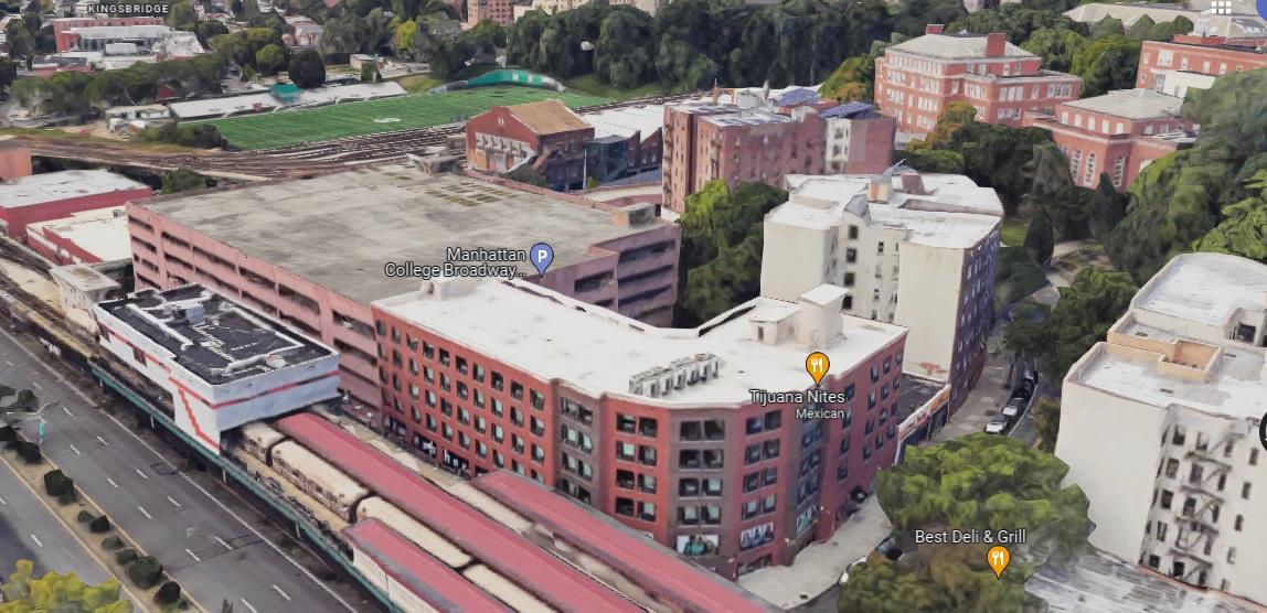
The building is now a parking garage. There is an entrance to it on Manhattan College Pkwy with a pedestrian walkway from the College to it. I’m not sure if there is any affiliation between the two, or if it is just a convenience for students and faculty who might park in that garage.
-
August 7, 2024 at 6:16 pm #4309
The Paulian building probably was razed and replaced by the parking garage, though I have no information on that.
-
August 10, 2024 at 9:12 pm #4320
Yes, Nick, that factory made various chocolates. The aroma was mouth watering at times. I’m not sure why the decision was made to sell to Manhattan College.
-
August 10, 2024 at 9:37 pm #4321
Tom, the map from 1901 shows the IRT train tracks and 242nd Street station as well as the 240th Street Yard. From what I can find the Yard first opened in 1906 with the barn finished in 1911 and the train station opened in 1908. Do you think that the planning of those was completed sufficiently before to be included in the 1901 map? Or could there be some other explanation?
-
August 11, 2024 at 10:18 am #4322
Nick, your link to the original photograph of “Hedley Hall” states that it was taken from W 242nd street circa 1916. I’m thrilled that my guesses were so close!
The description of the photo says that the field was “Interborough Field”. Was the land extending from the 240th Street Yard to W 242nd street owned by the Interborough Rapid Transit company (IRT)?
In the 1901 map there appears a road labeled “Road”. Do you think that that may have been Irwin Avenue? Did it actually connect with the intersection of Waldo Ave and Spuyten Duyvil Pkwy?
I can’t seem to paste a picture of the Street View of the intersection of Waldo and Manhattan College Pkwy looking down what may have been Irwin Ave (with boulders to the left of the path). Many years ago there was a stone retaining wall just to the left of the sidewalk that extended from the intersection to past the front of the red building with the glass façade (Kelly Student Commons). There was a drop off to its left, on what I think was the Irwin Ave side. My recollection from 1942-1943 is that there was no road there.
-
August 11, 2024 at 3:27 pm #4323
Hi, Jonathan,
The “1901 Map” is an insurance atlas map. These were periodically issued, and then were added to as improvements were built. So the map remained dated 1901, even as it was continuously amended to show improvements that came afterward, until such time as a whole new map was issued. There was no way, in 1901, to have anticipated that there would be a maintenance building there, as the original IRT plan had the Broadway Local terminating at 230th Street and Bailey Avenue, where it would connect with the New York Central 230th Street station.
-
August 11, 2024 at 4:18 pm #4324
Anonymous
Thanks for that info, Tom. I’ve looked at a lot of those insurance maps but didn’t really know how they were used.
As for Jonathan’s question about the section labeled “Road” on the 1901 map… That is the very useful footpath used mostly by Manhattan College Students that goes from the intersection of Waldo and Manhattan College Parkway down to Irwin Ave and W. 240th Street. I think the large boulders are still there. I have seen it mapped as a road going back to the 1800s but I am not sure if it was ever used for vehicles. In smaller lettering on the map you can see it labeled “Spuyten Duyvil Road,” which I believe is the old name for Irwin Ave.
-
August 11, 2024 at 8:46 pm #4329
Thanks for the clarification, Tom. In my field of endeavor I was always aware of the need to highlight any revision to documentation. Without revision letters, I wonder how those maps were not a cause of confusion, unless those revised maps were somehow identified.
Testtesttest, I was aware of the footpath. One of my friends who lived at 3875 Waldo Ave would use the path to get to Broadway and a meat market in that area. I wonder if it ever had become a road, though that seems very unlikely.
-
August 12, 2024 at 2:15 pm #4330
The insurance maps in NYC were published by either Sanborn or Belcher Hyde for use by insurance companies. The buildings are color-coded. Red is a brick building. Yellow is wood frame. Yellow with a red fringe is wood frame, with brick face. Blue is stone. Gray is iron. Insurance companies would set their rates accordingly. If a new building replaced an old one, the staff would cut and paste the new structure right over the old. They often did it so artfully that you can’t tell, unless you have the actual original in front of you. Most of the additions that you see on that bit of the map were just drawn in. These maps are widely available online.
I’m a Manhattan College graduate. I walked up and down that path 1,000 times. It is a public street shown as “Waldo Walk” on the current tax map. I doubt if it was ever open to vehicles. The large rocks on the north side of the path were blasted away for the Raymond Kelly Student Commons Building. The ones on the south side, which made a great visual and sonic backdrop for the Gaelic Park concerts of the 1970s are still there.
-
August 12, 2024 at 2:49 pm #4331
Thanks for that additional info on the insurance maps, Tom. I would assume that any map shown on the publisher’s website would be considered the latest and greatest. But, how were things handled back in the early years of the 20th century?
I have an unknown Manhattan student to thank for saving my life back in 1943(ish). In the middle of summer on a very hot day I had grabbed an ice cube from the refrigerator and was sucking on it as I walked up Spuyten Duyvil Pkwy. Class had just let out and students were walking down to the subway. The ice cube got caught in my throat and I couldn’t breath. I suppose that I was clutching my throat when one of the students bent down, grabbed my ankles, swung me upside down and hit me on the back. The ice cube popped out and I was put back on my feet. The student continued to walk away as I recovered. Luckily, I was a small, lightweight kid and he was a strong and quick-thinking person. I guess engineers are kind of bright individuals 8^D
-
August 12, 2024 at 3:14 pm #4332
Hi, Jonathan,
Good story about the unknown Jasper! I’m a sucker for happy endings.
I don’t always tout Wikipdia, but look at their article on Sanborn Maps. It gives a very good history and good rundown on how they work. I have over 40 years in the title insurance business, and I do history and architecture walking tours in the city. These maps have been invaluable in each of these pursuits. But always there is the caveat – The date can be misleading!
-
August 12, 2024 at 5:01 pm #4333
The Sanborn Maps wikipedia page explains how the maps were kept up to date. It was very labor-intensive, sending out a cadre of people to physically paste new information on each map held by subscriber businesses. Wow!
-
August 17, 2025 at 2:02 pm #4938
On the subject of the updated insurance maps—the KHS arcvhive recently received a G.W. Bromley atlas dated 1922. On the inside cover is a list of all the updates—the latest for this atlas being 1927. Never saw this before, since I’ve only used the maps online and never actually handled an
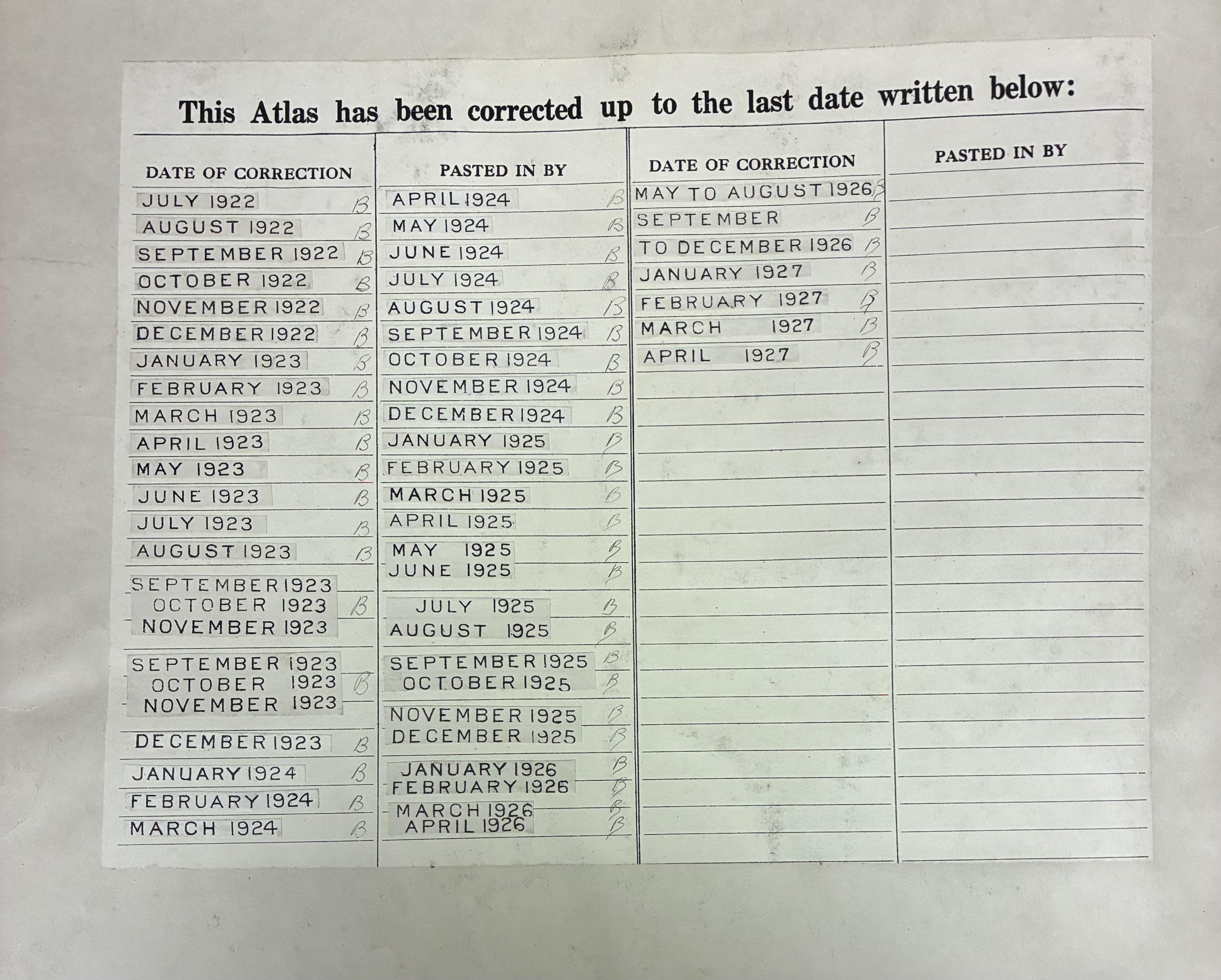 entire atlas. FYI, this atlas covers 145th St. to Spuyten Duyvil.
-
-
August 8, 2025 at 3:29 pm #4878
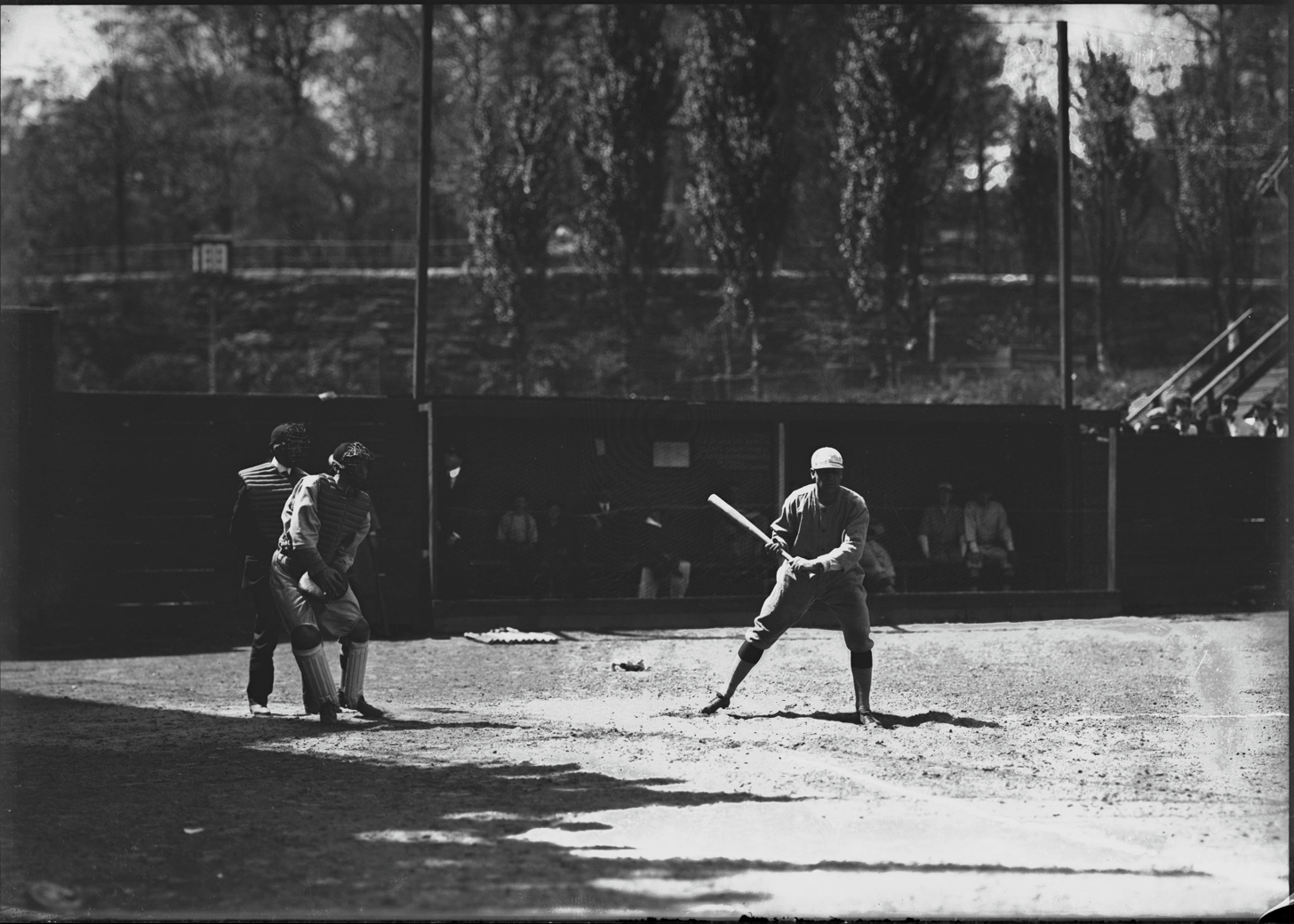
Hedley Field (aka Hedley Oval in 1924)
-
August 8, 2025 at 3:32 pm #4879
From the NYHS dated 1918 at unknown location in the Bronx (I believe it to be Hedley Field).
-
August 8, 2025 at 3:35 pm #4880
-
August 8, 2025 at 3:35 pm #4881
-
August 9, 2025 at 3:12 pm #4887
Tom
The Bowling Alley/Pool Hall was actually south of the transit workers foot bridge that still goes from the tracks to the headquarters building. It is now a church Palabra de Dios.
Paulian Hall (Pontiac showroom) is north of the footbridge next to the old Gulf station and the intersection of 242 St and Broadway.
-
August 9, 2025 at 3:18 pm #4888
JBaker. Thanks for reviving the memory of the French Bakery on 242 St.
They had the most delicious cheese buns, cinnamon donuts and a sliced bread called Daffodil Farm.
I still compare all cheese danishes to those and Ha Ha none have surpassed them yet.
-
August 9, 2025 at 8:18 pm #4889
Karlreinsons (Karl?), the pastry chef was Teddy, who, I think, had Parkinson’s Disease. I watched in amazement when he would approach a cake with the icing bag very noticeably shaking, and then make beautiful designs with no shaking. The baker and owner was Placid Calluso. His wife was Marie, I think. I always addressed her as Mrs. Calluso. They had one child, a girl named June, or Junie as we called her. She and my older sister (by 5 years) were great friends.
-
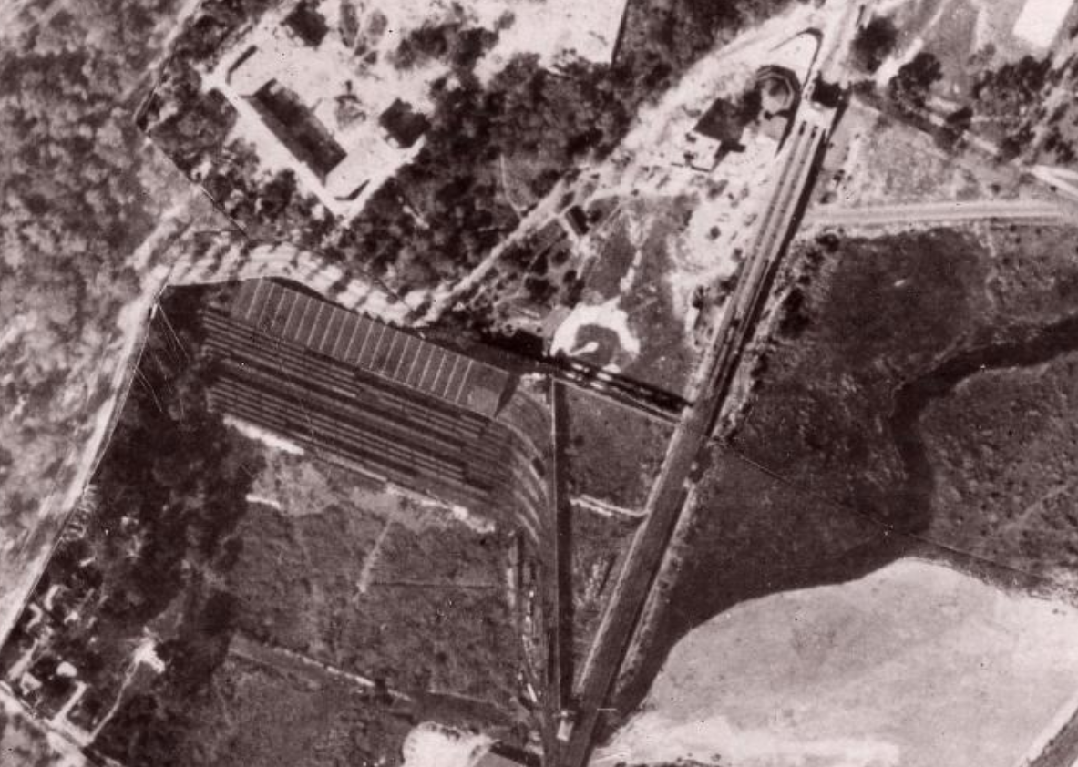
August 9, 2025 at 8:32 pm #4890
tmara2, thanks for the photos. I believe that you are correct in thinking they are of Hedley Oval. The elevated station has what looks like the signal building and crew quarters that are a part of the 242nd Street station.
Could you provide a link to the first photo? The aerial view includes my old apartment building that was completed in 1923. It also shows the carousel building adjacent to the North stair entrance to the train. I’m interested in that, too.
-
August 10, 2025 at 7:18 pm #4900
“NYC Then & Now” – go to the right side of the slider & scroll down & select 1924, which should bring up that aerial view on the right side & should keep the latest aerial view on the left side of the slider:
https://nyc.maps.arcgis.com/apps/instant/media/index.html?appid=e011fd05a86a4c09bd0b91fbc387f3eb
-
August 10, 2025 at 7:44 pm #4901
Thank you for the link to NYC Then & Now. It’s a fascinating map. Alas, zooming in doesn’t improve the definition at all for my neighborhood. It’s interesting to see the changes. I can recall the flower arrangement that the Parks Department planted in front of the Manor house. It really was breathtaking to see the hundreds of flowers neatly planted in the grid pattern, with the marble fountain in the center. The last time I was there, probably 10 years ago, the fountain was boarded up with plywood sheets. From the 2024 photo is seems to be completely missing. Sad.
-
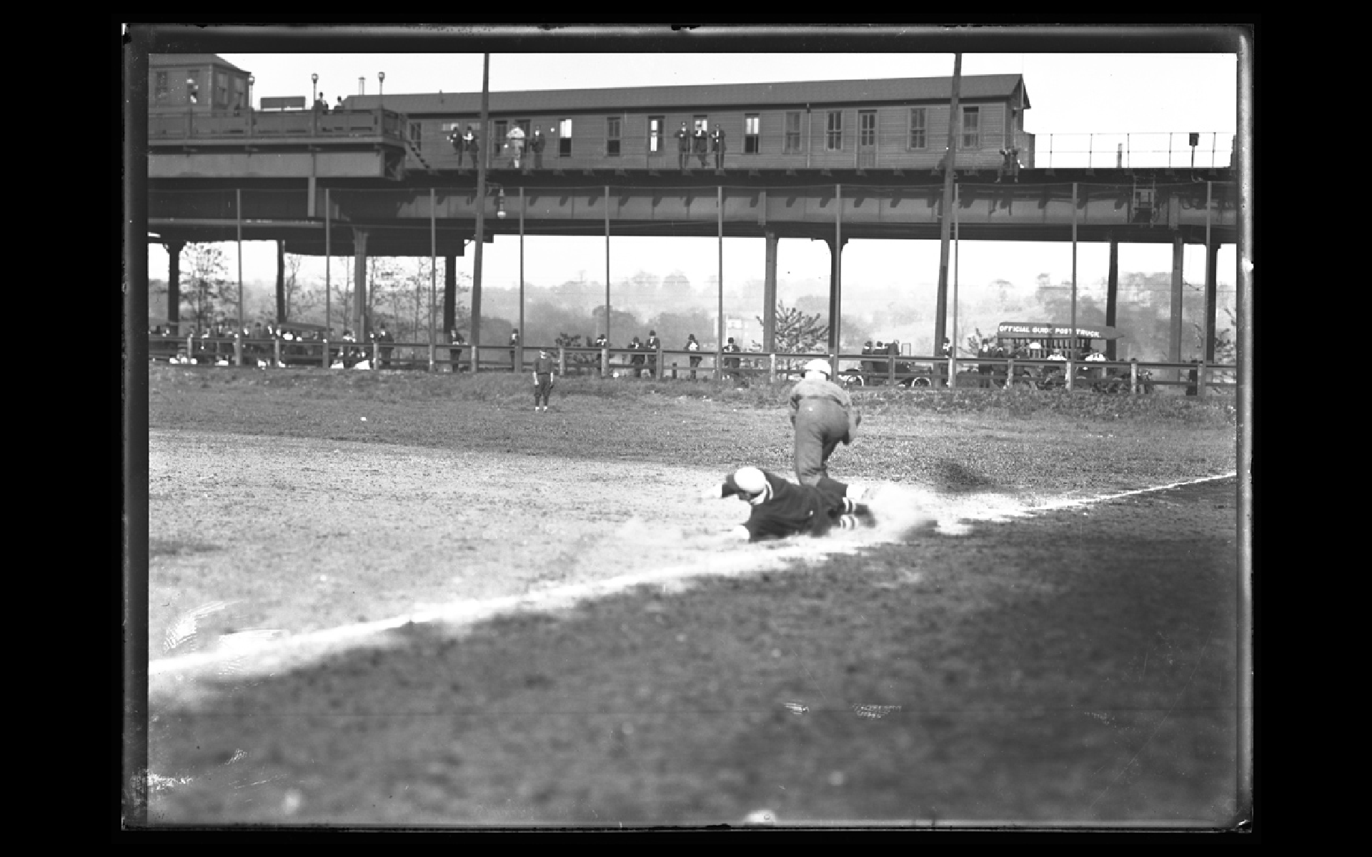
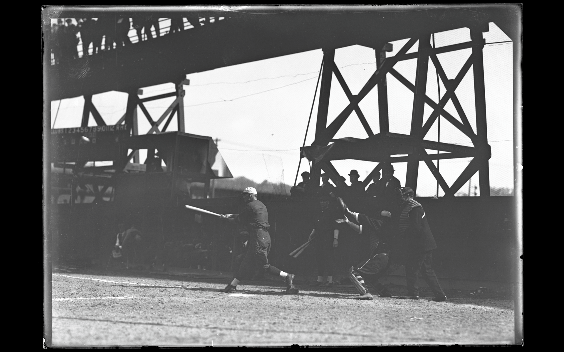
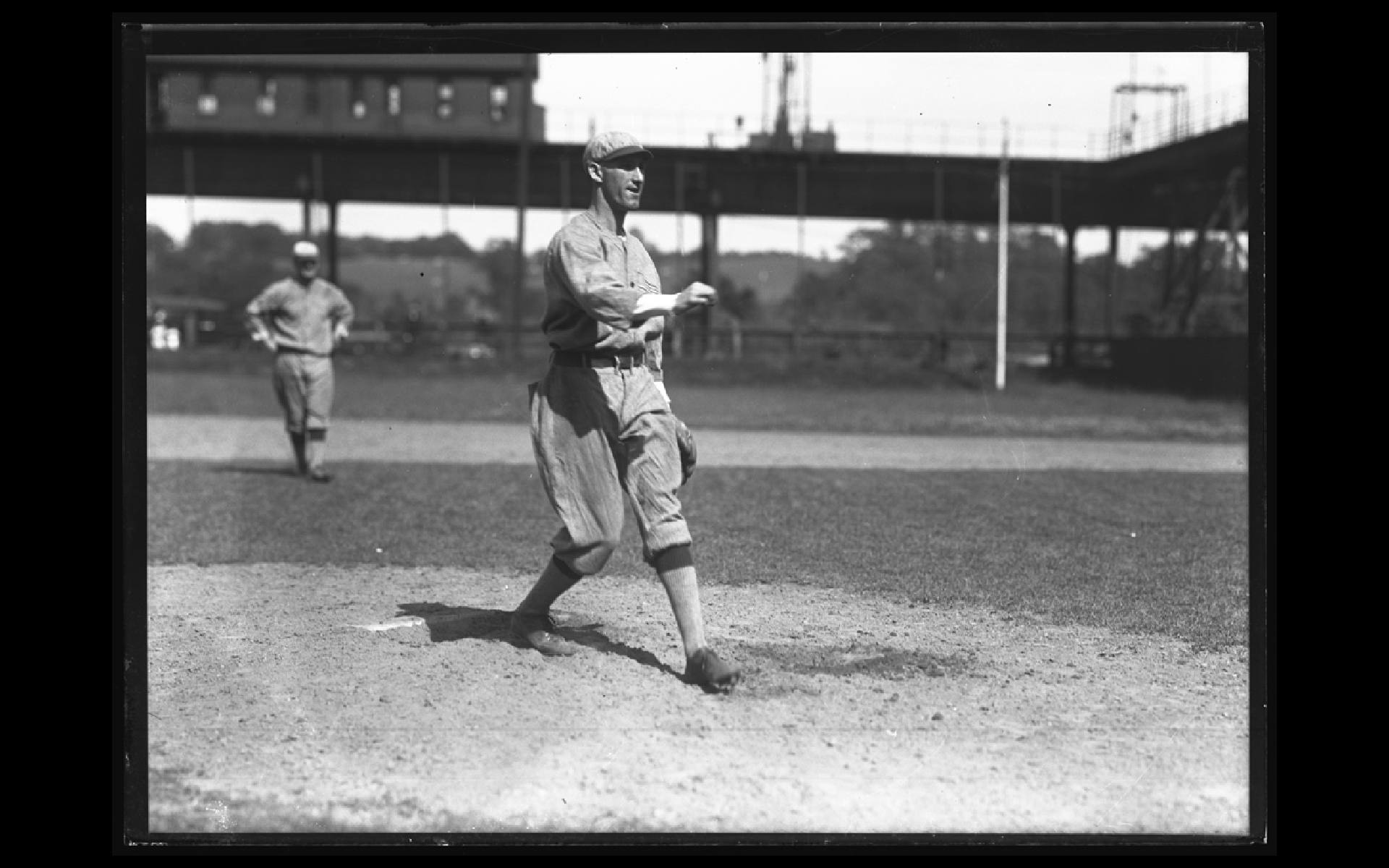
August 10, 2025 at 7:54 pm #4902
Another view from the 1st base side. You can see Spuyten Duyvil Parkway (now Manhattan College Parkway) rising in the background. These pics come from the Interborough Rapid Transit Company archives & the teams are probably made up of subway workers.
-
August 16, 2025 at 2:11 pm #4925
Jonathan
Thanks for the info on the bakery on 242 St.
What was the name of it ?
-
August 16, 2025 at 2:22 pm #4926
Jonathan
As a kid in the mid 50s I remember the floral displays ( mostly begonias) around the Fountain. If I remember correctly, even then the fountain was no longer functional.
The flowers were gone by the end of the decade as VC Park and the Bronx started their slide into neglect.
My building (230 West 242 St) was supposedly built in 1920 but does seem to appear on that overhead.
interesting that the carousel still existed at that time.
-
August 16, 2025 at 6:59 pm #4934
Karl,
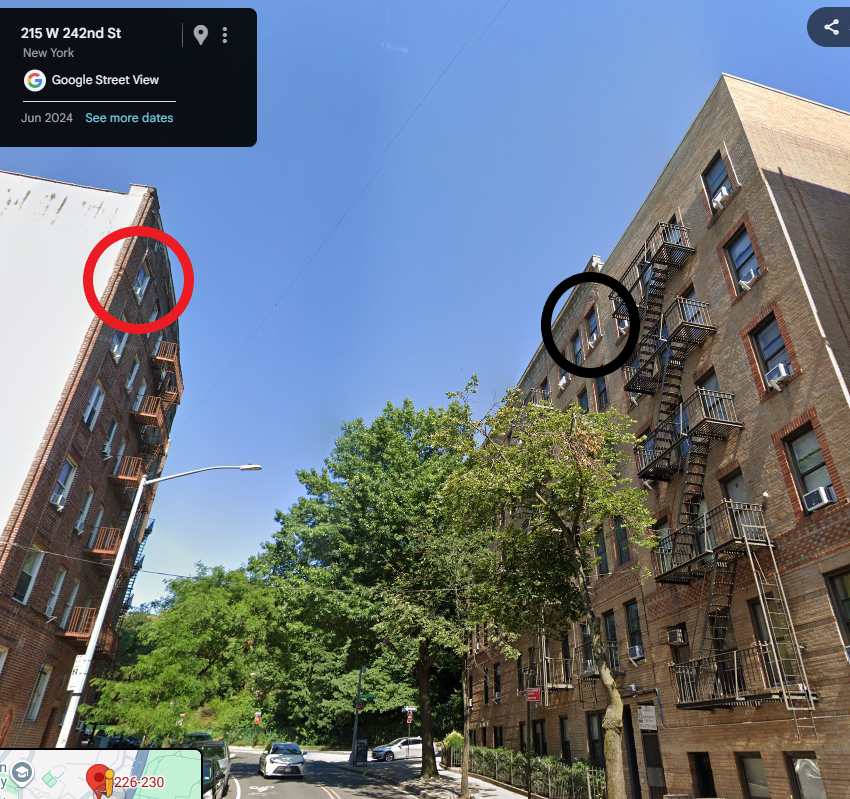
According to NYCityMap 226 W 242nd Street was constructed in 1924. My building, 4652 Manhattan College Pkwy, was constructed in 1923.
I have a story about when I was a teenager and lived there. One afternoon after school I was in my room and heard loud voices. I looked out my bedroom window across to 226 and saw a fight going on in the top apartment between teenage brothers. One of the brothers was knocked against the window so hard that it broke the glass and the sash, He almost went out onto the street but luckily didn’t. I mean, he grabbed both sides of the window opening to prevent his falling. It was surreal. The picture shows my bedroom window in the black circle and the other bedroom window in red.I think that the name of the bakery was The French Bake Shop or maybe The French Bakery.
I was attending CCNY in the Fall of 1950 and then transferred to a college in North Carolina and was basically away until I got out of the Army in 1963. Prior to that we were neighbors 8^)
-
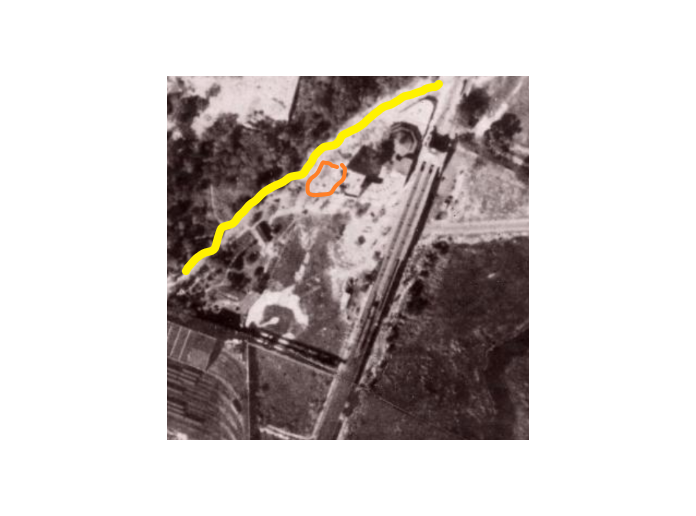
August 16, 2025 at 7:53 pm #4937
Closer examination of the aerial photo leads me to believe that my apartment building is not in the picture, at least not completely constructed. The orange shape is where my building should be in the year 1924, right next to 215 W 242nd St. that is shown and casts a shadow. The yellow line is Spuyten Duyvil Pkwy which should go right past 4652. Perhaps construction has just begun. The resolution isn’t good enough to say for sure. According to NYCityMap, both 4652 and 215 were built in 1923 and the Then & Now app claims the photo was shot in 1924. One of those two sources isn’t completely right. Frustrating.
-
August 18, 2025 at 5:20 pm #4949
JBaker
Thanks for the info on the French Bakery.
It might just be the quality, but the photo that you drew the yellow line on doesn’t seem to show 242 Street
-
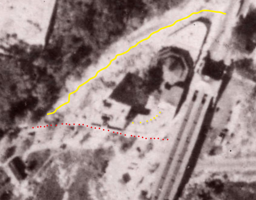
August 19, 2025 at 8:30 am #4957
Karl, the red dots show 242nd street, the yellow line shows SDP and the yellow dots show the one-story buildings on the curve, one of which would house The French Bakery.
-
August 23, 2025 at 2:52 pm #4966
Thank you very much Jonathan
-
April 3, 2026 at 6:28 pm #5193
https://nytransitmuseum.catalogaccess.com/photos?search=&page=475&size=50&withImages=falseScroll
Scroll down to “Swimming Pool”
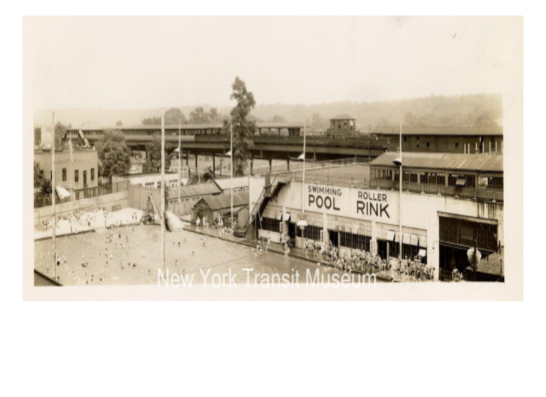
I was scanning through the N.Y. Transit Museum looking for photos of W242nd Street and came across this photo of the swimming pool and skating rink that I mentioned in my post #4308 above. The pool and rink supplanted the baseball field. The photo was probably taken from the catwalk that went from elevated train tracks to the repair barn. The photo is undated.
The low white building that is behind the pool’s vertical light posts may be the Gulf gas station (or not) and beyond that building is the wooden building that was just south of the carousel, both shown in the aerial photo in post #4957. -
April 3, 2026 at 9:50 pm #5194
Thank you to everyone that have posted to this topic. Loved all the baseball action, maps and memories. I get many notices but missed a lot of these updates until today
-
April 6, 2026 at 2:45 pm #5203
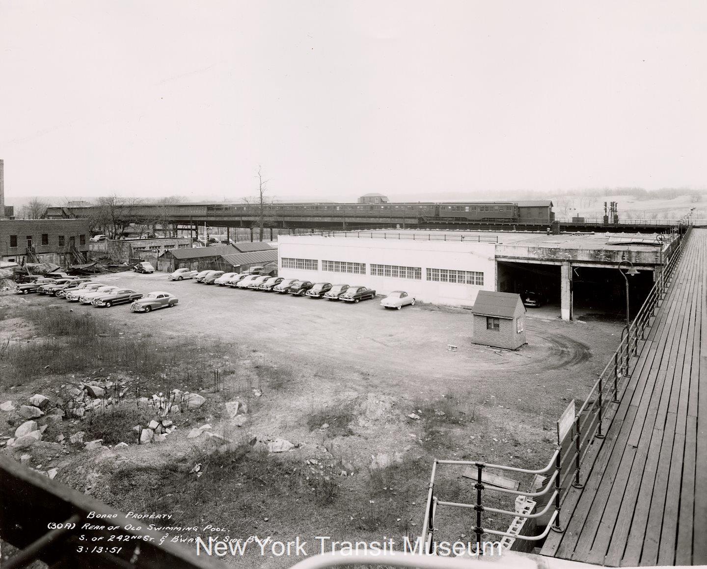
Also from the Transit Museum collection, an auto dealership parking lot has replaced the swimming pool.
-
April 7, 2026 at 3:46 pm #5204
I enjoyed seeing the Pool and Rink photo didn’t know there was once one there. Today there is a NYC Parks swimming pool just across the street. There were originally two NYC pools, a swimming and diving pool. But a few years after being build the diving pool cracked. Another NYC Parks designed project. It was built over the submerged Tibbetts Brook and built on marsh lands and not well designed hence it being abandoned in just a few years.
Today swimmers at the V.C. pool can only wear WHITE t-shirts. Because there is a concern some children might wear Red or Blue colored T-Shirt that might be interpreted as a gang color. I can’t imagine that being a problem when the old Pool and Rink were active.
-
April 7, 2026 at 6:59 pm #5206
tmara2, that is a great find! I see that the wooden building I referenced is no longer there behind the Gulf station. Looking at NYCMap the development of that corner where the wooden building was, occurred in 1931, so my picture must have been taken a little time before 1931.
Peter, was the diving pool located just north of the existing pool? Google Earth seems to show a filled in square area. I can say with certainty that during the 1940s and up to 1955 there were no gangs in the area. It’s a shame that concern over gangs are with us today.
-
-
AuthorPosts
- You must be logged in to reply to this topic.