Home › Forums › The Industrial Era › 1893 Photo of Ship Canal & Farmers Bridge
- This topic has 5 replies, 3 voices, and was last updated 6 years, 2 months ago by
Alan Lasky.
-
AuthorPosts
-
-
May 16, 2020 at 10:10 pm #1432
This photo is mislabeled as Ohio, but is actually an amazing view from the south side of the Ship Canal, looking northeast. The Farmers Bridge is near the right edge, and there is a railroad crossing leading from the bridge to Kingsbridge Rd.225th St (then called Muscoota St) runs across the middle, from the white rocks at the left to The Farmers Bridge at the right.
The marshy area at the center will be filled in by about 1916, and will be the site of the velodrome in the 1920s, and Target today.
The hillside in the back runs from Exterior St at the base to Sedgewick Ave and Kingsbridge Terrace at the top.
The folks in the photo are where Broadway meets the south side of the Harlem River Ship Canal, which is not yet completed at this time, and it appears work on the the first Broadway Bridge has not yet begun.
The roaring current exiting the Ship Canal towards The Harlem River would seem to indicate this is shortly after April 20 1893, when a storm and record tides caused the coffer dams on either end of the Ship Canal to give way, connecting the Hudson and Harlem Rivers.
The Ship Canal was close enough to completion at that time that the coffer dams were not rebuilt, and the last two years of construction were done via dredging and underwater blasting.
Prior to the April storm, during construction, access between Inwood and Marble Hill was via a temporary road built across the top of the coffer dam on the Broadway side. That was destroyed in the flood, and hastened the construction of the first Broadway Bridge, which opened on January 1, 1895
Before April 20, the Ship Canal looked like this…
…with water excluded by the coffer dams on either end. Clearly, in the 1893 photo, the dams are down and tides are flowing between the Hudson and Harlem Rivers .
This photo…
…taken nine years after the 1893 photo, is looking north across the first Broadway Bridge towards 225th St. The angle is almost exactly the same, and the houses along the skyline provide the verification the the 1893 photo is Kingsbridge, not Ohio.
Here is a modern simulated view via Google Earth
…and a map showing some of the historical geography of the area…
-
May 17, 2020 at 4:12 am #1434
Alan another great group of photos and story of the flood and dam breaks. Very interesting new material. Thanks very much. The photo below is from.May 8, 1905 of the Claflin Mansion that is the rectory of Our Lady of Angels church, 2860 Webb Ave. This is the large house shown on the ridge of your initial new photo and the 1902/3 comparison photos.
-
May 17, 2020 at 10:35 am #1435
Incredible, astonishing work aligning those two photos. And that mansion is still there on street view too, I’ll have to take a hike and check it out. Finally getting a feel for the way Marble Hill was detached from Manhattan… next to impossible from the written descriptions. Thanks!
-
May 17, 2020 at 4:15 pm #1436
Peter, I’ve been struggling to identify some of the buildings, and the only one that looks to be in the correct position to be 2860 Webb Ave would be the one at the far right, straight up from the Farmers Bridge RR crossing.
The only one I am pretty sure about is the big one at the center, which looks to me like the Samuel W. Fairchild residence, which was about where the SE corner of the school at 120 W 231 St exists now. I believe it was still there in the 1924 aerial survey, but appears to be gone by 1938 maps, and doesn’t show up in the 1940s tax photos.I found a pic of it in “The Great north side, or, Borough of the Bronx, New York (1897)” and here is a comparison of that pic and the building at top center of the 1893 photo
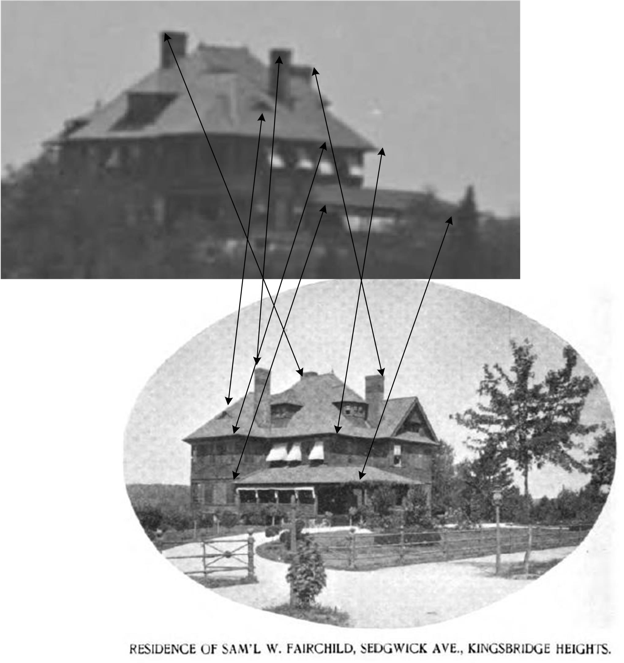
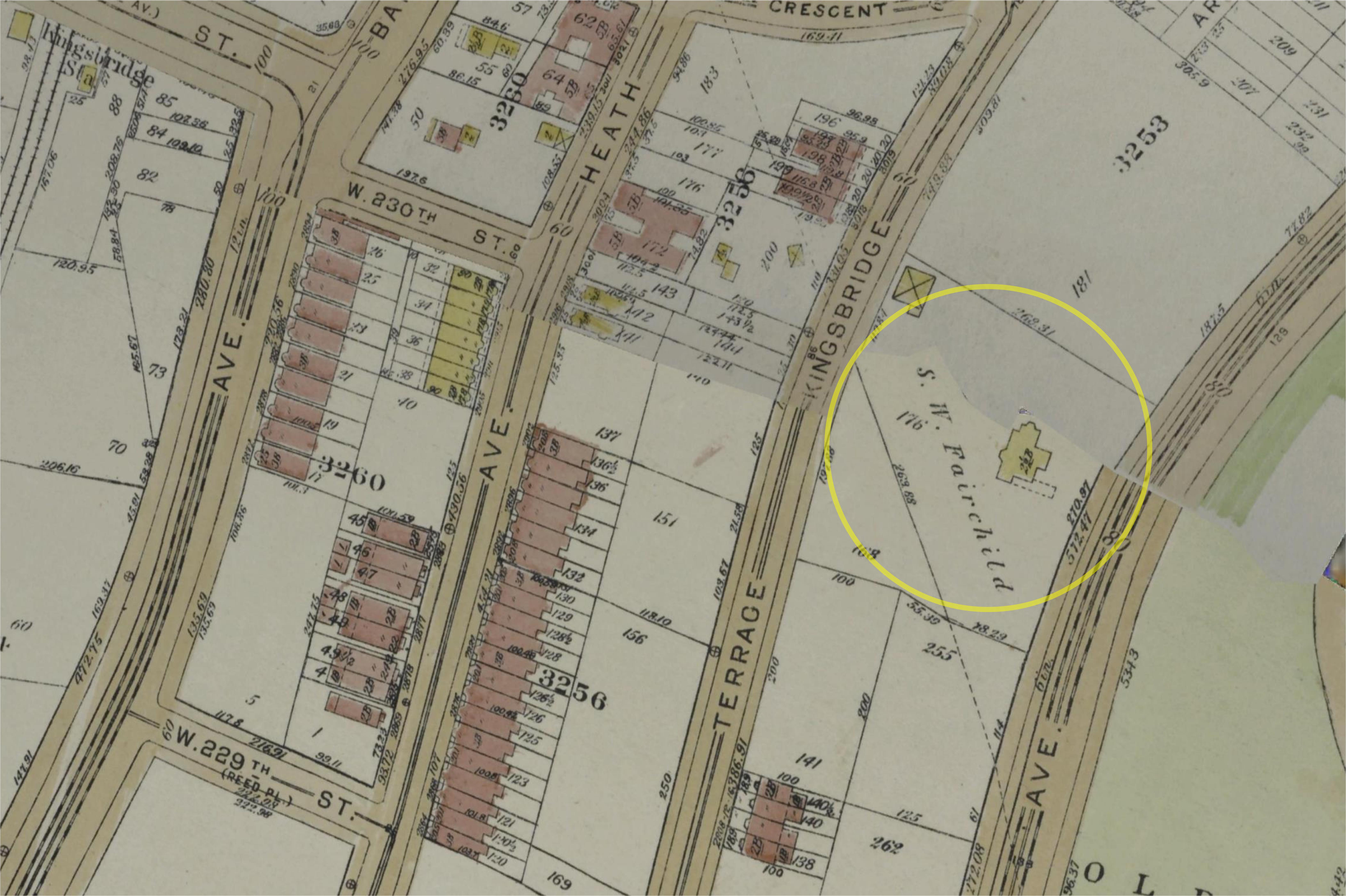
Here it is on a 1921 map …
It also shows up in this picture, which I have cropped somewhat here
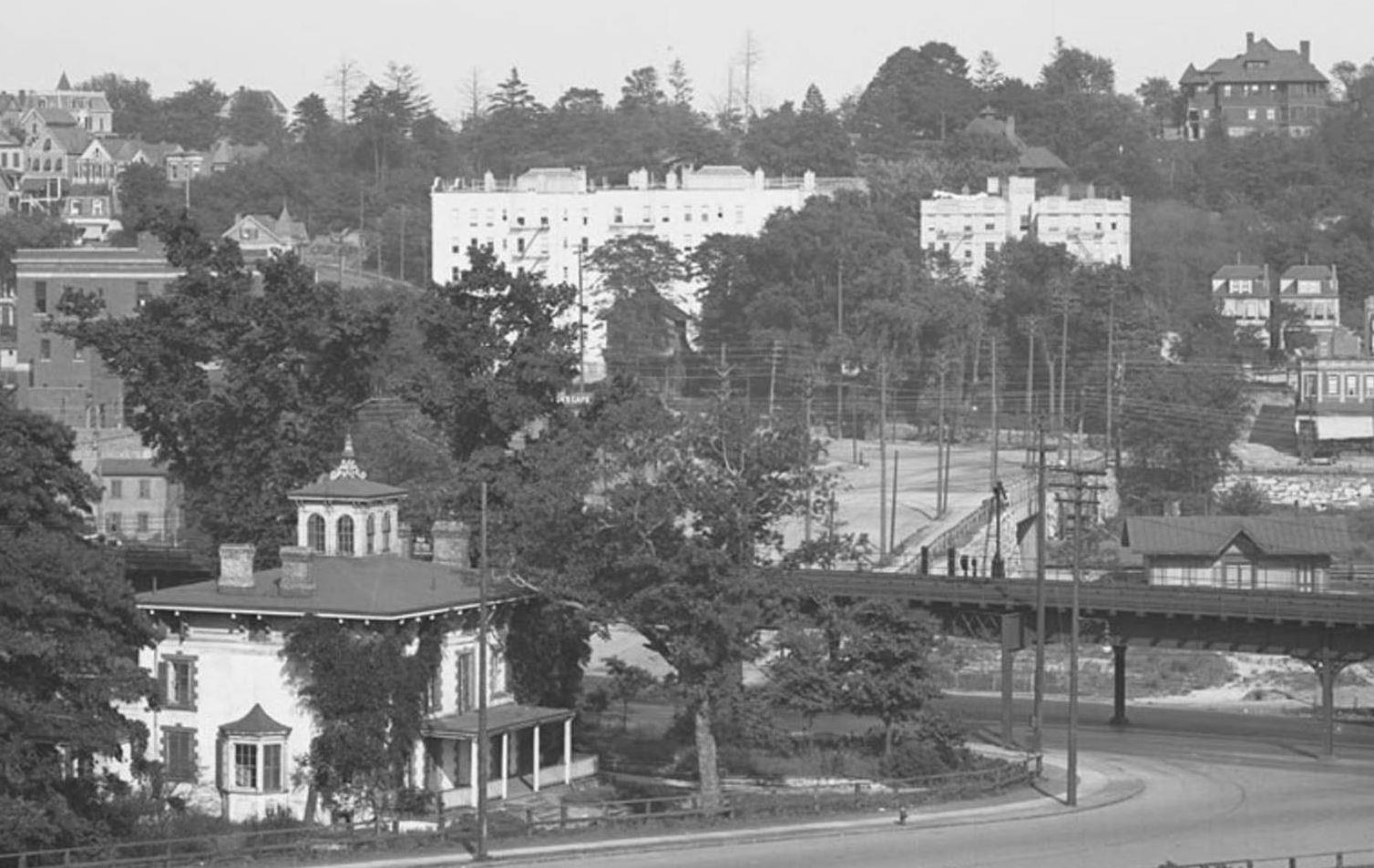
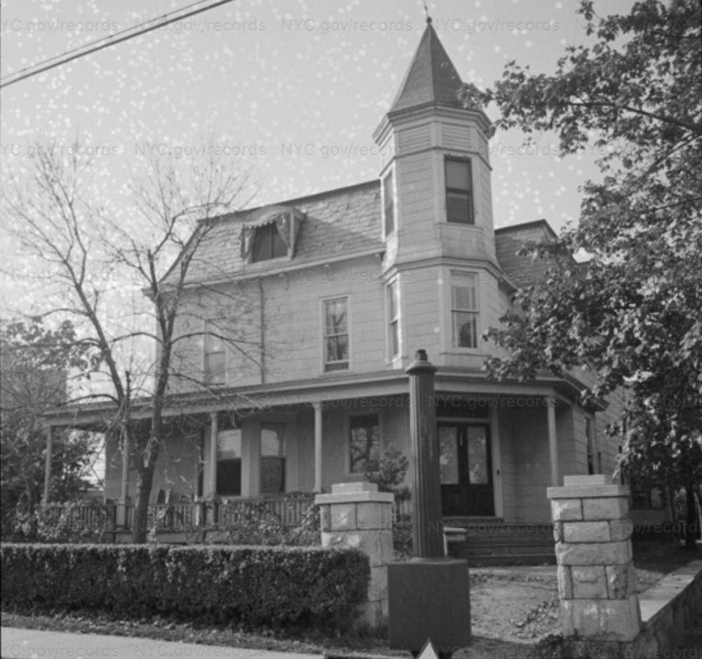
In this crop, the Fairchild mansion is at upper right, and at upper left I would guess is 3065 Sedgwick, also possibly visible in the 1893 photo, which looked like this in the 1940s tax photos.
There are a few others that might be IDed with a lot of work, but so many are gone, often with little or no photo record.
It is always a treat to discover a photo trace that WAS left behind. -
May 18, 2020 at 12:20 am #1438
Alan – as they say in football ” upon further review of the judges” you are correct the large mansion in your photo is the Fairchid Mansion while the Claflin Mansion is slightly further back and to the right. I had always assumed it was the Claflin mansion. In Dr Tieck’s books there are a few photo that identify it as the Claflin mansion as we know now is incorrect. Having grow up across the street from the Claflin Mansion/OLA Rectory I never gave it a thought.
I had no idea or heard of the Fairchild Mansion. Interesting it was only on the next block (Sedgwick Ave) from the Claflin Mansion on Webb Ave. The Fairchild Mansion looks to have been were the later John Peter Tetard Junior HS was later built, today the school has a new name.
I had to look up who is Samuel W. Fairchild. He was born in Stratford Ct in 1853 and died on Nov. 13, 1927, at his home, 3001 Sedgwick Avenue, Kingsbridge, at the age of 75. He was a former president of the Union League Club, and at his death, vice president and a director of Fairchild Brothers & Foster, 70 Laight Street. Long an outstanding figure in the manufacture of chemicals, Mr. Fairchild founded the firm of Fairchild Brothers in 1879.
The Claflin Mansion was the summer home of Horace B. Claflin a Dry Goods Merchant who was for a time the riches person in the United States in the 1870’s. His mansion over looked the Jerome Park Racetrack. It was also the 2nd Claflin Mansion as the first located a block south at 197th St and Claflin Ave burned down.
Great photo find Alan. Keep them coming.
-
May 19, 2020 at 7:11 pm #1457
My great, great, grandmother on my mother’s side was a Fairchild, born near Burlington VT, with roots in CT. I just did some digging, and it looks like Samuel was my 1/2 third cousin, three times removed. His 3x great grandfather Samuel was married twice. He is a descendant of the first marriage. The earlier Samuel is my 6x great grandfather by his second marriage. Not too relevant, but a fun connection.
-
-
AuthorPosts
- You must be logged in to reply to this topic.