Home › Forums › The Industrial Era › Berrian/Johnson House on Spuyten Duyvil
- This topic has 54 replies, 8 voices, and was last updated 7 months, 2 weeks ago by
jbakerjonathan.
-
AuthorPosts
-
-
July 1, 2020 at 7:40 pm #1504
The article that I put up yesterday featuring more recollections of J.B. James of old Riverdale got me thinking about the Johnson/Berrian House that stood on Spuyten Duyvil. (I recommend the article if you are interested in the historic houses in the neighborhood or if you commute to the city by train as the description of 19th century train rides near the bottom of the article is really interesting).
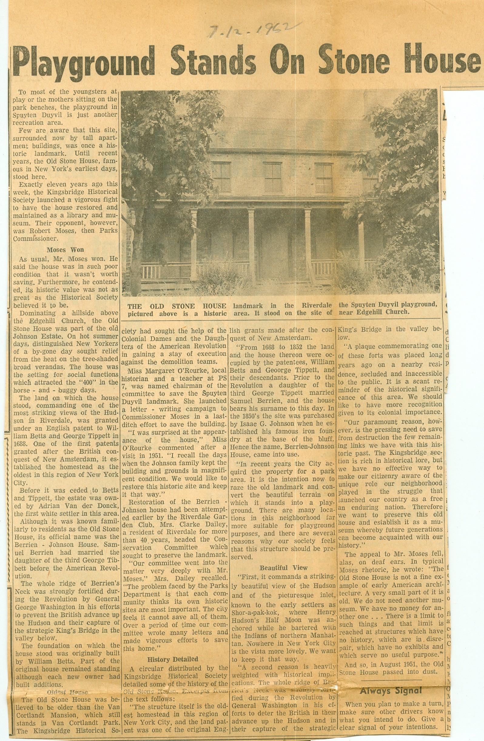
 But back to the Johnson/Berrian house–I am struggling to find out information about why it was torn down. It was clearly a beautiful building.
The Riverdale Press newspaper archive that I use to investigate these sorts of things has no issues from 1952 in its collection. Apparently that is the year it was torn down. My understanding is that the Parks Dept. destroyed after the surrounding land became a Park only to build an ugly looking utility shed in the spot where it once stood. I would really like to know what efforts were taken to save it and what was the justification for its demolition.
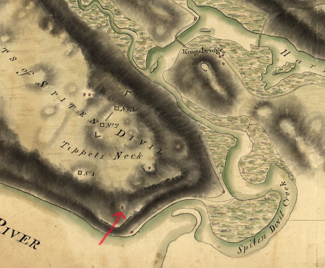
The house predated the American Revolution and it appears on numerous British Intelligence maps. Before the war, it was occupied by Samuel Berrian and his wife Dorcas (Tippett) Berrian. Samuel apparently sympathized with the patriots during war and fled the area after the British took control of New York City. Samuel’s neighbor, Gilbert Tippett, wrote to the local British commanders to ask for permission to seize Berrian’s property while he was with the “rebels” and Gilbert was given permission to use Berrian’s farmland. After the war, Gilbert Tippett, a loyalist, fled to Nova Scotia with other New York loyalists and the Berrians returned to their old house and farm. Before the war, Spuyten Duyvil Hill was commonly referred to as Tippett’s Neck since the Tippett family owned nearly all of it. After the war, it was renamed Berrian’s Neck.
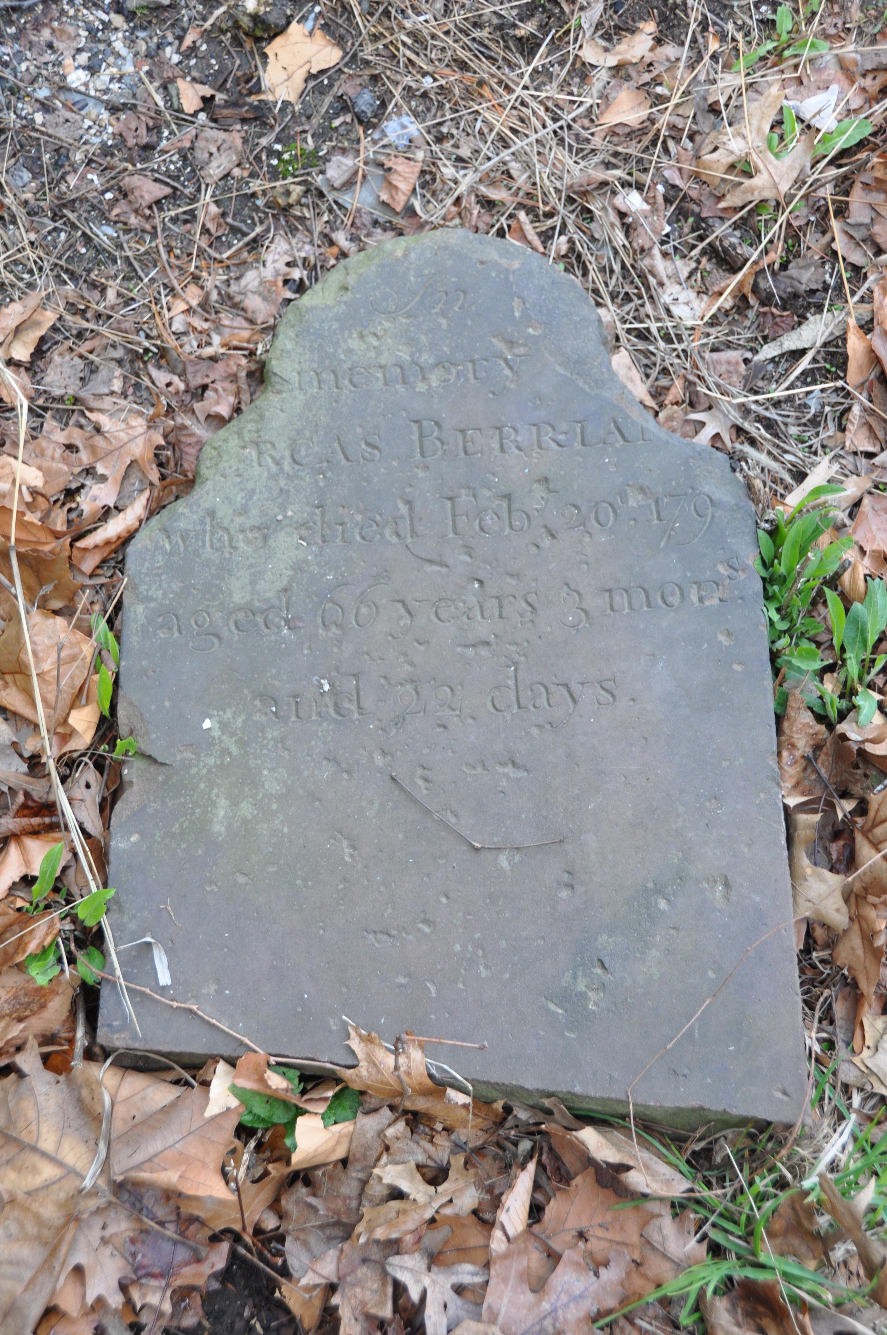 Samuel and Dorcas lived until the 1790s on Berrian’s Neck. Their descendants lived in the Kingsbridge area well into the 20th century. Samuel and Dorcas were buried in the Kingsbridge burial ground (aka Tippett/Betts) burial ground in today’s Van Cortlandt Park. Their headstones were removed from the cemetery sometime in the 1980s and lie on a tarp behind the Van Cortlandt House Museum. Between the destruction of the Berrian house and the removal of the headstones, the Parks Dept. has not been too kind to the Berrian legacy!
The house later became the home of the Johnson family, who owned the Johnson Iron Works. I imagine they were the ones that made the Victorian additions to the house.
Given that historic significance, I have to imagine the KHS resisted the house’s destruction. However, I cannot find any records or articles about it. I am wondering if anyone can dig up something to share.
-
July 1, 2020 at 10:24 pm #1505
The force behind the destruction of the Berrian-Johnson house was Robert Moses. Moses had many hats two of which gave him the power to destroy the B-J house. He was the head of the Triboro Bridge and Tunnel Authority and Parks Commissioner. As I understand it his first effort was that the house was in the way for a reconfiguration of an exit from the Henry Hudson Parkway. The other was expanding of Henry Hudson Park. The Kingsbridge Historical Society under its President and founder, Rev.Dr. William Tieck, engaged Robert Moses in requests to save the Berrian-Johnson house and protest. One request was to save the house and use for both Parks Dept use and as a museum for local history by the Kingsbridge Historical Society. It should be noted that the KHS was the only historical society in the Bronx as the Bronx County Historical Society was not founded until 1955.
The KHS’s effort failed and the building was destroyed in 1952.
This is not a unique decision by Robert Moses. When they were building the New England Thruway entrance from the Hutchinson River Parkway the original plans by Moses would have been built directly through the location of the historic Split Rock. Eventually Robert Moses was pressured to change his plans and moved the Exit off the Hutchinson Pky to the New England Thruway. The exit was moved a few yards to the East leaving the Split Rock isolated on a piece of land between a busy exit to the NE Thruway on the west and the Hutchinson River Parkway to the East making it had for anyone to find and visit the historic Glacial erratic and Native American site.
Regarding copies of the Riverdale Press early editions, the KHS has the early decades of the Press in bound book copies but unfortunately with the pandemic the KHS archives are not accessible at this time.
-
July 1, 2020 at 10:37 pm #1506
Great article, Nick. Thanks! So this house stood near the baseball field in the lower half of Henry Hudson Park, where there’s now a utility shed?
-
July 2, 2020 at 1:55 am #1508
Nick & Peter,
I read from some newspaper, that Parks…” Robert Moses” wanted swings & sprinklers and bathrooms etc
for the ” Community ” He stated that the building was in ruin, to expensive to repair and no important historical event ever happened there. His opinion, backed by a few mothers and children. So sad.
TX Casey
-
-
July 1, 2020 at 11:42 pm #1507
Thanks for the info, Peter. That would have been a real game-changer for local history–to have that house as KHS headquarters. My mother was born in The Bronx in the 40’s and she has VERY strong feelings about Robert Moses (mostly about the Cross Bronx Expressway). Yet another reason to be angry at Moses.
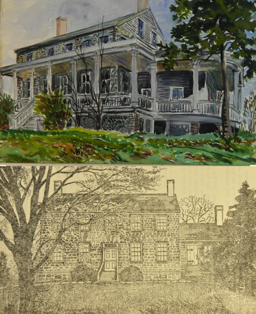
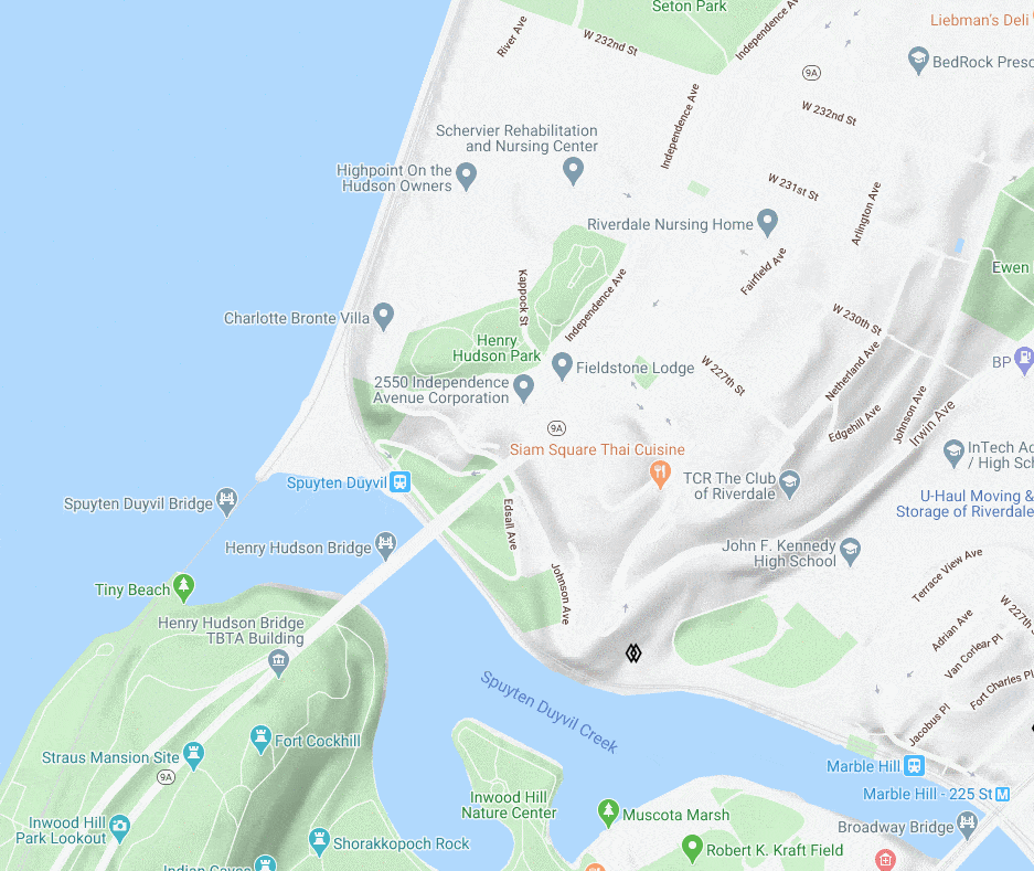
Yes, my understanding is that the house stood where there is now a utility shed/bathroom building by the baseball field. The below animation shows where it was. There is a contemporary Google map there showing the park, an 1885 map with the Johnson house labeled, and a map that I made depicting the area during the Revolution (The red square on the map represents the Berrian House).
If you want to fool around with my map program the link is here (although it is still a work in progress).
Here you can see the house on a map from the Revolution that is in the collection of the Library of Congress:
-
September 28, 2020 at 9:54 pm #1648
I finally know how the Berrian/Johnson house of Spuyten Duyvil met its fate. Thank you to Tom Casey for sharing this article. It sure would have been nice to have this house for KHS headquarters. After all, we are chartered as a museum in New York State. But unlike some other museums you may know of–we don’t have a building!
One thing I wonder is how the author figured that this house was originally built by William Betts.
-
September 28, 2020 at 10:49 pm #1649
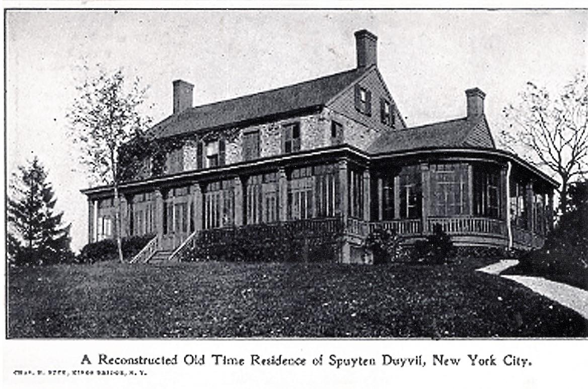
I double checked my files, after re-reading the article….I found a copy of a “Charles Buck ” postcard that I forgot about ” A Reconstructed Old Time Residence of Spuyten Duyvil. New York City ”
-
November 26, 2020 at 8:09 pm #1762
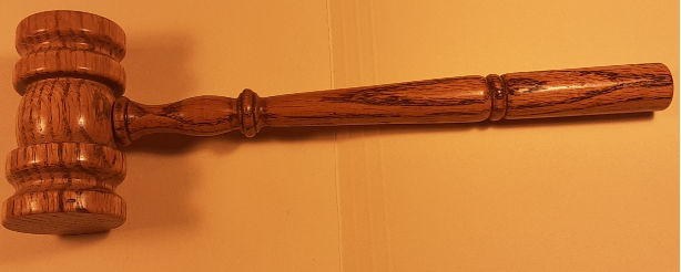
Regarding the old Berrien-Johnson house. The only known artifact that I am aware from the old Berrien- Johnson house is a oak gavel made from one of the beams from the house. The gavel was made for the Kingsbridge Historical Society I believe by George Younkheere a founding member of the KHS and owner of a lumber store that was once located about 235th and Bailey Ave. The gavel is part of the KHS archives.
-
August 6, 2025 at 8:55 am #4869
I’m so glad I found this site!
I am a descendant of the Berrian family!
My great great grandmother was Susan Berrian who married Evert Snedeker.
Can’t wait to find out more about my ancestors!!!
Thank you!
-
August 6, 2025 at 4:59 pm #4870
I have a memory of walking with my Father down to the Younkheere Lumber Yard at 3320 Bailey Ave, which is where ChatGPT says Younkheere’s was located in 1946, in order to get a few 1 x 8 x 8 ft boards that he needed in order to make built-in book shelves for the livingroom of our apartment at 4652 Manhattan College Pkwy. It was a long walk back with me carrying one end of the planks, with the middle of them undulating up and down in sync with our steps…hard work for a 10 year old. We rested often. That was my first experience interacting with a lumber yard. It was sufficiently interesting that I still can picture the inside, cavernous to a boy. I can almost remember the smell.
I appreciate the history in this topic. Thank you, Nick.
-
August 6, 2025 at 9:34 pm #4871
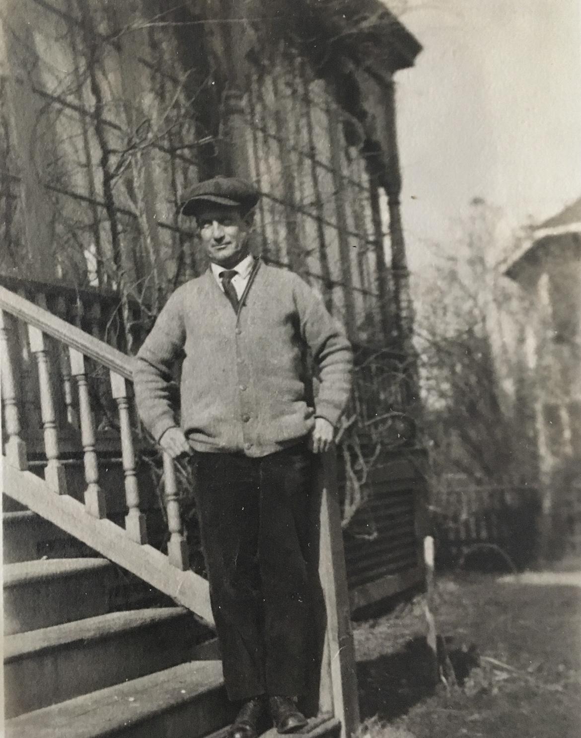
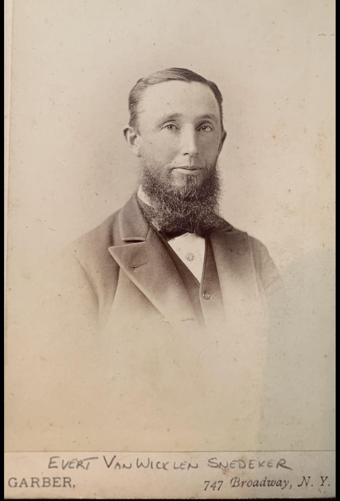
I have a picture of my great great uncle, Every Berrian Snedeker standing on the steps of the house in the early 1900’s. How can I post it?
-
-
August 6, 2025 at 9:35 pm #4872
*Evert
-
August 7, 2025 at 7:01 pm #4873
sfp1979, you can type your message and then click on the last icon in the task bar above the area you wrote in (the icon that has the box with the mountain range and moon). That will open up a box in which you click on the camera icon. That will open up File Explorer for your computer (I’m assuming that it is stored on you computer). Click on the file that has the photo. That location will then be automatically pasted into the rectangular box next to the camera icon. Then click “OK”. I think that that will work for you. I’ll keep my fingers crossed 8^)
-
August 8, 2025 at 8:46 am #4875
Thank you!
-
August 8, 2025 at 8:51 am #4876
Here’s the picture! I hope it worked! Thanks again jbakerjonathan!
-
August 8, 2025 at 9:50 am #4877
I’ll do a little detecting…this is a photo taken in the afternoon of an early Spring day of your great-great uncle in his 40’s around 1925. How’d I do? A wild guess as to his height and weight…5” 8”, 150lbs.
A handsome man. What did he do for a living? -
August 9, 2025 at 9:52 am #4882
Hi!
Thank you!
I don’t have any info about when the picture was taken. Your guess seems very accurate! He was born in 1871 which would put him at 54 in 1925. The Snedeker family were horse people. He was a horse trainer. His father, Evert Van Wicklen Snedeker(who married Susan Berrian), was a famous horse owner and trainer. His father died in 1899 after he suffered a heart attack at the Morris Park Racecourse . They both went by the nickname Eph. -
August 9, 2025 at 11:15 am #4883
Some of the trackmen at the Morris Park Racetrack 1890’s
-
August 9, 2025 at 12:18 pm #4884
Wouldn’t that take the cake if Thomas’s photo has Evert Van Wicklen Snedeker in it! That elderly gentleman standing on the left could be in his late 50s, early 60s, I would guess.
-
August 9, 2025 at 9:25 pm #4891
That’s a great photo, Thomas! Thank you!
It would be something if that was him! The age would be right, but can’t really tell from the profile! I only have one picture of him and it’s from around 1880. I will share it. Many generations, including my grandfather, lived in a house at 2129 Glebe Ave. That house is gone now, too. Getting back to the picture I added, do we all concur its the Berrian-Johnson house he is standing in front of? -
August 9, 2025 at 9:37 pm #4892
Here’s the picture of Evert(Eph) Van Wicklen Snedeker…Might just be him based on the facial hair!
-
August 10, 2025 at 11:00 am #4893
When we compare your photo with that of Thomas’s postcard picture I would say that they are not the same house. I compare the number of columns from the end of the house to the steps, four in the postcard picture (including the one right at the steps) and three in your photo. Also, comparing the capitals at the top of the columns we can see different designs. Further, there are decorative fillets where the columns meet the roof in your photo that are not there in the postcard picture. I think that the house in your photo is not the Berrien-Johnson house.
-
August 10, 2025 at 11:03 am #4894
I see a possible similarity between the right ears of the two gentlemen. Beyond that, there isn’t enough detail to say for sure.
-
August 10, 2025 at 3:52 pm #4895
I know the house was renovated with Victorian touches. That could explain the decorative touches meet the toof. As far as the posts, it could be the angle or a reversed image. My dad was a baseball player and I have one photo that portrays him as batting as a lefty and he was a righty.
-
August 10, 2025 at 4:24 pm #4896
What you posit could very well be true! Two things: do we know the date of the postcard picture and (I don’t know if it matters) do we know the orientation of the house relative to the compass? The lighting of the picture indicates relatively strong sunlight. Was it morning or was it late afternoon? A mystery 8^)
-
August 10, 2025 at 9:06 pm #4903
I’m guessing we’ll never know, will we…unless we find more pictures of the house before it was demolished. In my photo, you can see a building next door. That is also a good clue!
-
August 11, 2025 at 1:07 pm #4904
Could this be the Berrian-Johnson house in this 1924 aerial photo?
-
August 11, 2025 at 2:10 pm #4905
Disregard my last posting. It’s the wrong house.
-
August 12, 2025 at 2:59 pm #4914
I visited the Historical Society yesterday and learned the exact location of where the house stood, thanks to Nick!!! Great meeting you, Nick!!!
We then went to the park and saw, first hand, where the house was! That was very moving. I did some more ancestry research over the past day and learned that my 6th great grandfather, Cornelius Berrian, Jr., was this Samuel Berrian’s brother. -
August 12, 2025 at 4:25 pm #4915
A hop, skip and jump away from KHS in Henry Hudson Park? Glad you found where the house was. Were you able to determine the orientation of the house with regard to the Hudson River?
-
August 12, 2025 at 7:21 pm #4916
Thanks! We were able to get the gist of it, especially after driving around for almost an hour looking for a spot to park!!! Once inside the park, we knew where the Hudson was in relation to the house, but with so many tress, you couldn’t see it!
-
August 12, 2025 at 7:35 pm #4917
I would guess that when the house was first constructed, many trees may have been felled or perhaps (not likely) there was only brush then. I’m glad you had that experience. I’ve taken it upon myself to visit the various graves of my relatives throughout the States…a somewhat weird endeavor, for sure! I’ve even found the building lot where my father, together with my grandfather, build a home in Harlan, Iowa. I have a picture of him with his family standing before the unfinished house, him being 10 years old at the time. I understand your feelings.
-
August 13, 2025 at 8:42 pm #4918
The Johnson-Berrian house was situated where today’s park house is located. It was facing south looking over the Harlem River into Inwood and Manhattan and with a sweeping view of the Hudson River at the right and New Jersey palisades. The only remanent of the house is an oak gavel that the KHS owns. I post a photo of the gavel in the forum while ago. If I find a copy I will post it here.
Regarding tree about the house. During the American Revolution just about all trees on Inwood hill and Spuyten Duyvil hill were cut down. This was done for two reason, fire wood and lines of sight so each fort could see each other and view troop movements. The house being pre-Revolutionary its surroundings were denuded of all trees.
-
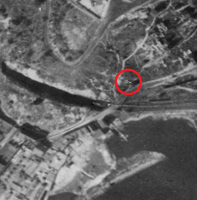
August 14, 2025 at 9:18 am #4919
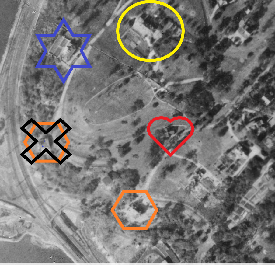
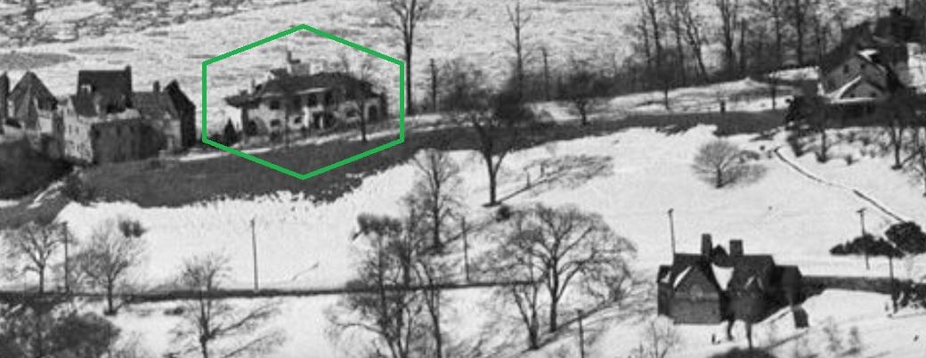
Thank you, Peter. Would this 1924 aerial photo show the Berrian-Johnson house (circled in yellow)? The resolution prohibits greater detail, but it seems that the house is facing the East River and Inwood. It also seems to show an large cleared area in front of the house, giving us an idea of what a denuded expansive view the area would have had in the Revolutionary Period. Edgehill Church is in the red heart showing the two locations relative to one another described in the article in post #1648.
The Villa Rose Bonhuer, newly constructed, is shown in the orange hexagonal, I think.
I have no idea what the building in the blue star was. It might have been located at what is now 2521 Palisade Ave which was built in 1986 (according to NYCityMap site).
Your post #1762 above has the photo of the gavel.
Regarding the photo of sfp1979’s great great uncle, Evert Berrian Snedeker, I believe that the negative was NOT reversed. The cardigan sweater shows the left overlapping the right (the button holes on the left flap, the buttons on the right flap) as is the custom for men’s clothing. There doesn’t appear to be any buildings close to the circled house that would match that seen in the post #4876, either. I don’t think that that photo is of the Berrian-Johnson house.
-
August 14, 2025 at 11:24 am #4920
Correction of location of Villa Rose Bonheur. My apologies.
 .
. -
August 14, 2025 at 10:04 pm #4921
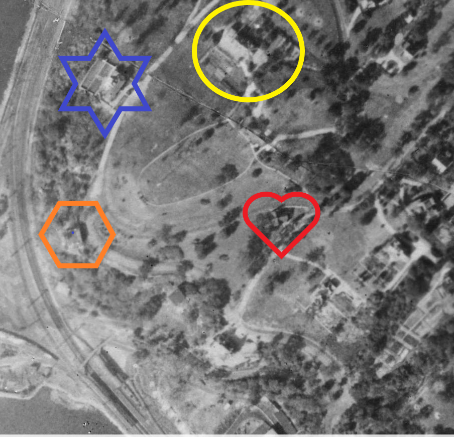
Hi Jonathan.
Here is another angle of that corner of Spuyten Duyvil. This is a 1940 aerial view:
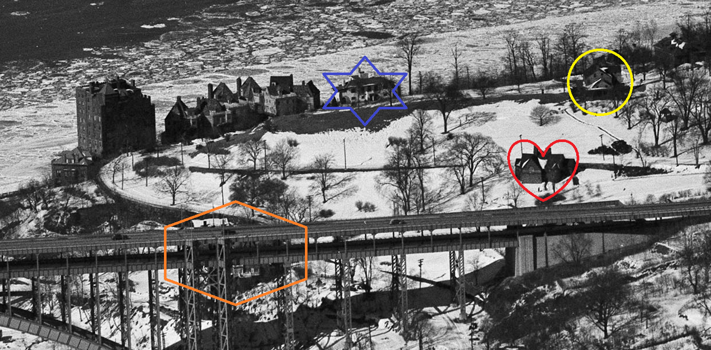
I used your shape/color scheme:
red heart = Edgehill Church
blue six-pointed star = Palisades Ave house
yellow circle = Berrian-Johnson House
orange hexagon = Villa Rosa Bonheur (obscured by bridge)
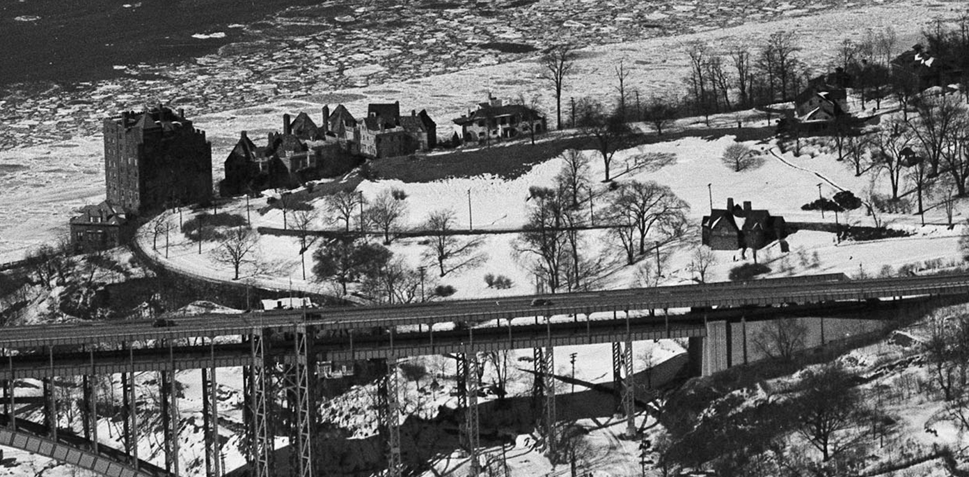
Here it is with no annotation:
I wonder how many people lived in this area at that time vs. now.
Here is a view of the house on Palisades just to the north of the Charlotte Bronte. I don’t have a date on this.
I too believe that the photo in post #4876 might not have been taken in front of the Berrian-Johnson House. But it could have been taken in front of another house belonging to the Berrians in the neighborhood. The Berrians had multiple houses on Spuyten Duyvil. For a while, the hill was known as Berrian’s Neck. They also had property in Kingsbridge and Fordham. Even the Edgar Allen Poe house on Kingsbridge Road was once owned by the Berrians. They were a big family spread all over The Bronx.
-
August 15, 2025 at 2:15 pm #4922
Thanks for these, Nick. I wonder when the building in your last photo was razed. 2575 Palisade Ave seems to be in its location now and that building was constructed in 1958, according to NYCityMap.
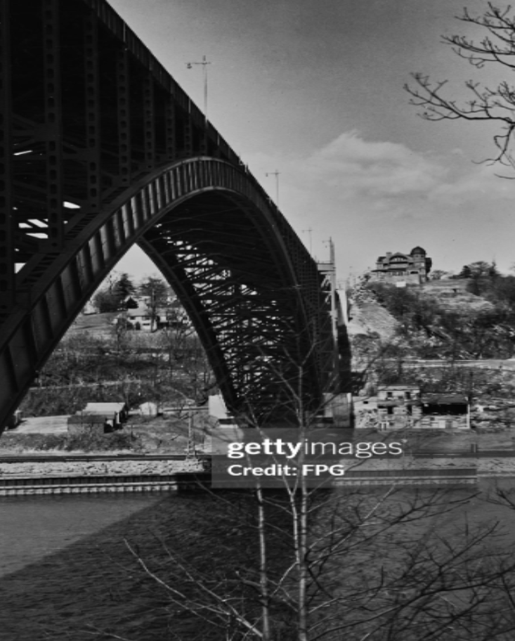
Do you have the link to the aerial photo in your first picture? I’d like to see the building that seems to be just out of frame to the right. I’ll post a photo of it below (circa 1940, Getty Images, credit FPG). Palisade Ave and Edsall Ave can be seen below it (about an inch at this scale). It’s a beauty and I’d like to know its history.
-
August 15, 2025 at 2:56 pm #4923
ChatGPT estimates the population to be between 7,000 to 12,000 in 1940, depending on the boundaries chosen. Intuitively, that seems high.
-
August 16, 2025 at 1:58 pm #4924
When my father started The Riverdale Press in 1950, he mailed vol. 1, no. 1 to 4,000 families, using Riverdale Neighborhood House’s mailing list.
-
August 16, 2025 at 3:46 pm #4928
That’s great, Buddy. The Riverdale Press archives have been so useful for local history that I wish your father started it a decade earlier.
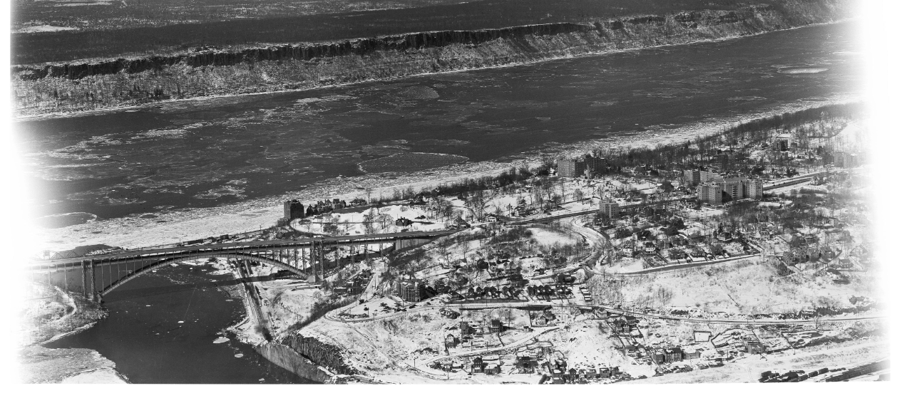
Here is a link to the aerial view in the New York City Municipal Archives, Jonathan. I really like the photo:
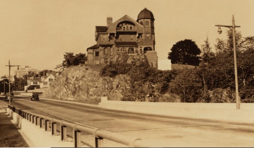
Here is link to a photo of the house you are interested in, Jonathan.
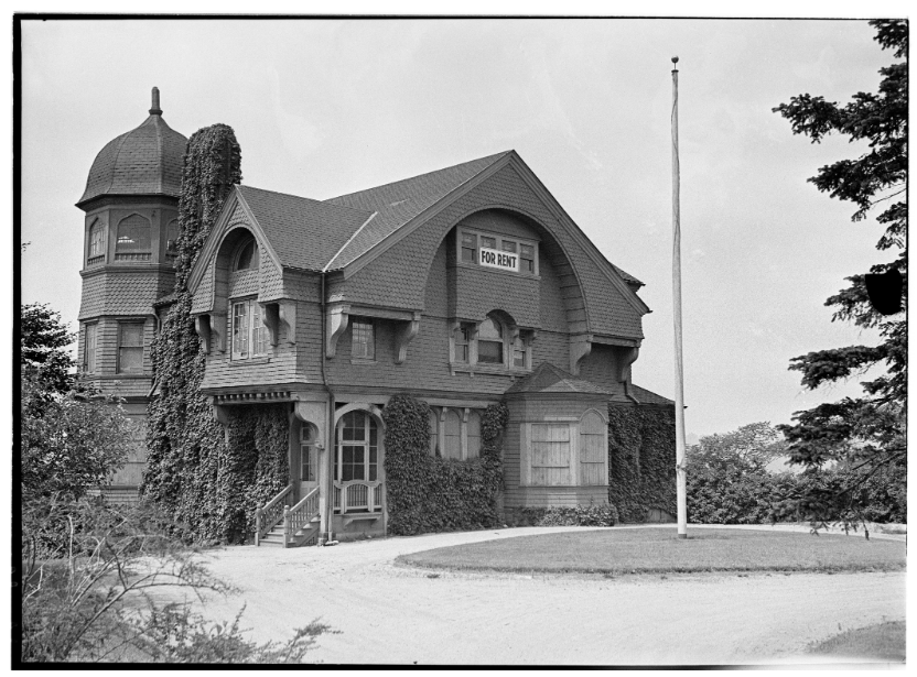
It was a beauty but was torn down not long after the Henry Hudson Bridge was completed. It belonged to the Johnson family although I would have to check our archive to figure out which Johnsons lived there. In the 1850s, the Berrians sold the entire southern half of Spuyten Duyvil to Elias Johnson and the other industrialists that owned the Johnson Stove Works and rolling steel mill. The Johnsons were a big family so they occupied many of the houses on the hill.
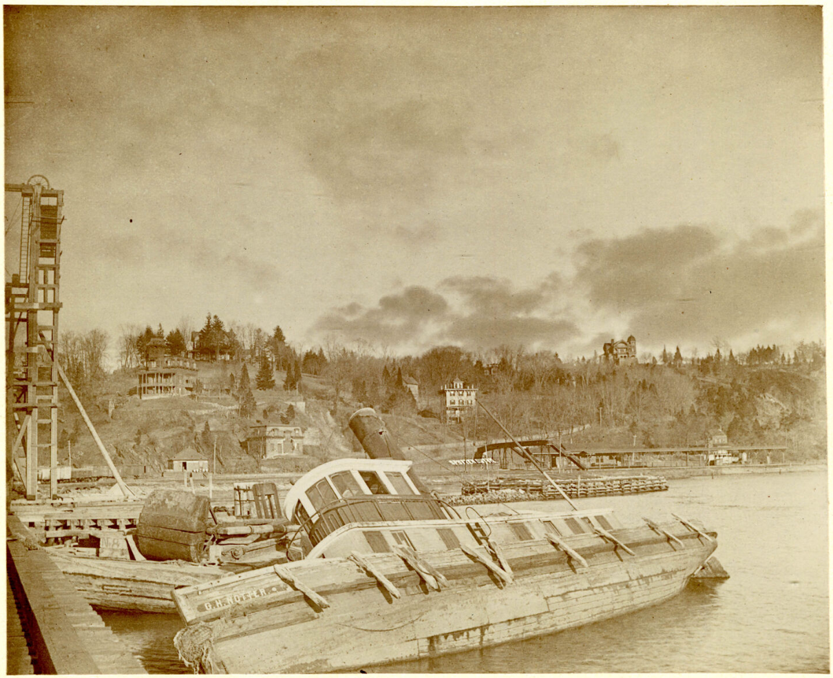
Here is another photo that shows the house (on the crest of the hill, right side) before the Henry Hudson Bridge was built. The view is looking toward Spuyten Duyvil Hill from the Spuyten Duyvil train swing bridge at the base of Inwood Hill.:
-
August 16, 2025 at 6:19 pm #4929
Thank you Nick. From the photo it appears that the structure was razed subsequent to 7/17/1935 and prior to 1/6/1940, the date of the aerial photo (or did I overlook the house in the photo). My photo was dated circa 1940, so it may have been the last photo of the building as it stood in the Fall of 1939, I’m guessing. It looks like the property ended up being a parking lot next to 55 Knolls Crescent in the early 1950s. Sad.
Your second photo apparently was taken around 1902. Close inspection shows the words “Spuyten Duyvil” laid out on the embankment underneath the pedestrian overpass to the train station. I’m sure that they are all gone now, but can you identify any of the buildings on the hill to the left of the station?
I wonder what the story is of the boat the O.H. Notter (or Hotter, as best that I can make out). She doesn’t look seaworthy in the picture, lol.
-
August 16, 2025 at 6:30 pm #4933
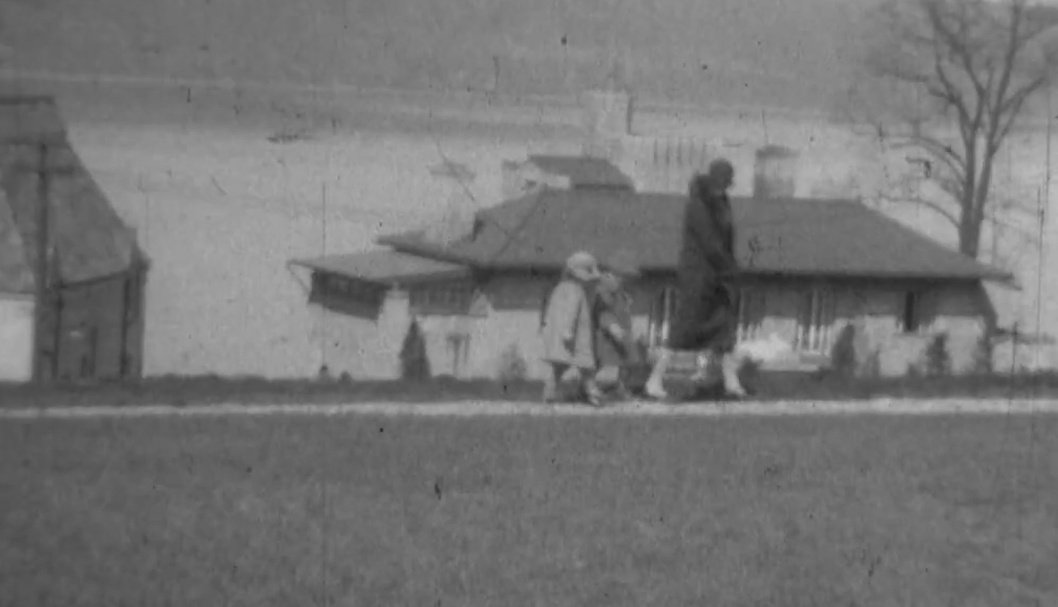
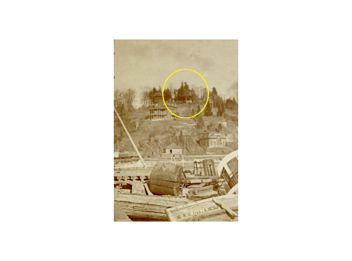
I’m wondering if the circled house is the Berrian-Johnson house.
-
August 16, 2025 at 7:29 pm #4936
Yes, that’s it.
-
August 17, 2025 at 9:14 pm #4940
That’s a great picture!!!
Thanks for sharing! -
August 18, 2025 at 6:38 pm #4953
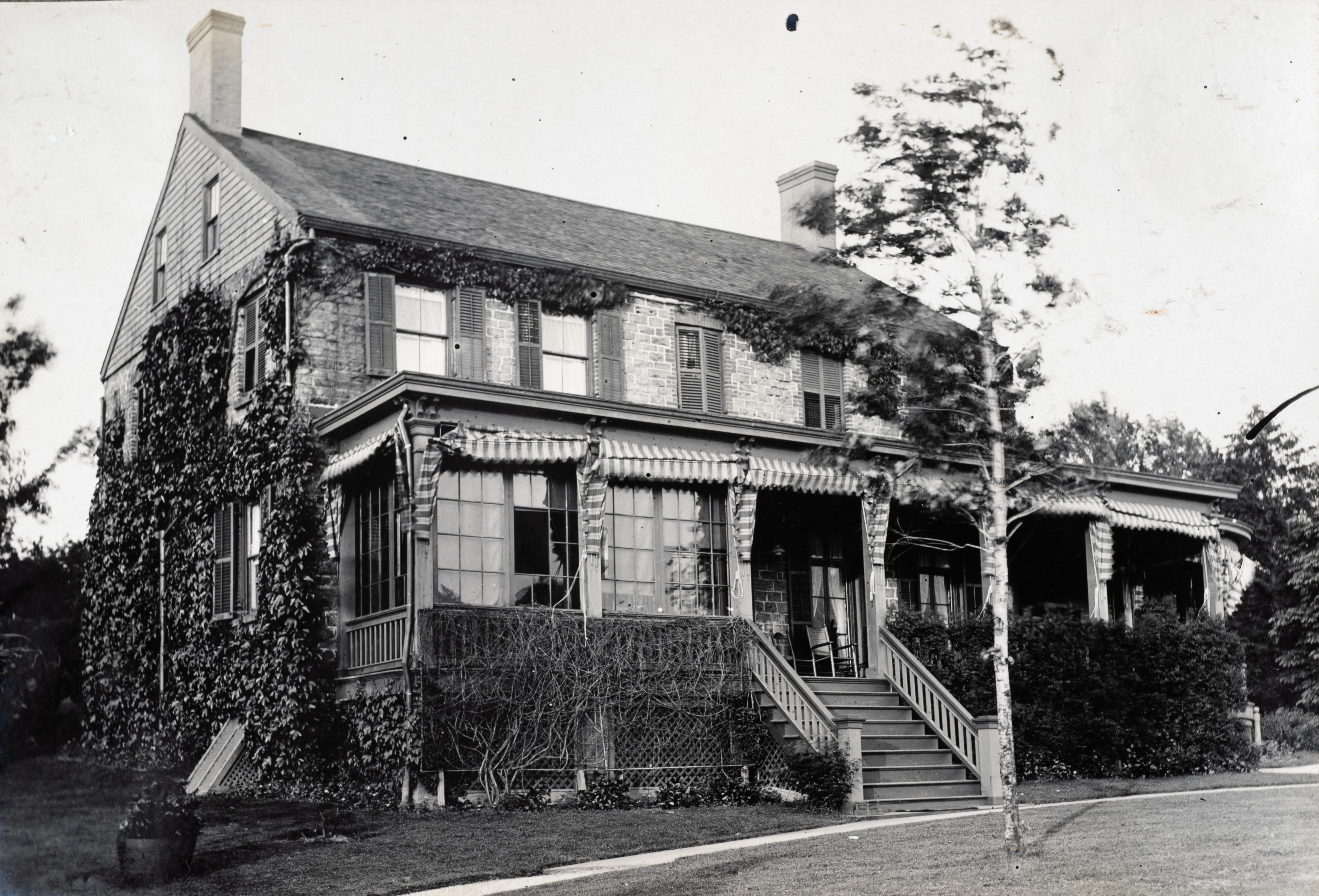
The Old Stone House – from the Johnson’s family album.
-
August 18, 2025 at 6:50 pm #4954
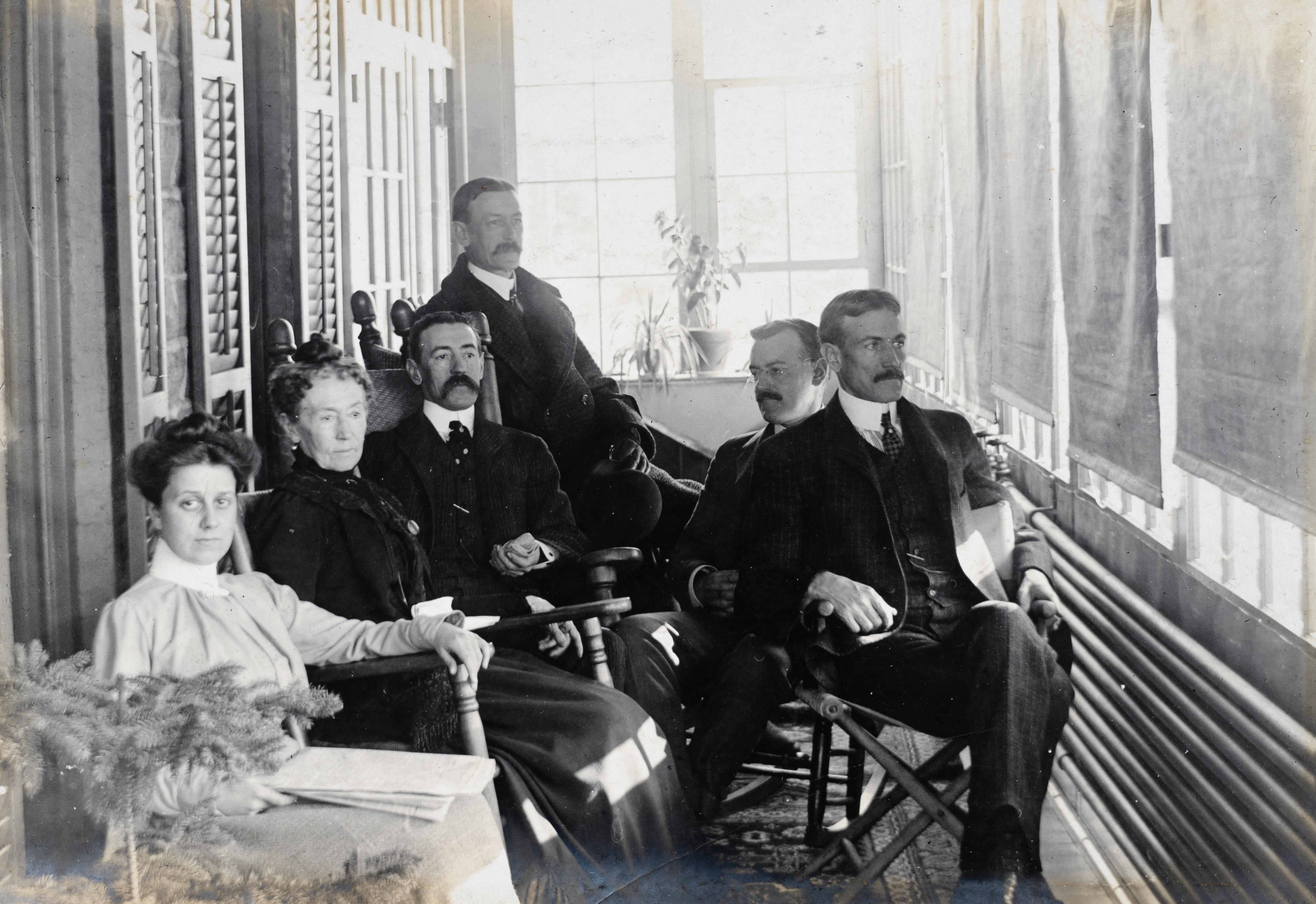
Johnsons enjoyed the Old Stone House’s screened porch on a summer day.
-
August 18, 2025 at 6:53 pm #4955
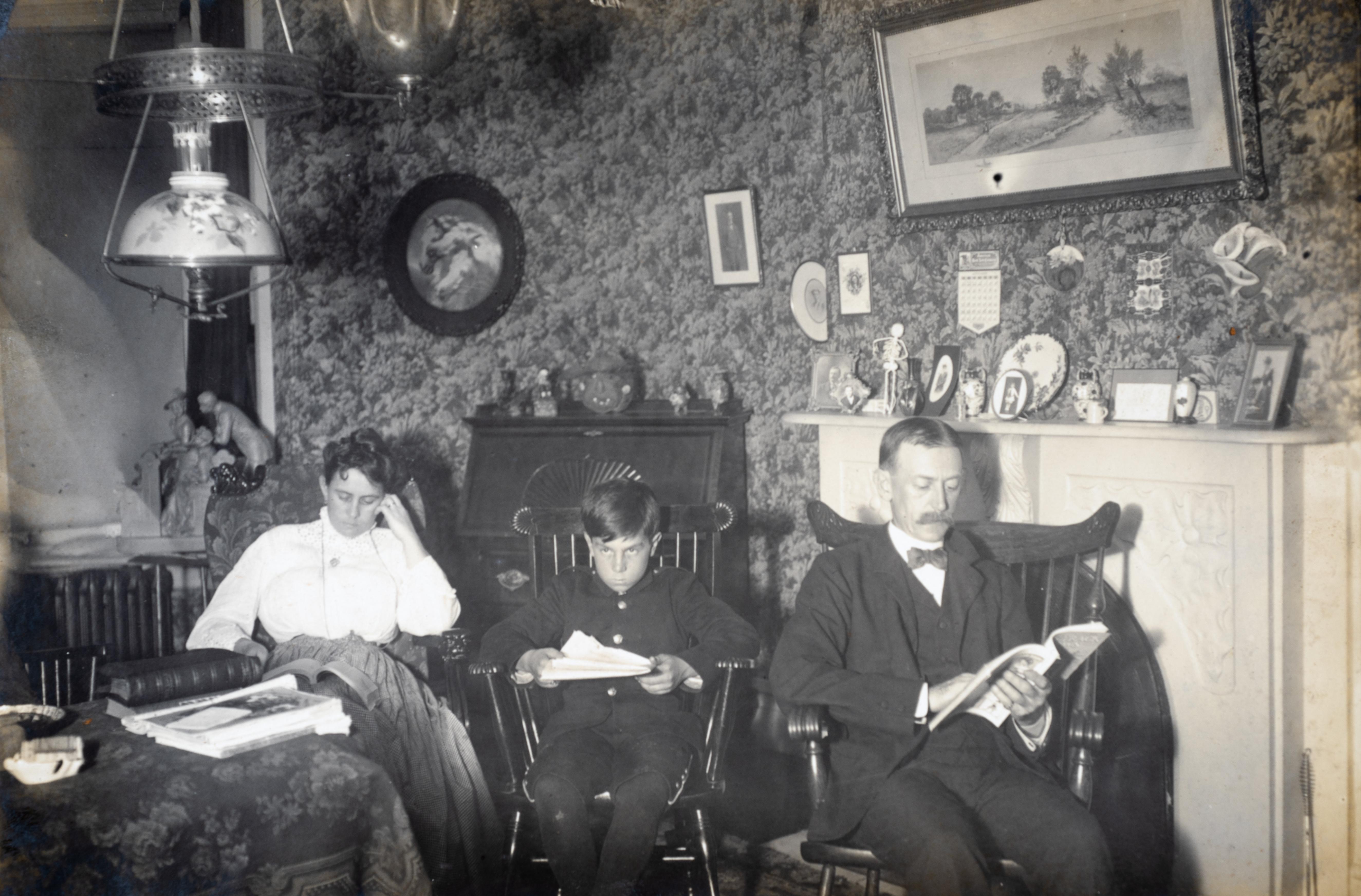
Reading in the Old Stone House Parlor
-
August 19, 2025 at 8:26 am #4956
DWDitmars, thanks for these photos! The Old Stone House gives us a perfect “picture” of what it looked like. Do you have a date for the photo?
The pictures of the family on the porch show how “straight-laced” society was, and how uncomfortable it must have been in the summer without A/C. Moustaches were de rageux for the men as well as suits and ties and high collared blouses and maxi-skirts for the women. I’m breaking a sweat just thinking about it, lol.
-
August 20, 2025 at 7:44 am #4959
These pictures are amazing!
would love to know the dates!
Wish you had some of the Berrians!
Thank you! -
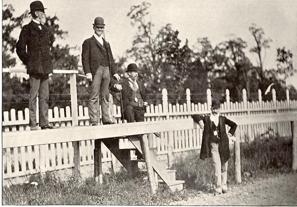
August 26, 2025 at 2:13 pm #4972
The Johnsons
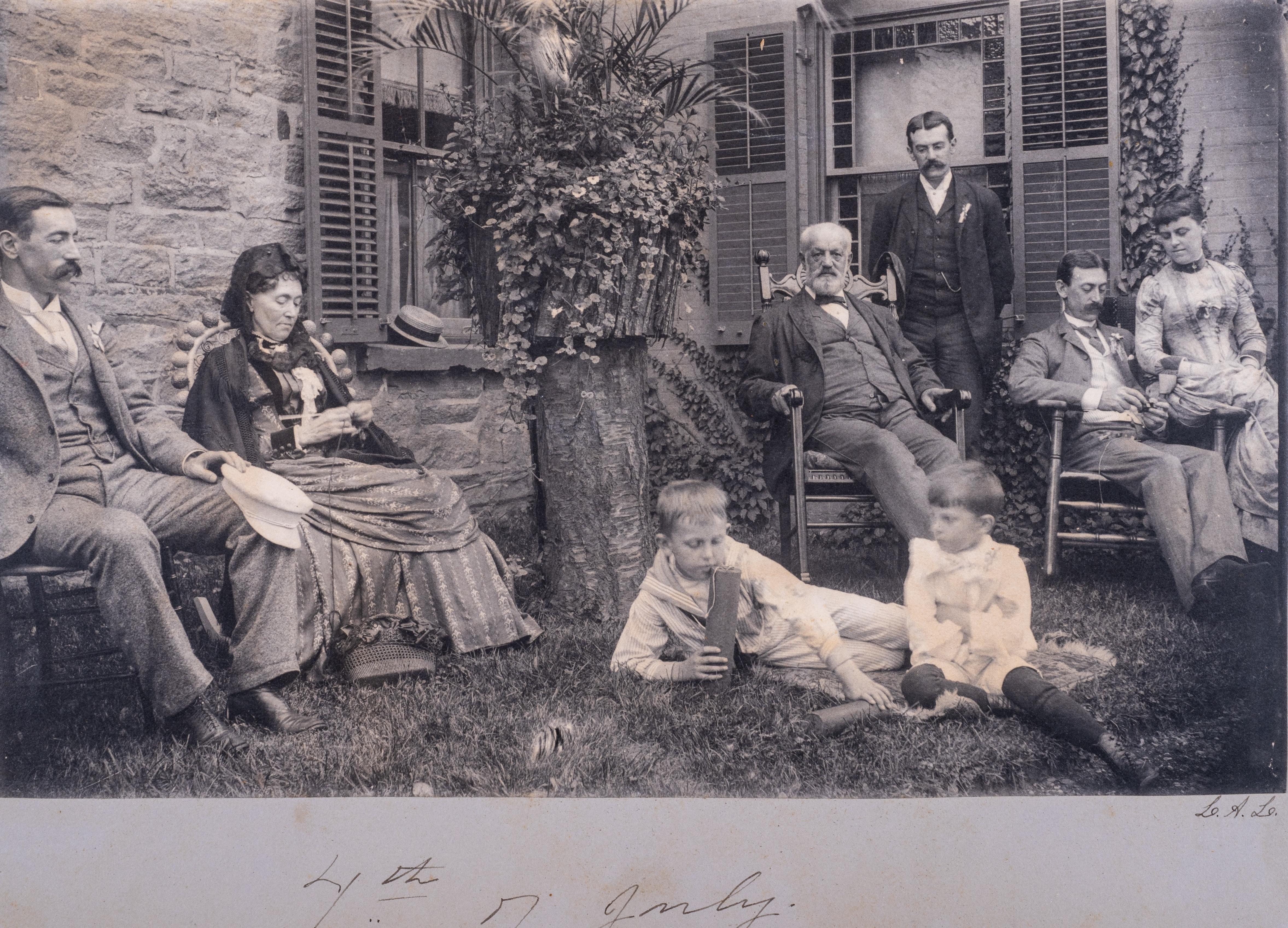
Isaac Gale Johnson and his wife Jane Eliza Bradley enjoyed a 4th of July with several sons and grandchildren outside the Old Stone House. All these Old Stone House pictures are from an album dated 1893 that I inherited from my father Walter E. Ditmars whose mother was Jennie Ann Johnson, daughter of Arthur Gale Johnson.
-
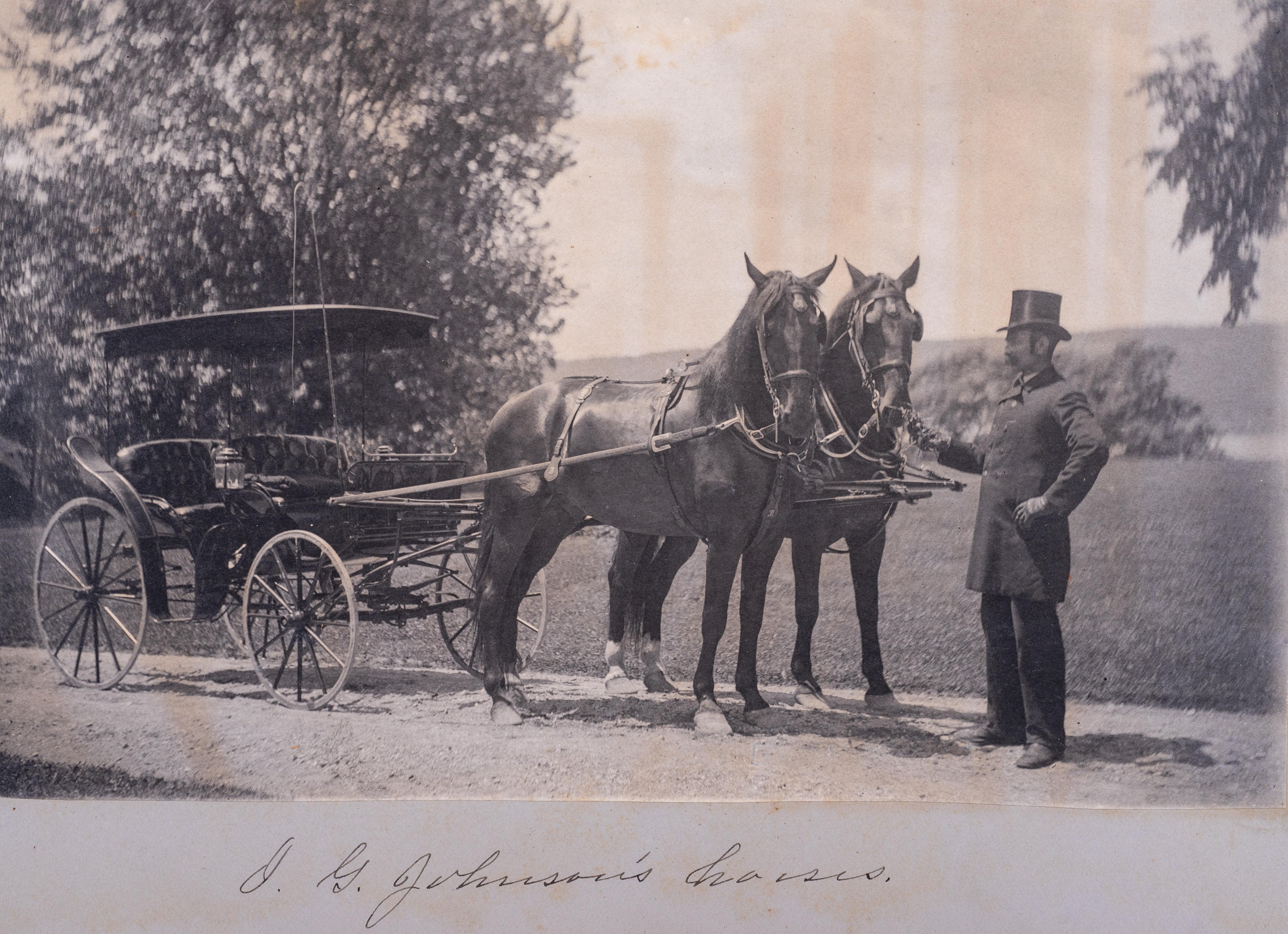
August 26, 2025 at 2:23 pm #4973
Isaac Gale Johnson’s two-horse chaise stands ready for a Sunday drive through the Spuyten Duyvil countryside.
-
August 26, 2025 at 3:00 pm #4974
I just got back from Portland OR so I figured I will add a different View and see if anyone has an idea about the mystery house.
-
August 26, 2025 at 3:12 pm #4975
Thomas, are you referring to the house within the green hexagon? Nick identified the Johnson house that is next to the HHPkwy in the sepia photo. Your photo shows just how beautiful that house was. What a shame that it was torn down and, I think, replaced by a parking lot next to 55 Knolls Crescent.
-
August 26, 2025 at 3:32 pm #4976
Correct
-
August 26, 2025 at 3:39 pm #4977
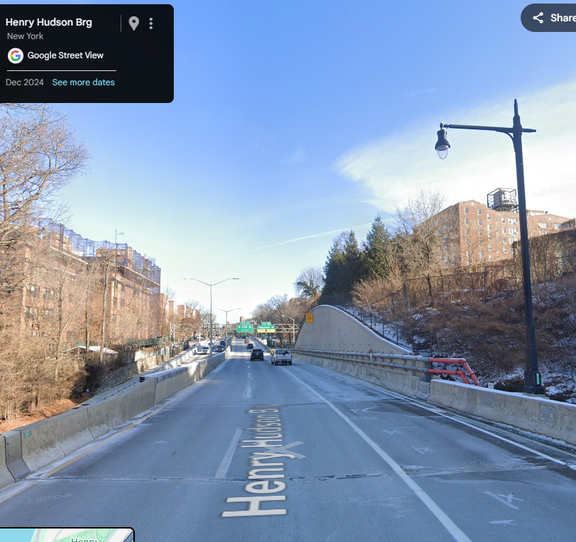
Here is a view taken in December 2024 of where the location of the Johnson house was, with a concrete retaining wall replacing the excavated stone ledge next to the house shown in the sepia photo.
-
-
AuthorPosts
- You must be logged in to reply to this topic.