Home › Forums › The Colonial Era › Kingsbridge Burial Ground (aka Tippett/Betts/Berrian burial ground)
- This topic has 9 replies, 4 voices, and was last updated 3 months, 1 week ago by
Cz403.
-
AuthorPosts
-
-
May 29, 2018 at 8:41 pm #470
Today’s New York Times featured an article, quoting Peter Ostrander and me, about the Kingsbridge Burial Ground in Van Cortlandt Park that you can check out here. For a little extra background, read on.
LOCATION:
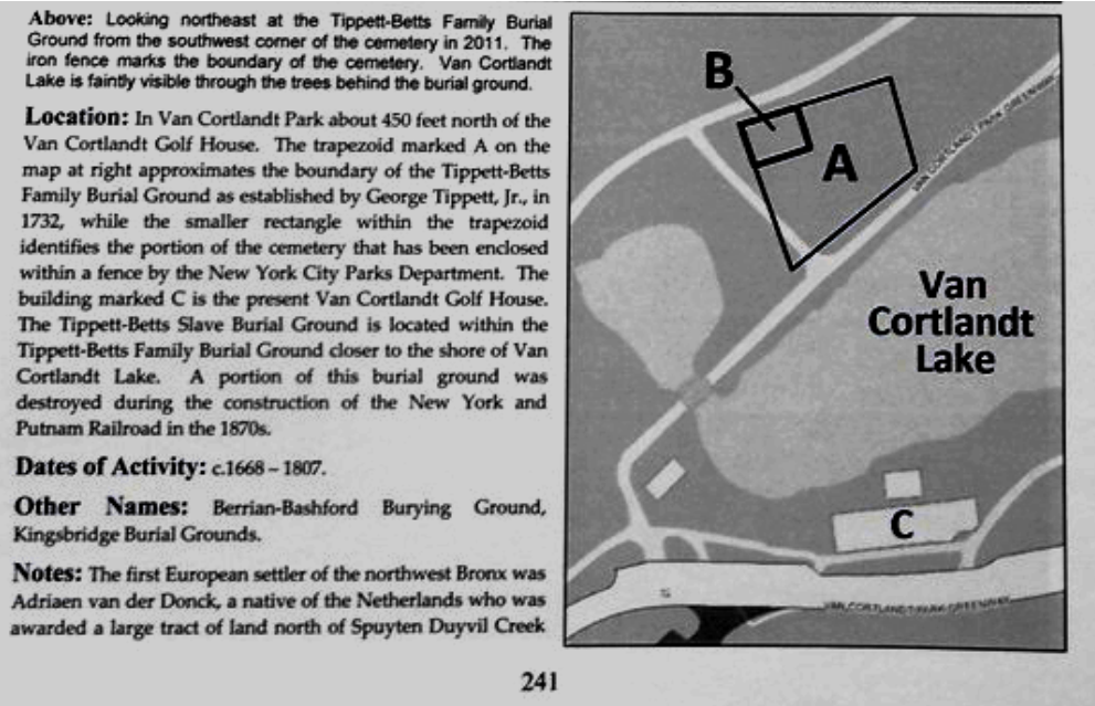
Where was the Kingsbridge Burial Ground? This graphic from Patrick Raftery’s excellent book, The Cemeteries of The Bronx, shows it best. The area marked “A” is is the location of the Burial Ground and the area marked “B” is a fenced off area containing stubs of headstones. The building marked “C” is the golf house. This map of Van Cortlandt Park also shows the location of the burial ground. The above-mentioned Patrick Raftery, librarian at the Westchester County Historical Society, was instrumental in finding documents related to this cemetery.
The Kingsbridge Burial ground is also indicated on this great map by the Van Cortlandt Park Conservancy.
ARTICLES AND PHOTOS OF THE CEMETERY:
Edsall and Jenkins both wrote about the cemetery around the turn of the 20th century.
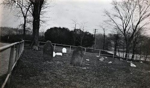
Cemetery in 1910.
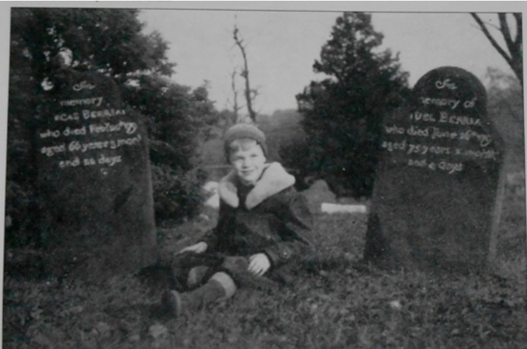
Cemetery in 1936 (photo from Patrick Raftery’s The Cemeteries of The Bronx)
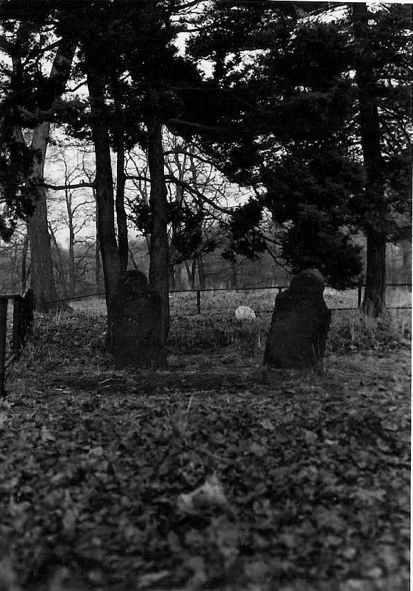
Cemetery in 1971.
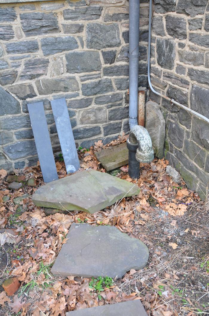
Removed headstones from the above photos behind the office of the Van Cortlandt House Museum
ADJACENT BURIAL GROUND FOR ENSLAVED PEOPLE:
Local historians have long suspected that part of the Kingsbridge Burial Ground was used by enslaved people, who lived in the area in great numbers. The enslaved people were supposedly buried in the area marked “A” in the map from Patrick Raftery’s book. Slavery was prevalent in the area. The earliest recorded census (1698) of this part of The Bronx indicates more enslaved people living in the area than free people. I have been researching slavery in the area and writing about it here.
The following clipping from a 1905 issue of the Mt. Vernon Daily Argus seems to corroborate the oral history in the second paragraph:
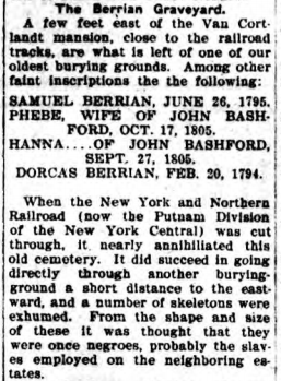
The railroad they were building in the clipping became the rail trail popular with runners and bikers today. I would imagine that most of the cemetery was not disturbed in the construction of the railroad but I cannot be sure. I am trying to get a coalition of local people together who are interested in studying this area. According to an archeologist I spoke with, remote sensing technology could be used to find out if burials lie in the ground. If this site was used as a burial ground for enslaved Africans, it should be marked as such. If you are interested in getting involved please let me know at info@kingsbridgehistoricalsociety.org
WHO OWNS THE BURIAL GROUND?
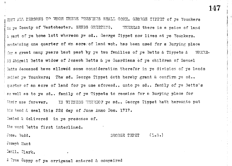
Before the Van Cortlandt family purchased the land adjacent to the cemetery, it belonged to one of the area’s first settlers, George Tippett. As the NYT article states, he declared the cemetery land to be a “Burying place for [his descendents’] use forever.” Below is a transcript of the declaration–Liber E 147 from the Westchester County Land Deeds.
In 1732, he sold all of his remaining land in the area to the Van Cortlandts except for the cemetery. That deed is in Liber G-30 in the Westchester County Land Deeds. So it would seem that the cemetery land should still belong to the descendants of the Tippett family. According to the NYT article, “The Parks Department disputes the claim, saying the city acquired the entire Van Cortlandt estate between 1888 and 1890 by condemning it. “When a parcel is acquired through condemnation,” a spokeswoman for the Parks Department said, “the acquiring party takes title to everything.” I had not seen any references to the land being condemned in any historical documentation and the article does not provide any historical documentation relating to a condemnation. If anyone comes across any records of this, please get in touch with us.
According to Christopher Ricciardi’s excellent thesis about Van Cortlandt Park, “the Van Cortlandt Family deeded their Mansion and sold their land to the City of New York.” He does not mention anything about a condemnation.
-
June 6, 2018 at 1:19 pm #471
Peter Ostrander and I were interviewed for News 12 in The Bronx about the Berrian headstones. See the report here:
http://bronx.news12.com/story/38312232/historic-cemetery-rests-in-pieces-within-van-cortlandt-park
-
June 15, 2018 at 1:13 pm #481
NY1 ran a story about the Kingsbridge Burial Ground yesterday that you can see here:
We are currently in the process of finalizing the draft of our proposals to the Parks Department (for restoring the burial ground, adding signage, etc). I met with several members of the park administration and they seem open to hearing our ideas. I will post their response and any updates here.
-
June 28, 2018 at 12:23 pm #484
When I was discussing the issue of the burial ground with the NY Times reporter, I really wished that I had a map, historical or otherwise, that indicated the existence of the Kingsbridge burial ground–just to prove, beyond the shadow of a doubt, that it had been there. Well, it’s a little late but I did find such a map. It’s the USGS USA topo map:
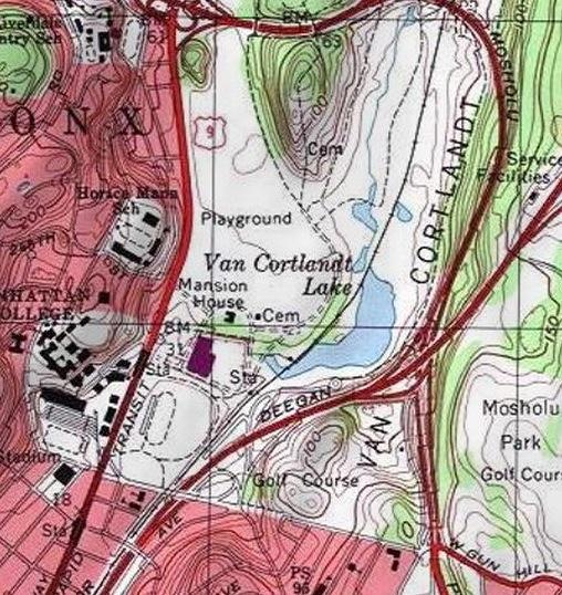
Note the “Cem” indicating a cemetery at both the Kingsbridge Burial Ground to the east of the Van Cortlandt Mansion House and the Van Cortlandt burial vault to the north.
-
November 30, 2025 at 8:47 pm #5075
In doing some research on the American Revolution, I was reading a soldier’s journal and came across something that could relate to the burial grounds in Van Cortlandt Park. The journal was written by a Hessian soldier, who was stationed in the Kingsbridge area (the Hessians were the German soldiers that fought on the British side in the war). In his journal entry for July 2, 1781 he described a skirmish in what is now Yonkers:
“During the skirmish, Brigadier Buttlar was killed. He was buried, together with a Hessian jaeger, near Courtland’s house.”
I would bet that if these soldiers were buried near the Van Cortlandt House in what is now Van Cortlandt Park, that they were probably buried in the Kingsbridge Burial Ground, which is just a couple hundred yards from the house. If that’s true, over the course of the war there could have been many more buried there. There could be American, British, German and French soldiers buried there since all were involved in the fighting near Kingsbridge.
I am going to add this journal (the Journal of the Prince Charles Regiment translated by Bruce Burgoyne) to the list of known documents related to the Kingsbridge Burial Ground.
-
December 1, 2025 at 12:08 pm #5076
Thanks, Nick, for your continuing efforts regarding the cemetery adjacent to the Van Cortlandt house.
I recall reading a description of the ground penetrating radar effort somewhere in the forum. Has it been determined exactly how many bodies are buried within the cemetery?
Has the Parks Department followed through with placing signage during the seven years since your request? Has any city condemnation record been found to substantiate the Parks Department claim to the cemetery grounds?
Has any further efforts of any kind been made regarding the cemetery since 2018? What efforts were made to preserve the headstones that were found behind the VC House?
Regarding the 1936 picture of the boy sitting between two headstones, it appears that the inscriptions were filled with a contrasting paint (?) that cannot be seen in the 1971 picture. Was this possibly due to weathering in the intervening 35 years? Who was the boy? Was he a descendant of the people buried there?
The journal describing the burial of Brigadier Buttler and the Hessian jäger is a good find.
-
December 1, 2025 at 5:37 pm #5077
Thanks Jonathan.
The number of burials has never been determined. We also really don’t know the spatial extent of the cemetery. There is a fence around part of it but it was installed during the 20th century.
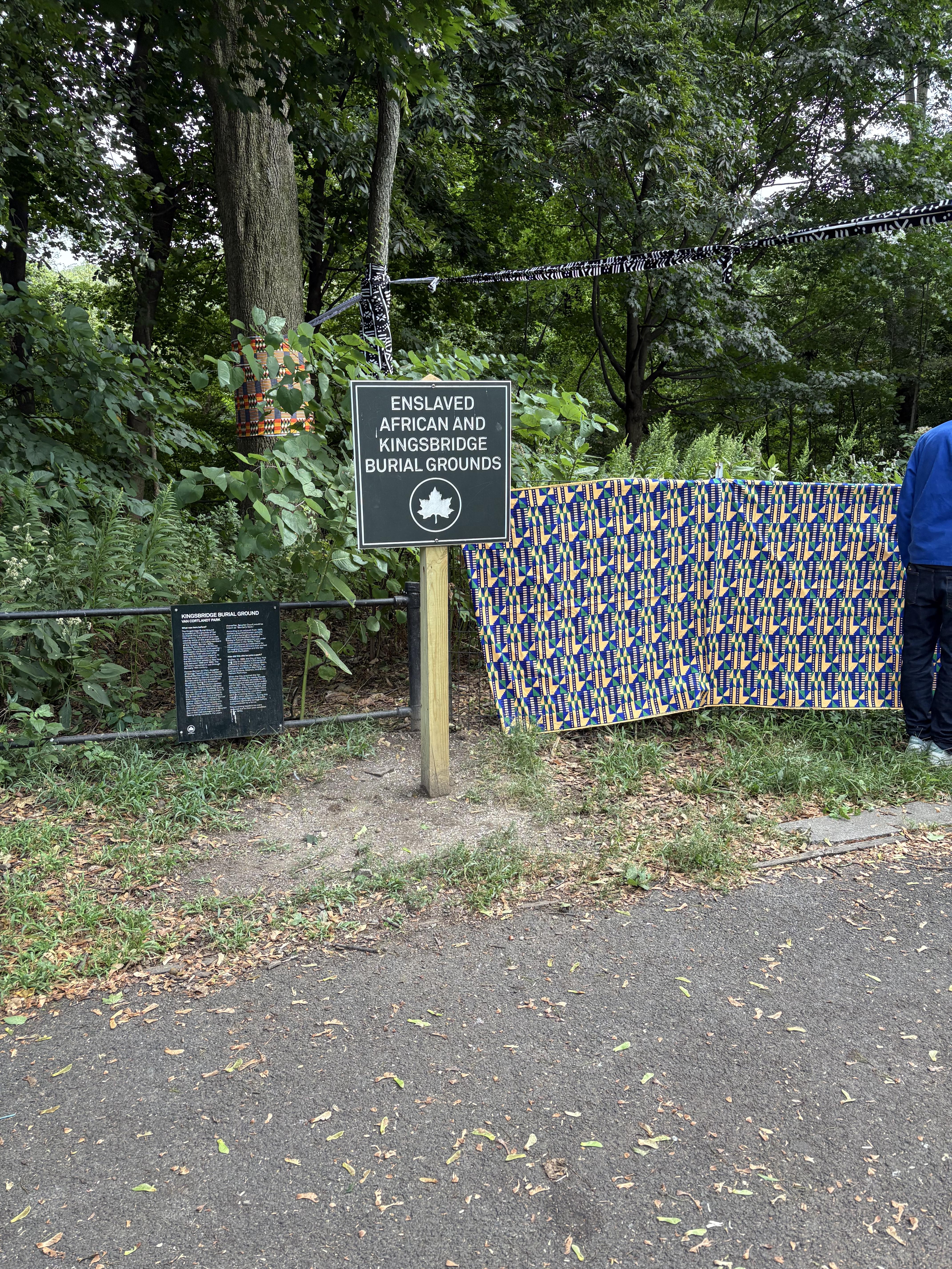
Now there is more than one sign at the burial ground. I’ll take a photo and upload it later.
I have never seen the condemnation record but, if it exists, it would be good to know how it was worded. I believe other Bronx parks were formed after condemnation of the land. I do not know exactly why that was done but perhaps someone else has an idea.
As for the boy in the photo:

His name was Theodore Baumeister III. I first saw the photo (and the boy’s name) in Patrick Raftery’s book on Bronx cemeteries. I tracked down Theodore’s phone number and called him sometime in 2017 or 2018 when he was in his 90s and living in the south. He told me that he remembered the day that his mother took him to the cemetery to take the photo. He was a Berrian descendant and proud of it.
The headstones are now on loan to the Kingsbridge Historical Society from NYC Parks. They were a special feature of our exhibit on the Revolution. The paint or chalk that you can see in the lettering in the photo has worn away but the engraving is still very visible.
-
December 6, 2025 at 7:24 pm #5079
GREAT DETECTIVE WORK! Being a researcher, among other things, I really enjoy what you share of your research. THank you, Susan Landgraf
-
December 7, 2025 at 10:43 pm #5080
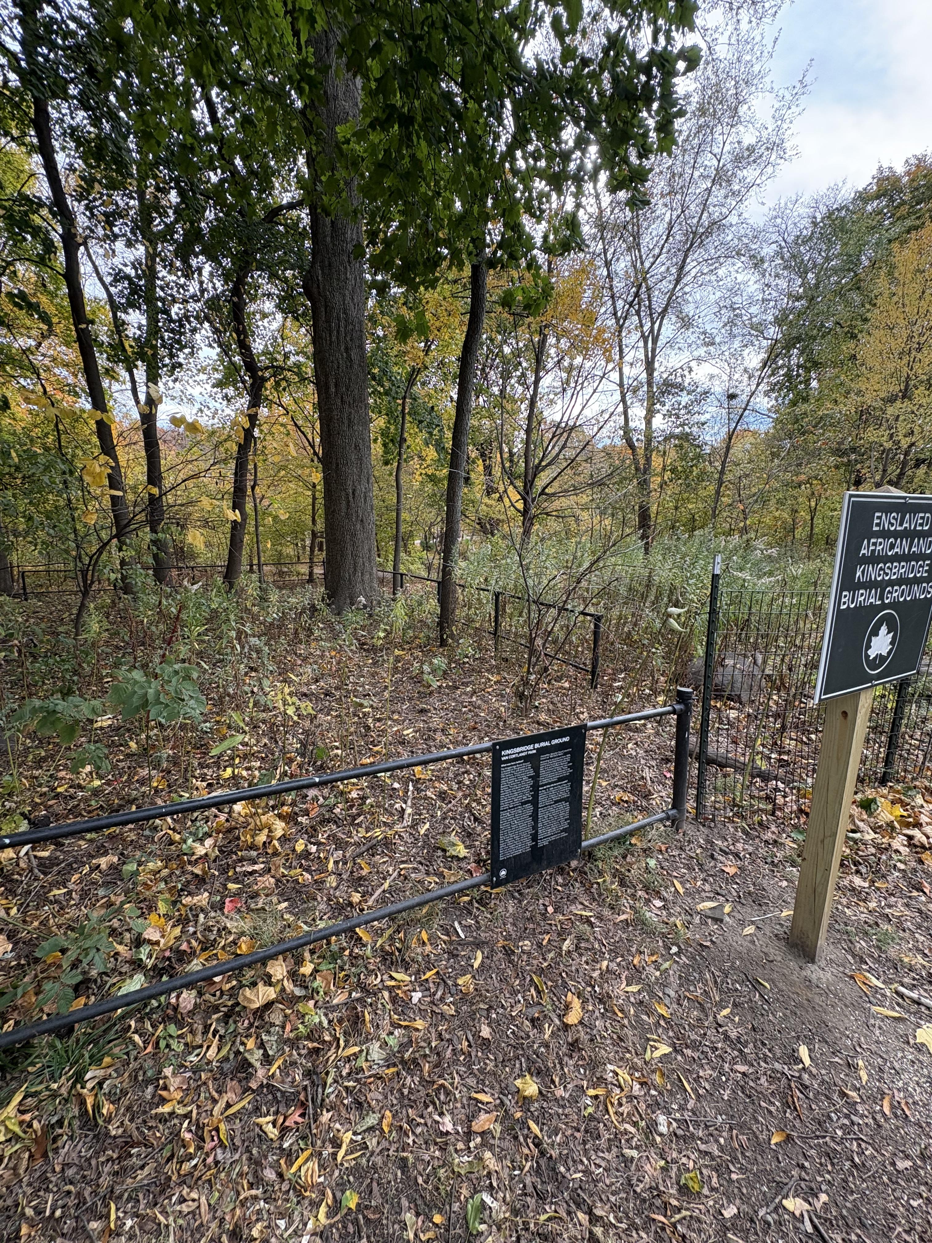 Here are some pictures of the burial ground signage.
 -
December 7, 2025 at 10:45 pm #5081
-
-
AuthorPosts
- You must be logged in to reply to this topic.