Home › Forums › Everything Else related to Kingsbridge, Riverdale, and Spuyten Duyvil › Mystery Marker
- This topic has 19 replies, 5 voices, and was last updated 1 month ago by
Brendan.
-
AuthorPosts
-
-
November 6, 2023 at 8:53 pm #3773
A member sent in this photo and asked if anyone knew what this stone marker is. It is located on the north side of W. 232nd Street west of Independence Avenue in Seton Park.
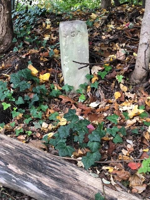
A group of us saw this marker while on the geology walking tour and were wondering about it as well. It is across the street from 740 W. 232nd Street.
-
November 6, 2023 at 9:35 pm #3775
Could it possibly be a surveyor’s monument?
-
November 7, 2023 at 1:50 pm #3776
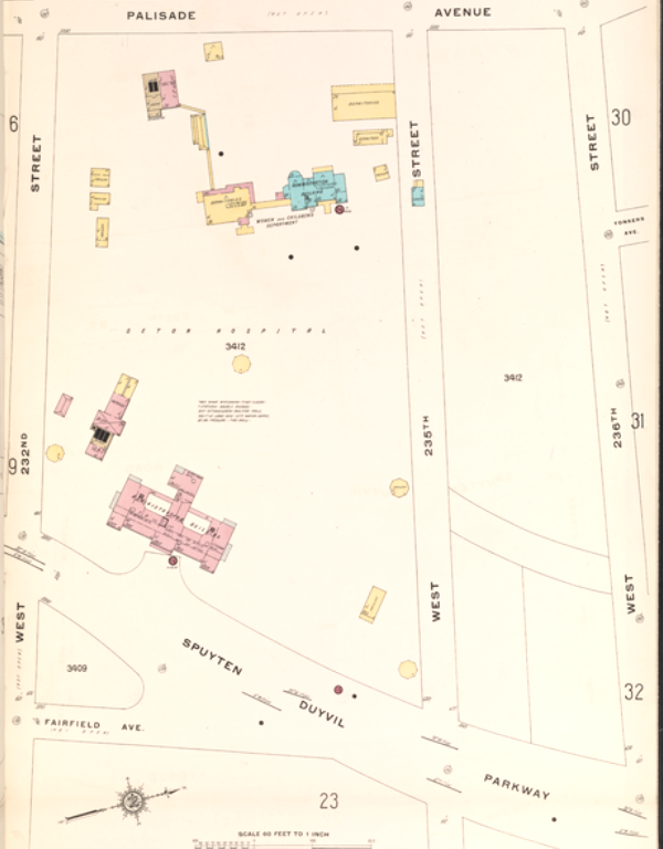
The size is unknown and the distance into the park from the road is unknown. and the distance from the front door of 740 W. 232nd is unknown also. but it was located on the Seton Hospital property. Map of 1914 is attached.
-
November 7, 2023 at 1:58 pm #3777
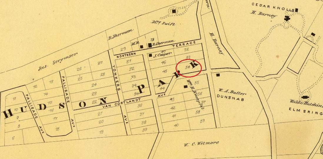
Or the lot marker #54
-
November 7, 2023 at 4:44 pm #3778
It might be a lot marker for the Douglas Estate, as it not far from the Raoul Wallenberg Forest where the Douglas House once stood.
-
November 7, 2023 at 7:41 pm #3779
Would there be a way to superimpose a current map with the map showing lot #54 to give an idea of the relationship of the lot map with current streets? I don’t have that skill.
-
November 7, 2023 at 9:00 pm #3780
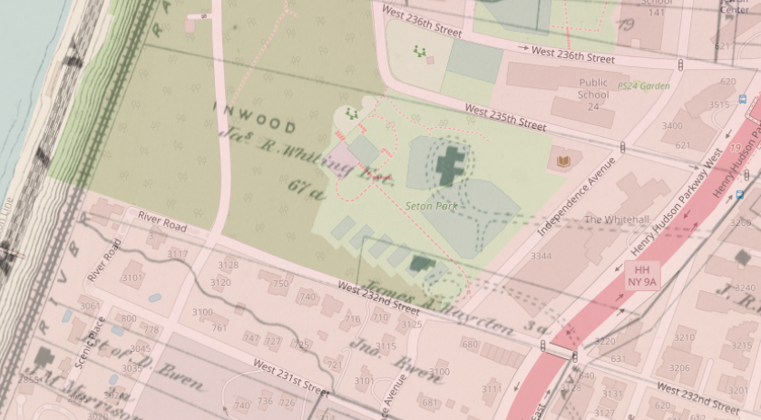
Good idea. Here is a link to the superimposed map (use the blue bar in the upper right corner to adjust the opacity of the 1872 map and zoom on the top left): https://kingsbridgehistoricalsociety.org/images/stone%20marker%20map/openlayers.html
I think it could very well be a property marker of some kind but it is not lot 54 in Hudson Park as shown in the map Tom found, which was apparently north of 236th Street. This marker on W. 232nd seems to be on the property boundary between Judge Whiting’s property and James Hayden’s property.
We discussed Whiting a little in this thread: https://kingsbridgehistoricalsociety.org/forums/topic/the-hudson-river-and-railroad-illustrated/
-
November 8, 2023 at 1:52 pm #3781
The lot marker could have been moved from the Lots at 236th or its possible the lots on west 232nd were assigned similar lot numbers.
-
November 11, 2023 at 9:02 am #3784
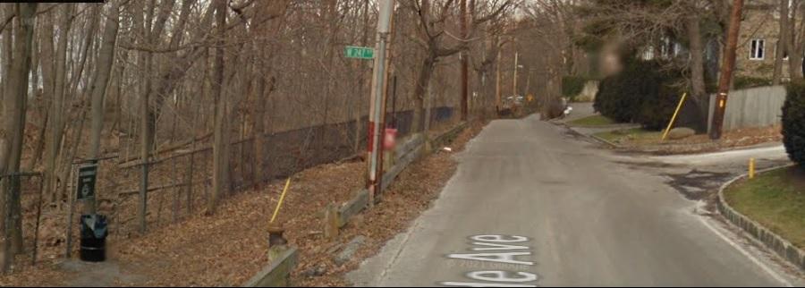
If you are walking North up Palisades Ave, you can enter Riverdale Park at W.247th Street. As you continue walking north and 1 block before you can see the turn going up the hill on Spalding Lane, you will find a Marker that is not a Mystery. Jim Vogt sent me the “Mystery Marker” image.
-
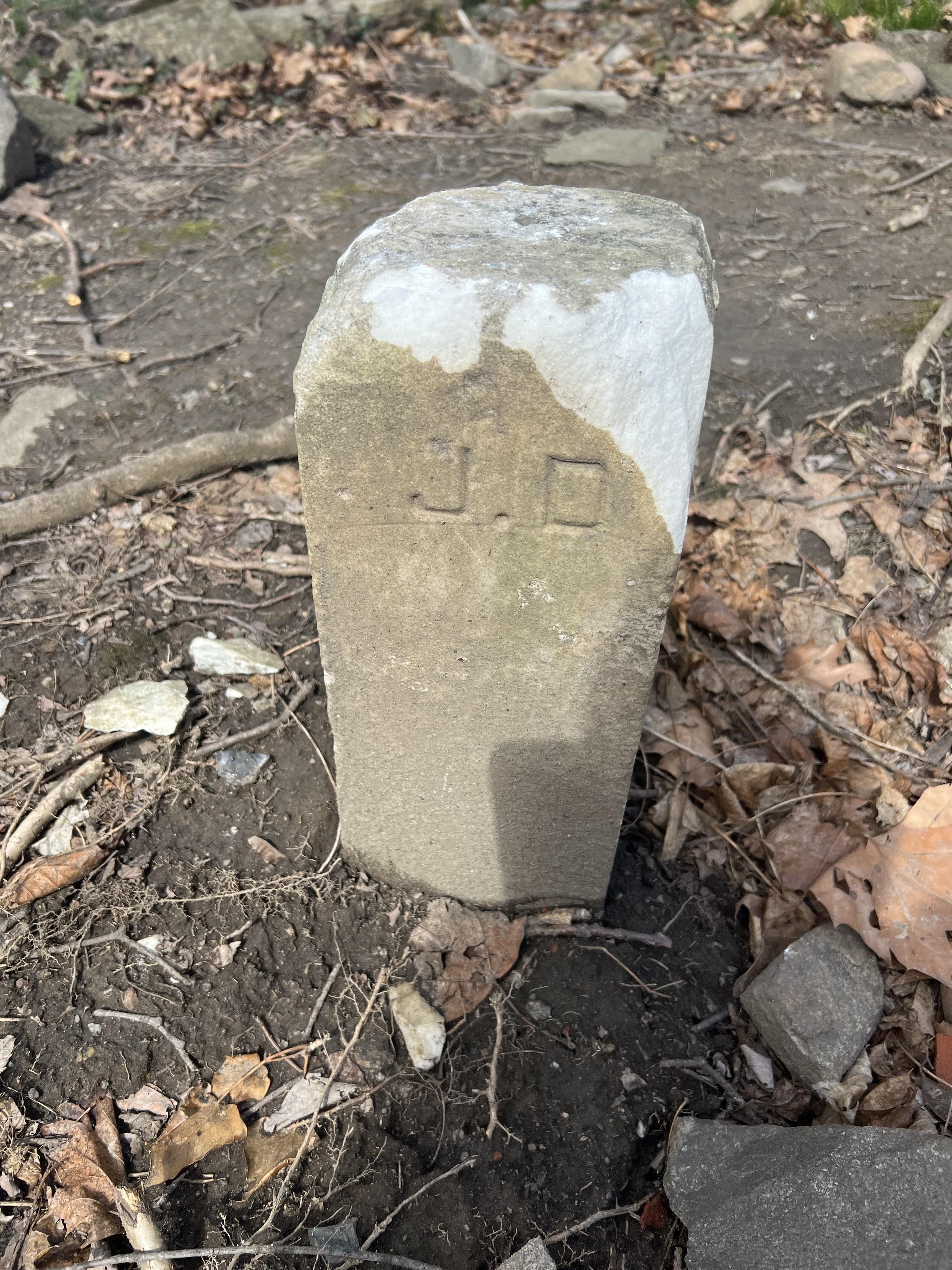
November 11, 2023 at 9:04 am #3785
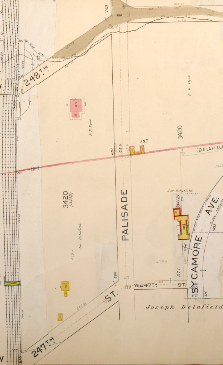
Plate No. 52, Part of Ward 24, E. Belcher Hyde Map 1901 – MARKER J. D. ( Joseph Delafield )
-
November 11, 2023 at 11:43 pm #3786
Thank you, Nick, for the superimposition of the maps. It gives a good understanding of the relationship of the earlier map with today’s reality. Monument #54 is well-separated from lot 54 and remains a puzzlement.
Could there be government records of early surveying in the area of interest that might reveal the purpose of the monument? Perhaps the survey of 740 W 232nd street might show something. Streets appearing, moving, being truncated would need surveying I would think. I wonder if survey maps drawn when the Seton Hall grounds were repurposed would show the monument. Actually this sounds like a lot of work to uncover the provenance of a wayward monument.
-
November 12, 2023 at 1:24 pm #3787
I think it has to be a property marker. It looks very similar to the one Tom posted for the Delafield property. And I can’t think of anything else it could be.
-
November 12, 2023 at 1:38 pm #3788
I agree with you, Nick. I’m unfamiliar with surveying methods; are monuments numbered when there are many of them placed in order to easily identify them on a survey map? I can see how that would be helpful. Perhaps there exists a map with such a reference. It would be nice to “nail” this down, so to speak. lol
-
November 13, 2023 at 1:55 pm #3792
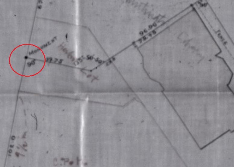
It is great when you have any of the original survey maps, that I found at the Huntington Free Library, 9 Westchester Square. We also wondered what that granite block was that we uncovered on our property. Back in 1880 when the executors of the Van Schaick Estate ( his will ordered a Library built to honor his predeceased wife ) were assembling the various lots to be purchased from the Adee Estate, the monument is labeled on the lot line corner. When I find the picture of the monument buried in the ground, just like the others,
 I will post it.
 -
November 13, 2023 at 5:19 pm #3795
Thomas, thank you for posting this picture. However, I’m confused as to what it represents. Could you explain?
-
November 14, 2023 at 1:01 pm #3796
The red circle is the location the HFL intersection of property lines and the location of a granite monument. It is in fact labeled ” Monument “
-
November 16, 2023 at 3:51 pm #3797
Thank Thomas. The is a survey of which property? The notations are too fuzzy to read. Where is this property located?
-
November 17, 2023 at 1:06 pm #3798
the original survey maps, that I found at the Huntington Free Library, 9 Westchester Square. ( read above)
-
June 20, 2026 at 7:45 pm #5307
There’s an interesting story to these and other monuments in Kingsbridge area, and if I could remember you would all be impressed. Sorry. I heard it while studying title insurance at NYU. I can tell you these monuments are survey monuments that were measured using the true north baring, with chains as the tool for determining length. There is a geostationary monument, in Battery Park maybe, which Army Corp. Surveyors used as a reference point to set down the short obelisque markers one sees on side of state roads, especially. The markers along Broadway, between the Battery and Albany are the oldest in the U.S. (that may be much of the story I can’t recall). How old you ask? Pretty damned old. The markers pictured herein would have been used as starting points when lands were further subdivided. Subsequent surveyors placed rods, and later brass pins, at beginning corners, which later surveyors use as starting points. Incidentally, There are two other main geostationary monuments in the U.S. – in Colorado and S.F.
-
June 20, 2026 at 8:00 pm #5308
Meant to write that the pictured markers would have been set at the corner of property as measured from the nearest official monument (obelisque). How the corner was determined would have been determined by reading deed descriptions and maps. NYS real property law follows English Common Law, which made made things simpler.
-
-
-
AuthorPosts
- You must be logged in to reply to this topic.