Home › Forums › The American Revolution › Patriot Army’s Retreat through The Bronx, October 1776
- This topic has 4 replies, 3 voices, and was last updated 4 years, 7 months ago by
Thomas Casey.
-
AuthorPosts
-
-
November 19, 2021 at 4:52 pm #2335
Last night I heard an interesting lecture at the East Bronx History Forum presented by Eastchester Town Historian, Richard Forliano, and historical interpreter, Mike Grillo. The topic was The Bronx/Westchester during the American Revolution. At the end, an audience member asked a great question:
When the patriot army retreated from Manhattan to White Plains in October, 1776, what roads were taken as they passed through today’s Bronx?
Nobody (including me) had a definitive answer. In Westchester County During the American Revolution, the author Otto Hufeland, is murky on this issue: “Washington’s army began its laborious retreat through the hills west of the Bronx [River]” on the way to White Plains. This is unusual vaguery from Hufeland, whose book otherwise provides plenty of specific detail, leading me to believe that the answer may not be so obvious.
General Heath issued the following orders from Kingsbridge on October 21, 1776:
The division is to march . . . at eight o’clock this morning. Colonel Thomas and Colonel Drake will send to each regiment a guide who is well acquainted with the road to White-Plains, and the vicinity of that place . . . Colonel Thomas . . . will march his brigade by the Albany road to Dobb’s Ferry, receive his baggage, etc, from the boats and then join the division [at White Plains] without delay.
Heath refers to two roads: “the road to White-Plains” and the “Albany road to Dobb’s Ferry.” The “Albany road” is obviously the Albany Post Road, which largely follows the course of today’s Broadway. It is less clear what Heath meant by “The road to White-Plains.” None of the roads or trails leading north out of Kingsbridge were generally referred to in this way even though you could theoretically take any of them to get to White Plains.
[caption id="" align="aligncenter" width="565"]
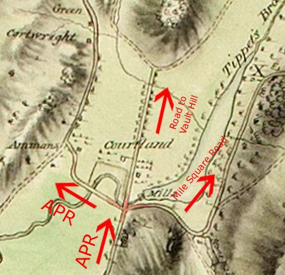 Clipping from 1781 British Map, Area Adjacent to Kingsbridge, showing the Albany Post Road, the Road to Vault Hill, and the Mile Square Road meeting just south of the Van Cortlandt House. Clements Library, University of Michigan.[/caption]
But a few days earlier, Washington ordered General Sterling with 2,000 troops to head to White Plains from Washington Heights. The diary of Chaplain Andrew Hunter gives a good idea of the route that this division took to get to White Plains and it might just explain what Heath meant by “the road to White-Plains”:
18 Friday. In the morning we were connected to Ld. Stirling’s Brigade–about 12 O’Clock we were ordered to march to Mile Square, in Phillip’s Mannor…
19 Saturday. March’d to Tookahoe [Tuckahoe] where we encamped…
20 Sunday. We had orders to march, before the Sun rose, for White Plains.
If he went from Kingsbridge to Mile Square, he would surely have taken the Mile Square Road, which led from today’s Van Cortlandt Park to about where the Cross County Shopping Center is today. The road still exists, in part, as Van Cortlandt Park East in The Bronx and as Kimball Ave in Yonkers. Next, he camped at Tuckahoe, which is further north on the Mile Square Road. That leg of the road still exists in Yonkers and is still called Mile Square Road. It intersects with Tuckahoe Road south of St. Mary’s Cemetery.
So it would seem that some troops took the Mile Square Road to get to White Plains while others took an indirect route via the Albany Post Road.
-
November 20, 2021 at 11:58 am #2336
Nick, As I mentioned the other night – the OLD Boston Post road up the hill ( Heath Ave) from The Kingsbridge was steep and after passing Ft Independence heads a little Southeast & downhill to the Bronx river. Going along Bailey Ave from Heath to “Mosholu” and /or Up Broadway to the Van Cortlandt Mansion and meeting up with “Mosholu Cut Through” aka Miles Square Road that meets the Fordham Ridge at Jerome Ave and 233rd St. Basically…. At VC Mansion, taking the Major Deegan to 233rd and Van Cortlandt Ave East ( AKA Miles Square Road) North onto Kimball Ave east of the Yonkers reservoir. This way GW stays on the high ground above the Bronx River vs Webster Ave and Bronx River Road ( Yonkers ) along the Bronx River.
-
November 20, 2021 at 2:08 pm #2337
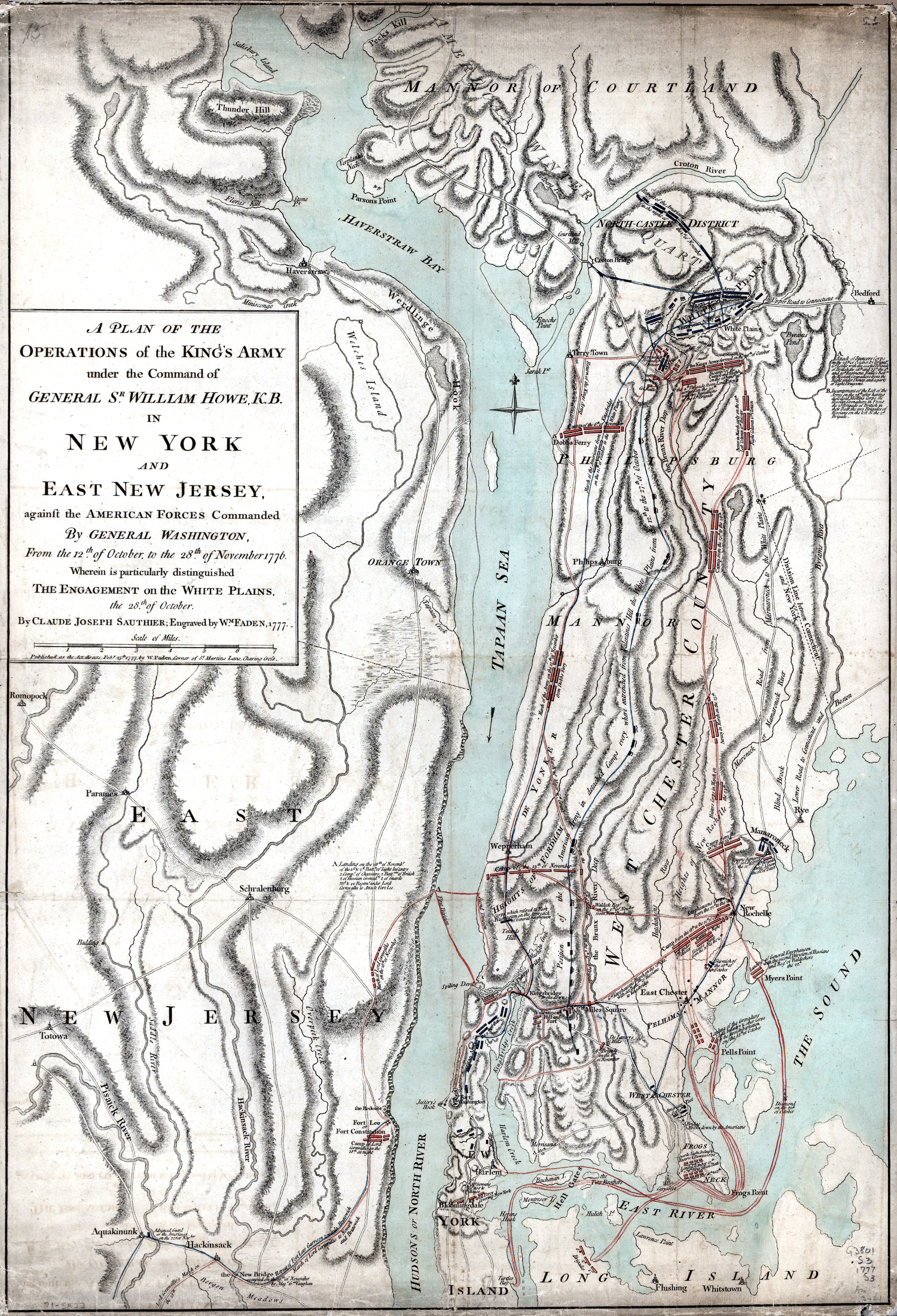
That’s a good point about wanting to stay on the high ground because the Patriots were very concerned about skirmishes breaking out on their retreat to White Plains. Even though it contains many errors, the below map drawn by a British mapmaker, shows Patriots stretched out along western bank of the Bronx River all the way from Fordham to White Plains. It also shows Patriot forces moving north on the Albany Post Road (click on map for larger image):
-
November 21, 2021 at 12:22 pm #2338
https://digitalcollections.nypl.org/items/4100c4f0-ed31-0133-8c44-00505686a51c
I was looking at this map with Albany Post Road and noticed/processed for the first time how much of the area was confiscated and redistributed by the Committee of Forfeiture!
-
November 21, 2021 at 2:43 pm #2339
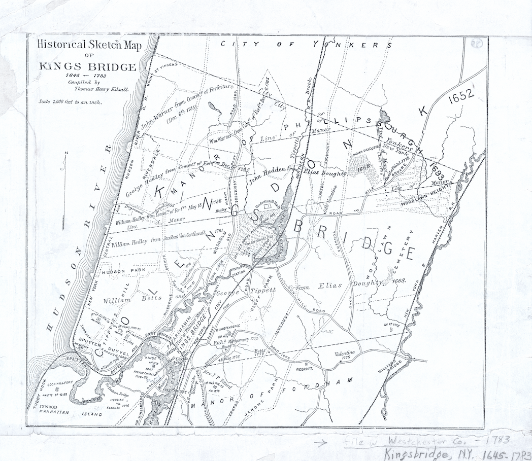
It is good to compare the 1777 map and the 1887 maps together.
The 1777 map has the Bronx River to far west, along with the Hutchinson Rive
The Old Boston Post Road, along with the Miles Square Road, is too far South.
-
-
AuthorPosts

- You must be logged in to reply to this topic.