Home › Forums › The Colonial Era › Reason to Doubt the Story Behind Gun Hill Road?
- This topic has 3 replies, 3 voices, and was last updated 1 month, 1 week ago by
Brendan.
-
AuthorPosts
-
-
February 4, 2020 at 8:29 pm #1261
Gun Hill Road–certainly a name that is hard to forget. But I just recently came across something that made me wonder about the origins of the name “Gun Hill” and I am wondering what others think about it. If you are thinking that Gun Hill Road is beyond the boundaries of what might be considered Kingsbridge, think again. Before the major highways came through the area, Gun Hill Road reached as far west as Van Cortlandt Lake.
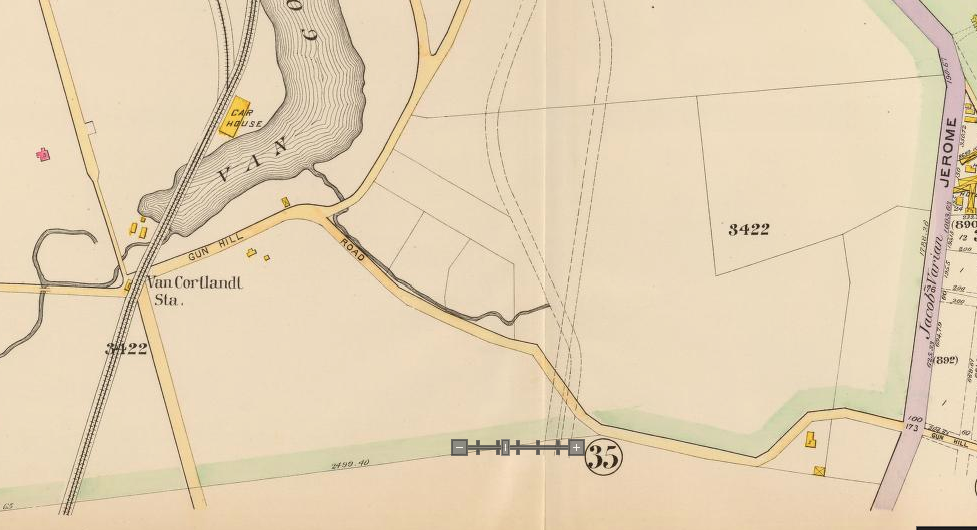
It is certainly an old road–going back to the colonial era as a path and possibly earlier. This 1781 British intelligence map shows the path that would be called Gun Hill Road stretching from Van Cortlandt Lake to where it met up with the Boston Post Road. It looks like it was a shortcut to get from the Albany Post Road to the Boston Post Road (useful for anyone going from Yonkers to the east Bronx or vice versa).

map from the Clements Library at the University of Michigan
Robert Bolton described this road in his 1848 history of Westchester. Since it was not yet called Gun Hill Road, he referred to it as the “ancient road . . . from Yonkers to William’s Bridge and Westchester.” As far as I can tell, Bolton did not use the words “Gun Hill” at any point in his history.
According to John McNamara’s History in Asphalt, “On January 25th, 1777 a small party of Americans dragged a cannon to the top of the hill west of the Bronx River and fired on a British force. This hill is now inside Woodlawn Cemetery (Summit sector) and was called Gun Hill long afterwards.” The Patriot commander that was in command of that “small party” was General William Heath. He wrote about the skirmish in his diary (here).
Today, there is a monument to this skirmish located in Woodlawn Cemetery atop Gun Hill:
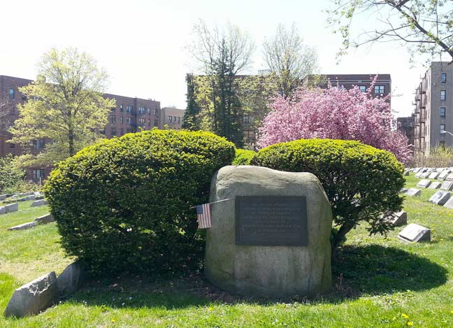
photo: I’m just walking
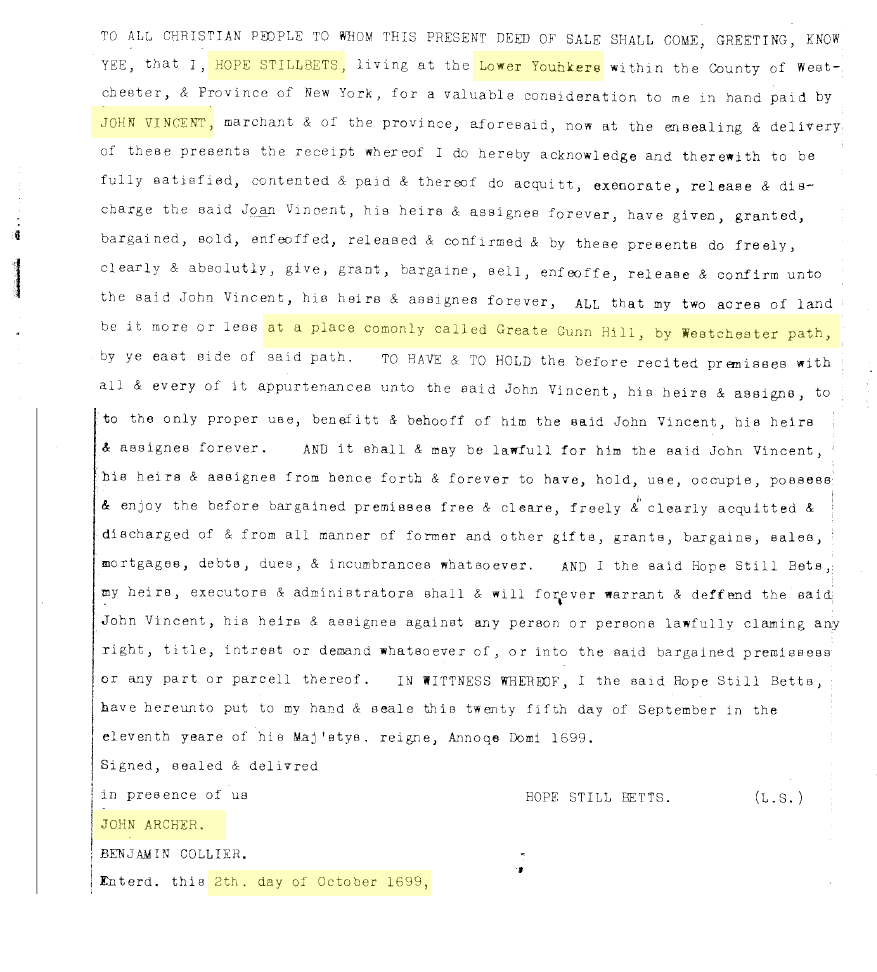
To make a long story short, the Patriot soldiers brought their big gun to the top of the hill to drive off the enemy and from that point on, the place was known as Gun Hill. Makes sense. What does not make sense is that there would be a reference to a “Gun Hill” in this area 78 years before this Revolutionary skirmish–but that is exactly what I found. The reference comes from a 1699 land deed (scroll down to read it). It details the sale of 2 acres of land in “Lower Yonkers,” as this area was known, “at a place commonly called Great Gun Hill.” The seller is Hopestill Betts, who was the son of William and Alice Betts–two of the first English colonists to live in the area that is now Van Cortlandt Park. The buyer is John Vincent, who is described as a “merchant.” In the 17th and 18th centuries there were a number of Vincents in Lower Yonkers that owned land in today’s Van Cortlandt Park and beyond.
So my questions are:
1) If Gun Hill predates the Revolution, why was it called Gun Hill? And
2) Is the original Gun Hill described in the 1699 deed the same hill in Woodlawn cemetery that we call Gun Hill today?As far as the first question goes, I really have no idea why it could have been called Gun Hill in 1699. As regards the second question, I think the 1699 deed could be referring to the same hill in Woodlawn cemetery that we call Gun Hill today. The two acres that were sold in the deed are described as “by Westchester path, by ye east side of said path.” It is reasonable to suppose that “Westchester path” is actually the road that would later become Gun Hill Road where it led from Van Cortlandt Lake to the Boston Post Road. Remember that Robert Bolton in 1848 described that same section as the “ancient road . . . from Yonkers . . . to . . . Westchester.” In the British map you can see that hill that we today call Gun Hill is indeed east of this path.
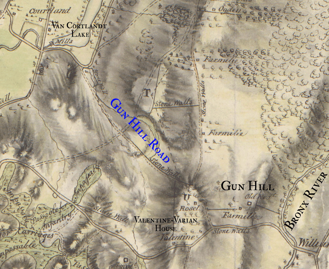
Another curious feature of this map is the indication of a dwelling at the foot of Gun Hill labeled “Farmilie.” This is a misspelling of the name Vermilye, which was another old Westchester family that was spread out all over this area. I found some genealogical leads connecting the Vermilye family to the Vincents (who bought the land on the “Great Gun Hill” in 1699) but nothing that exactly fits the time frame.
As far as I am concerned, the origin of “Gun Hill” is something of a mystery.
The 1699 deed is below:
-
February 5, 2020 at 12:08 am #1262
Great find Nick, and a good connection upon reading the old document.
If correct your killing oral and traditional history naming conventions !!While the English just took control of Niew Amsterdam /New York at the time of this document, the whole area was still Dutch, language and customs. A dutch translation of “greate Gunn Hill” as written in the document would be ‘grote kanonheuvel’. So it looks like a direct translation from the Dutch to English.
As to why the name Gun Hill” ? if I had to guess It’s due to the rough geographical shape of the hill . I can imagine back then the view of the hill from a side could look like a cannon. It’s not common for hills and mountains to be named by what they appear to look like. There are many mountains named ‘sugar loaf’. In our area up the Hudson opposite Bear ountain is Anthony’s nose. Traditioun has it named for Anthony DeHooges who along with Adrian Vander Donck were officers of the Dutch patoonship Rensselaerwyck of Kiliaen Van Rensselaer. Looking at the map you can see the long ridge in the form of a cannon. Again good research in making the connection for a new meaning of a familiar local name.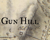

-
February 6, 2020 at 3:52 pm #1263
I think your idea is entirely possible–that the hill is named for its shape rather than for the presence of cannons. I would want to look at more maps to get a better look at the topography there.
The William’s Bridge crossing of the Bronx River, which is adjacent to Gun Hill, was written about before the Revolution. It was the boundary between Yonkers and the Manor of Fordham and it was named “Cowangongh” according to the 1669 deed between the Munsee and John Archer, who was the lord of the Manor of Fordham. That deed is interesting because it contains many of the Munsee place names for locations in our part of The Bronx. You can check that out here. I recently got a chance to look at a photograph of the original deed and it is amazing to see because the Native Americans signed it using symbols or pictographs instead of spelling out their names.
I think the Gun Hill would have been important because it overlooked this crossing of The Bronx River. It would be pretty funny if its name comes from its shape as opposed to the fighting that occurred there.
-
-
June 23, 2026 at 3:18 pm #5321
Seems unlikely cannon would be sent to that neighborhood in the 17th Century, which has me wondering if we’re not continuing a misinterpretation of ‘gun’. Perhaps this deed, subsequent maps, refer to an anglicized noun, verb, adjective, or surname? I worked in the title insurance business for many years, and more than a few knowledgeable real estate attorneys were unsatisfied with the consensus story. In ’76 our OLA 6th grade class took a field trip to an historic house in the Bronx or Westchester. We stopped coming down stairs from second floor, to let another class pass. On my right was a painting of mounted George Washington et al imploring colonial troops to move guns being pulled by horse or oxen up a muddy hill. The lengthy caption described the scene. The guns were definitely stuck in the mud – that was the drama. Rain or snow. Forgive my not having a better memory of what it read, but I’m certain I recognized the perspective as looking W/NW up what is now called Gun Hill Road. Washington was not at the skirmish for which the road is said to be named, no? Nester Danylek was pres of BHS in ’89, when I ran this by him. He didn’t know. Wasn’t really curious as was. Didn’t find the painting by searching online inventory of historic Bronx houses. The stairs were on the left side of the house. Maybe someone reading this will come across it. I’ll shut up now.
-
-
AuthorPosts
- You must be logged in to reply to this topic.