Home › Forums › The Colonial Era › Was the Albany Post Road earlier known as a “Mill Path?”
Tagged: 1674 deed
- This topic has 14 replies, 5 voices, and was last updated 5 years, 4 months ago by
Zach Youngerman.
-
AuthorPosts
-
-
March 15, 2021 at 2:45 am #1894
I came across something odd in a VERY old land deed (from 1674) dealing with land in our area–a mysterious reference to a “Mill Path.” I am starting to think that this path could have been a humble predecessor to the Albany Post Road, one of the country’s oldest roads.
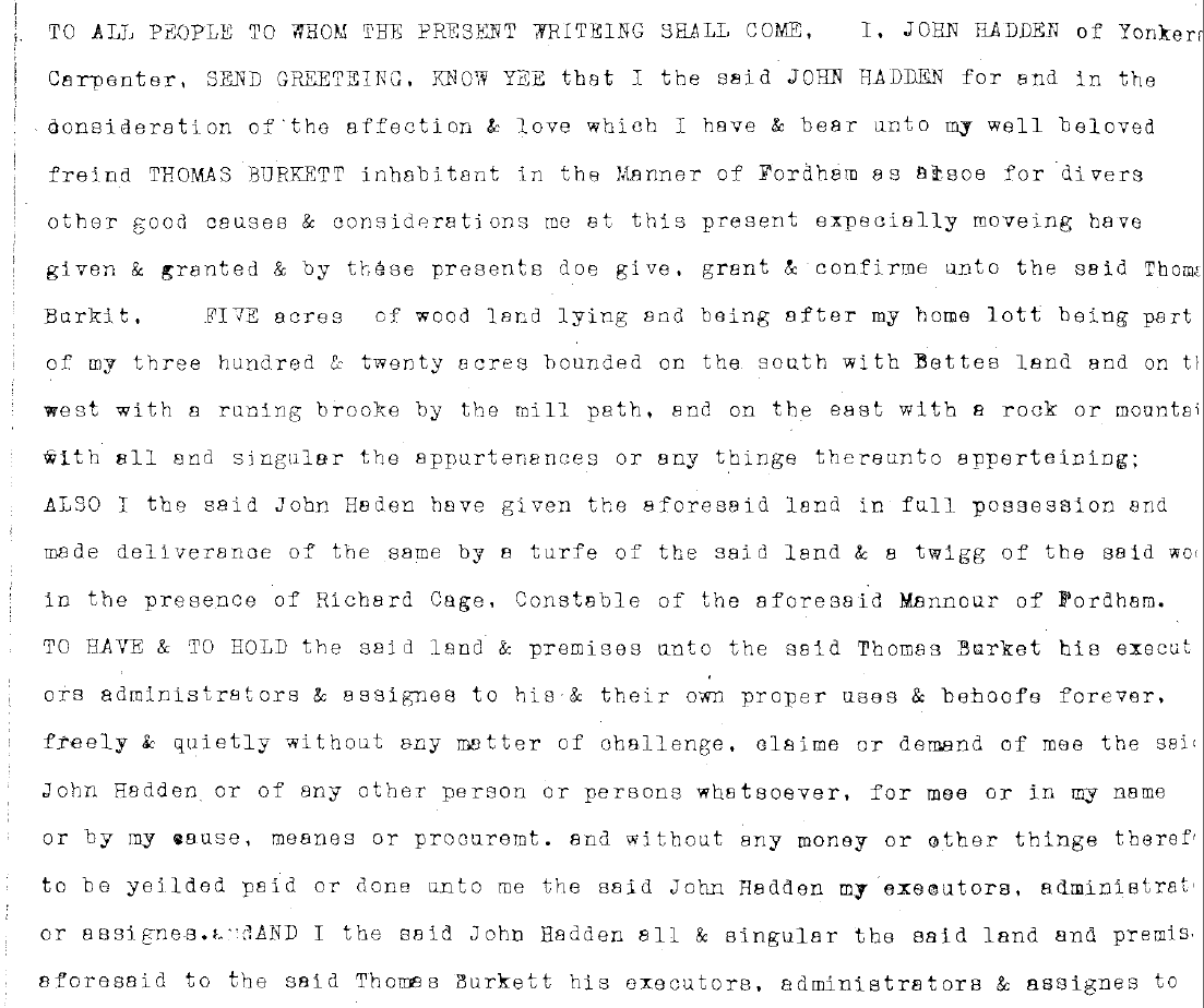
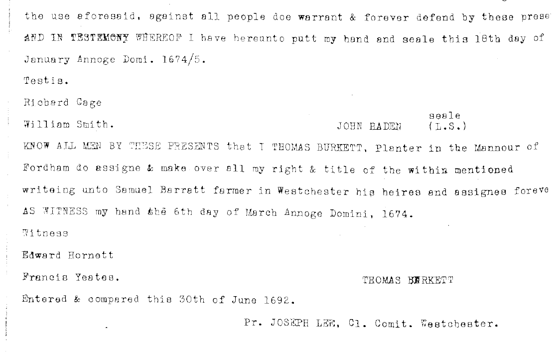
In the deed I found, John Hadden confers 5 acres of woodland to his “well beloved friend Thomas Burkett, inhabitant in the Manor of Fordham.”
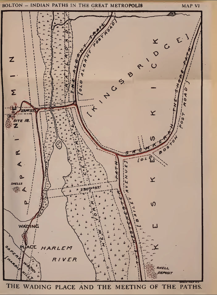
John Hadden was an early colonist in our area and he purchased 320 acres of land in 1668 constituting a large portion of today’s Van Cortlandt Park. A local historian mapped this purchase:
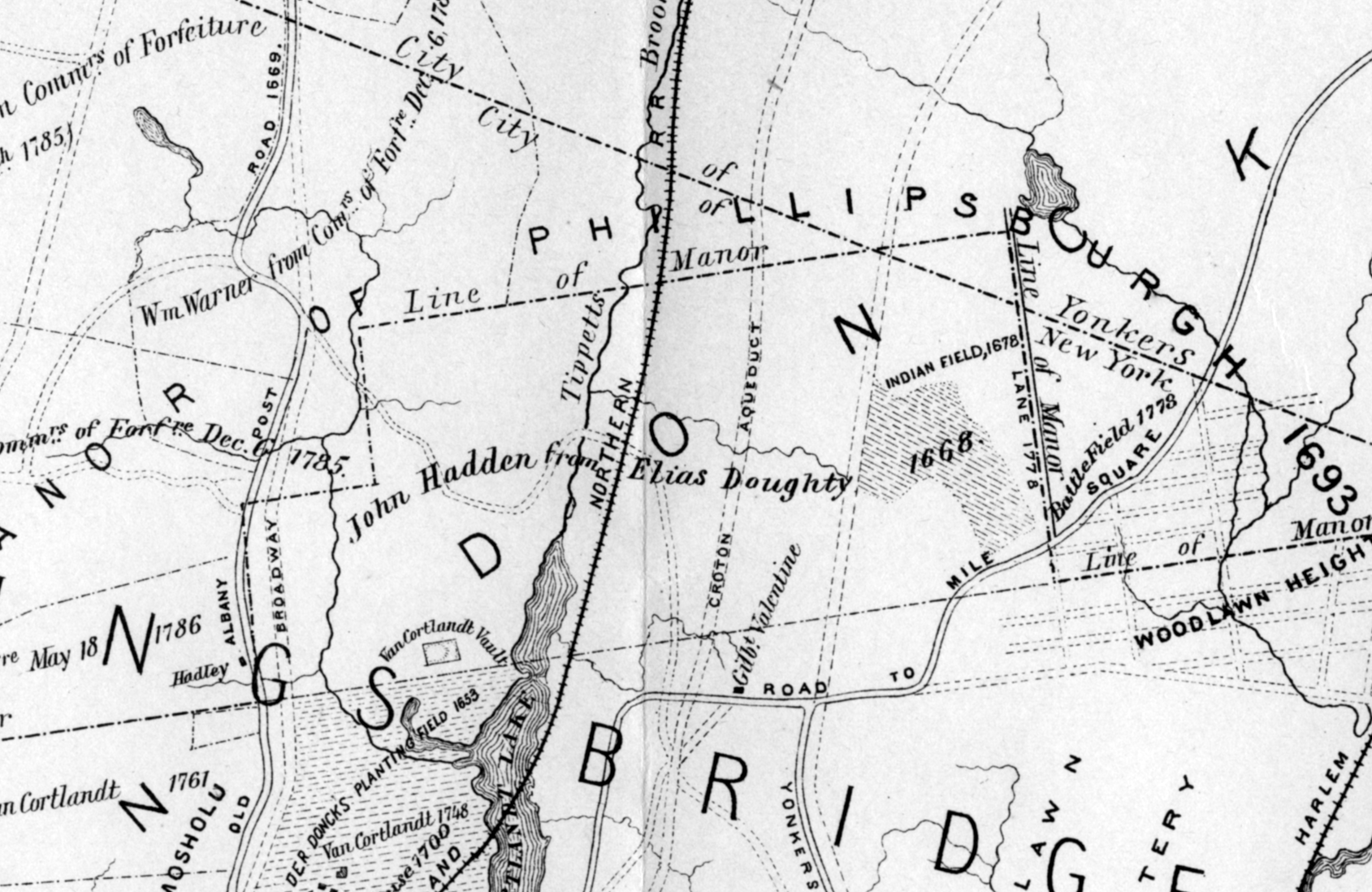 The map is a little disorienting with all of the text but you can see Broadway on the left-hand side and Woodlawn on the right. John Hadden’s land was the 6-sided polygon in the middle labeled “John Hadden from Elias Doughty 1668.”
The deed describes the 5 acres as “FIVE acres of wood land lying and being . . . part of my three hundred and twenty acres bounded on the south with Bettes land and on the west with a running brooke by the mill path, and on the east with a rock or mountain.”
So in this deed Hadden is transferring ownership of 5 acres of the 320 acres to his friend. To me, it sounds like this five acres is to the west of the Vault Hill in Van Cortlandt Park, which could be the “rock or mountain” that he described in the deed. The “running brooke” mentioned in the deed could be the stream that once came down from the hills of Riverdale and crossed the Parade Ground in Van Cortlandt Park–later known as Turtle Brook. You can see it on the map just to the left of the Van Cortlandt Vault. So I am wondering, when he referred to the “mill path,” could that have been the Old Albany Post Road before it expanded into an actual road–when it was just essentially a path?
The deed was made in 1674 well before there were any Van Cortlandts in our area, so it could not have been referring to a path to the Van Cortlandt Mill, which came later. The deed was also written before there was anything called the Albany Post Road. That wasn’t constructed and designated as a “post” road until the 1700s. But the Albany Post Road was very likely a well-used path by colonists before it was considered a “road.” It may have even had an earlier history as a path used by local Lenape people.
The first colonist to settle in today’s West Bronx, Adriaen van der Donck, first bought land here in 1646. He then had a mill built in today’s downtown Yonkers, where the Saw Mill River empties into the Hudson (hence the name “Saw Mill River”). And yet, Van der Donck’s house was located in today’s Van Cortlandt Park, not far from the house museum. He must have needed a way to get from his house in today’s park to his mill in Yonkers. Perhaps this was the “mill path” in the deed. That would be the same general route as what would become the Albany Post Road leading me to theorize that the “mill path” was the humble predecessor to one of America’s oldest roads.
[caption id="" align="aligncenter" width="526"]
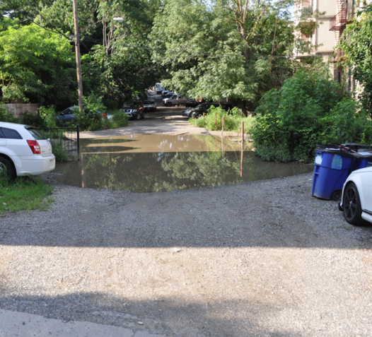 An old section of the Albany Post Road north of W. 251st Street west of Broadway[/caption]
I am posting the full 1674 deed below should anyone care to check it out.
-
March 15, 2021 at 2:58 am #1895
Fascinating, Nick. I see that the Albany Post Road is parallel to Broadway in this map. Did it generally go along the route of Broadway up through Yonkers and Westchester?
-
March 15, 2021 at 12:15 pm #1896
So was this a mis-reconstruction of the path or did the path and post road veer back west to go along the future Broadway?
-
March 15, 2021 at 12:20 pm #1897
Incidentally, I recently happened upon a Post Road marker in Port Chester https://www.instagram.com/p/CMIRasTFZ1C/?utm_source=ig_web_copy_link
-
March 15, 2021 at 12:32 pm #1898
Thanks. Keep in mind this is just a theory. It is hard to be completely sure because given how sketchy the information is.
Yes, generally the Albany Post Road roughly follows the route of Broadway or Route 9 through Yonkers and Westchester. The original post road was very circuitous to avoid streams and marshes–sort of like the path of least resistance. But by the time Broadway was cut through in the 19th century, they had more manpower and better methods for making roads and they made them wider. But the newer roads didn’t diverge greatly from the same general course as the old roads.
To give you an idea of how rough the old roads were, here is a snippet from a 1785 map showing the Albany Post Road through Riverdale. Note that there is a sharp bend in the road near today’s Mosholu Ave labeled “Breakneck Hill.” No doubt it had that name for a reason! The generals that relied on these roads during the American Revolution were constantly complaining about them and blaming them for why they got lost or were late to the battle.
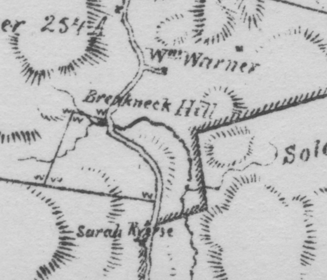
As a side note, north of 251st Street, you will find a road called “Post Road.” Just to the east is an unpaved lane, which was the original Albany Post Road. Just to the east of that is Broadway. All three are running parallel roughly north to south.
-
March 15, 2021 at 12:36 pm #1899
Fascinating. Thank you
-
March 15, 2021 at 2:44 pm #1900
The 1674 deed appears to be typed. Is that unusual for that time?
-
March 15, 2021 at 4:00 pm #1901
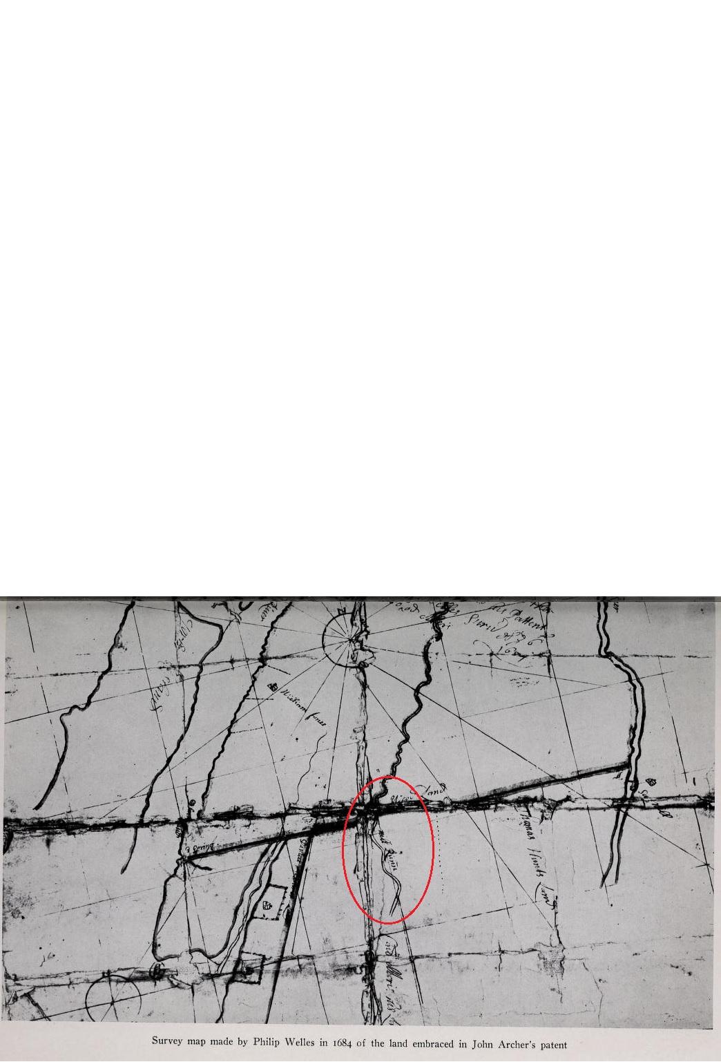
No Type writers in 1680 …The deeds were transcribed. The Map of The Manor of Fordham, John Archer Patent of 1684 details near the bottom of the map, the ” Mill Run”, it runs along side the Bronx River as they approach Van Cortlandt Park in the North. I believe the Mill Run, Mill Brook went as far north and into Mosholu Parkway.
-
March 15, 2021 at 4:01 pm #1902
-
March 15, 2021 at 4:02 pm #1903
-
March 15, 2021 at 9:45 pm #1905
Last time I was up in the Westchester County Archives, where the deeds are kept, I was told that the deeds were typed up as part of a WPA project.
Thanks, Zach and Tom for sharing the maps. Great stuff. I’ve never seen the Bolton map. What book is it from? On that map you can see how Broadway is a straight line but the Albany Post Road had to zig-zag a bit to stay out of the muck. Just above of what is depicted on that map, the Albany Post Road went north under today’s Bailey Avenue and into today’s Van Cortlandt Park. It crossed the park and went north along the ridge just to the west of Broadway.
The “Mill Runn” on the 1684 map is also interesting. This is out of my geographic area of expertise but just under where it says “Mill Runn” it looks like “Coll Morris his land.” I wonder when Morris built his mill. This map shows the source of that stream near the Bronx River somewhere around where the Botanical Garden is. It labels that stream as “Morrisina Creek.” It looks like the Harlem Line of Metro North was built partially on that creek bed.
-
March 15, 2021 at 10:36 pm #1906
Nick that last map is amazing. Such high quality.
The image is from “Indian Paths in the Great Metropolis”
Page 90 and onwards
https://archive.org/details/indianpathsingre01bolt/page/90/mode/2up -
March 15, 2021 at 10:39 pm #1907
What’s amazing is that it looks like a lot of the impassable area became the Jerome Reservoir, if I’m reading things right
-
March 17, 2021 at 1:19 pm #1909
Yes, Zach, that’s what I think as well. I was surprised how swampy that land was given its higher elevation. Since this map was an intelligence map, they needed to know what were areas were off-limits for troop movements, cavalry, etc. Eric Sanderson used this map for his historical ecology project and that’s how I first learned about it–from his notes. When I first saw it, I was giddy because of all of the local history info.
I did a very rough geo-referencing of this map over a contemporary one that you can check out here:
https://kingsbridgehistoricalsociety.org/khsmaps/1781Clinton3/index.html#1781Clinton3/ol3
It’s not my finest work but it gives you an idea of where things were. Use the slider on the top right to adjust the opacity of map layer. You’ll be able to see the contemporary path of the Albany Post Road and the “Mill Runn” pretty clearly using it.
-
March 17, 2021 at 1:33 pm #1910
Oh that’s a great tool…very satisfying. Amazing to see how much of Bailey Road, Old Post Road and Broadway retain the former paths, whereas Van Cortlandt Park erased the history of trails.
-
-
AuthorPosts

- You must be logged in to reply to this topic.