Georeferencing Spuyten Duyvil's Hilltop Forts

Earlier, I published an article about the imminent development of a vacant lot, where Fort No. 2 once stood.  If the hilltop forts of Spuyten Duyvil are not already familiar to you, I would recommend you read that first.  However, for those skeptical of Fort No. 2’s historical footprint (or for those that just want to learn more) I thought it would be worth demonstrating how maps can be georeferenced to definitely locate the former Fort No. 2 on that vacant lot.  Georeferencing is the process of aligning, scaling, and orienting maps or diagrams to one another.

Today the location of the vacant lot where Fort No. 2 once stood can be described using streets, block and lot numbers, or GPS coordinates as reference points.  But during the Revolution, and for many years after, none of these descriptors existed.  But what did exist were the remnants of the forts themselves.  And local historians of the 19th century could see them and describe their location in relation to local landmarks.  By using the notes of these early historians alongside modern maps, and a British engineering diagram, those landmarks can be used to pinpoint the modern day locations of Spuyten Duyvil’s hilltop forts–including Fort No. 2.

"A Plan of the Works on Spikendevil Hill"

The British engineering diagram comes courtesy of the Library of Congress.  The key to understanding maps from the Revolution is to know why they were made.  This one was clearly drawn for the purpose of showing the features, dimensions, and relative position of the 3 Spuyten Duyvil hilltop forts.  It is entitled “A Plan of the Works on Spikendevil Hill with the Ground in front Protracted from a Scale of 200 Feet to an Inch.”  While many other maps exist that depict the hilltop forts, this one offers the most precision as it is “zoomed in” on the forts themselves.

The numerals "1," "2," and "3" can be seen in each of the squares representing the forts. Note "Tippets House" on the right edge..

Fort No. 1

Fort No. 1 was the westernmost of the hilltop forts (by the top-left of the above map) and it will be our first reference point.  19th century historians had an advantage in studying Revolutionary fortifications in that their remains were still visible on the surface.  In the 1880s, local historian Thomas Henry Edsall noted that Fort No. 1 “was located where the house of the late Peter O. Strang stands in grading for which all traces of the old fort were obliterated.”1  An 1872 Beers Map shows the location of the Strang mansion on Spuyten Duyvil Hill.

Comparing the 1872 Beers map to a contemporary Google map, it is clear that Washington Street follows the path of today’s Kappock Street while Independence Ave of 1872 roughly follows Independence Ave of today.  Henry Hudson Park would have been to the south of the Strang mansion. 

The Strang mansion was quite large and eventually passed into the hands of William Muschenheim,2 an owner of the Hotel Astor.  He dubbed the mansion Nipnichsen Terrace.  A 1911 Bromley map depicts the building with the contemporary street names.
The Henry Hudson Monument was built to the southeast of the Strang (later Muschenheim) mansion as shown in the 1911 Bromley Map (above). The mansion can be seen behind the trees on this Hotel Astor menu cover (right). The view is looking west with the Henry Hudson Monument on the left.
In 1912 Stephen Jenkins noted that “when the [Strang] house was built, both Indian and Revolutionary relics were unearthed, some of which are still preserved in the house.”3  The mansion stood there until 1994, when it was torn down by the administration of the Francis Shervier Home and Hospital.
This undated aerial photo depicts the contemporary streets of Spuyten Duyvil. The Schervier Hospital is the large complex at the top-left. The Strang or Muschenheim mansion can be seen to the right of the bottom of the hospital. The shadow of the Henry Hudson monument can be seen just below the mansion and to the right. This was the location of Revolutionary Fort No. 1 according to local historians that saw it first-hand..

So the location of Fort No. 1 is clear but in order to properly orient the 1778 British engineer’s map to a contemporary one, at least two reference points are needed.  Even more can be helpful to confirm the orientation.  Our second reference point will be the easternmost fort–Fort No. 3.

Fort No. 3

As was the case with Fort No. 1, a 19th century mansion was built upon the ruins of Fort. No. 3.4  In 1887, Thomas Henry Edsall wrote that “Number Three stood where Warren B. Sage’s house now stands, on the easterly brow of Spuyten Duyvil Hill.”5  The Sage mansion would become the Edgehill Inn.  Both the mansion and the inn appear on the aforementioned 1872 and 1911 maps.
The Sage mansion is dead-center. Without doubt the location of the mansion was chosen for its view over the valley of Kingsbridge--the same reason why the fort was built there.
The 1911 map shows the contemporary street names and the Edgehill Inn dead-center. It is the large building on Arlington Avenue between W. 227th Street and W. 230th Street.

Since several of the homes around the inn are still standing, it becomes possible to precisely find the location of the inn and thereby know the location of Fort No. 1:

Georeferencing the British Map

With the locations of Forts No. 1 and 3 known, it now becomes possible to georeference the 1778 British map to a contemporary one.  The process is depicted in the below animation.  You will need to pause over the image and let it cycle through to get the full effect.

What is remarkable about the process is that after properly orienting the engineer’s map and bringing it to scale, the results match the historical record exactly.  Both Forts No. 1 & 3 are where they should be.  Perhaps this is not a surprise given the precision and detail apparent in the British map.  But is there anything else on the map that could verify our results?  Yes, and it comes thanks to a seemingly insignificant detail. 

"Tippet's House"

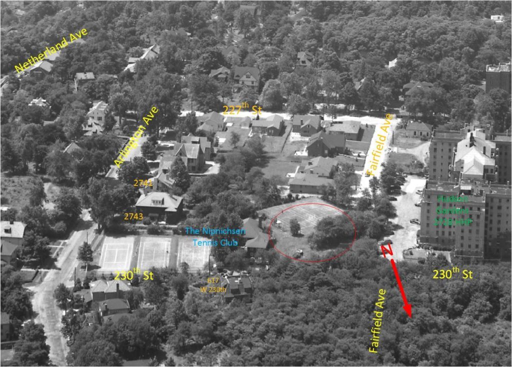
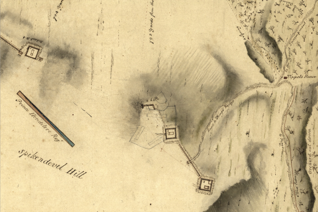
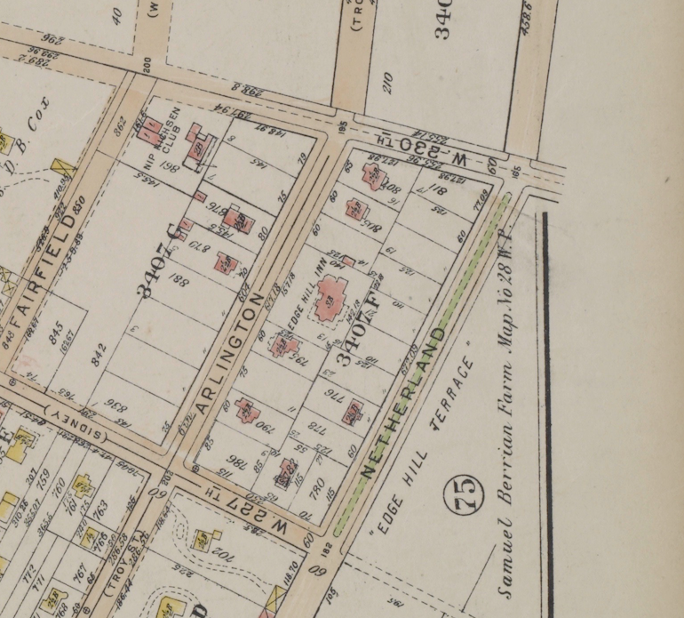
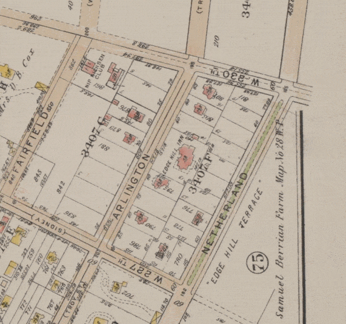
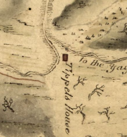
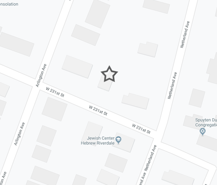
For some reason, the British map maker saw fit to depict the Tippett residence in this diagram.  According to the results of our georeferencing, this house should have been located on the north side of West 231st Street between Arlington and Netherland Avenues, where today there is a home.

If there was some way to verify that the Tippett home was actually located at this place, it would confirm the accuracy of our georeferencing of the British map.  Thankfully there is.  Just before this plot of land was auctioned off as part of the Ewen estate in 1921, a local historian, Reginald Pelham Bolton, dug for artifacts at the Tippett homesite finding the remnants of the house in addition to numerous colonial, revolutionary, and Native American artifacts.6

That archaeological dig and the results of the auction are detailed in this clipping from the New York Daily Herald to the right.  Remarkably, one of the Tippett descendants phoned in to buy the lots containing the historic homesite, which were revealed to be lots 91 and 92 of the auction.  The Ewen estate sale auction map reveals that these lots were indeed on the north side of W. 231st Street between Arlington and Netherland Avenues–confirming the historical location of the Tippett house was exactly where the georeferenced map showed it to be.  So the position, orientation, and scale of the georeferenced maps are spot on!

Fort No. 2

Knowing that the map and satellite image are accurately georeferenced, we can now trust them to show the true location of Fort No. 2, which is confirmed to be the vacant lot that is to be imminently developed at Fairfield Avenue and W. 230th Street.

The results of our georeferenced maps show the footprint of the fort on the left.  On the right, is a 20th century aerial photo that depicts the same area.  It is hard not to notice that the orientation of the fort mirrors the orientation of the old Nipnichsen Club tennis courts that were built upon its foundation.  That rectangular piece of land is the highest point of ground in this part of Spuyten Duyvil.  It is perfectly logical that a military engineer would want to construct the fort on this piece of high ground just as it is logical that a level and squared off area would be a good place to put a tennis court.

This wonderfully labeled aerial photo (facing south) demonstrates the tennis courts of the Nipnichsen Club atop the high ground. The fact that no building foundations were ever put there give the site its archaeological potential. Photo courtesy of KHS member A. Lasky.

The precise British diagram, the historical record, satellite imagery, and modern technology confirm what local historians have known for years–the historical footprint of Revolutionary Fort No. 2 is located in the vacant lot where Fairfield Avenue meets W. 230th Street.  The outline is still visible . . . but likely not for long.

Notes and References:

1 – Edsall, Thomas H. History of the Town of Kings Bridge. Privately Printed, 1887. p. 29.

2 – Jenkins, Stephen. The Story of The Bronx. G. P. Putnam’s and Sons, 1912. p. 126.

3 – ibid.

4 – ibid, p. 329.

5 – Edsall, Thomas H. History of the Town of Kings BridgePrivately Printed, 1887. p. 30.

6 – Bolton, Reginald Pelham. A Pioneer Settler’s Home on Spuyten Duyvil Hill. The New-York Historical Society Quarterly Bulletin, Vol. V., No. 1, April, 1921. p. 13-18.