Colendonck and the Youncker's Plantation

Two 17th-Century Colonial Settlements in today's Van Cortlandt Park

Nick Dembowski – 6/27/2023

header
Left: Colonial-era maps show how a section of modern Van Cortlandt Park in The Bronx was the center of multiple colonial  settlements in the 17th century.1

The Mystery of the Building Foundations in Van Cortlandt Park in The Bronx

While digging a trench just south of the Van Cortlandt House Museum in 1910, a construction crew struck a large hard stone object 10 feet below the surface. Further excavation revealed an ancient-looking building foundation among scattered artifacts: a silver button, Delft china fragments, a Dutch pipe. The New York Herald proclaimed: “Foundation of Adrian Van der Donck’s Home, 265 Years Old, Is Excavated.”2 But according to another published history, several years earlier as park workers were leveling out a field hundreds of feet to the east, foundations of “Van der Donck’s farmhouse” were allegedly discovered among broken Dutch pottery, jugs, and wine bottles.3 And according to yet another history produced by NYC Parks, Adriaen Van der Donck’s farmhouse was uncovered west of the Van Cortlandt House Museum.4 How could the building foundations of one colonist’s farmhouse have been discovered at least three different times in three different places?

Nov 9, 1913 clipping from New York Herald showing alleged foundation of Van der Donck's House
New York Herald, 11/9/1913
It is easy to understand why the name Adriaen van der Donck would be the first to come to mind when the foundations were unearthed. All available evidence indicates that Van der Donck’s home and planting field were located in the vicinity of the Van Cortlandt House Museum in modern Van Cortlandt Park. And not only was he the first colonist to settle in the modern northwest Bronx, he was also one of the most prominent individuals in New Netherland, which was the name for the Dutch colony in present-day New York. Van der Donck was a lawyer, an author, and a thorn in the side of the Dutch West India Company’s directors, who ran the colony. He is best known for petitioning the Dutch government for greater autonomy and rights for colonists. But he also played a key role in ending Kieft’s War, a conflict that devastated both New Netherland’s colonists and its indigenous inhabitants. For that reason, in 1645, the Dutch West India Company granted 24,000 acres of land to Van der Donck in today’s northwest Bronx and Yonkers.5 In honor of his status and achievements, his contemporaries referred to him as the “Jonkheer,” or “young lord.” The city of Yonkers got its name from that honorific.

Colendonck, the First Colonial Settlement

After Van der Donck received his land grant, he formulated ambitious plans for its development. He was no lone frontiersman looking merely to survive in the wilderness. He was a patroon. That was a title granted to him by the Dutch West India Company. It meant that in exchange for his land grant, he would be responsible for populating his land with colonists. He set about doing this in a logical manner. In 1646 he had a saw mill constructed to provide the lumber to build a settlement.6 He also recruited laborers to develop and live on his land, which he referred to as Colendonck, meaning “Donck’s colony.” Unfortunately, knowledge of events in Colendonck is hampered by the lack of records. To jump ahead a bit, not a decade after the settlement was established, it seemingly met a violent end. In 1655, a force of hundreds of Native American fighters descended upon New Amsterdam–wreaking havoc, killing colonists, and taking prisoners.7 The isolated settlements on the outskirts of New Amsterdam were most vulnerable and several fell victim to this force. It is widely held that Van der Donck was killed in such a raid on Colendonck, which explains why no account books, estate inventories, maps, deeds, or contracts survive that could shed light on affairs at the settlement.

Right: Presumed portrait of Adriaen Van der Donck, National Gallery of Art, Washington, D.C., online collection

Presumed portrait of Adriaen Van Der Donck, National Gallery of Art, Washington, D.C.
Much of what we know about Colendonck comes from a petition written by Van der Donck in 1652 or 1653. He wrote that upon receiving his initial 1645 land grant, he initially chose to settle at a spot in modern downtown Yonkers at the mouth of the Saw Mill River. That is where he constructed the saw mill, established a farm, and had every intention of remaining. But, according to his petition, he subsequently discovered attractive valleys and lowlands to the south that could be used for growing hay. He persuaded the DWIC directors to include these lands in his grant and convinced the local native people to sell them. His letter described the location of these coveted valleys as stretching south to the Spuyten Duyvil Creek. In modern terms, he was describing the valley in The Bronx nestled between the hills of Riverdale to the west and Kingsbridge Heights to the east. The modern Bronx neighborhood of Kingsbridge, including the Parade Ground of Van Cortlandt Park, now occupies this valley. Van der Donck wrote of his firm determination to establish his residence in that valley–noting that he had already begun building and cultivating the soil there prior to 1653.8
Above: A computer generated image depicting the historical salt marshes in the Kingsbridge valley ca. 1600, created by Eric Sanderson and Jesse Moy
Above: View of the modern Kingsbridge valley looking north from above W. 230th Street and Broadway. The neighborhood's of Spuyten Duyvil and Riverdale are on the hill to the left and Kingsbridge Heights is on the hill to the right. The wooded area on the horizon is Van Cortlandt Park. The tidal estuaries that historically flooded this valley fed the salt marshes, or "meadows," that were coveted by Van der Donck and later colonists.
Since multiple 17th century building foundations were found in Van Cortlandt Park, it is worth exploring if Van der Donck had neighbors living near his home on Colendonck. If it were up to him, there would have been plenty of other colonists living at his settlement. After all, he referred to his land as a “colony” and his grant came with an obligation to fill his land with settlers. Documents written before his death in 1655 indicate Van der Donck attempted to fulfill this obligation. While back in the Netherlands, Van der Donck attempted to bring 200 colonists to New Netherland including 100 farmers. And while that attempt was not successful, he did at least manage to recruit a tile maker, a barrel maker, a gardener, and carpenters to accompany him.9 Presumably all of these workers were employed to help develop Colendonck. When Van der Donck’s wife and extended family set sail for New Netherland, they too brought along additional colonists hired by the family.10
Animation labeling locations of stone foundations discovered in Van Cortlandt Park
1916 John Ward Dunsmore Painting showing raid on Colendonck

Above: John Ward Dunsmore’s interpretation of the 1655 attack on Colendonck.  Painted for the 1916 Title Guarantee and Trust Company calendar.

Documents written shortly after Van der Donck’s death confirm that Van der Donck and Mary, his wife, were not alone at the settlement. In November of 1655, documents from New Amsterdamin’s orphanage refer to three recently deceased men, Jan Mewes, Evert Jansen, and Jan Gerritsen, who were “living at Verdoncx.” The entry noted that they perished in the “late disaster,” which is surely a reference to the 1655 raid on Colendonck.11 In January of 1656, a paper was presented to Peter Stuyvesant stating that a native Wiequaeskeck man was working at Colendonck to look after Van der Donck’s cows.12 And a statement provided to the court of New Amsterdam by Mary Van der Donck refers to a pair of bibles belonging to Catalyntie Verbeeck “which the Indians took from Ver Doncks house.”13 If Verbeeck’s bibles were in the Van der Donck house, perhaps she was also living at Colendonck. And In 1667, “Ytie Hendricxsdr” appeared before the magistrates of Albany and declared that she was one of three sisters that was “taken prisoner by the Indian barbarians on the land of Van der Donck on the east side of the [Hudson] River.”14 Perhaps the Hendricks sisters were living with their family somewhere near the Van der Donck household. Even with just fragmentary records, it is clear that Colendonck was a settlement of multiple individuals and families. It is therefore possible that there were more structures in Colendonck than previously believed in order to house all these people.

1652 Petition of Adriaen Van der Donck

Above: In 1652 or 1653, Van der Donck wrote this petition to the Dutch West India Company that contains valuable information about the Colendonck settlement.

Could there also have been enslaved Africans living at the settlement in addition to the laborers hired by Van der Donck?  It certainly would have been possible.  One paper even suggests that we “can assume that Van der Donck . . . used enslaved workers on the property.”15  However there is no documentary nor archaeological evidence pointing to an African presence on the property in that period.  Nor is it clear why we can assume that enslaved workers were present at that time.  The only mention of slavery in Van der Donck’s extant writings relate to his advocacy for the rights of freed slaves, whose children were not considered free according to the Dutch West India Company’s policies.  Van der Donck complained in a petition that the company’s cruel stance was “contrary to all public law.”16
About a decade after the 1655 raid put an end to the Colendonck settlement, English colonists arrived to settle in the area following the English conquest of New Netherland.  Local historians have long known about these English colonists, however the location and extent of this second settlement was never explained or even understood.17  But by scouring the area’s earliest land deeds, rare maps, and a census, the layout of this settlement becomes clear.  The presence of this second settlement makes it even harder to determine to whom the 17th century building foundations belonged.

"The Youncker's Plantation," the Second Colonial Settlement

After Van der Donck’s death, his widow, Mary Van der Donck, remarried and transferred the Colendonck property to her brother who sold it in separate parcels. The parcel containing most of today’s Van Cortlandt Park was purchased by William Betts, an English colonist, and his son-in-law, George Tippett. The 1670 deed of sale describes the parcel as “[formerly] in ye possession and occupation of old Youncker van der Dounck” including Van der Donck’s “planting feild”–confirming that Van der Donck did indeed live and farm on the parcel acquired by Betts and Tippett.18
Almost immediately after Betts and Tippett purchased the land, they argued over property boundaries with their neighbor to the south, John Archer, who lived near the east bank of the Harlem River. On numerous occasions, commissioners and surveyors were sent to the area by the new English government of New York in response to trespassing complaints from the combative neighbors. You might think that with each of these colonists owning thousands of acres, they should not be so sensitive about slight encroachments from a neighbor. But the property at the heart of the dispute was quite valuable “meadow,” a term which referred to marshland. In this case, the “meadow” refers to the salt marshes of the Kingsbridge valley. The marshes, which were fed by the brackish waters of Tibbetts Brook and the Spuyten Duyvil Creek, were full of self-sowing salt grasses that were ready-made grazing lands for cattle. The presence of “meadow” meant that a farmer would not need to plant and maintain grazing fields for their livestock, which made the marshes quite valuable. However, since these meadows were inundated with salt water at high tide, they were useless for planting crops. The distinction between “meadow” and “upland” (or dry land) was so important that colonial land deeds delineated how much of each type was included in a land purchase. The “meadows” of the Kingsbridge valley were what first attracted Van der Donck to this area. The next generation of colonists saw their utility and feuded over them.19

Above: An 1871 map overlaid upon a contemporary Google Map of the Kingsbridge valley with Spuyten Duyvil Hill on the left and Kingsbridge Heights on the right.  In 1871 Tibbetts Brook (highlighted in blue) still supplied the brackish water that fed the salt marshes (highlighted in green).  These grassy marshes constituted the “meadow” that early colonists desired.

To mediate the dispute between Betts, Tippett, and Archer over the “meadows,” the Governor of New York Colony was forced to visit the area multiple times. In 1672, he finally issued a warrant summoning Archer, Betts, Tippett, and others to a hearing and trial at Fort James in lower Manhattan in order to settle the dispute once and for all. The warrant referred to Betts and Tippett as the “Inhabitants at ye three ffarmes upon the land called Younckers Land.”20 This warrant appears in the Executive Council Minutes for New York Colony alongside a curious illustration:
Draught of Fordham and the Meadow [1669] from Minutes of the Executive Council of the Province of New York
It is a crude map to be sure and bears only a slight resemblance to geographic reality but it does make some sense in the context of this neighborly dispute. The homes on the right along the north/south axis are on John Archer’s lands. At the top are three homes on an east/west parallel. Those are the “three farms” that are referenced in the governor’s warrant. They are the home sites of George Tippett, John Hadden, and William Betts (Betts had sold 24 acres to John Hadden in 1668).21 But with such a sloppy and inaccurate map, how can we know where those farmhouses were located? The answer to that question comes courtesy of the heavy east/west line just below the three houses. It represents a ridgeline that separated the low lying “meadows” south of the ridge from the dry “upland” north of the ridge. Since the distinction between “meadow” and “upland” was important to colonists, the ridge is clearly depicted in this and in later maps. And the ridge is still very much visible in the landscape of today’s Van Cortlandt Park.

A Ridge for Reference

Above: View looking north/northeast with the Van Cortlandt House constructed 1748-1749, in the distance. This photo (ca. 1900) was taken from the marshy low-lying area to the south of the house, where Tibbetts Brook flowed in the foreground. Notice that the Van Cortlandt House sits on a plateau beyond a ridge.  That is the same ridge that was depicted with a heavy line in the “Draught of Fordham and the Meadows” map above.  Photo courtesy of Van Cortlandt House Museum/NSCDNY.

Right: View looking northeast with the Van Cortlandt House in the upper left corner.  This photo was taken shortly after the creation of Van Cortlandt Park.  It gives a clear view of the east/west ridge and the difference in elevation on either side of it.  The photo also shows that the ridge clearly has been shaped by people over the centuries to give it a more uniform appearance.  NYC Parks photo.

Many postcards from the early 20th century depicted the low-lying area just south of the Van Cortlandt House, which was the location of Van Cortlandt Park’s newly planted “Dutch Garden.”  The first one here shows the view looking north.  Again, the prominent east/west ridge is in the background.  The second postcard shows the same ridge on the right with a westward view. 

This clipping from "Draught of Fordham and the Meadow" shows the three farms of Betts, Tippett, and Hadden just north of the ridge. The square bounding the properties likely represents the fenced-in planting fields on the Parade Ground of today's Van Cortlandt Park.22

Since the ridge shows up both in this early map and in today’s park, we can safely say that the three farmhouses of William Betts, John Hadden, and George Tippett were located just north of that ridge in the vicinity of where the Van Cortlandt House Museum stands today.  That is the same general area that the multiple 17th century building foundations were excavated in the 20th century.  As mentioned, all of those building foundations were attributed to Adriaen van der Donck.  But that attribution was made without the knowledge that the three farmhouses of Betts, Hadden, and Tippett occupied the same location only 12 years after Van der Donck’s death.  It seems probable that some number of those excavated foundations belonged to the later English colonists.23

At their 1672 hearing, William Betts and George Tippett would not receive satisfaction as the governor’s ruling favored John Archer.  But they could take some solace in the fact that their settlement would blossom.  Their descendants’ families settled on the north side of the ridge and on adjacent plots. Other colonists moved to the area as well, resulting in a proliferation of home sites, barns, and stables.  They had farms, orchards, and cattle, their own community burial ground, a commonage for grazing and for timber, and a “good and Strong” blockhouse for defense.  Paths and roads connected their settlement to the nearest mill and other settlements.24  The first mention of an enslaved African presence in the area also appears in this time.25  Land deeds from the period commonly referred to the locality as “the Younkers Plantation in the County of Westchester” in recognition of the “Jonkheer” Van der Donck’s prior occupancy.  Samuel Hitchcock, who married into the Tippett family, represented the community in county politics and conducted the area’s first census.26  A dozen years after the dispute with John Archer, the number of structures in the settlement more than doubled.  This forgotten settlement was probably the most densely populated part of Yonkers.  In 1684 it was mapped again:

LEFT: The Land of John Archer Layd Downe acording to his Pattent by Phillip Welles surveyd  July 6th 1684, 3080 Akers. The Collegiate Churches of New York.

RIGHT: A zoomed in section of the map on the left depicting the 17th century settlement in modern Van Cortlandt Park.  Note how the structures are situated north of the aforementioned ridge that is still visible in today’s park just south of the Van Cortlandt House Museum.  Here the ridge is depicted as a green line.  Unfortunately, this map was torn at some point and when it was glued back together, a portion of it was lost along the seam.  It is likely that the map, in its original form depicted even more structures, which are no longer visible on the damaged map.

1693 - Arrival of the Van Cortlandts

Development and growth continued on the “Younker’s Plantation” through the 1690s but was halted after this land caught the eye of a wealthy New York City merchant, who sought a location for his family’s country estate.  In 1693, Jacobus van Cortlandt made his first purchase there.  The resulting deed described his purchase as a “dwelling house and orchard . . . att a place called the ould YOUNKERS.”27  It defined the property as bounded to the west by the lot of John Betts.  Later, in 1708, Jacobus van Cortlandt purchased the “home lott” of John Betts.  That lot is described as bounded on the west by the lot of Samuel Betts.28  As Jacobus van Cortlandt was buying up the home lots of the Tippett and Betts descendants, the corresponding land deeds describe the property boundaries in terms of who owned the adjacent properties.  That makes it possible to piece the properties and owners together like a puzzle.  When completed, said puzzle depicts a string of houses and outbuildings centered at the southern end of the Parade Ground in today’s Van Cortlandt Park.  That corresponds with the depiction in the above 1684 map.  It also correlates with the order of names on a census taken in 1698.  By combining information from the local deeds, the maps, local wills, and the census, it becomes possible to guess who was living where:

As time went on, a once flourishing settlement of small farms became the “country seat” of one New York City merchant, Jacobus van Cortlandt, and his descendants.  It would be about another 100 years before the area was mapped again in detail.  The below map from 1781 shows that there were fewer homes on the upland plateau than in the 17th century.  The Van Corlandts were clearly not interested in maintaining all of the buildings that they had purchased and perhaps only a couple of them remained under their ownership.29
The clipping above is taken from: A map of the country adjacent to Kingsbridge, surveyed by order of his excellency General Sir Henry Clinton K.B., commander in chief of his majesty's forces &ca, &ca, &ca 1781 : Surveyed & drawn / by Andw. Skinner and George Taylor. in the collection of the William L. Clements Library at the University of Michigan. The Van Cortlandt House (constructed 1748) is labeled "Courtland." Just below, are shaded lines representing the ridge that can be seen in the previous maps and photographs.
As the early local historians assumed, any uncovered 17th century building foundations found in this part of Van Cortlandt Park could have belonged to Adriaen Van der Donck’s Colendonck settlement.  But given the presence of the overlooked second settlement in the same place just 12 years later, it would be difficult to say for sure without a careful analysis of the nearby artifacts. There are so many layers to the history of Van Cortlandt Park.  The aforementioned Dutch and English colonists were built on the site of documented ancient indigenous settlement.30  The descendants of the Van Cortlandts and others continued to live in the area until the dawn of the 20th century.  Given that history, NYC Parks planners should continue to make archeology a serious part of any construction project that requires digging in this part of Van Cortlandt Park.  The last major archeological excavations in this area were conducted by a team from Brooklyn College in 1990-1992.  Thousands of artifacts were unearthed.  On the last day of excavations in 1991, another stone foundation was discovered just several yards from the Van Cortlandt House Museum.  Unfortunately, the team did not have time to excavate it fully.  Dr. H. Arthur Bankoff wrote that the foundation was “likely a predecessor to the 1748 House, in which case it represents a hitherto unknown episode in the architectural history of the site.”31  Without a doubt there is still much left buried beneath the surface.

Notes and References:

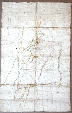
1 – Map clippings from three different maps are shown: A) Applications for Land Grants, Volume 1, Page 17 of Series A0272, New York State Archives; B) Draught of Fordham and the Meadow [1669] from Minutes of the Executive Council of the Province of New York edited by Victor Hugo Paltsists, opposite p. 195; and C) The Land of John Archer Layd Downe acording to his Pattent by Phillip Welles surveyd  July 6th 1684, 3080 Akers. The Collegiate Churches of New York.

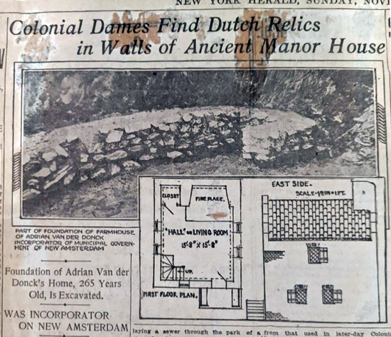
2 – New York Herald, Sunday November 9, 1913.

3 – Jenkins, Stephen. The Story of the Bronx from the Purchase Made by the Dutch from the Indians in 1639 to the Present Day. G.P. Putnam’s Sons, 1912, p. 301.

4 – Pons, Luis. Van Cortlandt Park History.  Administrator’s Office, Van Cortlandt & Pelham Bay Parks City of New York Parks & Recreation, 1986. p. 4.

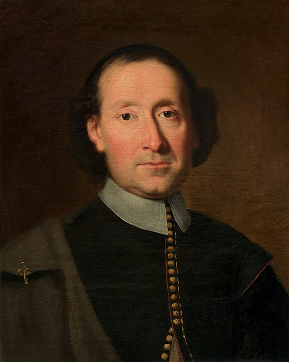
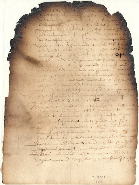
5 – As will be shown, details about events at Colendonck are sketchy.  Much of what is known comes from one document: a 1652 or 1653 petition written by Van der Donck to the Directors of the Dutch West India Company.  That petition still exists in the New York State Archives although it was badly damaged by the infamous New York State Library fire of 1911.  Therefore, the most recent translation is missing quite a lot of original text.  Thankfully, it had been translated prior to the fire and published on p. 408 of Robert Bolton’s 1848 A History of the County of Westchester, from its First Settlement to the Present Time, Vol. 2.  Depending on which translation you look at, you may come away with different conclusions.  The most recent biography of Adriaen van der Donck by J. Van Den Hout, which made use of the more recent incomplete translation, suggests that Van der Donck lived on the bank of the Spuyten Duyvil Creek, which is not in modern Van Cortlandt Park.  However, later land deeds show that this was not possible.  When Van der Donck’s brother-in-law sold the land that would eventually become Van Cortlandt Park in 1670, it was described as including as being formerly “in ye possession and occupation of old Youncker van der Dounck.”  Whereas Van der Donck’s property on the Spuyten Duyvil Creek, the island of Paprinimen, was gifted to George Tippett on a different occasion.

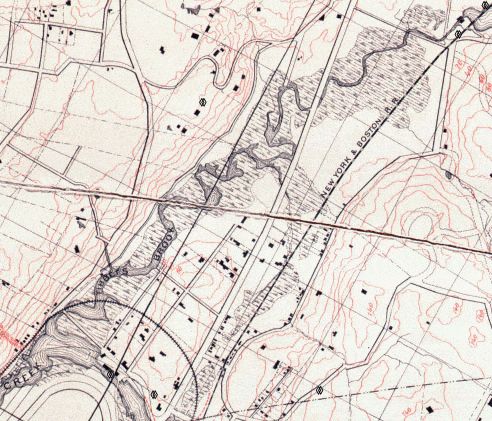
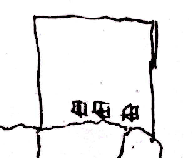
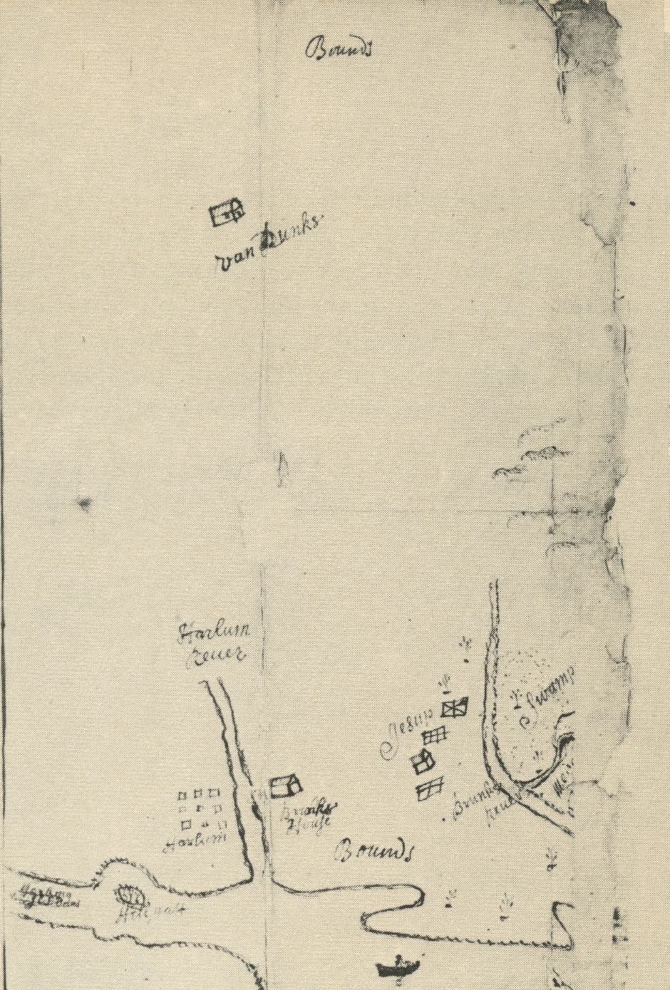
Another early map, when scale is taken into account, gives further indication of the location of Van der Donck’s home.  Georeferencing the below map shows that the home labeled “Van Dunks” would have been located in the vicinity of today’s Van Cortlandt Park (although it is frustratingly lacking in detail).

Applications for Land Grants, Volume 1, Page 17 of Series A0272, New York State Archives

6 – Ibid.

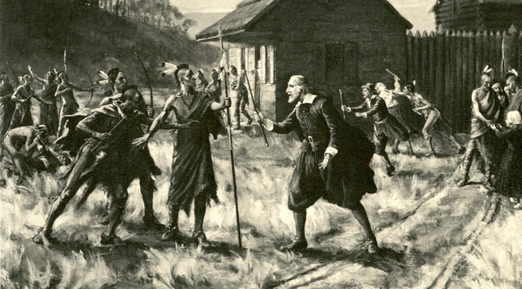
7 –  This attack was part of the so-called “Peach War,” in which a force of Susquehannock fighters and their allies attacked the Dutch colony.  The attack was motivated by the Dutch conquest of a Swedish settlement that had a trading relationship with the Susquehannocks.  There is some evidence to suggest that Van der Donck had good relations with the indigenous people living near Colendonck but it is unlikely that the Susquehannock would have had any idea who he was.

8 – 1652 or 1653 Van der Donck petition.  See note #5.

9 – Van den Hout, Julie. Adriaen van der Donck: A Dutch Rebel in Seventeenth Century America.  Excelsior Editions, 2018. p. 129.
 
10 – ibid, p. 120.
 
11 – Fernow, Berthold. The Minutes of the Orphanmasters of New Amsterdam 1655 to 1663. Francis P. Harper, 1902. p. 10.
 
12 – New Netherland Documents, Council Minutes 1655-1656, translated by Charles Gehring, Syracuse University Press, 1995. [6:253] p. 204.

13 – Fernow, Berthold. The Records of New Amsterdam From 1653 to 1674 Anno Domini. Knickerbocker Press, 1897. Vol II p. 8.

14 – Fort Orange Records 1654-1679. translated and edited by Charles T. Gehring and Janny Venema. Syracuse University Press, 2009. p. 422.

15 – Bankoff, H. Arthur and Winter, Frederick A.  “The Archaeology of Slavery at the Van Cortlandt Plantation in The Bronx, New York.” International Journal of Historical Archaeology, Vol. 9, No. 4 (December 2005). p. 294.

16 – Van den Hout. p. 95.  As a side note, it does not appear that Van der Donck’s contemporary, Jonas Bronck, utilized slave labor on his nearby farm.

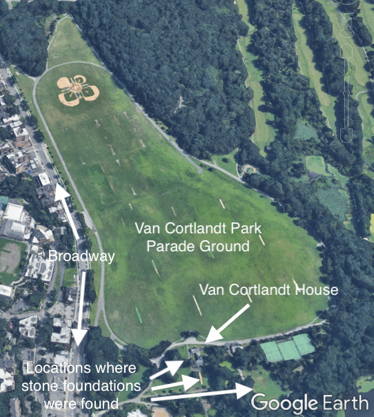
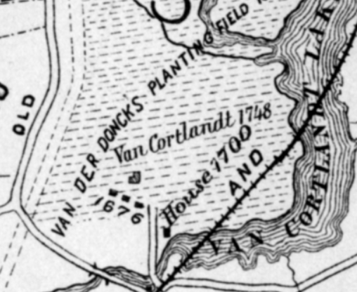
17 – Thomas Henry Edsall, author of the 1887 History of the Town of Kings Bridge, drew a  “Historical Sketch Map” of the Kingsbridge area, which depicts three home sites just south of the Van Cortlandt House Museum (labeled 1676).  He did not offer any explanation of how he came to determine that there were structures in that location.  It is interesting to note that he drew this map before any of the 17th-century stone foundations were found in the area.

18 – Minutes of the Executive Council of the Province of New York.  edited by Victor Hugo Paltsis.  Vol I, p. 201.

20 – Ibid. p. 211 and beyond.

21 – Ibid. p. 206.  Same property that was sold to Hadley in Westchester Deeds B 94.

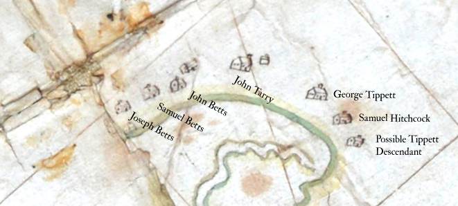
22 – Will and Testament of William Betts, 1675.  He wrote: “I give and bequeath unto my wife Alice Betts, after my decease, my House and House Lott, with the Barne and all the Meadow that is lying by my House Lott, now in Possession; Also one third part of my Land in the Planting ffield within ffence, All which are Scituate in the younckers Plantation.”

23 – It is also entirely possible that Van der Donck’s home, or perhaps its foundation, was repurposed by one of the English colonists that arrived 12 years later.

24 – References to:

  • Orchards: Westchester Deeds Liber A, p. 203; Liber B, p. 94; etc.
  • Cattle: Westchester Deeds Liber B, p. 90;
  • Burial Ground: Westchester Deeds Liber E, p. 147; For additional documentation, see also
  • Commonage for grazing and timber: Westchester Deeds Liber B, p. 91; Liber D, p. 13; etc.
  • Blockhouse: “Petition of Inhabitants of Yonkers, Praying to be Excused from Joining the People of Fordham in case of an Indian Invasion,” Brodhead, John Romeyn Documents relative to the colonial history of the state of New-York: procured in Holland, England, and France.  Weed, Parsons, 1853-1887. Vol. 13 p. 492
  • Paths and Roads: Westchester Deeds Liber A, p. 203; Liber B, p. 94; Liber B, p. 114; etc.

25 – Estate Inventory of George Tippits of Younkers by Thomas Huntt, William Hayden, Edward Griffin of Flushing – September 29, 1675.  In the 18th and early 19th centuries, the Van Cortlandts and other local farmers held larger numbers of enslaved people.  See here.

26 – “Inhabitants of Fordham and Adjacent Places.” New York Genealogical and Biographical Record Vols. 38-39, New York Genealogical and Biographical Society, 1907. p. 218.

27 – Westchester Deeds Liber B, p. 223.

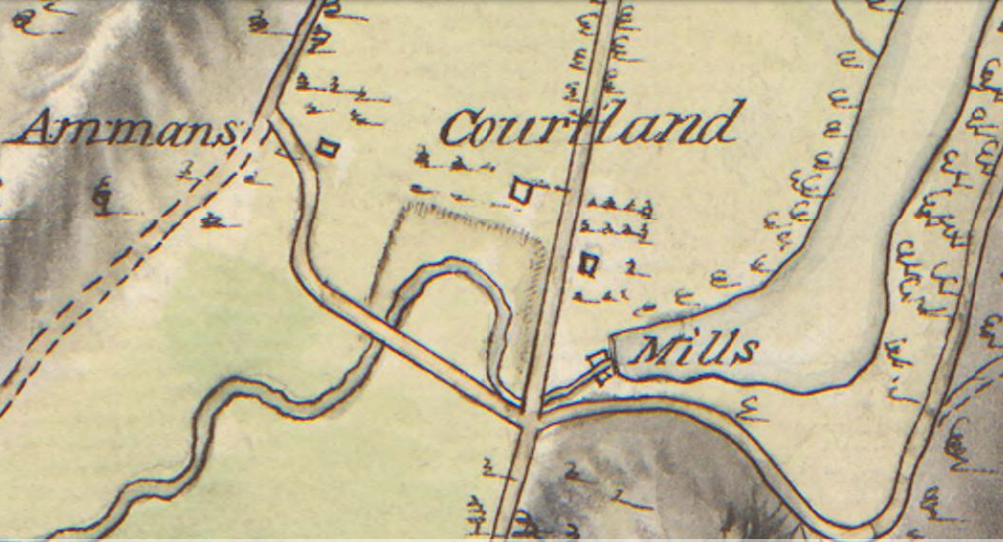
28 – Westchester Deeds Liber D, p. 13

29 – The 1781 map of the area depicts a house to the west of the Van Cortlandt house labeled “Ammans.”  This could be the former home of Joseph Betts.  His widow, Alice Betts, married Abraham Emmons.  The house to the east of the Van Cortlandt house previously could have been the home lot of George Tippett III, who sold his “home lott” to Jacobus van Cortlandt in 1732 (Westchester deeds Liber G, p.

30 – “Old Indian Relics.” New-York Daily Tribune, December 14, 1890.

31 – Bankoff, Arthur H., and Winter, Frederick A.  Van Cortlandt House Excavations 1990 and 1991. p. 10.