Home › Forums › The Industrial Era › 19th Century Composite Map of Riverdale
- This topic has 5 replies, 3 voices, and was last updated 1 year, 10 months ago by
COGGINSS.
-
AuthorPosts
-
-
June 10, 2020 at 5:59 pm #1474
I am working on posting another JB James memoir of Riverdale but I am having some trouble understanding the locations that he described. To better understand it, I am overlaying some 19th century property maps over contemporary ones. The first map overlay I did was an 1853 map with the below caption:

Here is the overlay (the blue bar on the top right allows you to adjust the transparency of the overlay and you can zoom in and out):
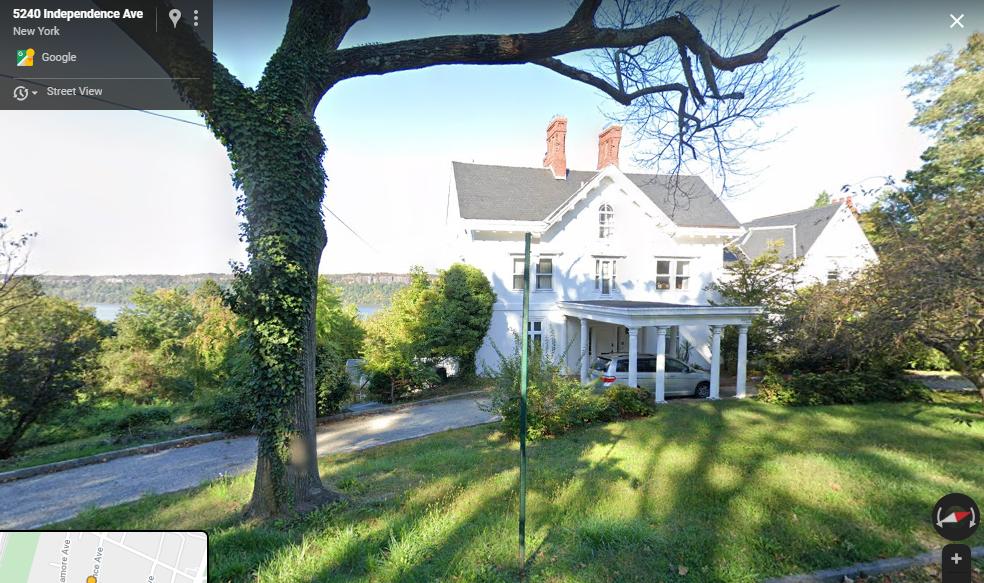
If you zoom in to what is today Independence Ave (formerly Palisade Ave) between 254th and 252nd Streets, there are a row of old homes on the western side of the street. It is hard to get a good look at most of them because of hedges and trees but one (5247 Independence) can be clearly seen from the street:
It would be interesting to get a better look at some of these old homes and find out something about the original owners.
-
June 10, 2020 at 7:09 pm #1475
I’ve always loved this house! It’s the Henry Atherton estate, built in 1853. There’s a lot of info on it here (page 53):
http://npclibrary.org/db/bb_files/1990-riverdalehd.pdf
Also, just looked it up and its for sale! (start saving your pennies) https://www.zillow.com/homedetails/5247-Independence-Ave-Bronx-NY-10471/29854467_zpid/
-
June 11, 2020 at 5:08 pm #1476
Thanks for the info. Definitely good to have a copy of the Riverdale Historic District document. As for the house, I have to say it sure beats a lot of the McMansions that were recently built in Fieldston–and what a view! Anyone want to buy it and donate it to the KHS as a new headquarters?
J.B. James’ memoir includes information on another old house in the area:
There was also a very old farm house on the extreme southwest corner of the land, now the grounds of the Colored Orphan Asylum, which was run for many years by a Mr. Whitney as a boarding house. This was also destroyed. It may have been the original Ackerman house, but I think it was the old Warner house.
If JB James remembers this old house, there is chance a photo of it could be found. And if it was the original Warner house, it would be very old indeed. Who was Warner? There were generations of Warners that owned a great deal of property in this part of Riverdale. But before they owned the land, they were tenant farmers renting the land from Frederick Philipse as this part of Riverdale was part of Philipsburg Manor, which stretched from here to the Croton River. John Warner was a capable Patriot militia officer during the Revolution. He served as 2nd Lieutenant and later as Captain of the South Yonkers company of militia that hailed from this neighborhood. He was from the 3rd generation of Warners to live in the neighborhood. His father William and Grandfather Charles both farmed this same spot. After the Revolution, Frederick Philipse’s property was seized by the state and the Warners purchased the farms that they once rented.
According to JB James, the house was on the grounds of The Colored Orphan Asylum, where the Hebrew Home is today on the banks of the Hudson. According to this map from the Revolution, there was a house belonging to Warner on the banks of the river:
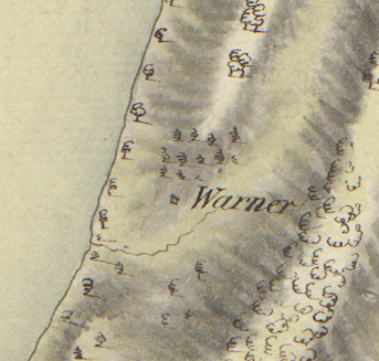
The above snippet shows the house just north of a stream feeding into the Hudson. A rarely seen property map from 1837 gives the area in greater detail.
The slider on the top right adjusts opacity and you should be able to zoom in.
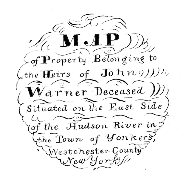
The southern edge of this property borders on the property that is depicted in my previous post (the map with the Henry Atherton estate house that is currently for sale). The southwest corner of this map fits like a puzzle piece into the northwest corner of that map. This map is dated 1837 and includes the following label:
The notch of land on the southwest corner gets its shape from a stream. I believe this is the same stream that is visible in the map from the Revolution. A little bit to the north you will see a “Dock” and three “dwelling houses.” One of these is the house that J.B. James is referring to and they indeed belonged to the Warners. This land is currently on the grounds of the Hebrew Home. Interestingly, one of those houses seems to have a similar footprint to an existing building. It would be interesting to see if photos from the days of the Colored Orphan Asylum could be found to reveal what these old houses looked like.
The property map reveals some other interesting things. Any local maps from this period (1st half of the 19th century) are very rare. To my knowledge, there were no commercially published maps of the area in this time. You can see that there is a bit of land that juts out into the Hudson today in exact same spot where the dock was located. You can also see that part of Palisades Avenue was indeed a very old road. You can also see the “quarry” labeled on the map where the Skyview apartments are today. I found the will of John Warner and he was convinced that this quarry was going to yield a fortune.
I am trying to put these property maps together to make a composite map of Riverdale for this time period but it is loading very slowly. I put the Atherton map and the Warner map together here if you are interested and patient enough for it to load.
-
June 19, 2020 at 8:16 pm #1478
Another old house that J.B. James refers to in his memoir is the “Samler House.” In 1935 he wrote:
Another old timer was the [S]amler house, at the junction of Albany Post Road with Broadway at about 254th St. The house was in the old Dutch style, with a long sloping roof covering the porch. A grape arbor, with a brick path ran from the house to the road. The grounds were 17 acres of hilly, picturesque land, and a row of fine old cherry trees stood along the road front. Many a feast I have had on their fruit. The farm had several large shag-back hickory nut trees, a great rarity now. These nuts are the finest flavored of any nut that grows. The trees were cut down for firewood before we left Riverdale. The old house still stands, but was moved westward about one block and fitted with modern improvements.
I have seen references to this house before. The Reverend Tieck mentioned it only briefly on p. 154 of Riverdale, Kingsbridge, Spuyten Duyvil:
About 350 feet north by west of the point where the Henry Hudson Parkway crosses Broadway stands a very old white frame dwelling, the Samler house, now slightly west of its original location.
So the house was still there W. 254th Street and Post Road when Tieck was writing–in 1968.
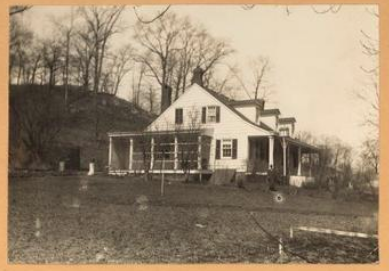
There are photos of the house at the NYPL and the New York Heritage site. This one was taken in 1924.
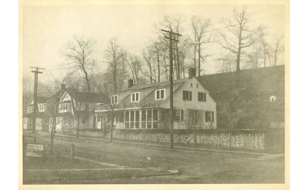
It does have the classic look of an old NY Dutch farmhouse from the colonial period. This is that same view today.
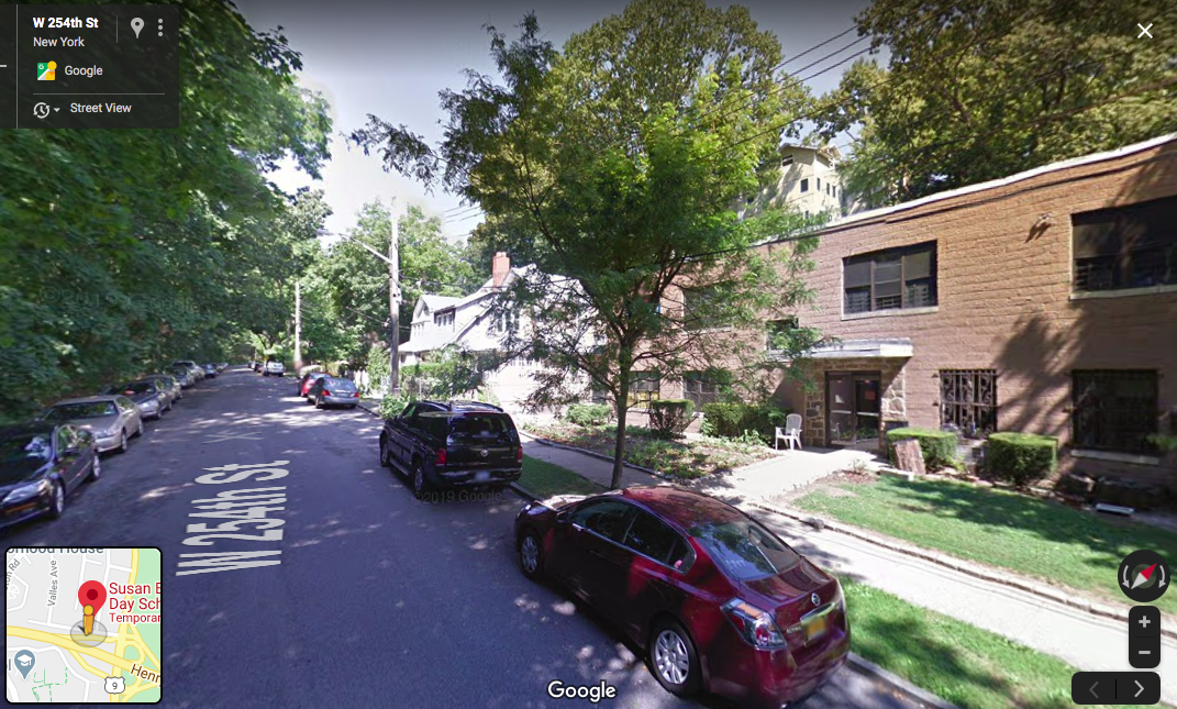
There is a charmless looking concrete box on the site now but the same single family homes can be seen in the distance. I found out that this concrete building was built in 1978 to house the “Fielday” preschool:
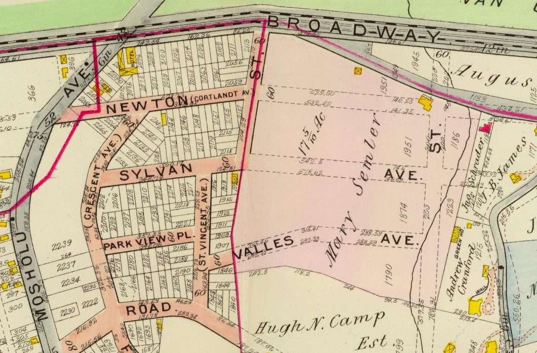
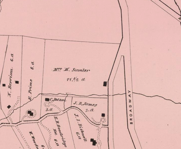
Both James and Tieck referred to the Samler House as “old” and state that it had been moved but offered no dates. I got curious about the history of the building. This very cool 1907 map of Riverdale shows the house on a plot shaded pink and labeled “Mary Semler.” This is before it was moved–fronting on the Albany Post Road–not far from J.B. James own house to the east and it shows the Samler farm as being 17.5 acres.
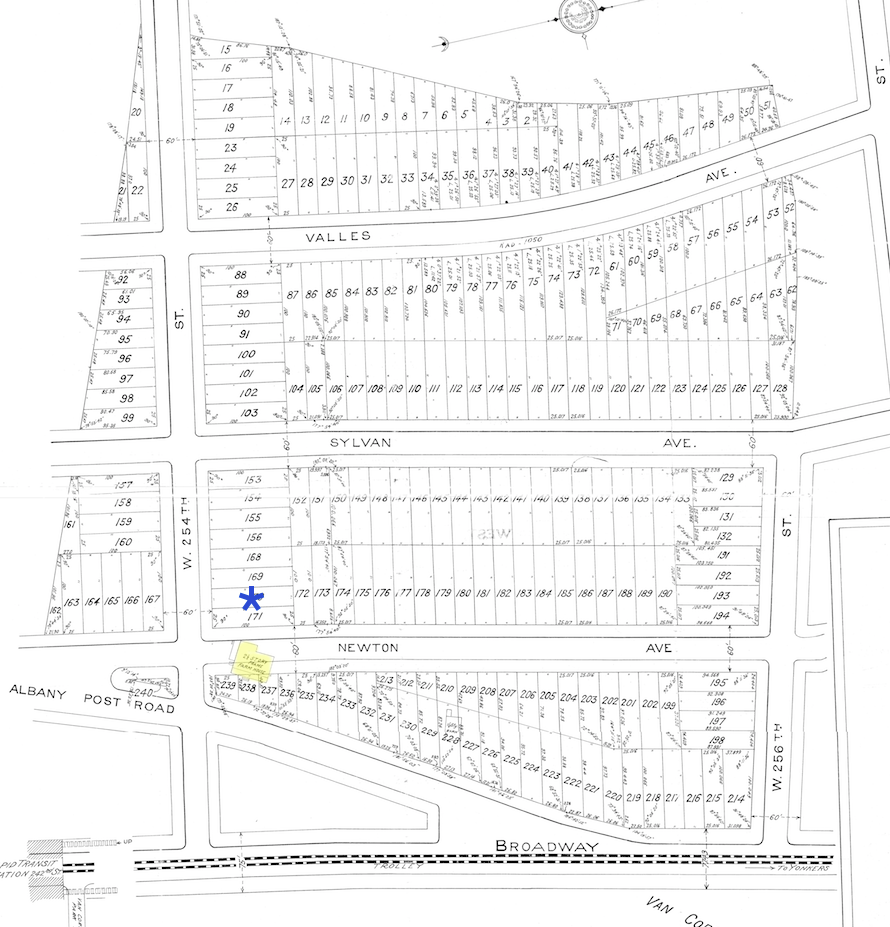
The property was sold not long after that map was made. The below map (estate sale map of the Samler farm) shows where the house was in yellow and where it was moved to (marked with a blue asterisk).
So the house was not moved very far at all. Who was Mary Samler? Googling around reveals that she was the daughter of George Washington Hadley, which explains a lot. The Hadley family’s connection to this neighborhood predates the Van Cortlandt’s presence here. In fact, the Van Cortlandt House probably sits on land that previously belonged to the Hadleys. Digging into Mary Samler’s ancestry a little I found that she was a descendant of many of the local colonial era families (Tippett, Betts, Warner, etc). So it at least seems to offer the possibility that the house was indeed “old” as J.B. James and Rev. Tieck suggested.
Cross Checking the location of the house on an earlier map indicates that the Samler house was just north of a stream that fed into Turtle Brook (an old stream that crossed the parade ground of Van Cortlandt Park):
Now check out a zoomed out view of the same location on this 1781 British Intelligence Map:
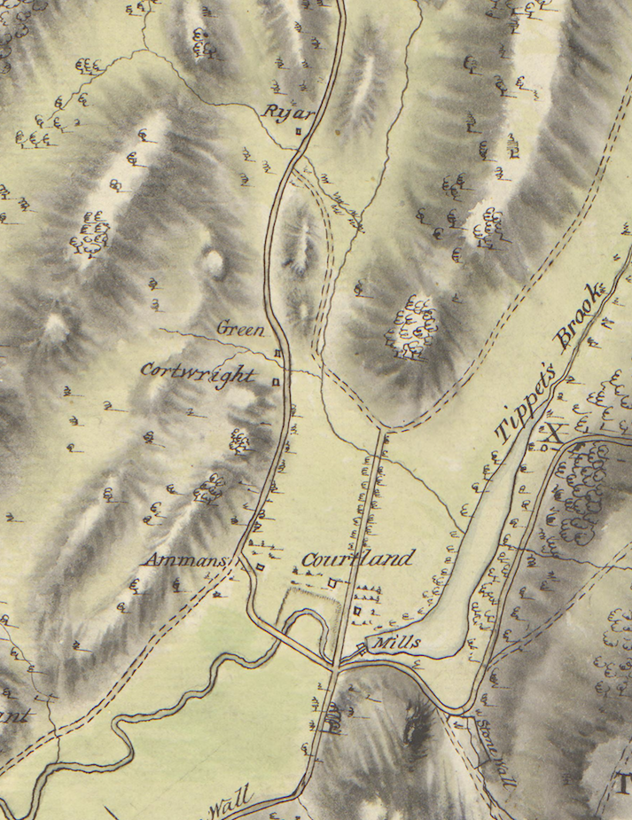
The road that runs north to south down the middle is the Albany Post Road. “Courtland” is the Van Cortlandt House. The house labeled “Green” is THE Hadley House that still stands at 5122 Post Road. To the north of that is a house labeled “Ryar” that stands just to the west of the Albany Post Road and just north of a creek–a dead ringer for the location of the Samler House.
If this is the same house, who was “Ryar?” This part of Riverdale from 1693 until the Revolution was part of Philipsburg Manor. In 1693, the land was granted in a royal proclamation to Frederick Philipse, who became “Lord” of the manor. During the Revolution Frederick Philipse III, who was the Lord of the manor at that time, paid a large price for his loyalty to King George IIII. His lands were forfeited to the new American government and they were sold by the Commissioners of Forfeiture in 1785-1786. Before then, the manor was divided up and farmed by tenants, who paid annual rent to Philipse. Ryer was one of those tenants. The Westchester County Archives has the records of the sales that occurred under the Commissioners of Forfeiture and this is the relevant one:
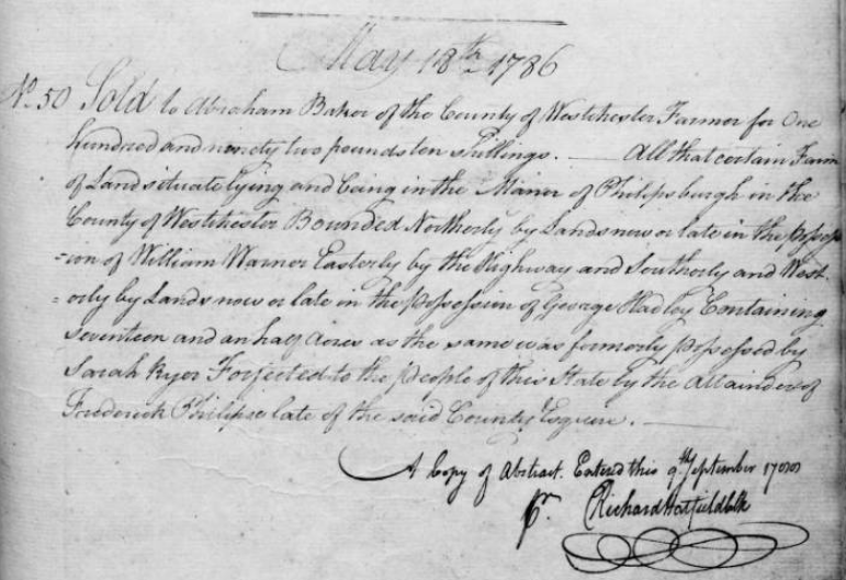 It reads: “No. 50 Sold to Abraham Baker of the County of Westchester Farmer for One hundred and ninety two pounds ten shillings. All that certain Farm of Land situate lying and being in the Manor of Philipsburgh in the County of Westchester Bounded Northerly by Lands now or late in the possession of William Warner Easterly by the Highway and Southerly and Westerly by Lands now or late in the possession of George Hadley Containing seventeen and a half Acres as the same was formerly possessed by Sarah Ryer Forfeited to the people of this State by the Attainder of Frederick Philipse late of the said County Esquire.”
Note that the acreage of the farm is the same as it was in the 20th century–17.5 acres. Other than the above document it is difficult to figure out what members of the Ryers family were living there before the Revolution. They were a Dutch family, which means that had different naming conventions and their ancestry is confusing–but it explains the Dutch colonial architecture of the Samler House.
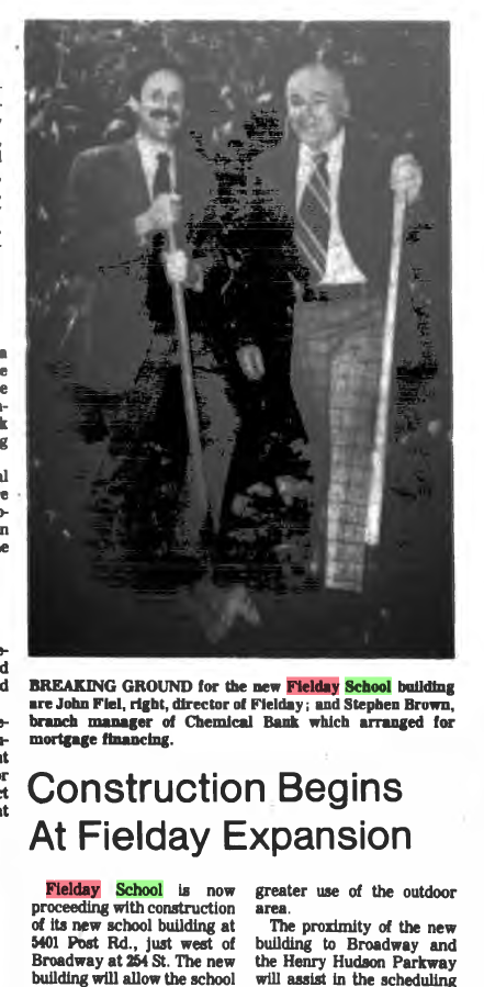
I could not figure out when the Samler House was torn down but it had to be before 1978 when the Fielday School building was built. I found a reference to the address, 225 W. 254th Street, in this 1963 blurb but other than that, nothing in the Riverdale Press:
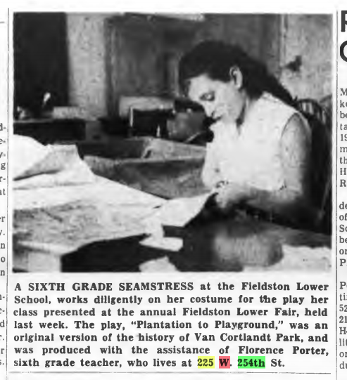
I find the idea of this teacher, Florence Porter, living in a local historic house and teaching local history fascinating. I wonder if she knew the history of the home that she lived in.
I also wonder if the house was torn down, burned down, or what. If local historians were vaguely aware of its history, I wonder if anyone opposed its destruction.
-
June 30, 2020 at 6:34 pm #1502
I just transcribed and uploaded another of J.B. James recollections of old Riverdale, Kingsbridge, and Spuyten Duyvil. I included a bunch of great photos too. It has some interesting stuff about how horrible the trains were to ride in the early days. It also contains a lot of info on the colonial-era houses of the neighborhood (a few of which I referred to in this thread). It is amazing how many of them survived the Revolution only to be torn down in the 20th century. There is also a interesting nugget of information at the very end concerning a burial ground for enslaved people in Van Cortlandt Park. According to James, “a great number of skeletons of former slaves of the Estate were unearthed.” This is the first time I have ever read an attempt to describe the number of skeletons that were exhumed when the railroad was built.
-
September 2, 2024 at 4:48 pm #4374
 An Estate Marker and Gate in Riverdale Park
-
-
AuthorPosts
- You must be logged in to reply to this topic.