Home › Forums › 20th Century › Ethical Culture Fieldston Campus and Lincoln’s Collector
- This topic has 10 replies, 6 voices, and was last updated 1 year, 4 months ago by
kirkatude.
-
AuthorPosts
-
-
June 26, 2021 at 12:37 am #2021
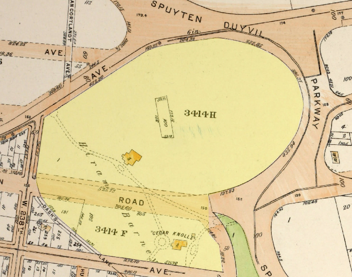
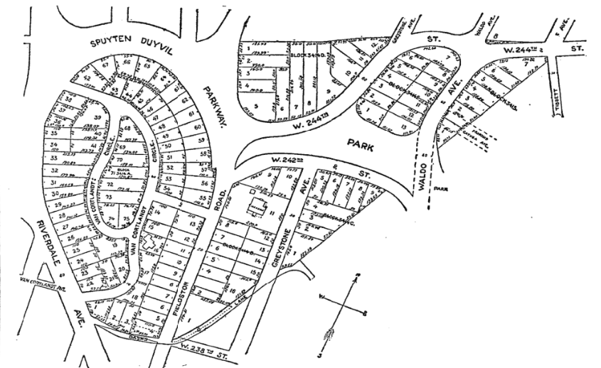
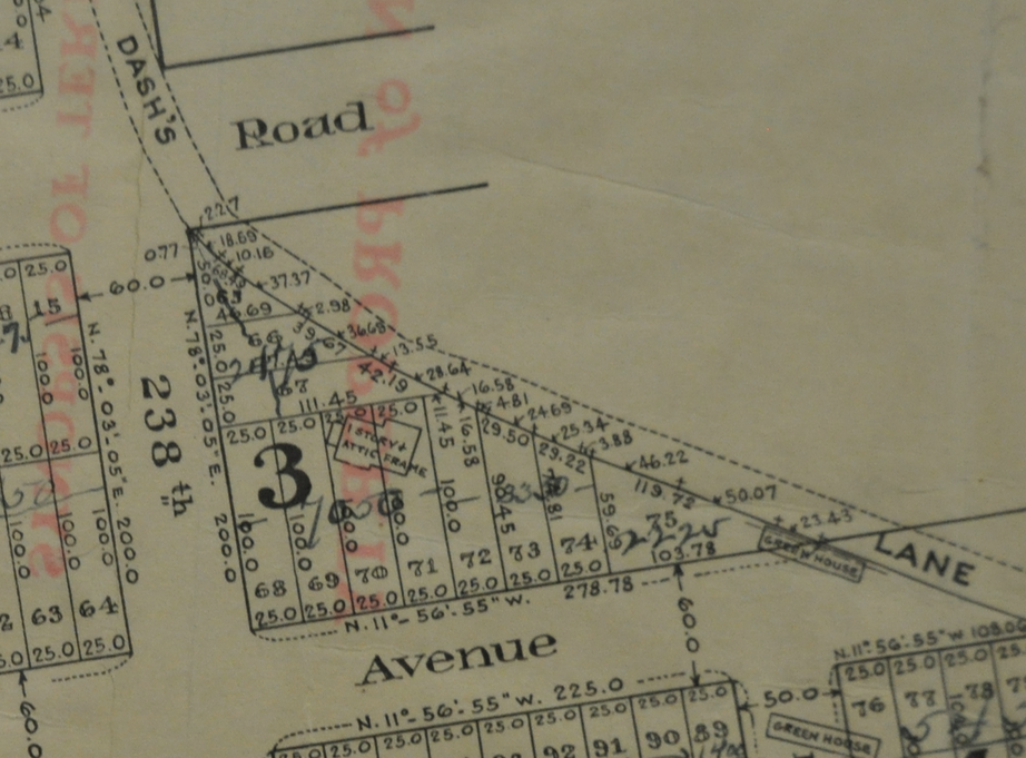
I received an email inquiry that I found interesting. The sender was wondering about this 1921 map and wanted to know about the buildings that once stood on the campus of today’s Fieldston School. Below is a snippet from the map and the campus is highlighted in yellow:
[caption id="" align="alignright" width="386"]
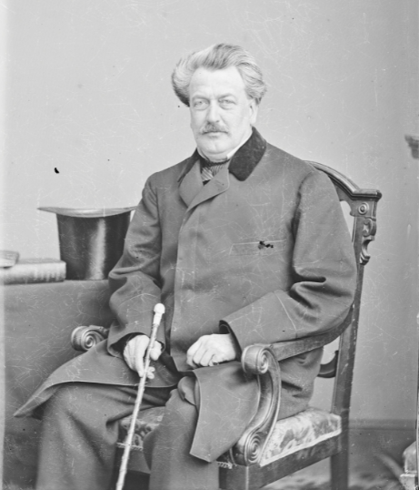 Hiram Barney, National Portrait Gallery, Smithsonian Institution; Frederick Hill Meserve Collection[/caption]
The first thing you might notice is that there is no “Spuyten Duyvil Parkway” curling around the campus anymore. That is called Manhattan College Parkway now. Fieldston Road appears as a mapped street crossing the campus in a straight line on the map, which it does not do today. There are two buildings depicted on the property and one is labelled “Cedar Knolls.” In addition, there are two lots mapped out in thin black lines with marked dimensions. One is a rectangular lot smack in the middle of the campus and the other is a triangular lot on the lower left along “Dash’s Lane.” While “Dash’s Lane” no longer exists as a path, it has the same boundary as the rock wall behind Trebach Realty on Greystone Ave. The entire campus has the name “Hiram Barney” printed over it.
Hiram Barney is an interesting figure and “Cedar Knolls” was his country estate. He was a lawyer, abolitionist, and an advisor to and correspondent with President Lincoln. During Lincoln’s administration, he served as the Collector of the Port of New York. This was a federal office and he was appointed to the position by Lincoln. The Port of New York was a very big deal in those days. Before that, he was the chair of the executive committee of the Young Men’s Anti-Slavery Society in New York City and was nominated to Congress by the Anti-Slavery Party. His Cedar Knolls mansion was about where the lower school is today abutting Greystone Ave and dates from the mid 1800s, when the area was still part of Yonkers:
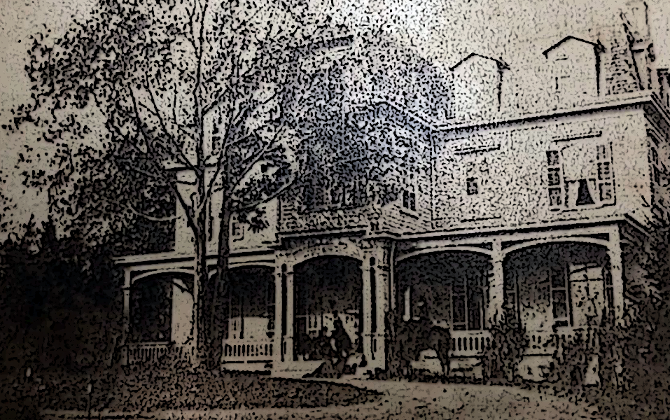 “Cedar Knolls” mansion, country seat of Hiram Barney on today’s Fieldston campus.
The other building depicted on the Barney property (about where the cafeteria building is now on the Fieldston campus) could have been a caretaker’s cottage or perhaps it belonged to a previous owner. I’ll have to dig a little deeper to find out the story with that one.
In 1872, the neighborhood declared its independence from the City of Yonkers and needed a name for the new municipality. A meeting was held at Mosholu Hall and it looks like Hiram Barney might have been the chair–not a surprise given the prestige of his post and connections:
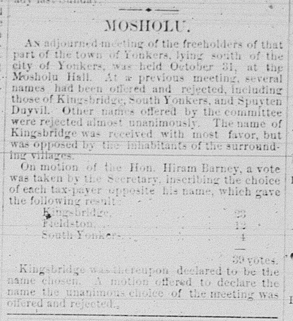
The town would be called Kingsbridge and it was independent for one year before being annexed by NYC. Barney died in the neighborhood in 1895.
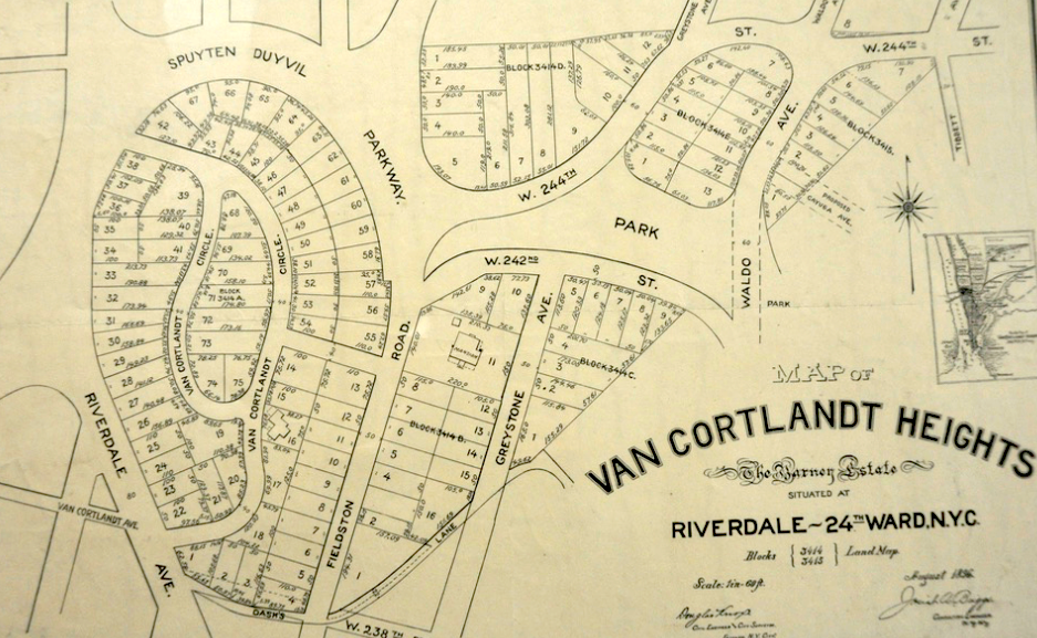
His estate was divided into lots and put up for auction in 1899. This auction map appeared in the New York Times:
…But the rocky ground garnered little interest (from the 7/13/1899 NY Journal):
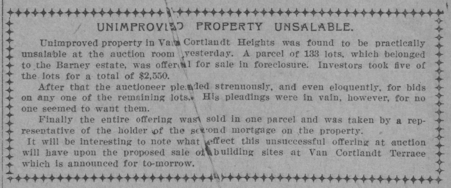
So that weird rectangular lot that appears in the middle of campus on the 1921 map was probably one of the few lots that sold at the auction–same with the triangular lot on Dash’s Lane. That’s the story behind the buildings and odd lots on the 1921 map.
-
June 26, 2021 at 1:39 am #2022
Wow – interesting. I know that Spuyten Duyvil Parkway’s name change din the 1950s and thought the whole area southward was known as Spuyten Duyvil. So, if the name Kingsbridge was rejected at Barney’s meeting, what name was decided for the area? It sounds like Van Cortlandt Heights may have been the name for the area we now call Riverdale and Spuyten Duyvil? Is that true? Also, my family home; NW corner of W 238th & Greystone had the name “Waldo Hutchinson Estate” written on the land’s map associated with the property survey and deed. I am surprised that this name does not appear on the map. Any thoughts?
-
June 26, 2021 at 2:19 am #2023
The name Kingsbridge actually did receive the most votes at that 1872 meeting so that is the name that was chosen as the official name of the municipality, which included the neighborhoods of Fieldston, Riverdale and Spuyten Duvyil.
Van Cortlandt Heights was the name given to the land of the Hiram Barney Estate when it was divided up into lots and put up for Auction. I would imagine the auctioneer came up with that one:
And your family’s property on the northeast corner of 238th and Greystone would have been on the other side of “Dash’s Lane” so not part of Barney’s property. It belonged to Barney’s neighbor Waldo Hutchins. The Hutchins estate was put up for auction in 1909:
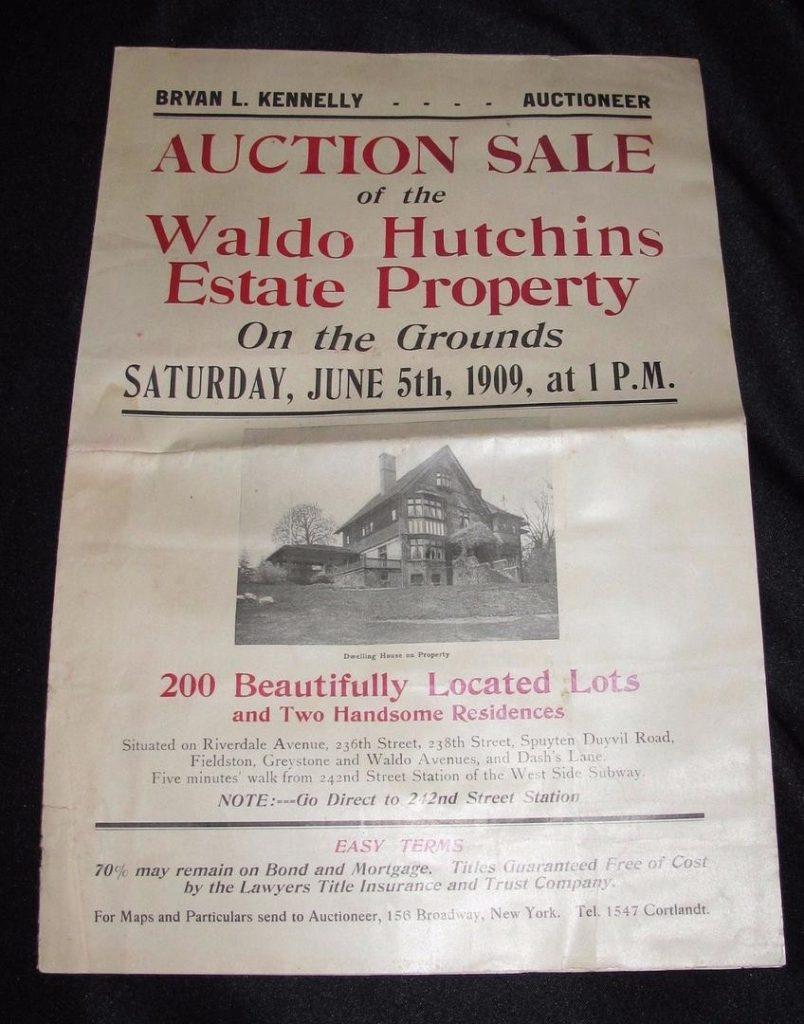
You can see your family’s former property the Waldo Hutchins Estate Auction Map:
And the Dash estate also sold in 1909, I believe. The neighborhood went from being large sweeping country estates to small lots with modest homes in a very short period of time. Rapid transit spurred this on it seems (from the Hutchins estate brochure):

-
June 26, 2021 at 9:12 pm #2024
This posting raises some very interesting questions about the origins of the Spuyten Duyvil Parkway. Was it originally a scenic avenue to a park, comparable to Olmsted and Vaux’s Ocean Parkway and Eastern Parkway in Brooklyn? When and why was it constructed and named? What entities or people promoted its construction and design? Did it run from south to north from Spuyten Duyvil (somewhere around Kappock) to Fieldston, and then loop around the northern side of what’s now the Fieldston School area and then the southern side of the Manhattan College Campus to reach Broadway around 242nd Street?
I’m guessing that the south to north axis was widened and transformed in the 1930s to become the Henry Hudson Parkway, and that the Henry Hudson Parkway was re-routed northward to join the Saw Mill and Mosholu Parkways in the northern half of Van Cortlandt Park. The remaining portion of the Spuyten Duyvil Parkway (the west-east portion) would have been left as a scenic two-lane avenue with no median, and it was eventually re-named as Manhattan College Parkway because it no longer came from, or led to, Spuyten Duyvil. -
June 30, 2021 at 3:49 am #2025
Fascinating history. Thanks, Nick! o that’s how Kingsbridge became an official name. I’m sorry to see “Spuyten Duyvil” disappear from the road’s name, but as Bronxologist notes, I guess it didn’t really lead to Spuyten Duyvil anymore.
-
June 30, 2021 at 4:33 am #2026
Here’s another map; this one from 1881. You get an idea of what they were planning for Spuyten Duyvil Parkway in this area. Today’s Brust Park and the pedestrian/bike path next to the Manhattan College Student Center were all supposed to be part of Spuyten Duyvil Parkway:
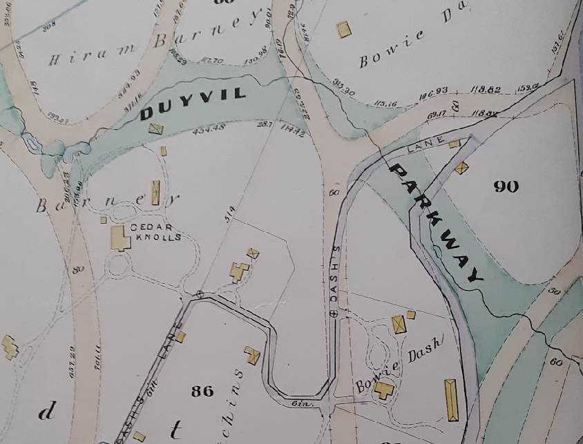
The parkway followed the course of Stony Brook. It looks like the City acquired that land in an unusual manner, perhaps condemnation, from Hiram Barney as Barney filed a claim against the City as did other neighborhood residents (from the 1/20/1883 City Record):
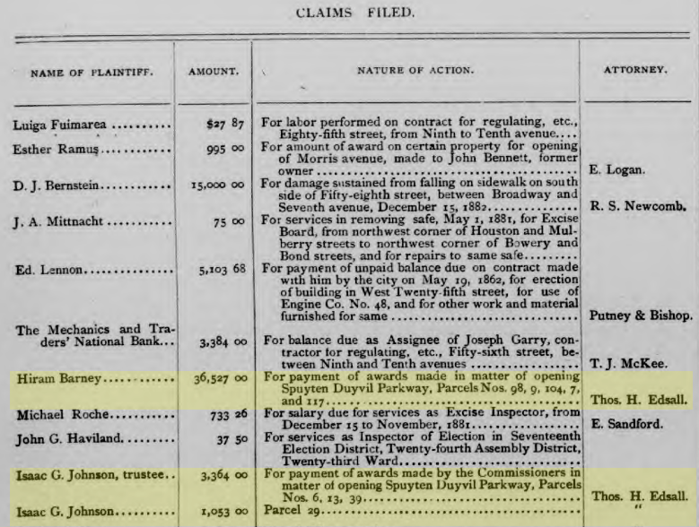
Interesting to see that the neighborhood folks seeking claims from the city were represented by Thomas Henry Edsall, the area’s first local historian.
-
June 30, 2021 at 6:47 am #2027
Bronxologist asks … Spuyten Duyvil Parkway, was it originally a scenic avenue to a park, comparable to Olmsted and Vaux’s Ocean Parkway and Eastern Parkway in Brooklyn? Since Olmsted and Vaux designed many or all of the sweeping roads in Riverdale, against City Hall that wanted the Grid System in the Bronx, it is a small miracle that so many of their street designs are still with us.
-
September 10, 2021 at 7:20 pm #2150
An employee at the Ethical Culture Fieldson School, Kirk Ruebenson, made these map sliders using the NYPL map warper tool. Drag the arrow slider to compare maps–pretty nifty!
-
March 11, 2025 at 3:24 pm #4673
Is there a better photo of Hiriam Barneys “Cedar Knolls” estate? Also, is there any way of finding out exactly how The Society for Ethical Culture came to purchase the property as a whole? It seems as though the second “morgagee” bought it. Who would that have been, and how did the Society find out? I know Clarence Stein, the architect of Fieldston, along with Robert Kohn, was working in the Parks Dept. about the same time as Robert Moses was. Any connection?
-
March 11, 2025 at 6:21 pm #4674
You should be able to order a better copy of Hiram Barney’s Cedar Knolls property from “Historic New England.” Here is the link to the Barney photo album in their collection:
https://www.historicnewengland.org/explore/collections-access/gusn/285244
The Huntington Library (the California one, not the Bronx one) has the Hiram Barney papers which apparently includes information about his New York real estate:
https://oac.cdlib.org/findaid/ark:/13030/tf658004sg/
The results from these large real estate auctions were often written up in the newspapers so you might want to search for newspaper reports from the time to find out how the whole estate ended up in the hands of the Ethical Culture Society.
One thing I didn’t mention in the thread above is that Hiram Barney wrote about meeting Lincoln before the Emancipation Proclamation. It is a fascinating account:
On the morning of the 5th of September I862, Colonel John Hay
the Private Secretary of the President came to me while at breakfast at
Willards Hotel and asked when I intended to leave Washington. I re-
plied that I intended to go home by the evening train of that day. He
said that the President had sent him to request that I would see him before
leaving the the city. I promised to call at the Executive Mansion between
the hours of one and two o’clock.When I called in fulfillment of the appointment, Louis the door keeper
said “the president expects you but he has gone to the Navy department
and wishes you to find him in Mr Wells’ private room.” He was with
Mr Wells when I opened the door and I thinking I might be interrupting
a private conversation I apologized and was withdrawing, when both
said “come in come in” and Mr Lincoln said “We have no secrets from
you.” We sat in conversation upon topics of general interest for a few
minutes, when Mr Lincoln laid his hand upon my knee and said “I want
to see you”-and added, rising “Come with me.” I followed him to the
War Department-he walked very rapidly-so fast that I had to trot
to keep up with him. The Secretary of War had three private rooms-we
entered the first-no one was there. Mr Lincoln closed the door and we
went into the second which was also unoccupied, and Mr Lincoln closed
the door of that room also-we then proceeded to the third room the
door of which was also closed when the President said, “There, now
I think we will not be interrupted”-and added, “I have something to
show you which I think will please you.’ He then drew from the left
breast pocket of the dress frock coat which he wore a manuscript and
read it to me. It was his first emancipation proclamation. When he had
read it he handed it to me to examine. I looked it over and saw that it was
all in his own hand writing with which I was familiar. I then returned
it to him remarking upon its character and upon the consequences of its
promulgation and expressing my gratification that he had come to the
conclusion to which he had been so long urged by many earnest patriots.
I then asked him to read it again. He said “you must not talk about this
-for no human being but yourself has seen it or knows anything about
it.” I said “I thank you for this confidence and you may be sure that I
will respect it. My object in asking you to read it again is to offer
one or two suggestions if I heard aright. He said he would be very
thankful for any suggestions and immediately read it again. I offered
only one suggestion which he said he approved and would adopt-it was
the only change from the draft that I recognized in the proclamation
which was issued on the 22nd of September. -
March 13, 2025 at 3:01 pm #4675
Unfortunately, the Barney house photo doesn’t seem to be available online to download. Looks like I’d have to go to Boston! I did know of the Lincoln story, and have some papers from Barney’s archive, if anyone is interested. There is some information on him in the book, “Lincoln at Cooper Union”, by Harold Holzer. It’s kinda a sad story. Kirk
-
-
AuthorPosts
- You must be logged in to reply to this topic.