Home › Forums › 20th Century › Fascinating “Van Cortlandt Swamp” Photos
Tagged: Ray Bromley
- This topic has 16 replies, 6 voices, and was last updated 11 months, 1 week ago by
karlreinsons@gmail.com.
-
AuthorPosts
-
-
March 23, 2022 at 6:37 pm #2716
When the NYC Parks was recently doing work to improve the area by the Van Cortlandt Stadium along Broadway, I talked the construction workers into handing me some of the bottles that they were digging up. They appeared to be from the late 1800s or early 1900s. It all makes sense in light of these photos that Tom Casey recently shared with me courtesy of eBay:
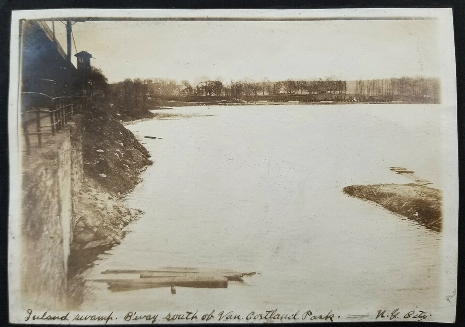
I could hardly believe that label when I saw it but it is accurate. Zooming in, you can see the Van Cortlandt House Museum just to the right of center on the horizon. Here’s another (the view is looking towards Broadway from inside the park from the area north of the stadium):
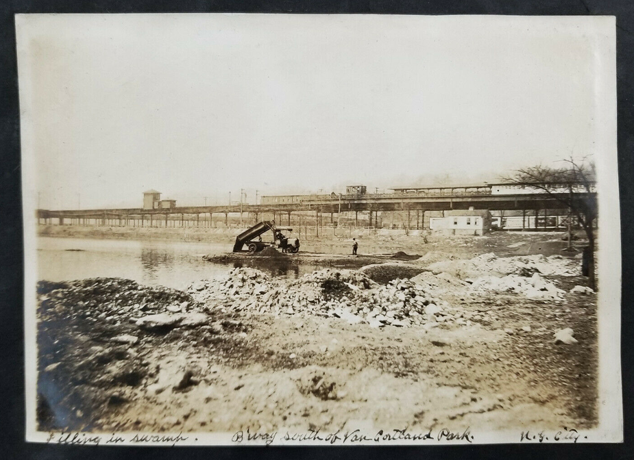
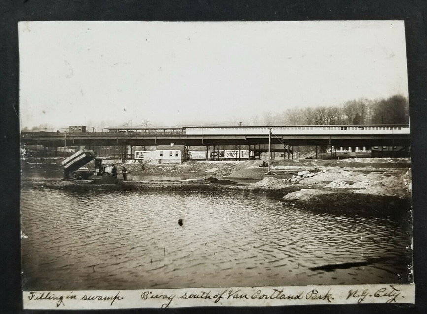
They are using city trash for “Filling in swamp”–hence the bottles dug up by the construction workers recently. Another view:
Here’s one that took me a minute to understand below. This appears to be the view looking to the west on W. 240th Street. Notice the sloped street in the distance. That seems like the paved path that goes from W. 240th and Irwin Avenue to Waldo Avenue today (the one that runs between the train yard and the Manhattan College student center). Over 100 years ago it was a mapped city street.
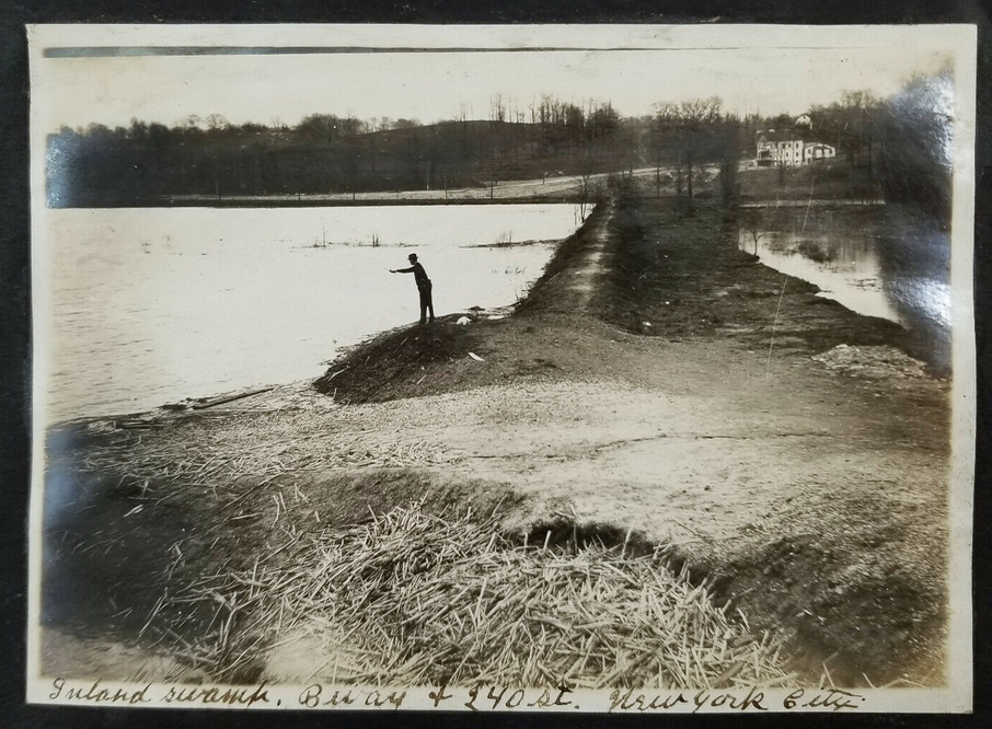
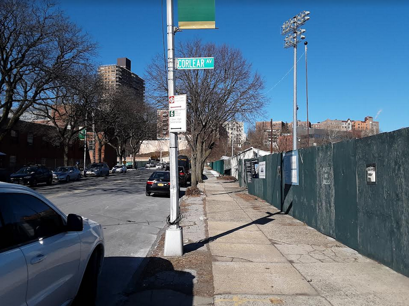
This is that same view today with Gaelic Park on the right (can you imagine fishing here?!):
Other photos in the series make it clear that city trash was being used as fill in various parks at the time:
If you went back in time and told the people in these photos that the City is now talking about daylighting Tibbetts Brook, they would probably laugh at you–after all the work to make the area dry!
-
March 24, 2022 at 2:05 pm #2717
These pictures remind me that as a teenager in the late 1950s I remember finding a bone that was encased in rock? dried mud? south of the Van Cortlandt Putnam RR station and thought I had found some prehistoric creature. My high school biology teacher looked at it and said it was likely a chicken bone thus ending my career as a paleontologist. It was likely part of the garbage dump you describe.
-
March 26, 2022 at 11:40 pm #2718
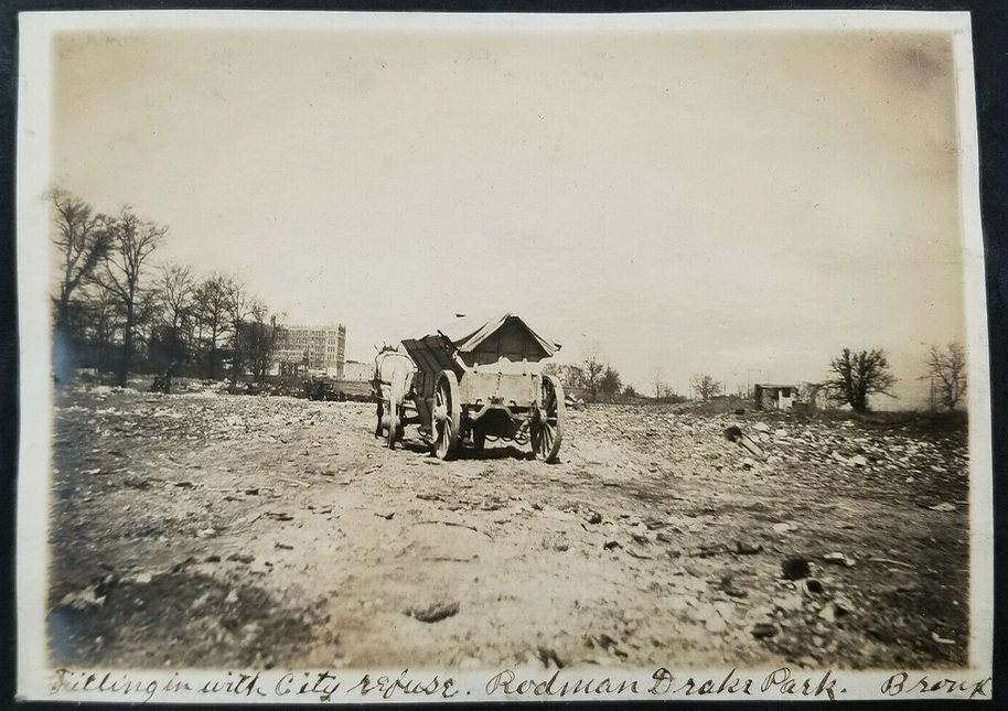
The last photo seems different from the others, all of which are close to the deep south of the current Van Cortlandt Park,three on the east side of Broadway and two on the west side. But the last photo has no hills or obvious landmarks, and it is simply labelled “Filling in with city refuse. Rodman Drake Park Bronx.” Where is or was Rodman Drake Park, and who was Rodman Drake?
-
March 26, 2022 at 11:57 pm #2719
Answering some of the questions that I just posed, I googled Rodman Drake Park and found that it’s located in Hunts Point. Here are the details listed by the NYC Parks Department.
Joseph Rodman Drake Park & Enslaved African Burial Ground Oak Pt. Ave. bet. Hunts Pt. Ave. and Longfellow Ave., Bronx: This text is part of Parks’ Historical Signs Project and can be found posted within the park.
The property of Joseph Rodman Drake Park in the Hunts Point area of the Bronx is located in what was once a Weckquaesgeek Indian settlement. In the late 17th century Thomas Hunt–for whom the neighborhood is named–acquired a large estate that encompassed this modest site, and built his stone residence, “the Grange”, down by the shoreline point.So, this photo isn’t part of the Van Cortlandt and Tibbetts Brook group, but there are some interesting coincidences in relation to Native American Heritage, colonial estates, and the use of garbage and rubble for landfilling.
-
March 27, 2022 at 2:18 pm #2720
Yes, that is correct that the last photo was not local to Van Cortlandt as the other ones were. I included it in the series because of its label, which explicitly states that “city refuse” was the material being used for fill. And to your point, there are some striking similarities between the history of Rodman-Drake Park and Van Cortlandt–both have colonial cemeteries in addition to adjacent cemeteries for enslaved people.
Another part of Van Cortlandt where trash was used as fill is in the area east of Broadway between Mosholu Ave and 260th Street. As a result, the soil is not stable and trees are often uprooted in storms. When they do, you can often find bottles, lumps of coal, and coal ash under the tree roots. No ancient artifacts by any means, but simply interesting trash. Here are a few items from that area that were shown to me:
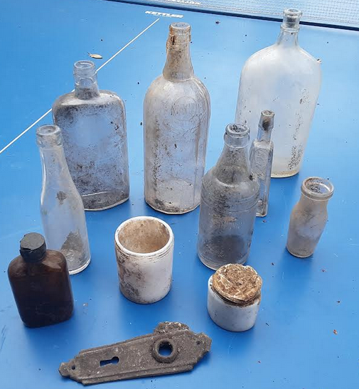
The plastic bottle caps seem to indicate that this stuff is not all that old, I would think. A related fact that I came across in the papers of Harry Emery (a local history enthusiast that grew up in the area in the early 20th century): That this part of the park north of Mosholu Ave is where Israel Russell lived. He was an African American man, who “raised pigs” there and was the “1st garbageman in Riverdale.” I wonder, could he have been collecting trash and dumping it in the park?
-
March 27, 2022 at 3:58 pm #2722
All of these photos are really wonderful! With regard to the image of the bottles, the plastic caps are probably older than you’d think. They were first introduced in the late 1920s. Many of the bottles in the picture are medicinal bottles, including the brown one and the super skinny one, and probably a few others. The opaque white jars were for cold cream or the like. The small wide-mouthed clear bottle was for milk. Thanks for sharing, Nick.
-
February 23, 2023 at 11:44 pm #3282
I think that the view noted as “Inland Swamp. Bway & 240th st. New York City” might be a view looking eastward toward the N.Y. Central railroad tracks and Sedgwick Avenue, not westward. There appears to be a street to the right of the dike that would have been Putnam Avenue East that was lost to the construction of the Major Deegan Highway as were the railroad tracks. I could be wrong…
-
February 24, 2023 at 12:16 am #3283
In the second picture entitled “Filling the swamp. Bway south of Van Cortlandt Park” there is a house partially hidden by the elevated station. To its left and to the right of the billboards is 242nd Street. Under the box shaped support suspended under the station, one block up, can be seen a car. Just to the right of that car is the location of 4652 Spuyten Duyvil Pkwy that was to be constructed in 1923. My parents, sister and I moved there in June of 1937. Further up that road would be the future home of Manhattan College. Just above the cab of the dump truck can be seen the repair barns for the subway cars.
-
February 26, 2023 at 5:07 pm #3286
I need to edit my reply #3282: I should have written “Van Cortlandt Park Ave. West”, not “Sedgwick Avenue”.
-
February 26, 2023 at 6:41 pm #3287
So you think this could be looking east instead of west? I wish I could get a blown up version of the photo but it is not available. But I see what you are saying. There does appear to be a very flat dark line along the bank of the swamp in the distance that could be the Putnam railroad. Do you think you know what date these photos were taken? If yes, we could cross check it against a map from that year. This is after the Broadway elevated line was put in so has to be after 1908.

-
February 27, 2023 at 9:32 am #3290
In my youth, on the south side of 242nd street, starting at the corner and going west, were a Gulf gas station owned by “Hans” (and his old German shepherd dog), a candy store that became the Greenleaf bar, and a grocery store owned by brothers whose name was something similar to “Mankiewicz”. The building that they were located in is 220 West 242nd street and I can’t see a hint of it behind the billboards in the picture of the train station and the dump truck. According to maps.city.gov, that building was constructed in 1920, so I’m going to guess that the picture was taken before 1920. Judging by the design of the dump truck I’d say around 1915 – 1918. If the picture of 240th street was in a series, perhaps it was taken at the same time. That’s my best guess.
-
February 27, 2023 at 9:39 am #3291
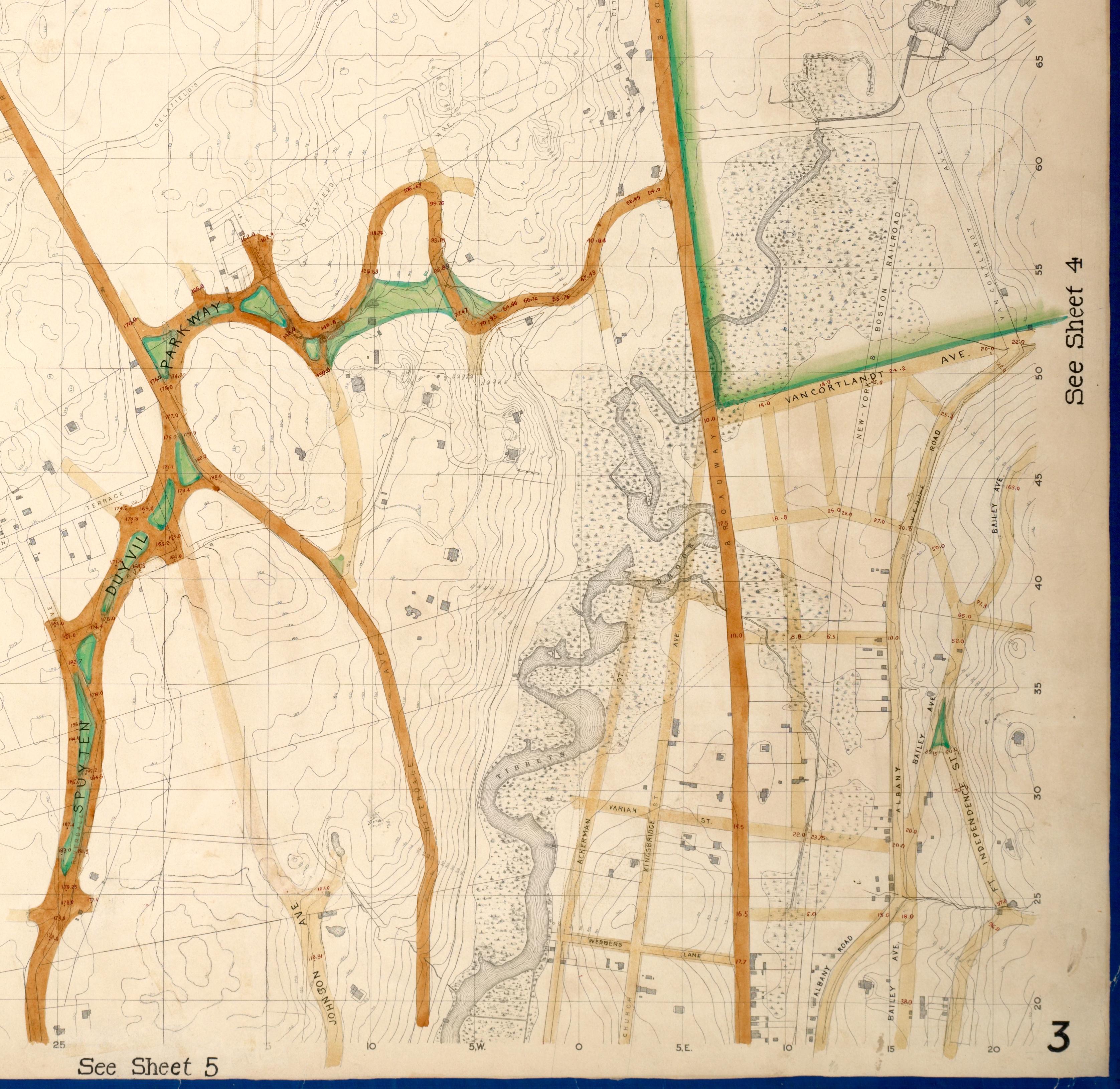
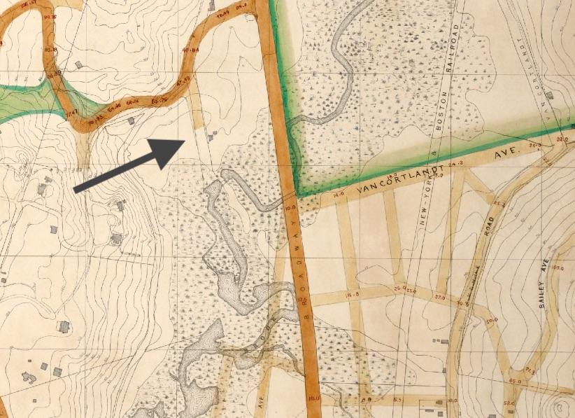
Hi folks, with regard to the image from 240th Street, I have a few more pieces of the puzzle to add. At least on historic maps from the 1870s onward, the roadway east of Broadway at 240th Street was never called 240th Street, but always Van Cortlandt Park South. That road was a “paper street” for a number of years before it was actually constructed, as were a number of other streets in this area. A very detailed 1873 topographic map showed that the marshlands surrounding Tibbetts Brook were substantial on the west side of Broadway where 240th Street would later be built, but fairly limited on the south side of Van Cortlandt Park South.
Here is a cropped version of the 1873 topographic map. https://digitalcollections.nypl.org/items/734f7d13-ed0c-9630-e040-e00a1806276f
In 1908, property east of Broadway and south of Van Cortlandt Park South was leased by the West Side Tennis Club and a new clubhouse and tennis courts were constructed there. In conjunction with a report I wrote last spring about the now shuttered Catholic school and church property at that same location, I found some wonderful images of the West Side Tennis Club’s property, beginning in 1908, at the New-York Historical Society and the Museum of the City of New York. I’ll post a few of them here. The West Side Tennis Club moved to Forest Hills, Queens, in 1913 and is still active today. They have a nice image of the old clubhouse on their website as well.
Here is the 1908 photograph of the tennis facility being built, from the New-York Historical Society. The view is looking southeast from Broadway. Although the citation suggests 1920, this is erroneous. Tennis club at Broadway and 240th Street, Bronx, undated (ca. 1920). | New York Historical Society | Digital Collections (nyhistory.org)
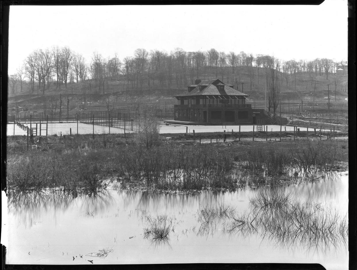
And here are a couple more photos, from the Museum of the City of New York. The first is the same view as above, but a few years later. The second view is looking north with Broadway on the left. Both of these are from ca. 1910.
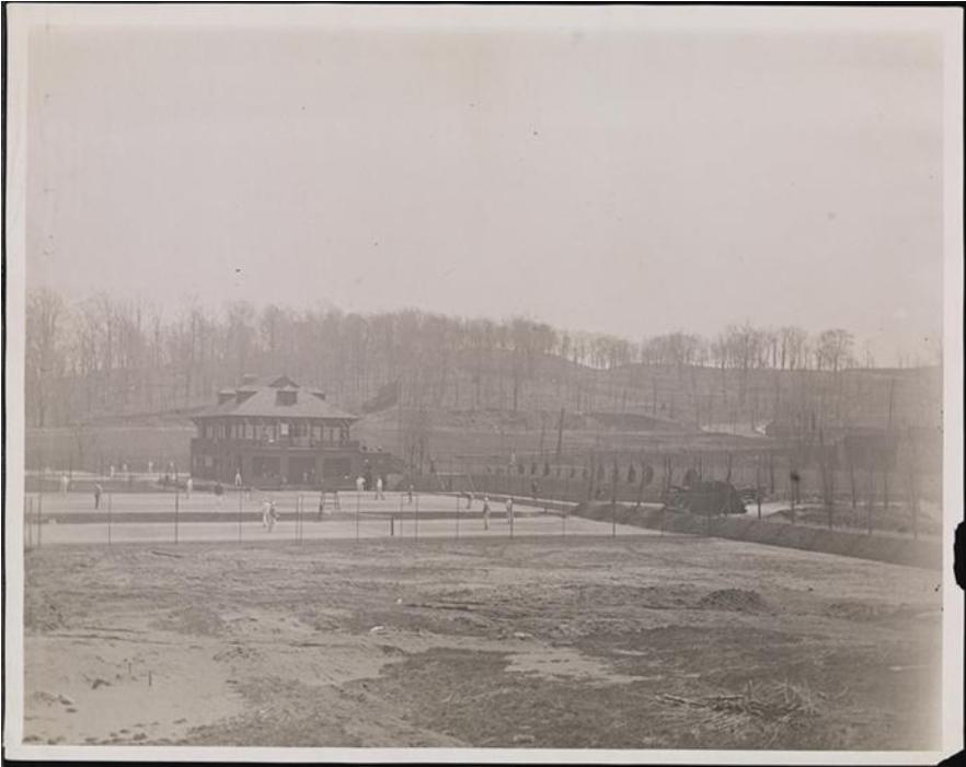
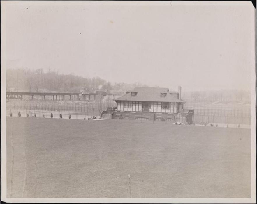
Based on these images and their dates, it seems more likely that the image from 240th Street is not looking east, but probably is looking west, as Nick first suggested. Thanks for the chance to revisit this very interesting area!
-
February 27, 2023 at 7:17 pm #3292
The preponderance of clues persuades me to agree that Nick’s interpretation is correct. The map shows that the eastern spur of West 240th street was known as Van Cortlandt Avenue and the photograph is noted as “Bway & 240nd st”. And, then of course, there is extensive marsh throughout the west side of Broadway, although one could make the claim that over the intervening years, the marsh on the east side could have crept south to what became Van Cortlandt Avenue. I am somewhat confused as to why Spuyten Duyvil Parkway is not shown as an established road under the brown tracing. Was it being proposed on this map?
The map also shows what I surmise is Irwin Avenue as a road going up the elevation (as Nick mentioned) and connecting to a road going easterly (down hill) and then toward the north, connecting to Old Post Road. That last portion is now known as the beginning of Manhattan College Pkwy. Where the brown tracing of SDPkwy connects with Broadway is shown a building that I believe is in the photograph of the IRT station.
Thank you for offering these clues! -
February 28, 2023 at 6:51 pm #3295
Thanks for sharing that great map, Julie. The tennis club you identified was the site of the 1911 Davis Cup tournament, a pretty big deal in the world of tennis.
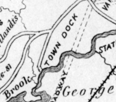
That area west of Broadway at W. 240th Street (about where Gaelic Park is today) was the location of the town dock. It is hard to believe at this point because there is no water in sight but the photo shows just how vast the marsh really was. The map you posted indicates a lane coming south from W. 242 toward Tibbetts Brook:
This 1909 property map depicts that road and labels it as “Free Landing Road.”
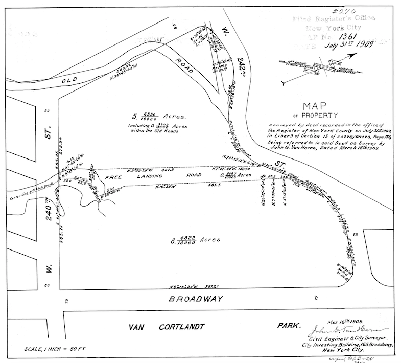
The term “landing” indicates the presence of a docking place for boats and Thomas Henry Edsall’s Historic Sketchmap of Kingsbridge labels it that way:
Colonial-period land deeds refer to it as the “Stony Brook Landing” as the little stream that fed into Tibbetts Brook from the hill to the west was known called Stony Brook. That stream still exists but it is fed into the sewer system at Brust Park across the street from Manhattan College.
-
March 1, 2023 at 9:29 am #3296
Wow, I should have figured that this group would have already known about the West Side Tennis Club and its history — clearly I am late to the party! I love the photos you linked to the 1911 Davis Cup tournament, which I had not seen before. And what a tale of transformation of the block containing Gaelic Park! I always learn something new here; thanks again for sharing.
-
March 1, 2023 at 3:26 pm #3298
It looks as though the Free Landing Road might have had one end meeting Spuyten Duyvil Pkwy at where 4568 Manhattan College Pkwy is located with its other end terminating at what is now Gaelic Park.
Julie, you are not as late as I am to this enjoyable party! I found this site through a facebook posting by Brian Andersson, who is a second cousin to my ex-wife (with whom I am still good friends). I’m so glad I signed up. Going through the various offerings has brought back childhood memories and a curiosity for discovering the history of Kingsbridge. -
August 23, 2025 at 2:23 pm #4965
I am looking at the photos and reading the text in August of 2025.
Thank you everyone for all this amazing information
-
-
AuthorPosts
- You must be logged in to reply to this topic.