Home › Forums › Native Americans › Local Munsee Placenames
Tagged: Munsee Placenames
- This topic has 20 replies, 3 voices, and was last updated 3 years, 6 months ago by
ndembowski.
-
AuthorPosts
-
-
December 12, 2022 at 5:58 pm #3085
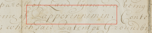
The Munsee people that lived in our area had their own names for places in the neighborhood. We know some of them from surviving land deeds and other documents from the colonial period. One of the best documented names is Paprinimen. The earliest record (that I’ve been able to find) of the name comes from a 1653 letter written by Adriaen van der Donck, the first Dutch colonist to live in today’s Northwest Bronx. He described his land as “stretching as far as Paprinemin called by our people, in spite of the dyvel.” To him, it seems, Paprinemin was a synonym for the Spuyten Duyvil Creek. In 1669 the mayor and aldermen of New York City ordered the Harlem ferry operated by Johannes Verveleen to relocate to “a Place called Spitting duyvell.” He was further ordered “to lay out a place upon that peece of Land called Papiriniman . . . for his habitation and accommodations of Travallers.” Here, Spuyten Duyvil seems to refer to the creek and Paprinimen to the land north of the creek.
One thing I find fascinating is that the name survived in the local parlance through the middle 1800s. Andrew Corsa, who served as a local guide to George Washington during the Revolution recalled as an elderly man in 1850 that “on the 3rd of July, 1781, the island of Paparinimo swarmed with red coats.” So, what was the “island of Paprinimen?” That refers to the central part of Kingsbridge stretching from W. 230th Street to about W. 238th Street. When the waters of the Harlem River swelled at high tide, it would flood the marshes down in Kingsbridge and completely surround it with water making it an island. The animation below shows the original course of Tibbetts Brook in blue and the location of the Kingsbridge marshes in green, which were flooded at high tide.
If only the name had continued in common usage for another 100 years, we could very well have been called the Paprinimen Historical Society!
In the 20th century, Native American artifacts were found on the land of the historic island of Paprinimen when the Kingsbridge post office was built at W. 230th Street and Broadway. At the time, local historians thought that it might have been the site of a Munsee settlement. A 1744 travel diary written by Dr. Alexander Hamilton, who was staying at the tavern on Paprinimen, confirms that that Munsee bands were indeed living in that area. Hamilton wrote that they “waded about stark naked and threw the oysters, as they picked them up with their hands, into baskets that hung upon their left shoulder.” The Munsee were fishing for oysters in the Spuyten Duyvil Creek, which produced great quantities of them.
[caption id="" align="aligncenter" width="1045"]
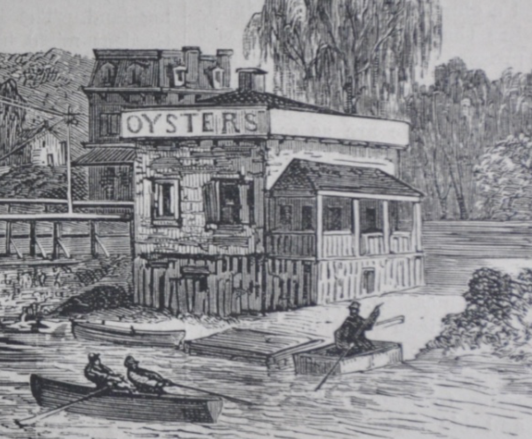 An oyster shack in Kingsbridge in 1873. It stood at the Bronx side of the King’s Bridge at today’s W. 230th Street and Kingsbridge Ave.[/caption]
 -
December 13, 2022 at 5:06 pm #3086
Another name that shows up multiple times in early colonial documents is Shorakappoch (and other similar spelling variants). This name was primarily used to refer to the Spuyten Duyvil Creek where it met the Hudson River. In the previous post I mentioned, Adriaen van der Donck, the first Dutch colonist who lived in the northwest Bronx with his wife Mary. After Van der Donck’s death, Mary remarried and the English governor confirmed that Adriaen van der Donck’s former lands would go to Mary van der Donck and her new husband in a patent dated October 8, 1666. The patent defined the property boundary as running southward along the Hudson River “to the kill [or stream] Shorakkappoch, and then to Paprinimen, which is the southermost bounds.” This patent set the southern boundary of Yonkers from 1666 to 1872 when Kingsbridge voted to become independent from Yonkers.
Both Manhattan and The Bronx have staked a claim to this ancient name for the Spuyten Duyvil Creek. In today’s neighborhood of Spuyten Duyvil, the name “Kappock Street” honors its Native American past.
[caption id="" align="aligncenter" width="443"]
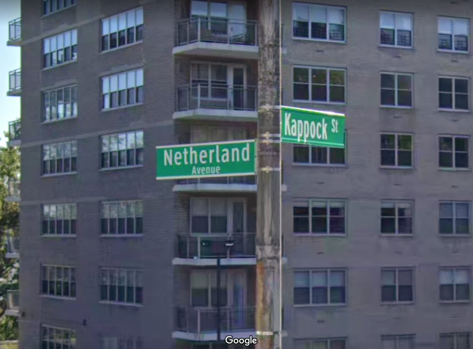 The intersection of Kappock and Netherland hints at our neighborhood’s early history.[/caption]
In Manhattan, Shorakkappoch rock in Inwood Hill Park displays the plaque below:
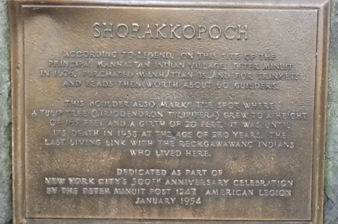
There is no evidence to suggest that Peter Minuit purchased Manhattan on the site but there is plenty of archaeological evidence showing that there was indeed an indigenous settlement in today’s Inwood Hill Park. Local historians have referred to that settlement as the village of Shorakappoch.
-
December 14, 2022 at 5:52 pm #3090
 According to History In Asphalt by John McNamara, Paparinemin meant “Place of False Starts”, alluding to the double tide caused by the Hudson and the Harlem Rivers.
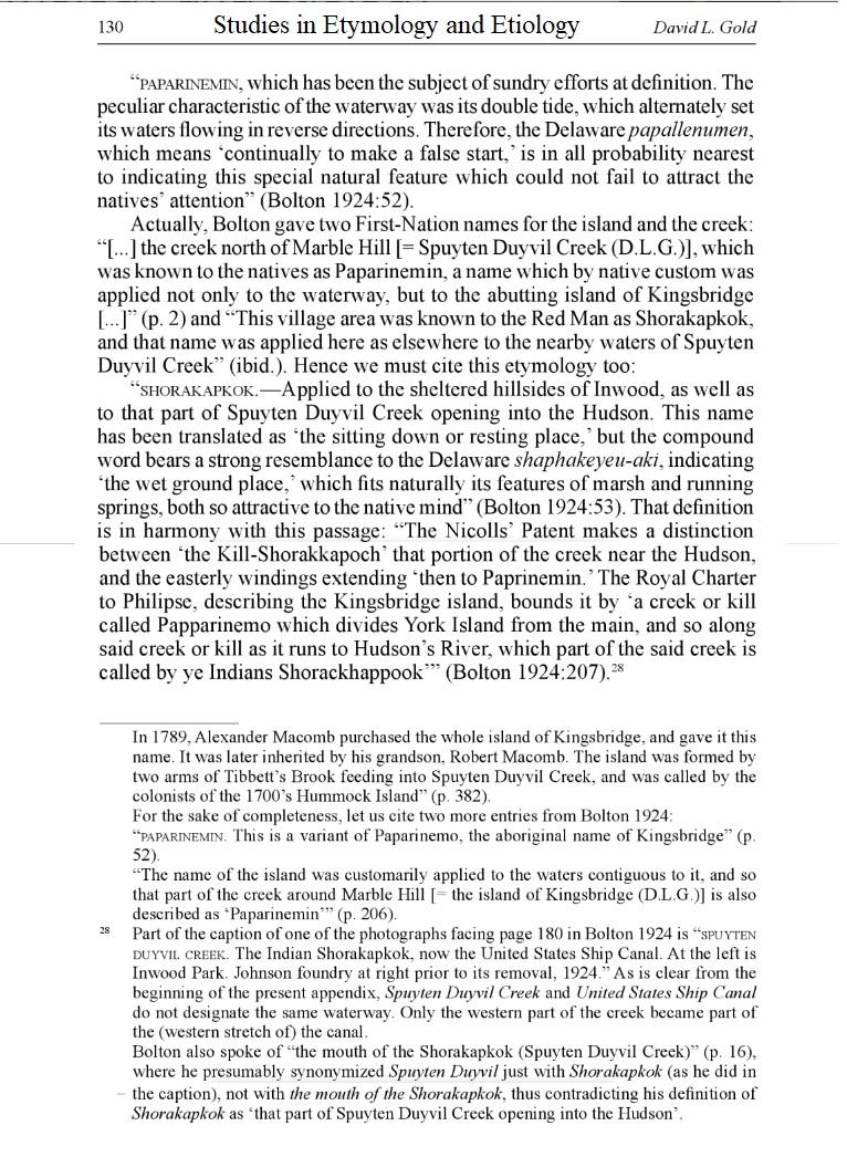
Also see- Studies in Etymology and Etiology, by David Gold ( attached) -
December 14, 2022 at 5:58 pm #3091
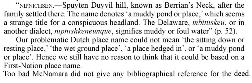
Lets not forget Nipnichsen
-
December 15, 2022 at 8:14 pm #3092
Thanks for those, Tom. Where is the 2nd clipping from? It seems to allude to doubt surrounding Nipnichsen’s historic connection to our area.
Nipnichsen would seem to be one of the few names that survived into the 20th Century on Spuyten Duyvil Hill. There was William Muschenheim’s “Nipnichsen Terrace” near the Henry Hudson monument. In The Story of The Bronx, Stephen Jenkins wrote that when Muschenheim built his house, “both Indian and Revolutionary relics were unearthed,” which may have had something to do with the name.
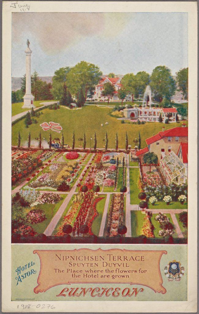
And there was the Nipnichsen Club, a social and tennis club that stood at W. 230th Street and Fairfield Ave
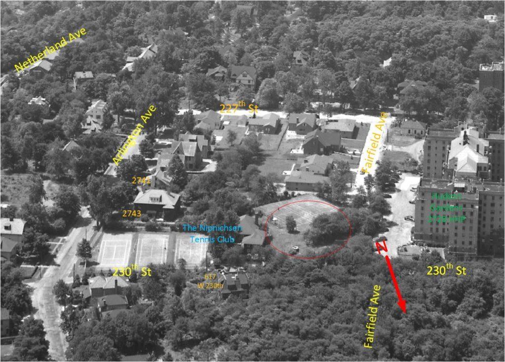 (photo labeled by Alan Lasky)
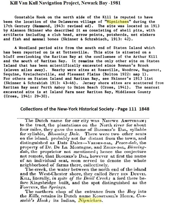
But more recent scholarship casts doubt on the old story that Henry Hudson’s Half Moon was attacked from a fort on Spuyten Duyvil known as “Nipnichsen.” In 1981, the Museum of the City of New York published Robert Grumet’s “Native American Place Names in New York City” and this is what he wrote about Nipnichsen:
A review of the location of the fort reported by [Henry Hudson’s first mate] in 1609 has, however, indicated that it was located along the west bank of the Hudson River near Hoboken rather than on the eastern shore . . . [A] 1644 document has firmly located Nip Nickson in East Jersey. This location . . . has not been accepted by other regional investigators who have clung to the Bronx County location. The colonial record, however, has made the Bayonne Peninsula location of Nip Nickson the only acceptable locale for this place name.
I would only echo this conclusion by saying that the word Nipnichsen does not appear in any colonial documents I have seen pertaining to this area. But it is still a fun part of local lore.
-
December 16, 2022 at 9:54 am #3093
Nick, the clip comes from Davis Gold’s book
-
December 16, 2022 at 10:06 am #3094
The author Davis Gold concludes that the meaning of Nipnichsen does not fit the description of our area, and so it must have been selected by someone other than Native Americans. He was comparing the appropriate usage of Shorakkappoch, Paprinimen, Gowahasuasing vs Nipnichsen
-
December 16, 2022 at 10:25 am #3095
I could only find Robert Bolton, Cornelius Winter Bolton · 1881 use of Nipnichsen in The History of the Several Towns, Manors, and Patents of the County of Westchester – 1881 when describing Berrian’s Neck.
-
December 16, 2022 at 10:28 am #3096
I could only find Robert Bolton, Cornelius Winter Bolton · 1881 use of Nipnichsen in The History of the Several Towns, Manors, and Patents of the County of Westchester – 1881 when describing Berrian’s Neck & A History of the County of Westchester, from Its First Settlement to the Present Time
by Robert Bolton – 1848Ads
-
December 16, 2022 at 10:56 am #3097
Page 111 of the 1848 book by the New York Historical Society describes the Spuyten Duyvil Creek in Kingsbridge. In the next line, the hill in Bay, into the Kills ( Staten Island) was called Nipnichsen by the Indians. This is probably where the name Nipnichsen and Kingsbridge was connected by Bolton.
-
December 18, 2022 at 12:11 pm #3098
That makes sense, Tom. Earlier you mentioned the name Gowahasuasing. I think that comes from the deed to Fordham Manor that was executed in 1669 between John Archer and local native people. Fordham Manor was the area south of Kingsbridge Heights along the Harlem River and the deed is a treasure of local place names. Check out how the boundaries of the land are described:
a certaine Tract of Upland & meadow ground upon ye maine, begining Westward from a certaine place by ye Indians comonly called Mascota so it goes to another place called by them Yowahamasing & from thence Round about ye Kill called Papiriniman & so to run into Harlem Ryver at ye Hook called Saperewack . . .
Muscota (or Muscoota, Muskata, Musceeto, etc) seems to have been more of a description than a name. It meant something close to “wetland” so you see it used to describe several different places in our region. In the Fordham deed, it describes the Tibbetts Brook estuary. Side note: I don’t think “Mosholu” was ever used to describe Tibbetts Brook and if you feel like taking a deep dive on that issue, you can read this. I have seen Saperewack associated with Marble Hill and Yowahamasing or Gowahasuasing as the peninsula that historically jutted out from Spuyten Duyvil Hill before it was obliterated for the Harlem River Ship Canal. The tricky thing about some of these terms is that they only appear in one document, which makes it hard to confirm their veracity.
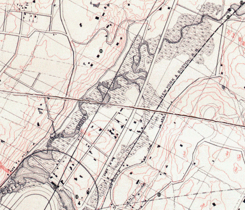
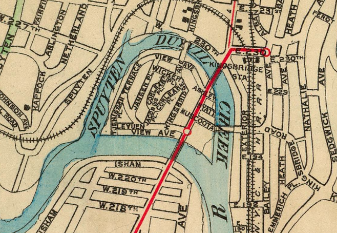
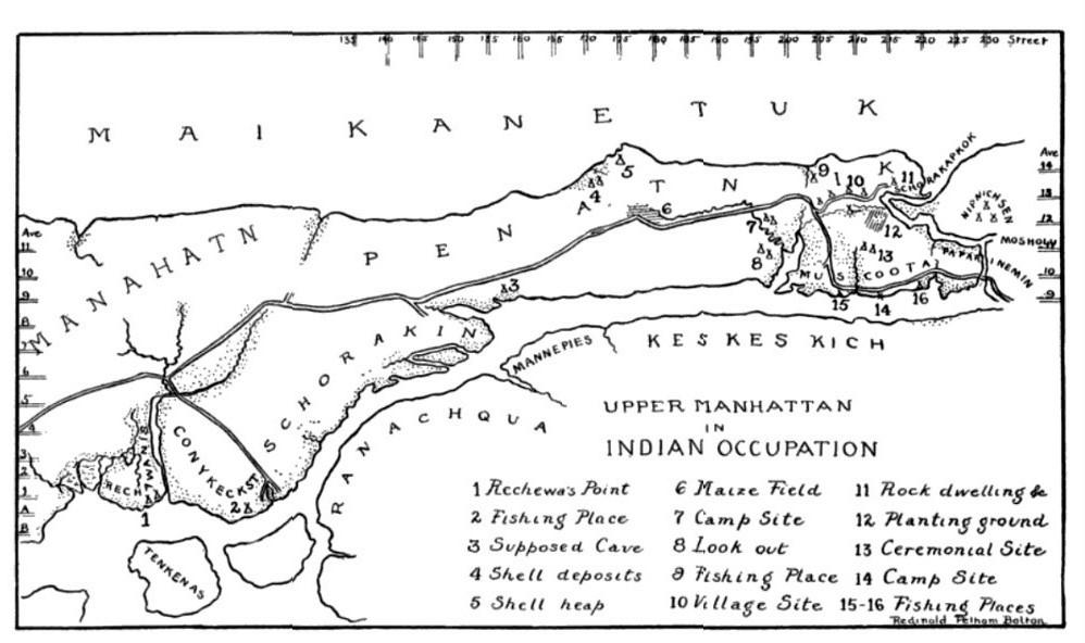
W. 225th Street, where it passes in front of Target, was once called Muscoota Street. You can see it labeled in this interesting map from 1900, which also shows the brief period when Marble Hill was an island.
-
December 22, 2022 at 7:30 pm #3131
Another local name seems to only appear in one colonial document: Keskeskich. I would feel more certain about the provenance of the word if it had been repeated elsewhere.
It comes from a 1639 land deed describing the sale of land from “Tequemeck, Rechgawac, Packamieus, owners of Kekeskich” to the Dutch West India Company. The land is described as:
a piece of land, located opposite to the flat on the island of Manhattan, called Keskeskich, stretching lengthwise along the flatlands, which runs behind the Island of Manhattan mostly east and west and beginning at the head of the said kil and running opposite of the high hill by the flatlands, namely by the Great Kil, with all rights titles etc.
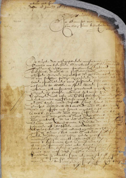
This is generally thought to describe at least the western part of The Bronx. It is interesting to think that the purchaser was a company. Photo of the deed:
-
December 22, 2022 at 10:43 pm #3132
Why is this thought to be Westchester County ? When I read Great Kil, I think of Staten Island or Jersey City
-
December 23, 2022 at 12:43 am #3133
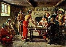
Kil is Dutch for steam or water so could be any location. Two of the native American chiefs referenced above were same who sold the name to Jonas Bronck. On April 22, 1642 a peace treaty was signed at Bronck’s homestead between Dutch authorities and the Wecquaesgeek sachems Ranaqua and Tackamuck. Jonas Bronck’s house was built by a promontory at the juncture of the Harlem River and the Bronx Kill across from Randalls Island this event is portrayed in a painting by the American artist John Ward Dunsmore.
-
December 23, 2022 at 1:28 am #3137
Peter, I just do not see the Bronx Kil as “GREAT”
Opposite the flat of Manhattan could be opposite Dyckman Flats ( Kingsbidge or University Heights) or Gracie Mansion ( Randalls Island ) or East Harlem ( Bronx or Randalls Island ) The only high hills could be in Kingsbridge and University heights…unless St Mary’s park is considered a high hill…( it was for me sledding ).. Then back to Bronck’s
-
December 23, 2022 at 11:06 am #3141
Hi Tom. I don’t think we can read these documents with any certainty in comparing to today locations. This is a very early old document 1639. It was in Dutch translated in English. Groot in Dutch means large, big and great. So large Bronx Kill could work. Perhaps to them 400 years ago it was a big river. During the Amer Rev the British tried to send a fleet up the Bronx River. It Didn’t fit. One of the keys between the document and what I commented was fact that 2 indian sachems were the same. Leads me to believe it wasn’t Staten Island or NJ but likely the Bronx area.
I don’t take all these early translated documents and Native place names too literally. Native Indians did not have a written language. Their names and place name were phonetically written by the person writing the document. Similarly to immigrant who had their names changed by customer agents. These are a good example of “you say tomato I say tomahto”.
-
December 23, 2022 at 11:31 am #3142
The Sachems point to the Bronx. I think the Harlem was the great Kil. (It’s a tidal strait ). Therefore, Kingsbridge is looking like the spot. Just wondering who received the property from the DUTCH WEST COMPANY
-
December 23, 2022 at 2:08 pm #3152
I would agree that the great kill could be the Harlem River. But I also feel it could be very likely describing the south Bronx across from Manhattan. It states land runs East to West ( across the Bronx) opposite the flat of Manhattan (Harlem) at the head of the Kil (East River across bottom of the Bronx) across from high hill (middle Harlem and north/Hamilton Heights/above old Polo Grounds etc) by the flats. Again this was description of 1639.
The land was bought by the West India Company for future use. Likely the same land that the sachems who signed the contract with Jonas Bronck. You see a lot of land sales being bought and sold over and over with each new purchases.
Here is the translation, there is a hot link above see above – 1639 land deed
This day, date as below, appeared before me Cornells van Tienhoven, Secretary in New Netherland, Tequemeck, Rechgawac, Packamieus, owners of Kekeskich, who in the presence of the undersigned witnesses voluntarily and deliberately declare, that in consideration of a certain lot of merchandise, which they acknowledge to have received and accepted before the passing of this act, they have transferred, ceded, conveyed and made over as a true and lawful freehold, as they herewith transfer, cede, convey and make over to and for the benefit of the General Chartered West India Company a piece of land, located opposite to the flat on the island of Manhattan, called Keskeskich, stretching lengthwise along the flatlands, which runs behind the Island of Manhattan mostly east and west and beginning at the head of the said kil and running opposite of the high hill by the flatlands, namely by the Great Kil, with all rights titles etc.
Done at Fort Amsterdam, the 3 August 1639.
Cornelis van der Hoyten
Davidt Pietersen de Vries
Cornells van Tienhoven -
December 24, 2022 at 12:02 pm #3159
We just went back & forth with our 2022 interpretations of the 1639 land deed. We did what the historians of 1906 agreed. They made a map and labeled it. However, Nick Dembowski threw a new wrinkle into the mix. The Long Island Sound has been called the Great Kill ! To me…now that is what I would call a great Kill, greater than Staten Island or the Bronx Kill. It would therefore make the the entirety of the Bronx “Keskeskich” East to West from the great Kill. By 1659 there was already a village established in the area called OOSTDORP by the Dutch that we know today as Westchester Square in the Bronx. On the Kill ( Westchester Creek ) referenced often in
 1659 https://www.google.com/books/edition/The_Documentary_History_of_the_State_of/KtuBzUJ6AzUC?hl=en&gbpv=1&dq=oostdorp&pg=PA557&printsec=frontcover
 -
December 24, 2022 at 12:36 pm #3160
In 1642, John Throckmorton was granted a patent from New Netherland in area named Vriedelandt or Vreeland / Oostdorp. So it would appear that the Dutch considered their holdings from the deed to include the Bronx. The Dutch claimed to own property east to the Connecticut River and the English claimed west to the Hudson. So they agreed to a boundary ( Black Dog Brook ) northeast of Westchester Creek, separating Westchester from Eastchester. Vreeland Ave located close to Westchester Square in the Bronx.
-
December 29, 2022 at 2:58 pm #3206
Regardless of whether the terms Mosholu or Keskeskick were ever used to describe the Native American settlement in modern Van Cortlandt Park, it was certainly one of the larger settlements in our area.
I just posted an article from 1890 about the excavation of a Native American village site on the Van Cortlandt Parade Ground. The amateur archeologist that explored the site, J.B. James of Riverdale, uncovered human remains and artifacts that are now in the collections of the American Museum of Natural History and the Smithsonian.
The transcribed and annotated article is available here.
-
-
AuthorPosts
- You must be logged in to reply to this topic.