Forum Replies Created
-
AuthorPosts
-
I enjoyed seeing the Pool and Rink photo didn’t know there was once one there. Today there is a NYC Parks swimming pool just across the street. There were originally two NYC pools, a swimming and diving pool. But a few years after being build the diving pool cracked. Another NYC Parks designed project. It was built over the submerged Tibbetts Brook and built on marsh lands and not well designed hence it being abandoned in just a few years.
Today swimmers at the V.C. pool can only wear WHITE t-shirts. Because there is a concern some children might wear Red or Blue colored T-Shirt that might be interpreted as a gang color. I can’t imagine that being a problem when the old Pool and Rink were active.
Johnathan its funny you should mention eating in the restaurant in the 70s. I did too with my wife. I can’t remember the name of the restaurant but believe it was the original Mosholu Hotel building. An old private wooden house. About all I remember is the dining room was dimly lit and the wall paper was red velvet with a paisley like pattern. Looked like a bordello from the 1890s in a western movie. Don’t remember the food but believe it was a steak house.
The Johnson-Berrian house was situated where today’s park house is located. It was facing south looking over the Harlem River into Inwood and Manhattan and with a sweeping view of the Hudson River at the right and New Jersey palisades. The only remanent of the house is an oak gavel that the KHS owns. I post a photo of the gavel in the forum while ago. If I find a copy I will post it here.
Regarding tree about the house. During the American Revolution just about all trees on Inwood hill and Spuyten Duyvil hill were cut down. This was done for two reason, fire wood and lines of sight so each fort could see each other and view troop movements. The house being pre-Revolutionary its surroundings were denuded of all trees.
Hi Tom – the apple tree in on the east side off Lower Independence Ave. Its just below the front door.
All the trees both big and small were removed from the back and south side of the church to protect the roof.
April 18, 2025 at 6:34 pm in reply to: James Walter Douglas, Spuyten Duyvil Industrialist, and local Philanthropist #4720The Raoul Wallenberg plaque is interesting to what it does not state. The person who made this park possible after facing a few years of push back by the then elected officials was Tom Bird. Tom is a neighborhood and long time resident and member of the KHS and one of the last members of the Edgehill Church community. Years ago Tom was a very active community activist. If it wasn’t for his tenacity and not taking NO for an answer, there would be no Raoul Wallenberg park. At the time, 35 years ago, our elected officials were doing a John Kerry being for the park before they were against it and in this case back for it. This was during the Ed Koch administration when the” City was for Sale”. But Tom keep pushing with save the park committee meetings and finally an Arms Around the Park rally that brought the community together to save the park. When the day came for the ceremony to dedicate the Park a flatbed truck was parked in the middle of Seton Park and was filled to the brim with our elected officials, community board members and many others. The only person not on the stage was Tom Bird. And so it goes, Thanks Tom !
September 10, 2024 at 4:07 pm in reply to: Beautiful Riverdale “Victorian Home” To Be Torn Down–How old is it? #4391For those of you who have been following this KHS Forum blog Nick Dembowski, President of the KHS, has done an amazing job researching and documenting this mansion which the paid archeologist and researchers missed. It is likely that this pre-revolutionary house is the oldest house (modified over the years) left in Riverdale. Over the years Riverdale has lost many great old historic houses starting in the 1950s with Robert Moses tearing down the Berrien-Johnson Pre-Revolutionary house in Spuyten Duyvil, Schiever Home & Hospital tearing down the 1840 Hudson River bracketed Peter Strang home in Spuyten Duyvil and the recent destruction of the foundation the American Revolutionary Fort No #2/ Fort Swartwout again in Spuyten Duyvil. Our history is quickly disappearing.
The C.B. 8 meeting is a zoom call so easy to access without leaving your home to attend. Attendance, even by zoon is important. A large number of attendees will show the community, Community Board 8 and Hebrew Home that the community does care about its past. Hebrew Home for the past few years since they bought the property never said they would tear down and destroy this house. Yet just recently it was quietly stated they would take down and destroy the house. It’s still rather interesting how the Hebrew Home was allowed to propose and get approval to build large apartment buildings for their new planned River Edge. How was it allowed to bypass NYC Zoning laws, SNADS and the Greenbelt laws? There has never been a clear statement, in writing, why approval to allow building of River Edge despite all the zoning and building restrictions. But money talks and so it goes.
So please click the link below and join the zoom call to hear about the house and the comments and questions from the community and CB8. It would be helpful but not required to read the initial report at top of this blog for background. PLEASE turn out for this meeting.
Join Zoom Meeting: https://us02web.zoom.us/j/2114033690
Join Zoom Meeting by Phone: +16465588656 Meeting ID: 2114033690#
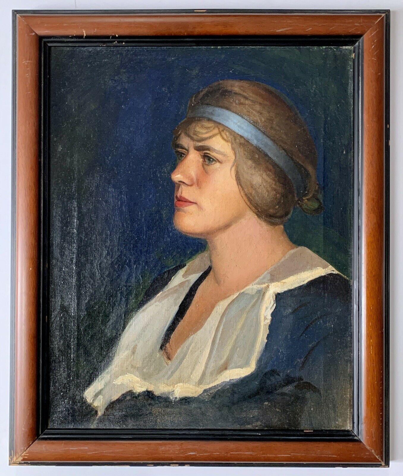
August 28, 2024 at 9:28 pm in reply to: How Was Fieldston Names? When Was Riverdale Born? – Here Are Some Answers #4359TO put a face to the name, Charlotte Livingston(1898-1991) and a painting she did of Giles Place in 1919. Her portrait was painted about 1935 by Francis Vanderveer Kughler her future husband. Charlotte lived most of her life in a private home on Kingsbridge Terrace. She was also a long time trustee of the KHS and her husband was a member.
231st and Palisades yesterday, will look again down scenic pl at another day for the house your looking for.

They must have liked the pandemic 8:0
I have always believed it was painted by Charlotte Livingston ( B 1898) who also was a long time trustee of KHS. She lived her life in Kingsbridge and married to Francis vander veer Kughler who was a professional artist.
It looks to me as if the women in yellow dress running down to greet the man in brown suit with grey hat. It is the early 20th C. painting. Today she would likely be chasing someone who just stole her bag.
The car could date the painting if someone can put a date as to the style.
Most of the people look to be wearing face masks which would fit for the flu pandemic. 1918-1919 but the car is not of that period.
Peter Tarantino was born in 1853. Not Peter Ostrander 8:)
The word in my reply should have read abbattis not atlantis, !@#$%& auto correct
The Sage mansion later Edgehill Inn was located on Netherland Ave below 230th st on the East side of the street.. The site of Fort # 3 during the Amer Rev and connected by an
Atlantisabbattis that ran to Fort #2. If you in the area you can see where it was located by homes that were built on the site as they are set in from the street and homes on that side. In older photos of the Kings Bridge showing todays Ewen park hill and Spuyten Duyvil hill there is a large house that dominates the hill.I knew about the Brooks Collegiate name on building but didn’t realize what it was, thanks.
The site in question is also an old and historic location of the pre-Revolutionary Free bridge or Farmers bridge. The Kings Bridge at that time was a toll bridge. The Kingsbridge Historical society placed a bronze plaque on the Brooks Collegiate building in 1959 to celebrate the anniversary of the Free bridge having been build in 1759. Unfortunately, in the years when the “Bronx was burning” the plaque was stolen and likely melted down for its value.
Here is a write up on the plaque from William Tieck’s book on Riverdale, Kingsbridge and Spuyten Duyvil.

I had been told number of years ago by someone who lived in the building that FDR had visited Flynn at his penthouse in Hudson Gardens.
Here are a few photos taken from one of the present penthouses about 30 years ago. The empty lot behind the building was the site of the American Revolutionary Fort #2 or Fort Swartwout. About 10 years ago the KHS in conjunction with Fordham U. tried to do a archeological dig prior to building new homes but were not successful. The rather arrogant or perhaps ignorant landowner and builder would not allow a dig and since have built rather unimpressive homes that sold for 2-3 million dollars each. But surprisingly most of the fort site is still present west of the last home built.


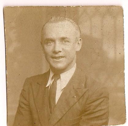
In the vein of putting a name to a face, in this case a face to a name.
In the above newspaper clippings from 1918/1919 there is mention of a George Endlich who was manager and team captain of the Anoka semipro baseball team out of Yorkville.
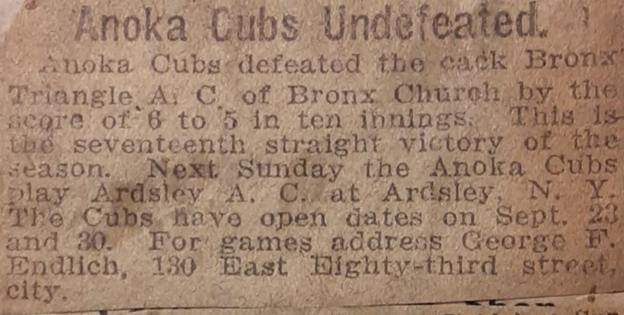
Here is that George F .Endlich, who also was my grandfather.
 March 5, 2024 at 7:06 pm in reply to: The Russian Mission under construction, from the top down, 50 years ago #3967
The FBI also had offices to watch and listen in on transmission at the Russian building from an apartment on ground floor of 5200 Fieldston Rd across from the Russian mission. They also owned a private house across the street right next to the Russian Mission. This private house was knocked down 8-10 years ago after being purchased by a Jewish temple as the site for a new temple. Nothing has ever been built on this site.
Have to wonder who is listening or monitoring the Russian mission these days.
March 4, 2024 at 1:23 pm in reply to: The Russian Mission under construction, from the top down, 50 years ago #3963Interesting is the fact that they build their building like they run their country, from the top down.
Years ago there were articles that the building was in poor shape, and they wanted to take it down and rebuild it and few other buildings in its place but believe it was not approved by NYC.
It should also be remembered that it was built for the USSR – the United Soviet Socialist Republic that consisted of 14 countries when the USSR fell apart at end of Dec. 1991 it now only contains Russia. The building holds diplomats (and spies) that support the U.N. Every day you will see large, unmarked buses leave in the morning and return at night. The countries which made up the USSR were: Armenia, Azerbaijan, Belarus, Estonia, Georgia, Kazakhstan, Kyrgyzstan,Latvia , Lithuania, Moldova, Russia, Tajikistan, Turkmenistan , Ukraine (which Russia is trying to get back today!) and Uzbekistan.
I like to kid that you can still notice these other former USSR country staff still in Riverdale as the women are the ones wearing winter boots in the warm weather and you can tell our Russian ‘comrades’ from the Mission building by their dour unsmiling faces. Seeing what just happened to Navalny you know why they don’t smile.
From news video reports the fire seemed to have started or was the largest in the corner deli , Cold Cut City at the SE Corner of Kingsbridge Ave and 231st St. For those who remember it was the location of a great German bar and restaurant, Ehrings Tavern. News reports state that 6 business were lost during the fire. Touch time especially during the holiday season.
The yellow building in the Lawson painting I believe was located on the SE corner of 231st St and Riverdale ave across from the Ewen park steps. It was for years was an animal hospital and was recently torn down and is now another NYC lower school. Lawson’s perspective is similar to when you use a small F stop when using a focus camera. The perspective is compressed. So, in the painting the yellow building looks much closer to the Dutch style building located at 23oth street west side. The photo I’ve attached shows the yellow building at the lower left corner with photo looking north east over today’s Ewen Park, photo dates from 1915.
There are two stone pillars on Palisades Ave just north of W 232nd St. Basically, just west of the JR Whiting estate discussed. Back in the 1960s to 70s believe may have been used as entrance to the U Thant estate. But good possibility they were once another entrance to the JR Whiting estate .
I grew up on Webb Ave by OLA in Kingsbridge Heights. When I was very young my mother and grandmother would bring me shopping down in Kingsbridge with my brother. We had no choice. The walk down was too bad but the street steps back up with packages was a hike. We hit Buster Browns for shoes on Broadway usually at the start of school. But their major shopping all year long was at Fuhrmann’s Department store, They loved that store, as a kid I hated it. The Woolworth’s toy dept was more to my liking. The main shoppers in Fuhrmann’s were older women buying house dresses, dishes, kitchenware, cloths and everything in between.
It was located on 231st St across from the Dale movie theatre and Dime saving bank, between Broadway and the Deegan, The original family store started in 1910 and later built this larger 2 floor building. After it closed for business, it was replaced by a John’s Bargain store. There was a central staircase to the lower lever in Fuhrmann’s. It was very long, wide and steep. I am surprised some older shopper never took a header down the stairs. I realized many years later why the lower lever was so deep. Back in the late 1890s they filled in the tidal swamp along Broadway created by Tibbett’s Brook meeting the Harlen River at high tide. The basement was at the level of the this filled in creek, hence it’s depth. Actually, it was the same reason if you ever were in the RKO Marble Hill movie theatre and had to use the bathrooms. It was a rather scary walk down a very steep staircase especially during a horror movie. But not as scary as the old matron in the white lab coat who kept watch over all the kids in the audience. But no I never threw a flattened popcorn box like a discus, wasn’t me, as she shined her flash light my way.
I’ve attached a link to a YouTube made decades ago by the grandchildren of the Fuhrmann’s family. For those of you who remember the store it will bring back memories. For those not familiar with the store I think you will enjoy as its well done and really captures the essence of what the store was like back in the 50’s, 60’s and 70’s.
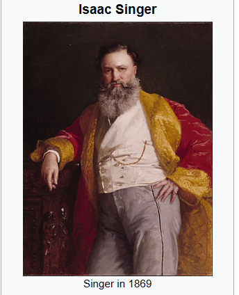
It was a major accomplishment to have invented the bestselling sewing machine in the world. But I have to be honest that his earlier life is very interesting. “Isaac Merritt Singer was born in Pittstown, New York, on October 27, 1811, and raised in the upstate town of Oswego. At 12, he left home with minimal education and started working a string of odd jobs as an unskilled laborer. As a teen, Singer took on a promising apprenticeship as a mechanic, but his interest in acting soon spurred him to abandon the job and form a traveling theater troupe instead. While on a national tour with the Merritt Players, Singer frequently engaged in promiscuous behavior, resulting in the birth of some dozen and a half illegitimate children. After nine years on tour, Singer went broke and the group was forced to disband.”
Singer died in 1875, dividing his $13 million fortune unequally among 20 of his living children by his wives and various mistresses, although one son, who had supported his mother in her divorce case against Singer, received only $500.
In today’s dollars Singer’s $13 Million would be worth about $355 Million.
I don’t think I can look at a Singer sewing machine again without thinking of Isaac.
Singer was very wealthy by the time he moved back to the States with his new young bride and to Kingsbridge. But what doesn’t fit is the location of the name Singer on the map with Isaac Merritt Singer. The Town & Country article states his home as “large, comfortable wooden building atop a high knoll they were able to see the magnificent panorama of the Hudson to the West and Harlem and East Rivers to the east” while the name on the map indicates a location in the Kingsbridge Valley with little to no view. P.S. 7 is located on Kingsbridge Ave. Another article on the net states he built a large home called The Castle in Yonkers. The Bronx was at his time part of Yonkers so his house must have been up on the Riverdale ridge or further north into today’s Yonkers.
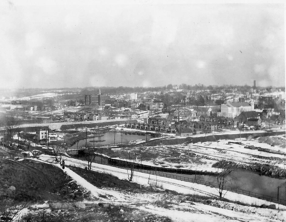
I would agree with that as the Jerome Pk Reservoir was built between 1894 and 1905 the same time period as the photo’s posted at top. The dirt removed when Grand Central Terminal was built (ca.1912) was used to fill the Spuyten Duyvil creek initially east of the original Kings Bridge. That is from today’s Kingsbridge Ave and 230th St eastward.
-
AuthorPosts