Forum Replies Created
-
AuthorPosts
-
September 4, 2024 at 8:12 am in reply to: Beautiful Riverdale “Victorian Home” To Be Torn Down–How old is it? #4386
That is a beautiful building with so many unique design elements. It would be a shame for it to disappear, especially given that it began its core existence in the pre-Revolutionary period. A lack of sufficient care or interest in preserving our history (and the anticipation of monetary gain) resulted in the burial of the Kings Bridge at W. 230th Street and the loss of the Godwin and Moller houses. It appears that more of the same will happen to the Victorian Home.
August 31, 2024 at 10:19 pm in reply to: Beautiful Riverdale “Victorian Home” To Be Torn Down–How old is it? #4373In viewing Google Street View the utility building vanished between 2021 and 2022.
August 29, 2024 at 8:50 am in reply to: Beautiful Riverdale “Victorian Home” To Be Torn Down–How old is it? #4361Thank you for this, Nick. I would think that based upon your analysis of the history of the house that it deserves landmark status. Is there some way for this to happen and for the house to be saved?
The Sanborn Maps wikipedia page explains how the maps were kept up to date. It was very labor-intensive, sending out a cadre of people to physically paste new information on each map held by subscriber businesses. Wow!
Thanks for that additional info on the insurance maps, Tom. I would assume that any map shown on the publisher’s website would be considered the latest and greatest. But, how were things handled back in the early years of the 20th century?
I have an unknown Manhattan student to thank for saving my life back in 1943(ish). In the middle of summer on a very hot day I had grabbed an ice cube from the refrigerator and was sucking on it as I walked up Spuyten Duyvil Pkwy. Class had just let out and students were walking down to the subway. The ice cube got caught in my throat and I couldn’t breath. I suppose that I was clutching my throat when one of the students bent down, grabbed my ankles, swung me upside down and hit me on the back. The ice cube popped out and I was put back on my feet. The student continued to walk away as I recovered. Luckily, I was a small, lightweight kid and he was a strong and quick-thinking person. I guess engineers are kind of bright individuals 8^D
Thanks for the clarification, Tom. In my field of endeavor I was always aware of the need to highlight any revision to documentation. Without revision letters, I wonder how those maps were not a cause of confusion, unless those revised maps were somehow identified.
Testtesttest, I was aware of the footpath. One of my friends who lived at 3875 Waldo Ave would use the path to get to Broadway and a meat market in that area. I wonder if it ever had become a road, though that seems very unlikely.
Nick, your link to the original photograph of “Hedley Hall” states that it was taken from W 242nd street circa 1916. I’m thrilled that my guesses were so close!
The description of the photo says that the field was “Interborough Field”. Was the land extending from the 240th Street Yard to W 242nd street owned by the Interborough Rapid Transit company (IRT)?
In the 1901 map there appears a road labeled “Road”. Do you think that that may have been Irwin Avenue? Did it actually connect with the intersection of Waldo Ave and Spuyten Duyvil Pkwy?
I can’t seem to paste a picture of the Street View of the intersection of Waldo and Manhattan College Pkwy looking down what may have been Irwin Ave (with boulders to the left of the path). Many years ago there was a stone retaining wall just to the left of the sidewalk that extended from the intersection to past the front of the red building with the glass façade (Kelly Student Commons). There was a drop off to its left, on what I think was the Irwin Ave side. My recollection from 1942-1943 is that there was no road there.
Tom, the map from 1901 shows the IRT train tracks and 242nd Street station as well as the 240th Street Yard. From what I can find the Yard first opened in 1906 with the barn finished in 1911 and the train station opened in 1908. Do you think that the planning of those was completed sufficiently before to be included in the 1901 map? Or could there be some other explanation?
Yes, Nick, that factory made various chocolates. The aroma was mouth watering at times. I’m not sure why the decision was made to sell to Manhattan College.
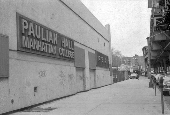
The Paulian building probably was razed and replaced by the parking garage, though I have no information on that.
According to manhattan.edu, Manhattan College purchased the building in 1957 and opened it in 1958 as Paulian Hall. They sold the building in 1966.
I remember peering in when walking by and seeing skaters. I also somehow got into the pool in the back when it was closed and empty of water and wondering about the gymnastic rings hanging by ropes. Luckily, they were too high for me to reach or I probably would have climbed on them. Falling off of them onto the concrete floor would not have been pleasant. This occurred before 1957, possibly in the mid to late 1940’s.
I lived up the block (W 242nd street) at 4652 Manhattan College Pkwy. I remember the owner/manager of the Gulf station whose name was Hans who also had an old German shepherd dog. I used to fill my bicycle tires with air from the air pump stand (free in those days 8^). Sometimes the dog would wander up to me to say hello. Across the street from the gas station, on the curve toward the entrance to the train station, was a French Bake Shop. My mother had a part-time job behind the counter in 1938-1940. As a teen I would wet mop the floors after school (c.1951).
The building is now a parking garage. There is an entrance to it on Manhattan College Pkwy with a pedestrian walkway from the College to it. I’m not sure if there is any affiliation between the two, or if it is just a convenience for students and faculty who might park in that garage.
As I see no evidence of 4568 Manhattan College Pkwy in the background, so I would say the picture was taken some years before 1925, the construction year of that apartment building. I don’t see Manhattan College (MC) either, so the picture was taken before 1922, the year MC cornerstone was laid. The 240th Street Yard (the train barn) was completed in 1911. I would say that the picture was taken between 1911 or 1912 and 1922 or before. I’m going to put a number on it and say that it was taken in 1915 (for want of anything more concrete).
On the corner of W 242nd Street and Broadway there used to be a Gulf gas station and repair shop. I think that the photographer took the photo from close to that corner, before any development of that land took place.
Soon after that photo was taken that land had an outdoor swimming pool constructed in left field as well as, in center and right field, a building along Broadway that housed a Pontiac dealership as well as the pool business and skating rink. I believe that in the 1950’s the pool was filled in and the building was taken over by Manhattan College and repurposed as Paulian Hall.
Here is a picture (credit: manhattan.edu) of the building showing the Gulf gas station at w 242nd Street in the background:
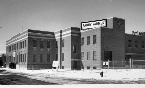
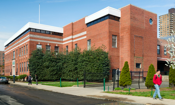
In 1949 Fanny Farmer built a factory near the corner of Corlear Ave and W240th Street that was purchased by Manhattan College (MC). It was in that building that MC housed a nuclear reactor in 1963.
Here are before and after pictures (credit: manhattan.edu) of the building:
Fun fact: I used to see Sugar Ray Robinson driving in his pink Cadillac convertible on W 240th Street. I assume that he had been visiting his mother whose house was on Corlear Ave.
Autocorrect??? LOL
Anne, did you mean to type 2465 Palisade? 2475 seems to be too far to the left of the station and the Villa Rosa Bonheur.
I agree. I have a friend who paints in this style.
Bstein, are you speaking of the Esmeralda property?
Tom, I think that your picture shows the near-completion of the townhouses. Google street view photo dated September, 2021 shows the same building, without scaffolding.
Checking Google Maps Street View, the earliest picture was taken in September, 2007. That picture shows that the original house(s) was razed and construction had begun, if, indeed, the property had been built upon. Judging from the weathered look of the board barrier, they might have been up at least a year. NYCityMap webpage lists the construction year as 2008 for those houses. The house to the rear of Esmerelda facing Independence Ave was constructed in 1920, again, according to NYCityMap webpage.
Yes, that is what I meant by “or that the lot not be subdivided”. Apparently, no restriction to subdividing is in the covenant. Too bad.
There is a building in the upper left section of the painting with a man coming down the stairs. It appears that the apartment building (2465 Palisade Ave) is in that location today and was build in 1958. Does anyone have information concerning the old building?
The car might be a mid to late ‘20’s Hupmobile…or not. Fedora hats became popular in the mid ‘20’s as did just below the knee dresses and coats for women. The Villa Rosa Bonheur house was constructed in 1924. I’d say the painting possibly dates to that time. I don’t see facemasks.
I assume that the covenant does not restrict multiple single family homes on the lot or that the lot not be subdivided. A shame that this beautiful house will possibly be razed. Plumbing and electrical service can be potential problems in an old house, but still…such beauty just is not duplicated in modern construction, imho.
The domed building, of course, was P.S. 24.
Tom, could you double-check your photo. I can’t seem to match it to what is shown in Google Earth and Google Maps – Street View of 4645 Delafield Ave. (though it is, in itself, a beautiful home).
In the early 1950’s, during our nocturnal wanderings in the neighborhood, we would sometimes stop at Ah Ping to eat an egg roll to assuage our nighttime teenage hunger. Who knows, Tommy Hsu might have taken my order! (although I doubt it, lol).
-
AuthorPosts