Forum Replies Created
-
AuthorPosts
-
tmara2, that is a great find! I see that the wooden building I referenced is no longer there behind the Gulf station. Looking at NYCMap the development of that corner where the wooden building was, occurred in 1931, so my picture must have been taken a little time before 1931.
Peter, was the diving pool located just north of the existing pool? Google Earth seems to show a filled in square area. I can say with certainty that during the 1940s and up to 1955 there were no gangs in the area. It’s a shame that concern over gangs are with us today.
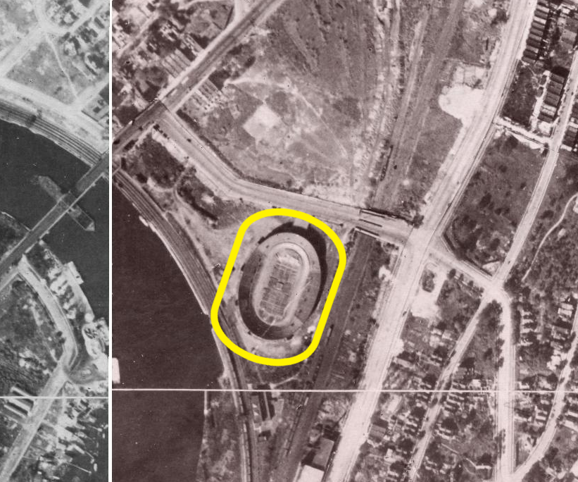
Thank you, Tom. I can see that the shape lends itself to bicycle racing as opposed to a baseball field. I’m sorry for the misdirection. Was it built on the same site as the aborted new Hilltop Park stadium?
With regard to the Hilltop Park stadium, I believe that I located the new stadium that was being built at 221st street and Kingsbridge Road. According to the article, the construction was not completed, but some structure (yellow oval) is evident in the 1924 aerial photo below (from the NYC Then & Now app).
In regard to The Hoboken Turtle Club, judging from the description of how the members ate (gorged), it wouldn’t surprise me that the majority of the men didn’t last into their 60’s before dying of either cirrohosis of the liver or arteriosclerosis, or both. Wow, what appetites! (Too bad about the turtles 8^(
If the purported history of the Kingsbridge Hotel is correct, what a shame that such history was ignored and disregarded. Is there even a plaque to commemorate the site? Probably not.
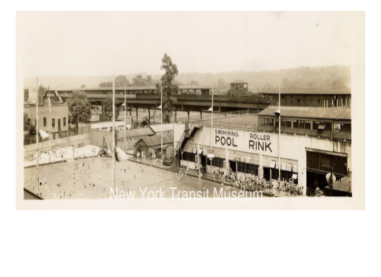
https://nytransitmuseum.catalogaccess.com/photos?search=&page=475&size=50&withImages=falseScroll
Scroll down to “Swimming Pool”
I was scanning through the N.Y. Transit Museum looking for photos of W242nd Street and came across this photo of the swimming pool and skating rink that I mentioned in my post #4308 above. The pool and rink supplanted the baseball field. The photo was probably taken from the catwalk that went from elevated train tracks to the repair barn. The photo is undated.
The low white building that is behind the pool’s vertical light posts may be the Gulf gas station (or not) and beyond that building is the wooden building that was just south of the carousel, both shown in the aerial photo in post #4957.March 23, 2026 at 4:01 pm in reply to: Fuhrman’s Dry Goods – The History of a Neighborhood Store #5182I can’t count the number of times I looked at my Xrayed feet on the green screen as a child. I’m surprised that I haven’t grown a second head or had deformed children. I guess that the unit was shielded well…hopefully. I also vaguely remember turning in a used toothpaste tube at Fuhrmans (lead material If I remember correctly…UGH) during WWII…scrap metal. It was so long ago that I may be wrong about the scrap metal memory at Fuhrman’s. There may have been a collection bin at the entrance.
It’s a shame that de Babula’s home was razed. It looks so interesting.
I like his use of “cyclopean masonry” which makes his buildings look impressive as evidenced in the pictures above.
I wonder what happened to his wife, Eurana, or where they both are buried.Thank you, Tom and bstein, for the history of the Hotel. Indeed, Paul’s Restaurant was the place where we ate. Peter, I, too, recall that it had a dark ambience. I don’t recall why I chose that restaurant. I hosted the small group of friends who had attended the memorial for my Mother that was held at the Riverdale Presbyterian Church that day.
It looks as though the hotel was replaced with a new building in 1996, according to NYCityMap.Thank you, Tom. These answer my question as to the location of the Hotel. The triangle that is on the North side of Mosholu Ave was thought I had. I see, now, that it isn’t a part of this discussion.
Do you happen to readily have the history of the Hotel? I had a luncheon held in a restaurant, whose name I can’t recall, in that general location at the bottom of Mosholu Ave, on Broadway in 1976. Could the building have lasted that long?
Great picture of the trestle and map showing the station, Nick. Do you have a map showing the Lafayette Hotel at the corner of Broadway and Mosholu Ave.? I seem to recall that there was something of historical interest located in a triangle at that corner mentioned in another posting
January 12, 2026 at 11:56 am in reply to: Dwight James Baum, Architect & Riverdale Development #5109Thank you for this, Stephanie.
IIRC the Study on the second floor in the existing structure was Sam’s bedroom. If the proposal for the addition is approved, the home will have six bedrooms with the possibility of making the upstairs Study into a seventh bedroom. That’s going to be a big house!Thank you, Stephanie, for this bit of history of Riverdale. Giovanni Morosini appears to be a self-made man with fortuitously good luck! As always, I’m enjoying this bit of Riverdale history.
Do you know if the home at 5294 Sycamore Ave was one of the Baum homes in the article? I was in that house a number of times in my teens as a good friend, Samual McCain, lived there.
December 1, 2025 at 12:08 pm in reply to: Kingsbridge Burial Ground (aka Tippett/Betts/Berrian burial ground) #5076Thanks, Nick, for your continuing efforts regarding the cemetery adjacent to the Van Cortlandt house.
I recall reading a description of the ground penetrating radar effort somewhere in the forum. Has it been determined exactly how many bodies are buried within the cemetery?
Has the Parks Department followed through with placing signage during the seven years since your request? Has any city condemnation record been found to substantiate the Parks Department claim to the cemetery grounds?
Has any further efforts of any kind been made regarding the cemetery since 2018? What efforts were made to preserve the headstones that were found behind the VC House?
Regarding the 1936 picture of the boy sitting between two headstones, it appears that the inscriptions were filled with a contrasting paint (?) that cannot be seen in the 1971 picture. Was this possibly due to weathering in the intervening 35 years? Who was the boy? Was he a descendant of the people buried there?
The journal describing the burial of Brigadier Buttler and the Hessian jäger is a good find.
Thank you, Blackbird1, for this information.
Regarding Cuthbert, I’m having a problem accepting the premise that the lawyer whose funeral took place on February 9, 1918 was the horticulturist who discovered the Cuthbert raspberry circa 1865.
What we know about a Thomas Newby Cuthbert is that he got an undergraduate degree in 1870 and a law degree in 1874, both from Columbia College and that he died on February 7,1918 (at the age of 68?).
We can assume that his age may have been 24 in 1874, making him only 15 at the time of discovery of the Cuthbert raspberry variant. It seems unlikely that a boy that young would have been that engrossed in horticulture. It seems logical to assume that it had been his father who was the horticulturist involved in the raspberry.
Any thoughts?
Thomas, this may be our subject’s son, Thomas W. Cuthbert who died on February 7,1918.
https://www.familysearch.org/ark:/61903/1:1:2W6M-CX4?lang=en
I just missed your post, Thomas. Sorry.
A Google search for Thomas N. Cuthbert resulted in 222 “relevant” returns, none of them being for our desired gentleman. Apparently, our man left no mark in the pages of history other than, briefly, for the red raspberry. Presumably he died and was buried, but no one seems to know precisely when or where. Was he the first CIA plant? lol
I was curious and so did a query with Duck.ad, Grok, and ChatGPT regarding Thomas N. Cuthbert. Although there was information, including that he immigrated from Scotland, there seems to be no public information regarding his life. Being Scottish, I thought that he might have been a member of the Riverdale Presbyterian Church but their records aren’t digitized it seems. Do you think that there is more about him in the KHS archives yet to be discovered?
Hopefully, this won’t become an overwhelming endeavor in dealing with the NYC Landmarks Preservation Commission and material selection for maintenance and longevity considerations and the selection of the installer, all while staying within budget. I was faced with similar decisions when I built my home in Mattituck and can appreciate the job ahead of you.
I looked up the original material used for the roof for Edgehill: wood shingles. Hopefully, the Commission won’t insist on that due to potential problems in later years. Good luck.Thank you, Nick, for your efforts.
The unique style and history of the building cries, demands a beautiful, substantial, long-lived roof. I’m suggesting the use of Engineered Slate (Synthetic Slate) as it has the appearance of natural slate with less weight and it is easier to install. It lasts up to 70 years and would be more aesthetically pleasing than the shorter-lived asphalt or asbestos shingles.
A cost comparison of shingle materials by Duck.ai reveals the following:
Material Cost per Sq. Ft. Labor Costs Longevity in Years
Asphalt $3-$5 $2-$5 15-30
Asbestos $5-15 $5-$10 30-50
Engineered
Slate $8-$20 $5-$10 40-70Natural
Slate $20-$35 $10-$20 75-200Of course, budgetary constraints will prevail and restrict the choice.
Anyway, that’s my two cents. 8^)
Good Luck!!
 The widening of Broadway beginning at W 239th Street north to about 6035 Broadway occurred circa 1952.
The carousel may have been constructed circa 1917-1920. This blow-up shows construction occurring to the extreme left viewed under the north stairs to the train station. The photo is in the collection of the NY Public Library Digital Collection.
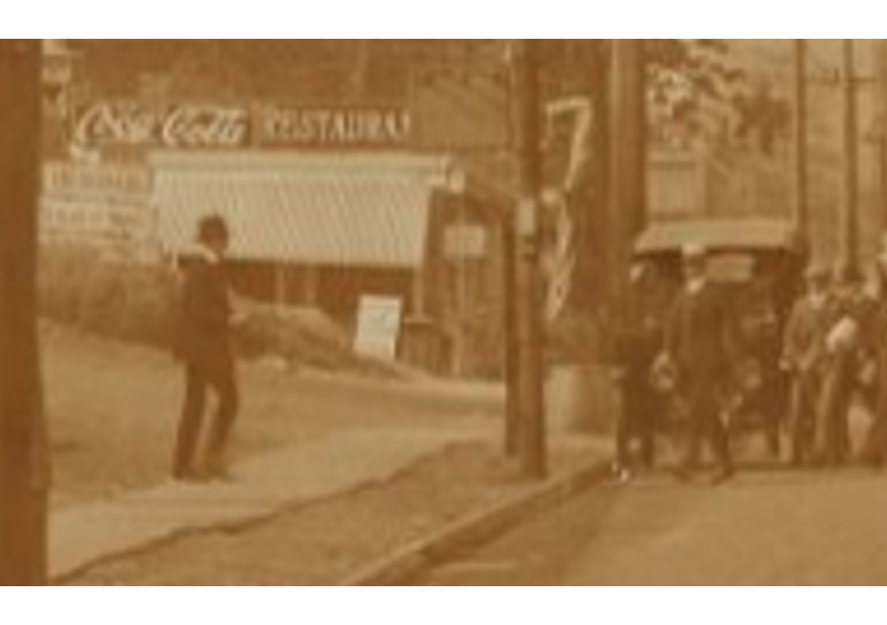
In the post #4992, the last picture seems to be taken from across Broadway looking toward VC House. I’m trying to place the photographer’s position. I’m wondering if he was standing on Old Post Rd behind the restaurant shown in these pictures that were taken around 1917 (from NY Public Library Digital Collection).
In the 1924 aerial view, the van Cortlandt House is in the blue circle, the approximate location of the Locust Grove is in the yellow oval, the Train Station is in the green rectangle and the location of the Old Mill is in the red oval.
The lack of trees in the yellow oval area would indicate that either many trees were felled or that there were few trees to begin with. What constitutes a “grove” might just be in the eyes of the beholder.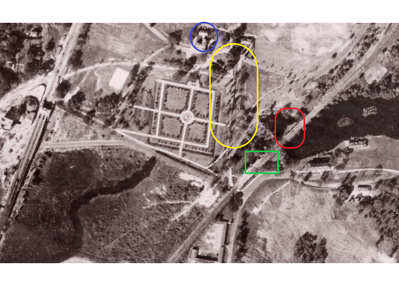
Following the description in Thomas’s article on “The Mill”, “It [the old mill] first stood just below the locust grove northwest of the van Cortlandt Station,”, I place the location approximately within the yellow oval. I show where I believe the old Mill stood in the red square for clarification. The train station is the green square.
I am perplexed that I don’t see either the van Cortlandt House to the rear, if the the photo was taken facing North, nor the train station, if the photo was taken facing South. Also, I can’t place the road with the street lights next to the path with anything in the area. The nearest street in that area is van Cortlandt Park road leading to the Boat House.
Further, the clothing worn by the people in the picture don’t seem to be turn-of the-century style, specifically, the lady’s skirt (unless I’m misinterpreting).
Thomas, you never cease to amaze me with your ability to offer relevant material. Thank you!
There are tennis courts to the east of the Museum House. Do you mean to the east of those, or between them and the Museum? There seems to be a road next to the path. Do you have a date for the photo in the postcard?
-
AuthorPosts