Forum Replies Created
-
AuthorPosts
-
August 31, 2024 at 1:35 pm in reply to: Beautiful Riverdale “Victorian Home” To Be Torn Down–How old is it? #4370
It’s true that it’s very hard and slow to get any property landmarked by New York City, even more so with owner opposition. But it’s much easier and faster to get a property evaluated for State and National Register of Historic Places (S/NRHP) eligibility by the New York State Historic Preservation Office (SHPO). This wouldn’t necessarily prevent the building from being razed, but it would at least ensure that the history of the property is preserved online in perpetuity and might put up some roadblocks to demolition. Unlike archaeological reports, which at the state level are considered privileged information (NYC does not always have the same restrictions), S/NRHP information is available to the general public through the SHPO.
Nick or others, if you want to go this route, you can do so through the Cultural Resource Information System (CRIS) portal as a guest user and be guaranteed an answer within 30 days. The Evaluation of Eligibility Project option on CRIS indicates:
“This process allows a third-party/non-owner to request an evaluation of a property’s State/National Registers’ eligibility. After sufficient descriptive, photographic, and historical information is provided, SHPO staff will evaluate the property to determine if it does or does not meet the National Register Criteria for Evaluation. This request can be used to raise awareness of the significance of historic resources at the local level. Please note, you will need to provide the owners contact information.”
Hope this helps.
Hi Jackie,
I haven’t done any Bronx deed research since the records moved to Queens, but back when they were at the Bronx City Register I think the microfilm/fiche was available. And I think I remember the grantor/grantee original folios once existed for the Bronx when they were at the original City Register office. Are you saying that neither the original copies nor the scanned versions can be found now? If so, that would really be a shame. I’ve found that usually the best sources for up-to-date information are usually the title searchers who do this for a living. If you go in person to Queens, see if you can find a friendly regular and try to pick their brain. Good luck!
Best,
Julie
This is wonderful! Is there a link for the full report on the stained-glass windows? Thanks for sharing.
I can’t speak to the possible Vanderbilt occupation of the property, but I can share some links to cultural resources reports about the site from the New York City Landmarks Preservation Commission website for those who may be interested (apologies if these are already well known to the Facebookers).
https://s-media.nyc.gov/agencies/lpc/lp/1887.pdf
https://s-media.nyc.gov/agencies/lpc/arch_reports/45.pdf
http://s-media.nyc.gov/agencies/lpc/arch_reports/959.pdf
I always love it when Nick brings the receipts!
Hi all, a couple of observations about the artifacts and archaeology. The shell looks more like a clam shell than an oyster shell. The ceramics look like plain ironstone or perhaps some industrial grade refined earthenware — it’s hard to tell from the photos. But both the clam shell and these types of ceramics are found ubiquitously in late nineteenth and early-mid twentieth century archaeological deposits, as Nick described. And it’s equally likely that the clam shell was from food consumption. I’m not sure where in the park these materials were found based on the original post, but it’s very possible that this could just be from an informal dumping episode or the materials were mixed with imported fill that has nothing to do with the original location. Also, it’s extremely common to find materials dumped down a hillside, or in a ravine. Much cheaper and easier to do that than cart it away somewhere else. You’d be amazed how common it is to find abandoned appliances and even old cars dumped down hills! Thanks to the OP for sharing!
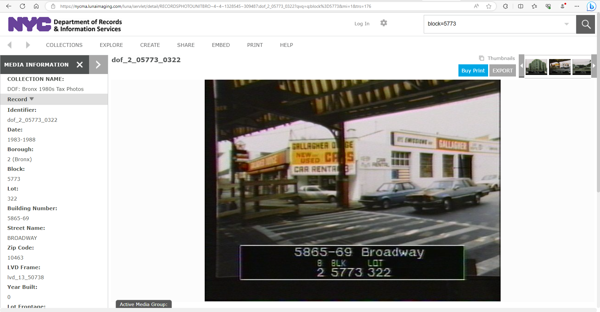
And here is the 1980s version.
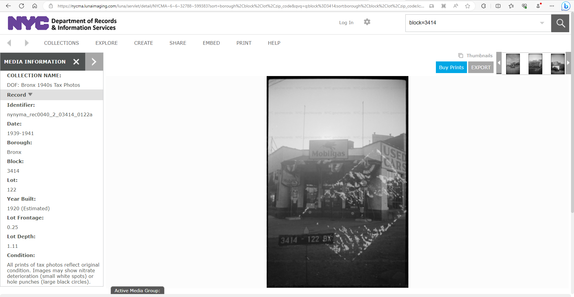
Here is the tax photo of the property from ca. 1940.
This is a really wonderful article, Nick. It’s incredibly well researched and documented (yay endnotes!). I especially love the dynamic maps! And as someone who also does a lot of deed research, I can attest to how challenging it can be to reconstruct past landscapes from antiquated documents. Well done.
In terms of the archaeology at the Van Cortlandt House, folks might be interested to see what has been found there during previous excavations. Here is the link to the New York City Landmarks Preservation Commission’s Archaeological Repository for the property. There are 15,723 artifacts in the database, and many of them have been photographed. However, it does not appear that any of the artifacts, based on their date ranges of manufacture, were clearly associated with the 17th century occupation referenced in the article. Here’s hoping that future work may uncover some materials from the early Dutch settlement on the property.
Thank you for your kind words, Nick. I sure could have used your archival expertise back when I was writing this report, though! I’m glad to see there is at least one Revolutionary War era map that includes the fort after all. It seemed as though it had to exist, although at the time we could not find it. Kudos to the Mount Vernon library for digitizing it and to you for locating and sharing it!
This is really wonderful! Kudos to all involved.
Wow, I should have figured that this group would have already known about the West Side Tennis Club and its history — clearly I am late to the party! I love the photos you linked to the 1911 Davis Cup tournament, which I had not seen before. And what a tale of transformation of the block containing Gaelic Park! I always learn something new here; thanks again for sharing.
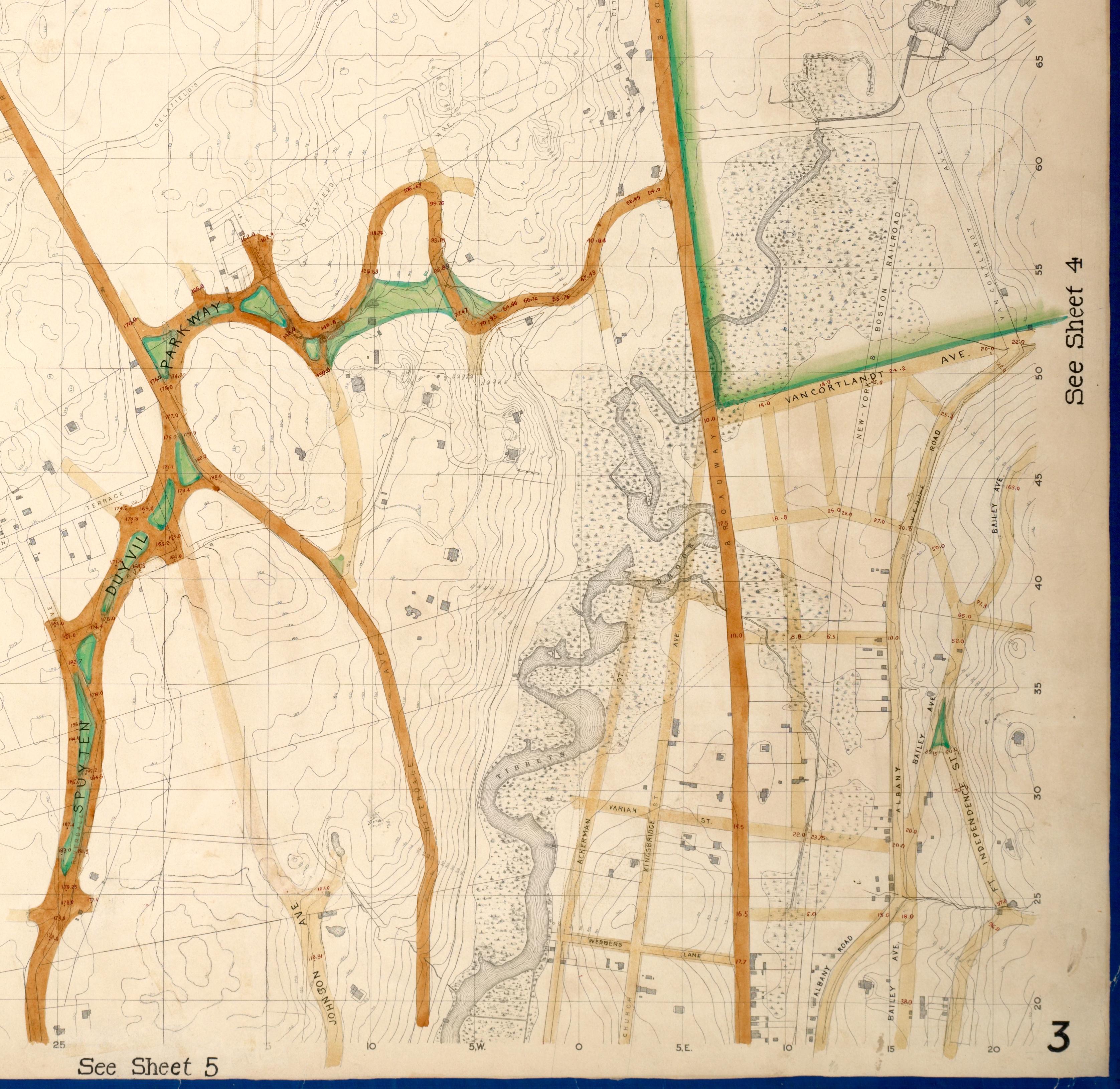
Hi folks, with regard to the image from 240th Street, I have a few more pieces of the puzzle to add. At least on historic maps from the 1870s onward, the roadway east of Broadway at 240th Street was never called 240th Street, but always Van Cortlandt Park South. That road was a “paper street” for a number of years before it was actually constructed, as were a number of other streets in this area. A very detailed 1873 topographic map showed that the marshlands surrounding Tibbetts Brook were substantial on the west side of Broadway where 240th Street would later be built, but fairly limited on the south side of Van Cortlandt Park South.
Here is a cropped version of the 1873 topographic map. https://digitalcollections.nypl.org/items/734f7d13-ed0c-9630-e040-e00a1806276f
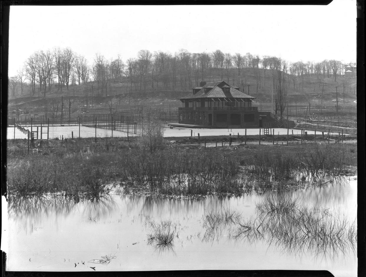
In 1908, property east of Broadway and south of Van Cortlandt Park South was leased by the West Side Tennis Club and a new clubhouse and tennis courts were constructed there. In conjunction with a report I wrote last spring about the now shuttered Catholic school and church property at that same location, I found some wonderful images of the West Side Tennis Club’s property, beginning in 1908, at the New-York Historical Society and the Museum of the City of New York. I’ll post a few of them here. The West Side Tennis Club moved to Forest Hills, Queens, in 1913 and is still active today. They have a nice image of the old clubhouse on their website as well.
Here is the 1908 photograph of the tennis facility being built, from the New-York Historical Society. The view is looking southeast from Broadway. Although the citation suggests 1920, this is erroneous. Tennis club at Broadway and 240th Street, Bronx, undated (ca. 1920). | New York Historical Society | Digital Collections (nyhistory.org)
And here are a couple more photos, from the Museum of the City of New York. The first is the same view as above, but a few years later. The second view is looking north with Broadway on the left. Both of these are from ca. 1910.
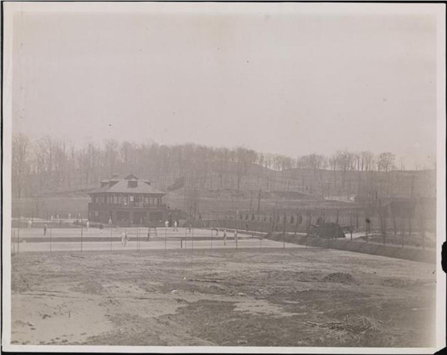
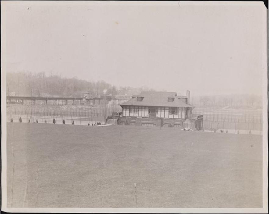
Based on these images and their dates, it seems more likely that the image from 240th Street is not looking east, but probably is looking west, as Nick first suggested. Thanks for the chance to revisit this very interesting area!
Hi, I can help with when the property was sold out of the Whelan family. A search on ACRIS for Block 3267, Lot 54 turns up a deed, from 1998, from the estate of Helena Agnes Whelan to a realty company. Can’t seem to attach .pdf files here, but it’s easily found. Also, if you do a search on 3129 Bailey Ave on fultonhistory.com there are lots of hits referencing Whelan’s garage through the early 1970s at least. One ad said they began their business in 1914. Good luck with your research!
An ad from the Riverdale Press in 1961!
Jim Dwyer, the author of the article, went on to have a very successful and award-winning journalism career, and wrote a number of books. He used to write the “About New York” column for the New York Times, which was really wonderful. Sadly, he died about two years ago. Nice artifact from his college newspaper writing days.
Great sleuthing, Nick! You can add this tidbit to your next tour of the park.
There’s always the National Archives electronic database, which would get you part of the way there.
The World War II Army Enlistment Records File and Access to Archival Databases | National Archives
NARA – AAD – List of Series – Wars/ International Relations: World War II (archives.gov)
But this is only a partial list for the Army, I believe, not the other branches of the military. And the database can be searched by county (Bronx) but in the pre-zip code era, not by neighborhood. So you would get a LOT of hits that might not necessarily be from the Riverdale area. Still, maybe a National Archives expert could give some better advice as to how to better use their system to get what you want.
Hi Don, I don’t know this answer for sure, but it’s possible municipal water service never made it up to the heights of Inwood Hill before the area was acquired for parkland in 1916. The 1913 Sanborn map pages do not indicate that there were water lines under the streets there. And since these were fire insurance maps, they were usually pretty good about showing where the water lines existed.
We have also found that the dates that infrastructure became available did not necessarily coincide with when buildings were actually hooked up to city services. Many times the hookups lagged by a number of years for various reasons. And often wells and cisterns continued to be used many years after piped city water was available, either as a supplemental water source, or simply because it was there and free! Hope this helps!
Hi Don, nice to see you on this forum. Your map looks wonderful and the images are very cool! I remember seeing some features in Inwood Hill Park that seemed to suggest earlier development and now I know what I was seeing. Thanks for sharing.
I would just offer one bit of caution: if you are intending to share this information more widely, you might remove mention of the wells and cisterns that still remain in the park. As you may know, these shaft features, along with privies, became receptacles for trash after their use life ended, and with privies, sometimes while they were still in use. Archaeological sites often attract pot hunters who know to pinpoint shaft features for potential goodies, such as bottles. Digging in woodlands of NYC Parks is illegal, although pot hunters are not necessarily the most law-abiding sorts. It’s very possible these features have already been looted over the years, but in case any are still intact, it’s probably best not to draw attention to them too widely. Thanks for your understanding. Best, Julie
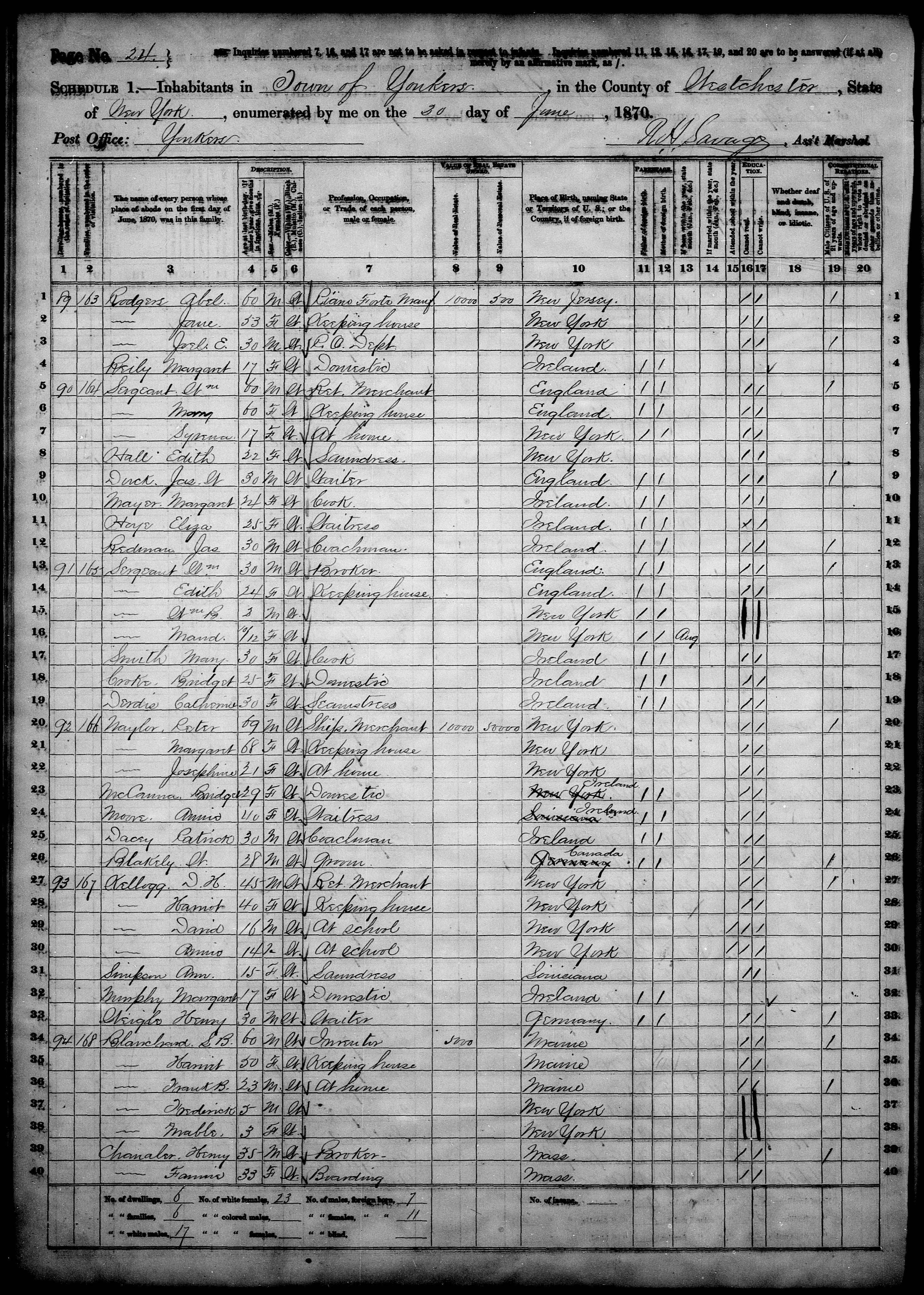
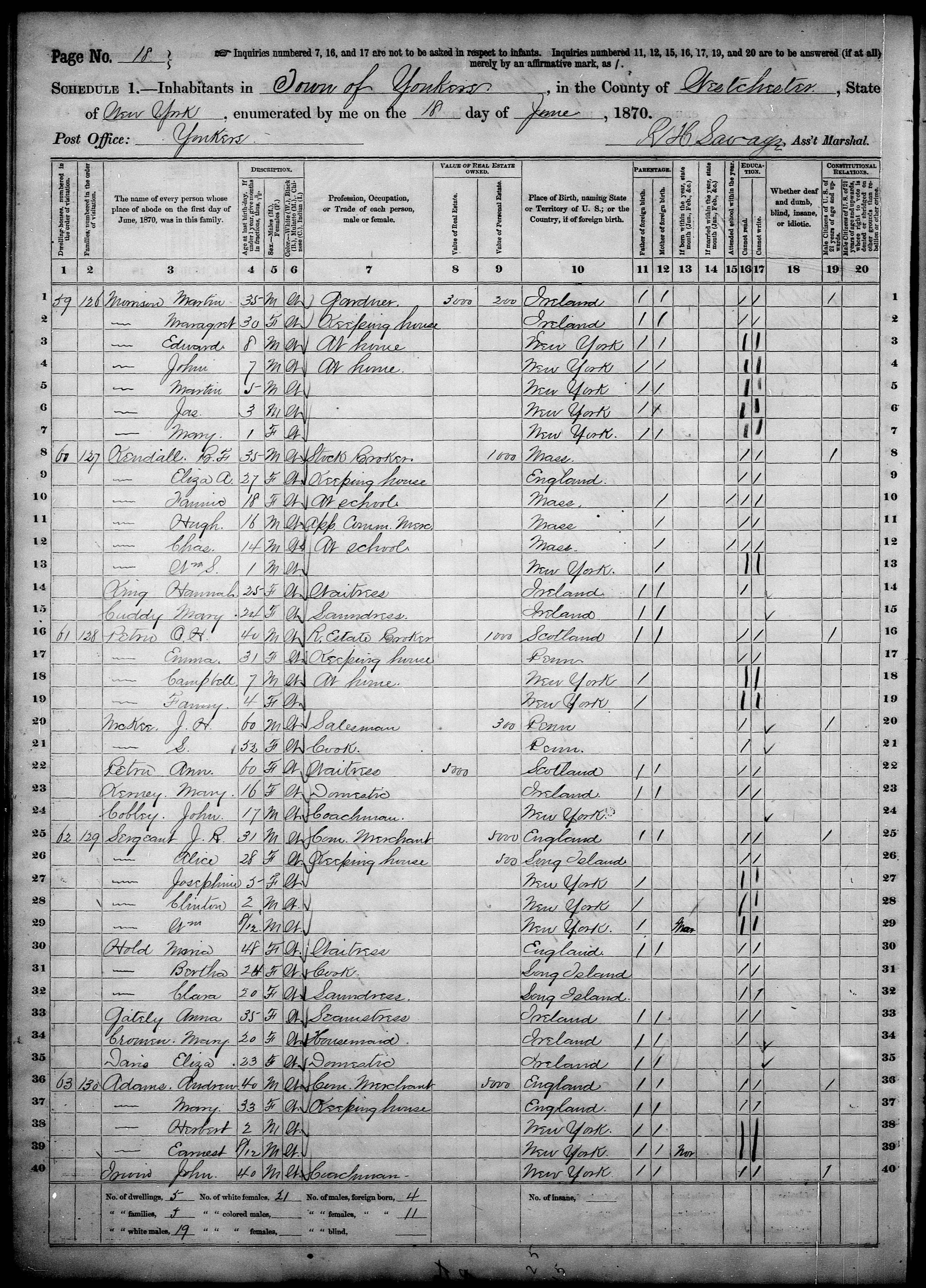
Here are the listings for William Sergeant Sr. and Jr. in the 1870 federal census for Yonkers.
I agree, Nick, this is a wonderful post and some beautiful paintings!
I can help a little about William Sergeant, who was the grandfather of William Sergeant Kendall. The 1870 federal census had a number of Sergeant family members listed for Yonkers, as the neighborhood was then part of. There was a William Sergeant the father, William Sergeant the son, and several other children, including Elizabeth (Eliza) Sergeant Kendall, the mother of the artist. She was married to Benjamin Franklin Kendall. The census records show that B.F. Kendall did not have any real estate assessed, suggesting that his family was living in one of the houses attributed to William Sergeant on the 1868 Beers map. The order of the census listings suggest that William Sr. and William Jr. were living in the two bigger houses on Independence Ave. while the other Sergeant children likely were living in the smaller houses on Sidney and Troy Streets. Thanks for introducing this family to us!
All of these photos are really wonderful! With regard to the image of the bottles, the plastic caps are probably older than you’d think. They were first introduced in the late 1920s. Many of the bottles in the picture are medicinal bottles, including the brown one and the super skinny one, and probably a few others. The opaque white jars were for cold cream or the like. The small wide-mouthed clear bottle was for milk. Thanks for sharing, Nick.
-
AuthorPosts