Forum Replies Created
-
AuthorPosts
-
After searching where I put the Dash’s Lane postcard, I thought it was time to reorganize the Buck section of my 6,736 postcards. There are 37 Buck postcards that have a Bronx connection and an additional 7 that are strictly in Manhattan. The 4 that I am missing are
Spuyten Duyvil swing Bridge (need)
Fordham Club House, Morris Ave and High Bridge Road (need)
Views of Dyckman Homestead on Harlem Ship Canal. Built 1810 (need)
Floating Old Ship Canal Draw Bridge from 221st Street and Broadway to 207th Street ( need)
I added a mystery postcard of a scene in Spuyten Duyvil that I do not know the specific mansion owners name or
specific address.
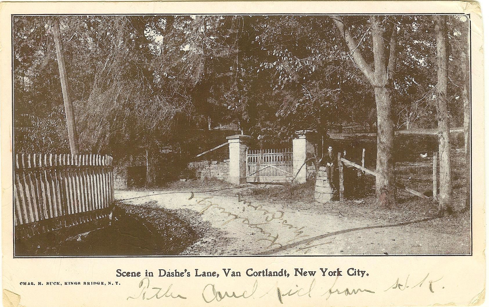
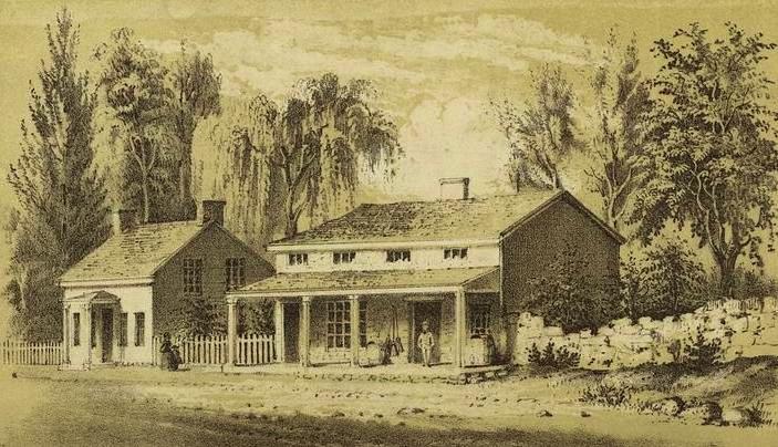
Posted below is “Scene in Dashe’s Lane, Van Cortlandt, NYC”
I have attached below, a listing of postcards published by Charles H. Buck of Kingsbidge, in the Bronx, with my earliest postmarked 1906:
1 Bailey Avenue, Looking South from West 230 St
2 Broadway and 230th Street as it looked in 1890
3 Bronx Catholic Orphan Asylum (for Girls), Sedwick Avenue & Kingsbridge Road
4 Church of the Mediator, Kings Bridge Ave, Kings Bridge, NY
5 Convent of Jesus Mary, Church St, Kings Bridge, NY
6 Dutch Garden at Van Cortlandt Park
7 Elmhurst Residence of Mr. G.P. Morosini, Riverdale-on-Hudson, NY
8 Engine Co. 52, N.Y. Fire Department, Kings Bridge
9 Engine Company, 81, N.Y.F.D., Kings Bridger, NY
10 Hadley’s or Farmers’ Bridge, Harlem River & Kings Bridge Road
11 Hagman’s Tree, Spuyten Duyvil on the Hudson, New York City
12 Historic Kings Bridge of Revolutionary Days
13 Kings Bridge Police Station, 40 Precinct, Boston Avenue
14 Lake & Boat House, Van Cortlandt Park
15 Looking West from Webb Academy, towards the Palisades, Kings Bridge, NY
16 New York Public Library, Kings Bridge Branch
17 Old Godwin Mansion, 228 St Broadway
18 Old Kings Bridge Hotel. A Popular Road House of Former Days
19 Old Station of the NY Central RR at KingsBridge
20 Old Van Cortlandt Mansion, Van Cortlandt Park
21 Power House, Looking South from 225 St & Broadway
22 Presbyterian Chapel at Spuyten Duyvil, NY
23 Prison Window from the Old Sugar House, in Van Cortlandt Park
24 Private Residence, Spuyten Duyvil on Hudson
25 PS No. 7 – Kings Bridge, N.Y.
26 Roman Catholic Orphan Asylum. ( for Girls) Sedwick Ave and Kingsbridge Road NYC
27 Scene at Van Cortlandt Park – The Old Mill Waterway
28 Scene in Dashe’s Lane, Van Cortlandt, NYC
29 Seton Hospital, Riverdale Ave, Spuyten Duyvil, NY
30 St Stephen’s ME Church, Marble Hill, Kings Bridge
31 Spuyten Duyvil Swing Bridge
32 Temporary Terminus of Subway at 230 St, Kingsbridge, NYC
Very nice selection of images…Thank you – Tom Casey
Nice find……The Ladies and all the buildings are all in Manhattan.
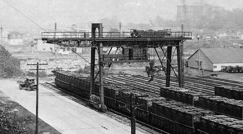
August 17, 2019 at 8:26 pm in reply to: The Spuyten Duyvil and Port Morris Railroad – Part 2: Through the Hill #1098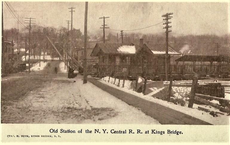 August 17, 2019 at 8:25 pm in reply to: The Spuyten Duyvil and Port Morris Railroad – Part 2: Through the Hill #1097
Now if you can help me locate where the old station was, I would be very appreciative.
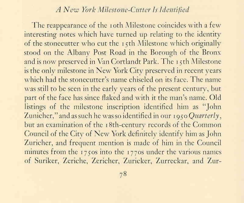
John Zuricher was a gravestone carver of the mid-to-late eighteenth century. He lived with his wife, Elizabeth Ensler, and their ten children in New York City, but produced gravestones that can be found across the Hudson Valley, Long Island, and New Jersey, and even in Pennsylvania and South Carolina. As a stone mason, he worked on New York City Hall and made milestones for the Albany Post Road.
The stone in the photos above and below was created by Zuricher out of red sandstone for James Wright, who died in 1776. The decoration at the top is a round-faced cherub head with a crown of spiraling curls and quite distinctive wings, in which the feathers are laid out in a grid. There is also some sort of decorative flourish at the very top.
Anyone who has read James Deetz’s masterpiece In Small Things Forgotten can tell you that there are three major phases of gravestone iconography in early New England and New York: death’s head, cherub, and urn and willow. The cherub was a direct descendant of the death’s head, and retained some of its features in a vestigial or reinterpreted state. For instance, that little nub of a chin at the bottom of the cherub’s face evolved out of the jaw of the death’s head – shown in this example. Furthermore, this stone represents the “missing link” between the death’s head and the cherub.
It seems that Zuricher dealt exclusively in cherubs, which would make sense for the time period in which he worked (about 1749 to 1778).
Thank you….but not the answer ?
Best guess Exterior St where Tibbets brook empties into Harlem River
 Otto and Dieter –
Kingsbridge Yard was commonly known as FH Yard, for FH Tower that controlled the yard lead at the east end of Spuyten Duyvil Rock Cut. I believe that FH came from a name for Fox Hollow, but I can’t document that. The freight station was known officially in tariffs as Kingsbridge, but it was in the time-table as FH freight station.
FH yard was actually on the original alignment of the NYC main tracks from when they passed north of Kingsbridge. After the Harlem River Ship Canal was cut through, the RR was realigned along the canal to avoid some perilous curves. That also accounts for the little piece of New York County and the Borough of Manhattan on the mainland adjacent to The Bronx. The river was moved south, but the borough boundary remained where it was.
I don’t know when FH Yard closed down, but it was running full blast when I worked there in 1960-61. There were several traveling switchers based there, which later moved to Yonkers. The primary business was an automobile warehouse run by Kenosha Auto Transport for distribution of American Motors Ramblers, etc.; a freight house, and a team track. There are some others around who were there when FH shut down, and they probably have a better handle on the date. I think it happened in the middle of the 1960’s, just before Penn Central. There was a new yard office at Yonkers in 1963 or 1965, and I think that was on account of moving the crew headquarters up there.
In 1960, the Ramblers were moving from Kenosha, WI to FH in double-door box cars known as “auto racks” from the internal arrangement of hoists and ramps in the cars. In 1961, they were moving in bi-level cars, also called “auto racks.” The Hudson Division didn’t have sufficient clearances to run tri-levels.
Bronx Terminal Market was served by the NYC up to Penn Central days, when most of the perishable traffic went to Hunt’s Point (after PC got the New Haven) or just to trucks. BTM was owned by the City of New York, and everyone there rented their space from the City, even the NYC for the yard office. It was right next to another space leased by Hans Holterbusch, the Lowenbrau distributer for the area. I always avoided the opportunity to violate Rule G when I worked at BTM, even though I was 18 years old, and that was drinking age in New York State. I enjoyed my RR job too much, and in that part of the world I really needed to keep my wits about me all the time. I had an excellent relationship with the NYPD from the 44th Precinct, on the hill near High Bridge. They often stopped by for a cup of coffee around quitting time, and they were usually good for a ride over to catch a train at High Bridge.
Fordham road trian station bookstore and Fordha u. behind man
July 29, 2018 at 10:43 pm in reply to: The Area Around the Van Cortlandt House in the 18th Century #497[caption id="" align="alignnone" width="851"]
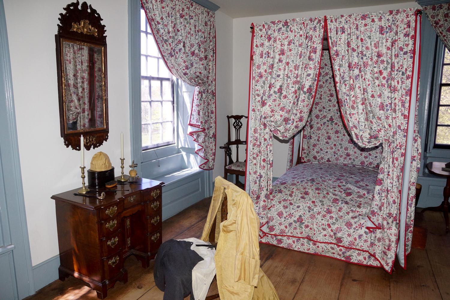 Place where Captain Rowe Died in his bride to be arms. ( Elizabeth Fowler )[/caption]July 29, 2018 at 10:36 pm in reply to: The Area Around the Van Cortlandt House in the 18th Century #496
I was asked by students of PS 81, Robert J Christen School in Woodlawn about ghosts at the Van Cortlandt Mansion. The students recently visited the Morris-Jumel Mansion in Manhattan and wanted information before they visited the Van Cortlandt Mansion. Except for the strange and scary gargoyles that adorned the VC Mansion, I had never heard of a VC Ghost story. Until I went home that night and started my research. Sure enough….I found out that the ghost of Captain Rowe, of the British Pruicsbank Jaegers roams the house during the night of his death. He was shot while on his last patrol by men of Captain Pray’s company. He resigned his commission, in order to get married to Elizabeth Fowler of Harlem. His wounded body was laid to care in the Washington Bedroom at VC. When his bride arrived with her mother, Captain Rowe died in her arms. Part of the story can be found at https://books.google.com/books?id=E1A2AQAAMAAJ&pg=PA214&lpg=PA214&dq=Pruicsbank+Jaegers&source=bl&ots=ZYRHrsVMSx&sig=eAWV05VXhfl9Y2vqyIsM_ClL8AM&hl=en&sa=X&ved=2ahUKEwjMhPKMrsXcAhVLVd8KHXJzAxEQ6AEwAXoECAMQAQ#v=onepage&q=Pruicsbank%20Jaegers&f=false
 Van Cortlandt mansion and out buildings
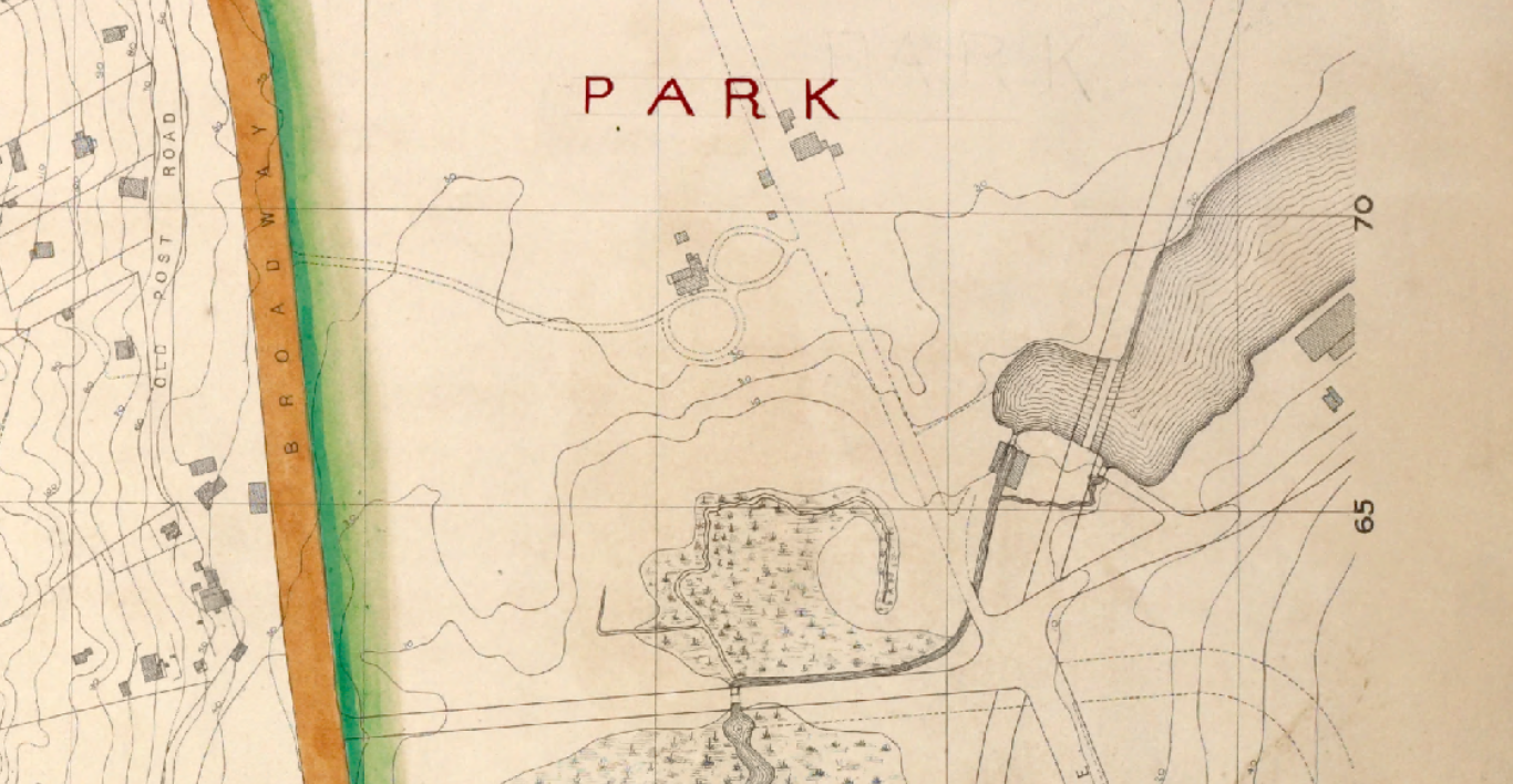
Every time I see a photo or drawing of a Bronx scene, I try to confirm with maps or other sources. For the parade grounds and Burial grounds I am now searching for maps and photos. Hope I get lucky.
[caption id="" align="alignnone" width="811"]
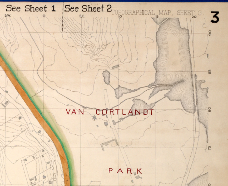 1873 Topo map Van cortlandt mansion to the south[/caption]
Tom Casey
April 11, 2018 at 6:18 pm in reply to: Family Histories and Living in 19th Century Spuyten Duyvil #437DAN,
At the White Plains County Clerk, Real Estate Office, you can search on computers, based on names
You will quickly find deeds or mortages, I am sure for Van Tassel etc The deed may say what and when the house was built….. Not sure if they have records from the building dept available ? Do you live close bu in Yonkers ?
Then you can move on to family members
April 10, 2018 at 4:17 am in reply to: Saving the Historic Gravestones of the Berrians in Van Cortlandt Park #434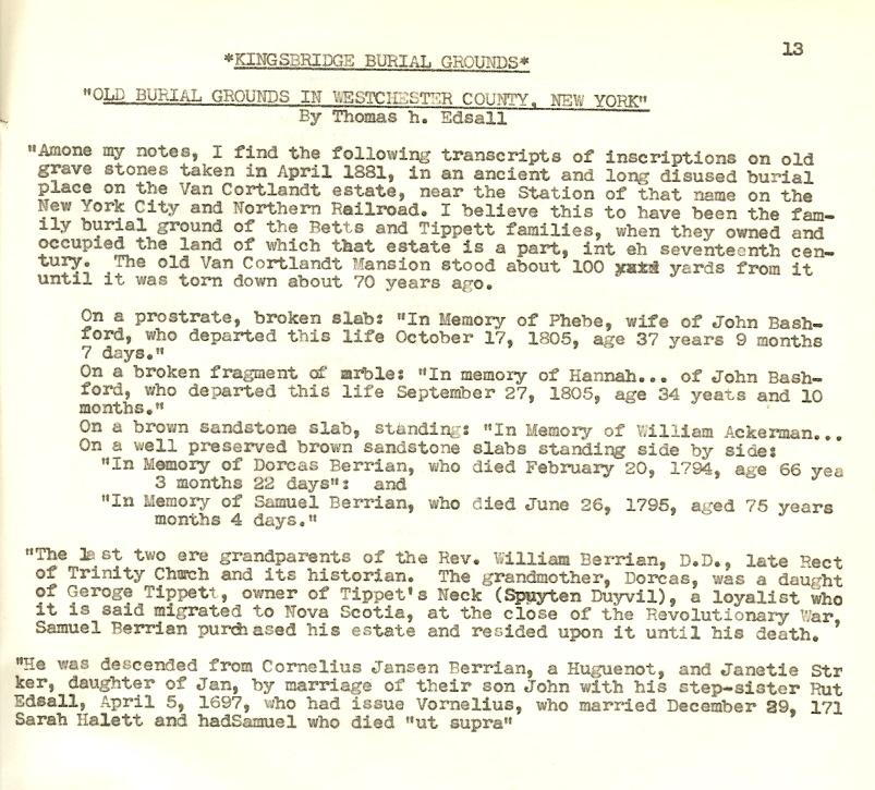 April 10, 2018 at 4:16 am in reply to: Saving the Historic Gravestones of the Berrians in Van Cortlandt Park #433
The photo was from 2004 but I have brushed the leaves around the area recently and found the same stones. See article attached
 April 9, 2018 at 11:24 pm in reply to: Saving the Historic Gravestones of the Berrians in Van Cortlandt Park #431
This is very shocking….I was not aware of the mis-management of these headstones. I wonder if our local leaders are aware ?
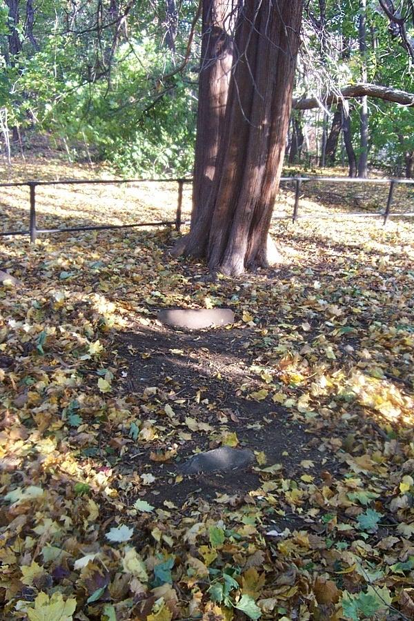
I have posted a picture of the burial plot before the recent removal of the headstones
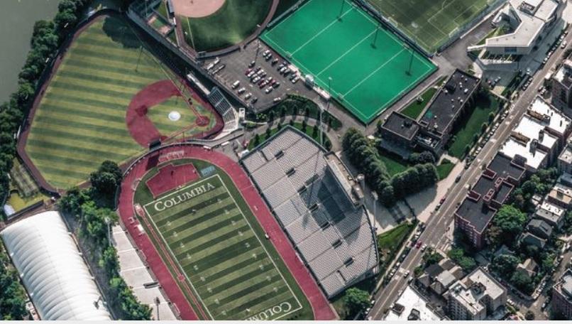
April 9, 2018 at 11:16 pm in reply to: Johnson Foundry and Harlem River Ship Canal – Scientific American #430Maybe the view to the right os more like Columbia Fields
[caption id="" align="alignnone" width="703"]
 Blie Bell[/caption]
Yes…The Blue Bell was along the old Kingsbridge Road or ” Broadway ” in Manhattan
April 9, 2018 at 10:24 pm in reply to: Interesting Agreement for 1500 tons of Iron at Spuyten Duyvil Foundry #428Southern Pacific Railroad, one of the great American railroad systems, established in 1861 by the “big four” of western railroad building—Collis P. Huntington, Leland Stanford, Mark Hopkins, and Charles Crocker.
The Southern Pacific Railroad was founded by a group of businessmen led by Timothy Phelps.
April 9, 2018 at 10:13 pm in reply to: Johnson Foundry and Harlem River Ship Canal – Scientific American #427[caption id="" align="alignnone" width="636"]
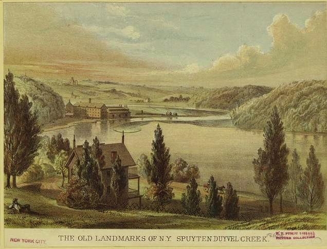 View of Spuyten Duyvil creek from a Valentine Manuel[/caption]
A view from the top of the railroad cut to Where the Broadway Bridge will later be built
April 9, 2018 at 10:11 pm in reply to: Johnson Foundry and Harlem River Ship Canal – Scientific American #426An other view from the top of the hill looking across to the new inwood playground area.

-
AuthorPosts