Forum Replies Created
-
AuthorPosts
-
Grew up on Kingsbridge Heights and not to my 20s did my family get a car. We use to have it serviced and yearly inspected at Whelan’s. So at least through the 70s it was there and later. At some point I believe it became a tire dealership.
I would agree that the great kill could be the Harlem River. But I also feel it could be very likely describing the south Bronx across from Manhattan. It states land runs East to West ( across the Bronx) opposite the flat of Manhattan (Harlem) at the head of the Kil (East River across bottom of the Bronx) across from high hill (middle Harlem and north/Hamilton Heights/above old Polo Grounds etc) by the flats. Again this was description of 1639.
The land was bought by the West India Company for future use. Likely the same land that the sachems who signed the contract with Jonas Bronck. You see a lot of land sales being bought and sold over and over with each new purchases.
Here is the translation, there is a hot link above see above – 1639 land deed
This day, date as below, appeared before me Cornells van Tienhoven, Secretary in New Netherland, Tequemeck, Rechgawac, Packamieus, owners of Kekeskich, who in the presence of the undersigned witnesses voluntarily and deliberately declare, that in consideration of a certain lot of merchandise, which they acknowledge to have received and accepted before the passing of this act, they have transferred, ceded, conveyed and made over as a true and lawful freehold, as they herewith transfer, cede, convey and make over to and for the benefit of the General Chartered West India Company a piece of land, located opposite to the flat on the island of Manhattan, called Keskeskich, stretching lengthwise along the flatlands, which runs behind the Island of Manhattan mostly east and west and beginning at the head of the said kil and running opposite of the high hill by the flatlands, namely by the Great Kil, with all rights titles etc.
Done at Fort Amsterdam, the 3 August 1639.
Cornelis van der Hoyten
Davidt Pietersen de Vries
Cornells van TienhovenHi Tom. I don’t think we can read these documents with any certainty in comparing to today locations. This is a very early old document 1639. It was in Dutch translated in English. Groot in Dutch means large, big and great. So large Bronx Kill could work. Perhaps to them 400 years ago it was a big river. During the Amer Rev the British tried to send a fleet up the Bronx River. It Didn’t fit. One of the keys between the document and what I commented was fact that 2 indian sachems were the same. Leads me to believe it wasn’t Staten Island or NJ but likely the Bronx area.
I don’t take all these early translated documents and Native place names too literally. Native Indians did not have a written language. Their names and place name were phonetically written by the person writing the document. Similarly to immigrant who had their names changed by customer agents. These are a good example of “you say tomato I say tomahto”.
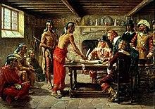
Kil is Dutch for steam or water so could be any location. Two of the native American chiefs referenced above were same who sold the name to Jonas Bronck. On April 22, 1642 a peace treaty was signed at Bronck’s homestead between Dutch authorities and the Wecquaesgeek sachems Ranaqua and Tackamuck. Jonas Bronck’s house was built by a promontory at the juncture of the Harlem River and the Bronx Kill across from Randalls Island this event is portrayed in a painting by the American artist John Ward Dunsmore.
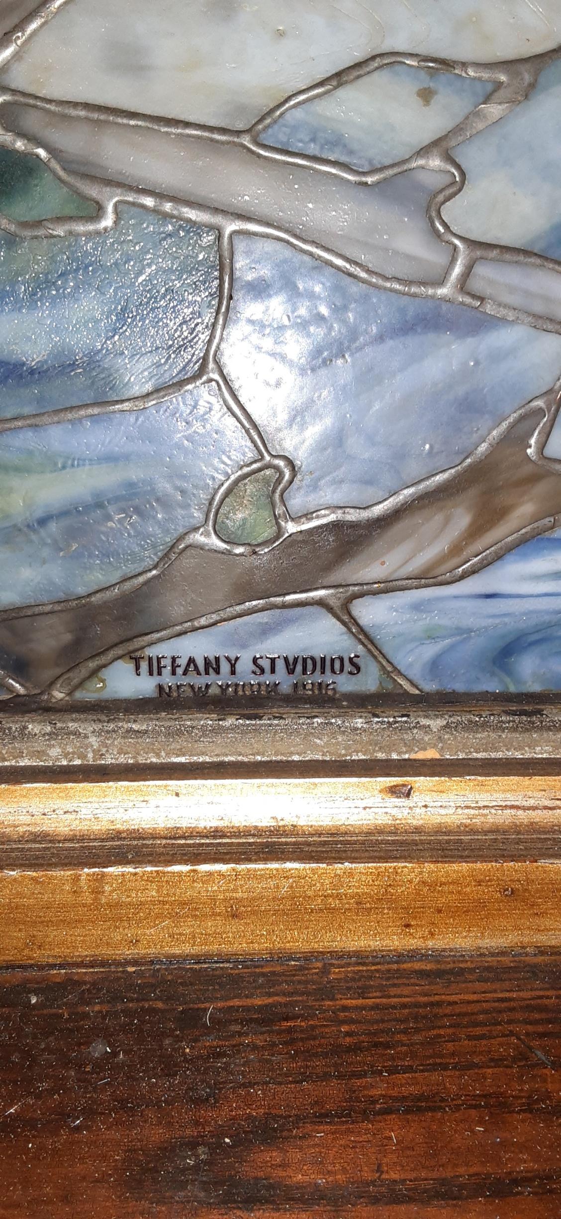
As of Dec 2 2022 the Edgehill Church of Spuyten Duyvil is now property of the Kingsbridge Historical Society !! That early photo is very interesting and new to me. I was down to the church to take inventory and measurements yesterday. I took some close ups of the windows and hiding in plain sight is the answer to when the Tiffany windows were installed…1916. And as Nick mentioned each have large brass plaques dedicating the windows to I.G.Johnson, and Johnson family children by the dates given. Each Window is signed Tiffany Studios New York 1916. And now we all know the rest of the story. By the way did I mention that Edgehill Church is now the property of the Kingsbridge Historical Society, the oldest local historical society in the Bronx . !!!!!!
Looks like the Catskills on an episode of The Marvelous Mrs. Maisel. I give up.
I have feeling that a pool in the shape of an R was never actually built. But if i had to guess perhaps Riverdale Neighborhood House.
Mosholu Hall I believe was in the area today of 242street and Broadway. This general area was know as Mosholu, a village or hamlet of old Kingsbridge.
Tom is correct. Look at The city line today, it stops right at the Catholic college of Mount Saint Vincent.
Nick nice find and good research making all the connections. Regarding the house location for the doctor. I’ve always thought of the stone path mentioned as part of the old Albany Post Road that turned left at the top past the VC house over Bway to the Post Road. At the bottom of this road is the split off that went under the old RR bridge that was the Road to Miles Square. Both ancient roads in this area. So I think you are correct in identifying the location of the Doctors house east of this road towards the mill and both maps are ‘correct’.
Interesting that the proposed design of the new Seton Hospital never built looks a lot like the the present White Hall apartment complex at 232St and HH Pkwy.
Seton Hospital? Looks like the Palisades in background and the cross.
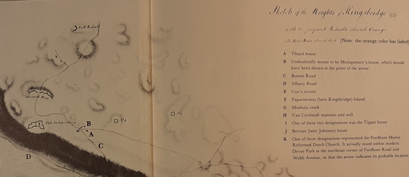
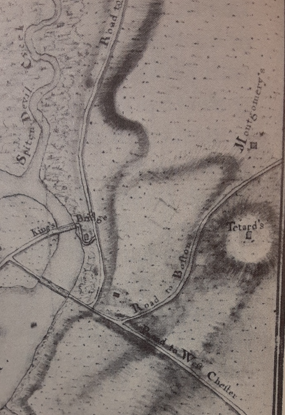
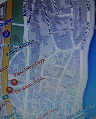
Here are a few maps showing Tetard’s house , Montgomery’s and Fort Independence. The Old Boston Road and Albany Post Roads both started at today’s juncture of W231st and Albany Crescent, basically in front of the old P&K’s, todays’s Bronx Public. The Boston Post Road ran along today’s Albany Crescent, past the Fire House, over Bailey Ave and up the hill turning left on Heath Ave and up around NE to Ft Independence St and Sedgwick Ave. The road today shows the same path as it was back in 1776. The following maps will help show the location of J.P. Tetard’s house.
Nice Find Nick on Tetard’s school ad !
Tetard’s house is thought to be the former manor house of Jan Archer, the manor of Fordham. It’s thought to have been located south of Fort Independence St along approx Kingsbridge Terrace. Tetard was a neighbor of Gen Richard Montgomery whom he later served as his Chaplin to his Army when it attacked Quebec in 17775 where Montgomery was killed. Tetard’s house was later used for the Hessian General wilhem von Knyphausen before his attack on Ft Washington 1776. It’s been described as s stone block house.
New Rochelle was settled early 1688 by French Huguenots. Not sure what Cronin taught while we know JP Tetard taught French. The names listed on the document for Cronin are family names in the larger area of Kings Bridge at that period. Streets are named for Bussing in today’s East Bronx, Vermilye down in Inwood and Odell in Yonkers. Perhaps Cronin traveled to the homes of the students and not a physical school.
John Peter Tetard was a teacher but also a minister and an Army Chaplin. He farm and house was located approximately south of today’s Fort Independence St. His farm abutted that of Maj. General Richard Montgomery. Tetard was a Chaplin with Montgomery’s army and was with Montgomery when he was killed in 1775 in the attack on Quebec.
Two quick points to note:
1)West 259th Street was originally named Rock Street St. The present Con Ed new high pressure gas project is finding this out the hard way.
2) Also note the first floor street level in the old photo as compared to the present day photo. The installation of sewer mains in the early 20th C. Necessitated the raising of the street level. But not as drastic as on Corlear and Tibbett Ave down in Kingsbridge.
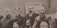
Small world as I came across a book on American art and came across this photo that includes two of the artist in this thread standing together in 1907. William Sergeant Kendall and George Willoughby Maynard both members of the National Academy of Design. Both with a connection in art and both living in the Bronx at the turn of the 20th Century.
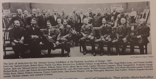
GW Maynard top at left and Kendall top 2nd from right.
Believe the location of the iron railing in foreground of the 1915 photo indicates it was taken from the Godwin Island bridge that once ran parallel to Broadway at 230th Street over the old Spuyten Duyvil creek at that time filled in. Today the bridge would have been from Dunkin Donuts south across 230th St to SW corner and Marble Hill houses.
Public records show it was built 1910 but most early building land records dates are suspect so could have been used by johnson foundry at one time.
A Few other local artist two of which were members of the Kingsbridge Historical Society(KHS). Charlotte Livingston (1898-1991) was an early members and later trustee of the KHS. She studied at the Art Student league and National Academy of Design where she met her future husband. She was also admitted as a member of the SalmagudiClub first class of women artist. Charlotte mainly painted in water colors and her style is very much like her contemporary mentioned, Georgina Klitgaard. Charlotte painted the painting below in 1919. It’s a view looking south on Giles Place Bronx towards Fort Independence Street.
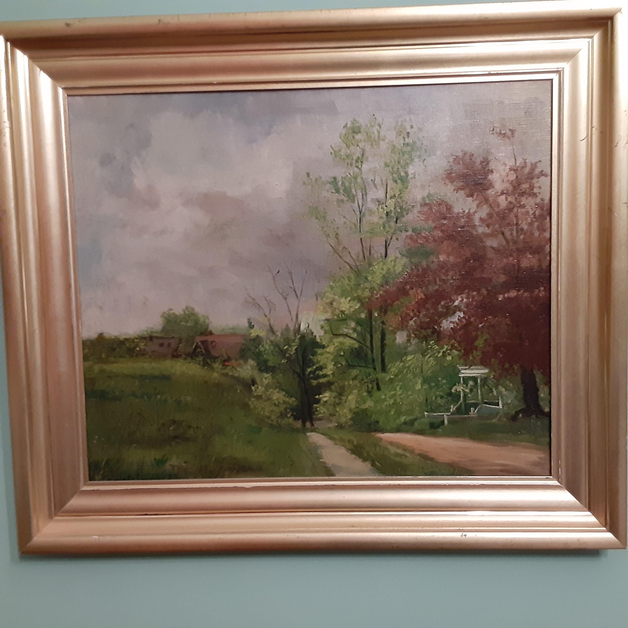
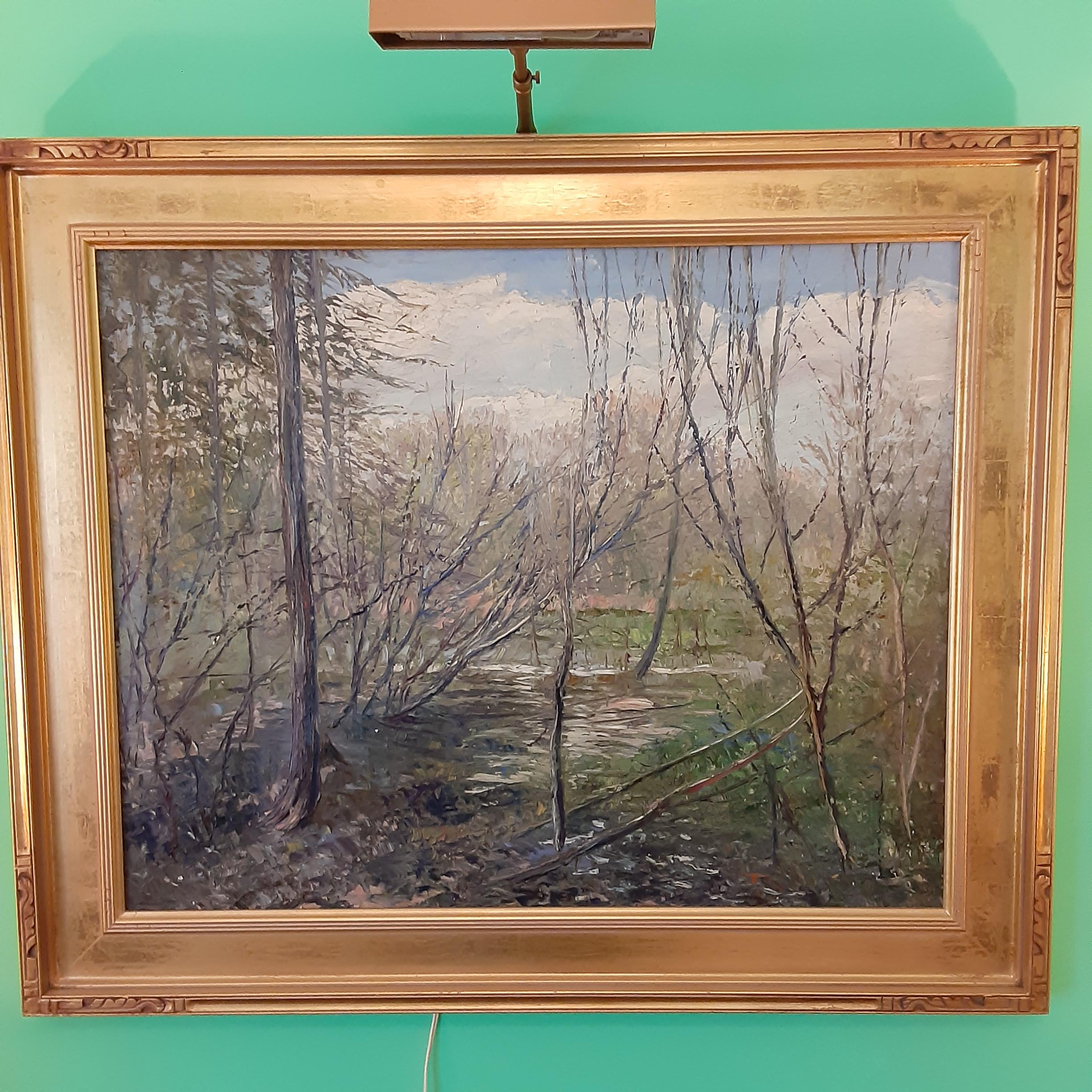
Of interest is the house at lower right which belonged to one of her teachers GW Maynard. Charlotte was a student of a nationally known artist, George Willoughby Maynard (1843-1923) a painter and muralist(library of Congress and Boston’s Trinity Church) and National Academician and teacher. Below is an example of his work entitled “Mermaids Pool” 1912.
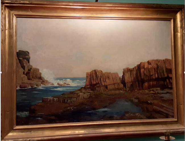
The other Kingbridge Historical Society member was Francis vanderveer Kughler (1901-1970) who was born in Kingsbridge. A professional artist known for landscapes and portraits. He was a president of the Salmagundi Club. Below is a painting titled “Bronx Park 1938” which captures a spring day in the Bronx.
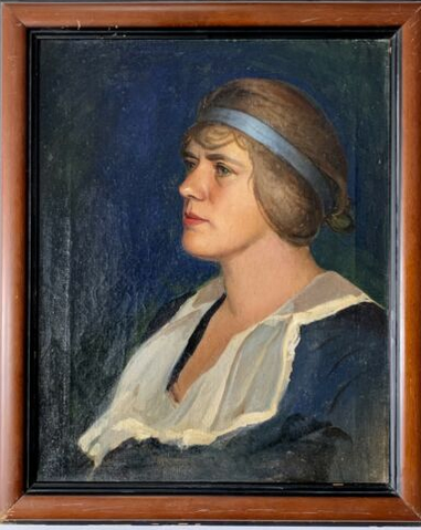
Kughler’s landscape style was very similar to Ernest Lawson who painted locally and who is a topic for another time. An early portrait painting by Kughler was of his girl friend and later wife, Charlotte Livingston painted in 1932.
Regarding the cannon balls fired in Amer Rev. Unlike to day’s cannon the velocity of those used in Amer Rev were slower but still deadly.
At a distance those soldiers who were being fired at could actually see the cannon balls almost like slow motion. Many times they could not get out of the way as they were still traveling very fast. There is a good description of cannon fire in the book, The Day is Ours by William Dwyer and the battle of Trenton. He describes the American troops shooting cannon balls down the streets of Trenton at the Hessian’s with cannon balls bouncing and taking off heads and legs of those in the line of fire. It is also shown similarly and graphically in Mel Gibson’s move, The Patriot much of which was based on historical facts. It has a scene showing cannon fire in an open field and cannon balls bouncing and hitting soldiers. Here is a link to the movie scene. Please be aware it’s rather graphic.
This comment is regarding the children marching in the photo above. The date is Friday June 9 1916. Notice the flag the children are carrying in the first row across the bottom. Its the flag of the Bronx . The lead in to a small NY Times article of June 10, 1916 states “A holiday was declared in all factories and schools in the Bronx yesterday for the fifth annual celebration of Bronx Day. The day was observed with pageants and parades by schools and other public institutions.”
The bronze plaque for Fort #1 shown was originally attached to the Munchenheim mansion under a 1st floor south facing window across from the Monument. The Schievier Nursing Home planted a large bush in front of the plaque blocking its view and subsequently removed the plaque. When asked by the KHS about the plaque Schievier assumed no knowledge of what happened to the historic plaque removed from their house and on their property. The KHS , as it had back in 1950 against Robert Moses and the Berrien-Johnson house, asked Schievier would they consider using some or part of the historic and oldest house in Spuyten Duyvil for a historical museum and for use by the KHS and other community groups. The house was built about 1840-50s byt the Strang family of Westchester and in 1994 was the oldest house in Spuyten Duyvil. Schievier replied they were going to do repair on the house at the time it was used to sell 2nd hand cloths and thrift shop. A while later in 1994 they wrapped the house in protective material subsequent to its destruction. The KHS asked if we could do a archeological survey after they had torn down the house and this request was turned down by Schievier. Worse part of this whole loss was that the Federal Government gave Schievier funds to build an addition to the hospital and build a parking lot over the site of Fort #1 / Munchenheim mansion.
Same name Zambetti but different family. They may have been related but I am not sure. The last owner of the Gardener’s Cottage was John Zambetti. John started as a young man working for Albert Wheeler a local surveyor. He later took over the business. His father was John Zambetti a local builder in Riverdale who built the War memorial Bell tower at 239th St and Henry Hudson Pkwy.
The smell was Anisette toast to be exact. Today it’s the Yonkers treatment plant. Ah progress. !
-
AuthorPosts