Forum Replies Created
-
AuthorPosts
-
I have to assume there are other pictures on the page of the book as the description doesn’t match what is shown. The bottom photo is definitely 231st st as you can see the curve of Albany Crescent and the apartment house at upper right. Or as you said they may not have paid attention or weren’t familiar with the area. Good photos in any case.
I believe all 4 photos are taken from the 231st station location, that is east of Broadway and just west of Albany Crescent down to where the old Putnam rails are still located. The Major Deegan today is to the East of these Putnam rail tracks,. This area may some day, maybe even in our life time, be the location for the day lighted Tibbetts Brook.
Looking South #1 looking SE and #2 looking south West. Looking North are #3 and # 4, #3 looking NW and #4 looking NE. The south bound stair case was still there in the 1960s, for the old Putnam south bound station. It was boarded off but easy to climb over. It was a safe place you could drink beer before you turned 18.
Thanks for posting the Riverdale Park Study a good source. The issue with creating a map or list of archealogical sites is how to protect from ‘pot hunters’. Those that would just dig private and public lands to find artifacts to keep personally. They do not document or photograph their finds and we all loose. This actually happened with Valerie De Carlo’s archeological lead digs in Riverdale Park. There was a person who lived here in Riverdale, Spuyten Duyvil to be specific who when the articles were written up in the Riverdale Press went out at night and weekends with his shovel and just dug and ripped apart the professional dig sites totally ruining the sites He once came to a Society talk and mentioned what he had found. I reported his activity to Valerie but there wasn’t much she or Parks Dept could do unless they caught the person in the act. So there is a concern with publishing specific historic archeological sensitive sites unfortunately. The good news/bad news is that most site have been built over or destroyed by other activities.
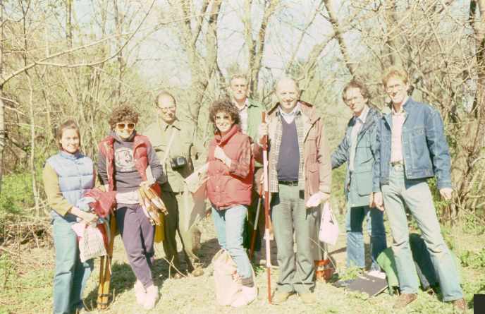
Attached is a photo of an archeological survey back in 1988 the KHS sponsored. Valerie DeCarlo is 2nd at left, next is author Michael Cohen, Fordham Univ professors Roger Wines and Alan Gilbert 3rd and 2nd at right and I’m the last at right.
Its not documented where Adriaen vander Donck (AVD) died but generally thought he was killed by Indians on his farm by natives from further up north. The local Indians having moved south to the city and those from upstate did not know vander donck. Its likely his wife was in their New Amsterdam house. If she was on the farm she too would have been killed or captured. We do know she soon remarried and sold the Patroon lands. Nick and I attended a book lecture few years ago in which the author of a new book on AVD stated he was killed at his farm house along with 2 mill workers. His farm home was located approx 50 ft south of todays Van Cortlandt mansion front door. My personal theory is that he was buried where the Kingsbridge Burial ground is located. The site being a burial site continued to be used as one by the Tippetts and Berian families who followed AVD aS owners of the lands and later used by the community. For those not familiar with vander Donck should know he was the first lawyer in New Netherlands and a foe of Pieter Stuyvesant . Two books of interest are 1) AVD own 1655 book on this area ‘A Description of New netherland’ and 2)Russell Shorto’s great book. ‘ Island in the Center of the World’ about AVD and New Netherlands.
Forgot to mention that the location of the dog run was the original location of the Ewen mansion show above. There is a black stump like rock nearer to the path that is a relic of the Ewen estate. It is actually a petrified tree remnant that was once used as a garden ornament on the Ewen estate.
Ewen Park provides one with an expansive view of Kingsbridge and Kingsbridge Heights. The park unfortunately is almost vertical which makes for great sleigh riding in winter and rolling down in summer. The only real flat section of the park, which was once the best location for picnics and such, was selected as the prime location for a city parks dog run. Go figure.
December 6, 2021 at 12:35 pm in reply to: Burying Tibbetts Brook – Construction and Chaos in Kingsbridge ca. 1900 #2395Interesting article but time will tell. Back in early 1990’s there was talk and effort for upgrading the old Putnam RR line for a walk and bike trail. Last year 25yrs later they finally blacktopped the old Putnam rail line trail. A bit earlier in mid 1980’s there was talk and community meetings for a Greenway trail along the Hudson River along Spuyten Duyvil and Riverdale. Last time I was down at the river, actually just last week, there is still no Greenway trail. This is not a knock against those who still work towards the Greenway trail, been there done that, but this is NYC. If the City administration and our elected officials want something it can happen and sometimes fast.
November 28, 2021 at 2:34 pm in reply to: Burying Tibbetts Brook – Construction and Chaos in Kingsbridge ca. 1900 #2382Hi Zach – just to clarify and give proper credit Nick provided the initial photos and created the changing map for this forum item.
The photo I attached of 234th St and Tibbetts brook is from the KHS photo collection. The photo(s) were donated to the Society in the 1960s by a family who lived in the area at the time.
The house in your photos at the bottom of the hill was at that time owned by the Ewen family whom the park today is named after. A larger Ewen home was located further up the hill on the only flat space in this hillside park that is today a dog run.
A word from the sponsor -The Kingsbridge Historical Society would greatly appreciate if anyone reading these forums and have photos or items to donate they would be greatly appreciated by the Society. Regarding photo’s digital copies are welcome if you would rather not donate the actual photos.
November 27, 2021 at 4:41 pm in reply to: Burying Tibbetts Brook – Construction and Chaos in Kingsbridge ca. 1900 #2379Great photos on the draining of Tibbetts brook tributary and raising of Broadway. Few additional facts that might be of interest.
1) The first photo mentions a church steeple. This was the original St Stephens church that was used from 1878 to 1898. The present day St Stephens was opened in 1898. It was for the 50th anniversary of the new St Stephens that the KHS founder (Rev Dr William Tieck) wrote his first book, “God’s House and the Old Kingsbridge Road”.
2) The changing map from old to new present day is a great visualization of our area, thanks Nick. I wanted to just point out that the Tibbetts Brook is at the left in blue on the map yet the photo’s of the twin drainage tunnels are on Broadway. What is not always known is that Kingsbridge was once known as the Island of Kingsbridge or native term Paparinemin. The Harlem River in the past use to flow north through today’s Target Shopping center and the Marble hill housing then it would flow west at 230th St and under the Kings Bridge, continue west to Riverdale Ave where it would meet up with Tibbetts Brook and both would flow south through today’s Kennedy H.S. school complex around the then Johnson foundry and west out to the Hudson River. But It was during high tide and rain storms that part of the Harlem River would also flow north along Broadway and meet Tibbetts Brook about 238th st which formed the Island of Kingsbridge.When not high tide or flooding the low lying area of Broadway was wet and swampy. It was due to this problem of tidal flooding that the twin drainage pipes were installed along Braodway to correct and create more usable land, drain the swamp like areas, rid the village of mosquitoes and set the stage for the right of way for the planned IRT subway. The Tibbetts Brook continued to flow as shown on the map to at least 1915 when Tibbetts too was slowly filled in and diverted into drainage pipes. Tibbetts Brook today still flows south from Van Cortlandt park south under Corlear and Tibbett Ave past 230th St and under Kennedy H.S. to meet the Harlem River and out to the Hudson all through buried drainage pipes.
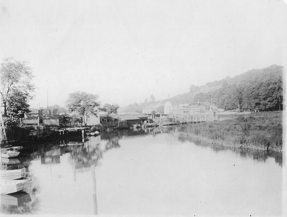
August 1910 234th St view south west with Tibbetts Brook
Interesting find never seen it before. The quality of the landscape drawing is well done and typical of the period. The foreground is a good rendition of Inwood. The house on the Spuyten Duyvil hill not too sure. I looks sort of like the Berrian house (later Berrian-Johnson house) with the porches and chimneys and number of floors. But it differs in the proportions as it looks too tall and an extra (middle) window in the gable end. Also the angle drawn on the hill looks be more SW facing rather than more southerly of the Berrian But the location would be about right. Perhaps the artist was better at landscape drawing than rendering architectural buildings. The De Rahm nursery new to me. But it might have been short live owners. Needs more research but good find.
In 1874 what is today the Western half of the Bronx, back then Lower Yonkers, Westchester County was annexed by NYC and became the 23rd and 24th Wards of New York City. The 23rd was the lower western half (Morrisania etc) while the 24th Ward included Kingsbrige,Spuyten Duyvil, Riverdale. As teh 23rd and 24th Wards were north of Manhattan they were referred to as the Great North Side. In 1898 NYC was consolidated and included the 5 boroughs we know today. The whole area we know today as The Bronx was created. Years ago there was a North Side Savings bank on w 231st north side of street just west of the Major Deegan who offered a commemorative plate depicting historic sites around Kingsbridge to people who opened a new account.
The Riverdale library and Neighborhood Assoc is the present day Riverdale Neighborhood House. It was founded in 1872 by Grace Dodge as a lending library for workers. Next year 2022 will celebrate 150 years.
September 25, 2021 at 9:09 pm in reply to: September 27, 1909 – Dedication of the Henry Hudson Memorial #2181Stephanie – thanks for providing the link to photo’s of the Mansion. There are some very interesting photos not seen before of the mansion and grounds.
September 25, 2021 at 7:02 pm in reply to: September 27, 1909 – Dedication of the Henry Hudson Memorial #2175Today it’s unfortunate that the view of the Henry Hudson Monument is obscured by the large Schervier apartment building. If one is driving north over the Henry Hudson Bridge it is very hard to see the monument. Back about 1994 the Muschenheim mansion (circa 1840) was still standing. It had a bronze historical plaque celebrating the fact that it built upon the American Revolutionary Fort #1 built in 1776.. But mysteriously the plaque was removed and a large bush was planted covering where the plaque once was mounted. When I asked the administrator of Schervier she had no idea what happened to the plaque. Funny how that happens. Then the old mansion was wrapped by building material. Again when asked I was told they were going to repair the roof and there was also an asbestos concern. Months later the oldest home in Spuyten Duyvil and perhaps Riverdale was torn down and the society was not allowed to do any archeological investigation of the site. Shades of the recent demise of Fort #2. Unfortunately historical preservation has little support or interest in Riverdale.
Losing the mansion was a big lost but worse still was the fact Federal funds were used to help build the new Schervier assisted elderly apartments and destroy the Revolutionary Fort site. The site of the mansion is today a parking lot. Shades of Joni Mitchell “Don’t it always seem to go, That you don’t know what you got ’til it’s gone, They paved paradise put up a parking lot”. Yes they did and the building today blocks the view of the Henry Hudson Monument. When I asked the then Community Board 8 chairman why the site was picked he was honest in stating they he had no idea that it would block the view of the monument. He apologized and wish they had better information when the building planning was discussed. Worst still was what I had found out later. The building was originally planned to be built further west. The land west of the present building slopes heavily downhill. If the building was built where it was originally planned it would not have interfered the view of the monument by not being directly behind the monument. But some in the community didn’t want the building down closer to Palisades and their homes. They had enough influence to have the building sited further east to Independence Ave. Where today it block a clear view of this historical monument.
Yes its the same Inwood Marble. Veins of it can be found in Riverdale. Have not read of it being quarried here but small quantities might have. But the real large deposits and quarries was found in upper Inwood/Marble Hill.
Scattered around the lime kilm above 232nd street at the parks edge over the RR tracks can be found large amounts scattered likely from the early lime manufacturing process.
There were large deposits east of the Riverdale ridge basically east of Broadway in the area what today is the Van Cortlandt parade grounds. It was the glacier action that wore down the soft Inwood Marble and gave us the Van Cortlandt Parade grounds we know today. The hard Bronx gneiss is what was left after the glaciers and form the Riverdale ridge and Van Cortlandt ridge where Vault Hill was built. The late Sydney Hornstein the geologist emeritus of the Mus of Nat History had a saying regarding our local rocks that “the Bronx is Gniess and Manhattan is full of Schist”.
It should be assumed in reading the above and other works that the term Kingsbridge Marble, Inwood Marble and Tuckahoe Marble can be and are used interchangeably. They are all basically the same rough large grained textured white marble. In the map above the actual site for the early marble quarry’s and mills was located where the black line runs across Marble Hill between the words Marble Quarry and Fort Prince Charles. Water was divetred from the Harlem River and using tidal actions to run the mills. The location is approximately the location today of the Harlem Ship canal. The Bolton brothers were one of the earliest to set up a marble quarry and mill. I should also be noted that the State Prison at Ossining aka Sing Sing was built by prisoners out of local Ossining Inwood Marble. Perhaps one could called it an early ‘green’ building project using local material and no carbon footprint.
The best source on the Marble Quarry at Kings Bridge was written by Lawrence N. Conklin in 1997. Years ago I had stopped in the rare gem store owned by Lawrence Conklin. I mentioned I was with the Kingsbridge Historical Society and he then set to telling me about his research and gave me a copy. Here is a link to his research titled ” Kingsbridge, and early quarrying district on Manhattan Island”.
If you were around when they built the new Allen Pavilion Hospital on Broadway south of 225th Street Bridge the digging of large footings for the new building exposed the white Inwood marble clearly visible from the IRT #1 train. If you have traveled in Yonkers on Central Avenue above and below Tuckahoe Rd you are passing the Tuckahoe marble quarries. You can view the quarry sites most on the west side of Central Ave above Tuckahoe Rd where the stores and shopping centers are set back in the property. Here on the Spuyten Duyvil and Riverdale Ridge over looking the Hudson there were important lime kiln’s remnants of one still extant. The Inwood marble was burned to create lime that was need to make cement and used to build many early building in old New York. This was a very early manufacturing process in the area using raw materials for the building industry.
July 13, 2021 at 6:27 am in reply to: Grateful Dead, Black Sabbath, Jefferson Airplane, Yes — Gaelic Park in 1971 #2060Went to a Young Rascals concert likely 1971. Concert starter off on a sour note. The bands agent comes out and stated that if anyone comes up to the stage or tries to come onto the stage the band was going to leave. The noise of the boo’s was louder than any music heard that night. The Rascals were a big name band but they weren’t the Stones or Beatles for them to make such an announcement.
From John McNamara’s History in Asphalt :
Finnerganville small settlement on eastern slope of W 246th st from Riverdale Ave to Broadway.
Irish Town settlement of 19th Century at West 258th St and Riverdale Ave – also aka Coogan’s Alley. Today dead end street with a number of old private homes from that period.
Interesting connection and find regarding Calder here in Spuyten Duyvil. Anyone who took the Revolutionary tour last month saw the site of the Edgehill Inn. The house was built on the location of Fort No. 1 . Initially it was the Sage Mansion which later became the Edgehill Inn. The location was on the east side of Arlington Ave midway between 230th St and 225th St where the 4-5 private house today are set back on their lots.
Attached is a small piece on Calder from Wikipedia. Looks like he was here from 1912 to 1915. So looks like his family was pretty ‘mobile’ and he ‘hung’ around here for only 4 years ( yes puns intended).
from Wikipedia :
In late 1909 the family returned to Philadelphia, where Calder briefly attended Germantown Academy, then they moved to Croton-on-Hudson, New York.[11] That Christmas, he sculpted a dog and a duck out of sheet brass as gifts for his parents. The sculptures are three-dimensional and the duck is kinetic because it rocks when gently tapped. In Croton, during his high school years, Calder was befriended by his father’s painter friend Everett Shinn with whom he built a gravity-powered system of mechanical trains. Calder described it, “We ran the train on wooden rails held by spikes; a chunk of iron racing down the incline speeded the cars. We even lit up some cars with candle lights”. After Croton, the Calders moved to Spuyten Duyvil to be closer to New York City, where Stirling Calder rented a studio. While living in Spuyten Duyvil, Calder attended high school in nearby Yonkers. In 1912, Calder’s father was appointed acting chief of the Department of Sculpture of the Panama–Pacific International Exposition in San Francisco, California, and began work on sculptures for the exposition that was held in 1915.
During Calder’s high school years (1912–1915), the family moved back and forth between New York and California. In each new location, Calder’s parents reserved cellar space as a studio for their son. Near the end of this period, Calder stayed with friends in California while his parents moved back to New York, so that he could graduate from Lowell High School in San Francisco.[15] Calder graduated with the class of 1915
For the definitive answer you need to speak to Tom Bird when you get a chance. Tom was the driving force in getting the city and Park to purchase the U Thant estate and make it a park adjacent to Seton Park. I was on the Arms Around the Park committee and group that Tom started to save the strip of land from developers. My understanding is the U Thant house was located on this parcel of land. The entrance is noted by the two large stone columns you see on Palisades north of 232nd St.
Our political leaders at the time waffled (what else) on whether to support the land becoming a park or letting the developer build on it. The Boro Pres. then Freddy Ferrer, was for it before he was against it then was for it and it finally became part of our parks. Why Wallenberg Forrest I don’t remember. No one I know called it or calls it Wallenberg Forest. That is just another stupid name Parks Comm. Henry Stern decided on. Much like he gave silly names to NYC Park workers like they were horse or servants who had to wear the idiot name tag he made up.
Why not U Thant? He lived there and was Sec General of the U.N. but had no real connection to Riverdale or the Bronx.
Could have been worse if it Kurt Waldheim who lived here. Imagine having the park named for him.
Why Raoul Wallenberg? Again best to speak with Tom Bird. What I remember that about this time there were news articles that Wallenberg might still be alive in Russia. Russians stated he died soon after the war after he was imprisoned by Russia. Also some belongings were returned of his and there was articles of sightings of him in Russian prisons years after the Russians said he was dead. Many places around the world were naming sites for him and believe this is how Raoul Wallenberg’s name was used for the park.
Again all credit for saving the property as a City park goes to the effort of Tom Bird who was able to get our politicians, and community rallying around the idea to save the land from developers.
I agree Robert Caro’s The Power Broker will answer many of the issues your researching. Like the biblical Moses, Robert Moses parted Inwood Hill Park, Riverdale and Van Cortlandt Park with the Henry Hudson Parkway and is covered in the book.
Filtration plant was a polictical decision supported by the then mayor Bloomberg and trade unions. There was a location perfectly located in North White Plains that the Westchester community actually wanted the filtration plant.
Much of what you seeking can be found searching the internet. The link that Nick included has much info.
Another is this one https://www.nycgovparks.org/about/history/timeline/park-planning-for-greater-ny
The local Riverdale Press news paper has had many articles over the years covering some of these issues.
NYC parks do not have as much protection as everyone would believe. The Parks Dept is not supported financially as they had been a generation ago. Now they get operational funds for minimal maintenance and look for handouts from private sponsors who will pay for improvements.
Good luck with your research. The society would appreciate a copy ofrlink to whatever you publish.
March 26, 2021 at 4:11 am in reply to: Developments in Kingsbridge – Corlear, Godwin, Broadway #1915The more things change the more they stay the same as the old saying goes. The Kingsbridge sewer project 120 years ago sounds much like the Con Ed gas main replacement here in Riverdale and Kingsbridge and the Bronx. Con Ed contractors were over 2 years working on my block alone and they still have many surrounding streets to complete and more still to start. They started back in March 2018.
But of more interest is the price of the Kingsbridge sewer project started in 1899 for a contracted price of $804 Million dollars ! This was a enormous amount of money in 1899. To put into perspective how large the 1899 sewer project cost in present day dollars in 2021 calculating with inflation it equates to over $25 BILLION DOLLARS. A drain on any budget then or now.
Very interesting photo and park house/shelter, never seen it before. The initial photo shows what appears to be Tibbett’s brook flowing East of the house. The photo showing the rear of the house looks to be taken from a hill south of the house. So my guess is that when they dug the storm /sewer drain to drain and hide Tibbetts Brook this house was likely in the way and removed. What appears to be a hill south of the house where photo was taken was also likely removed or leveled to grade was we know today. Later in the mid-1930’s Robert Moses built the stadium and 36 tennis courts on West side of the new stadium in about the location of the park house (shelter) in question. Again just a possible scenario of events and very interesting photos.
On first map at top with North being to the right the large BLACK DOT near words Broadway looks to me to be the comfort station. The F.A. is a circle colored purple looks to be to be the same comfort station in nexy 2 maps. Note the bathroom/comfort station east of the museum is same color.
The building in question in the first map on the East side of street has an S with a line denoting south I believe. I would assume it is the train station and the “not open yet” is the overpass connection uptown and downtown that perhaps was not open yet for use. Or they used an older map and did not update it.
The photo looks to be dated 1925. Would help to know the dates of the 3 maps as they look to be different years and perhaps makers hence the confusion.
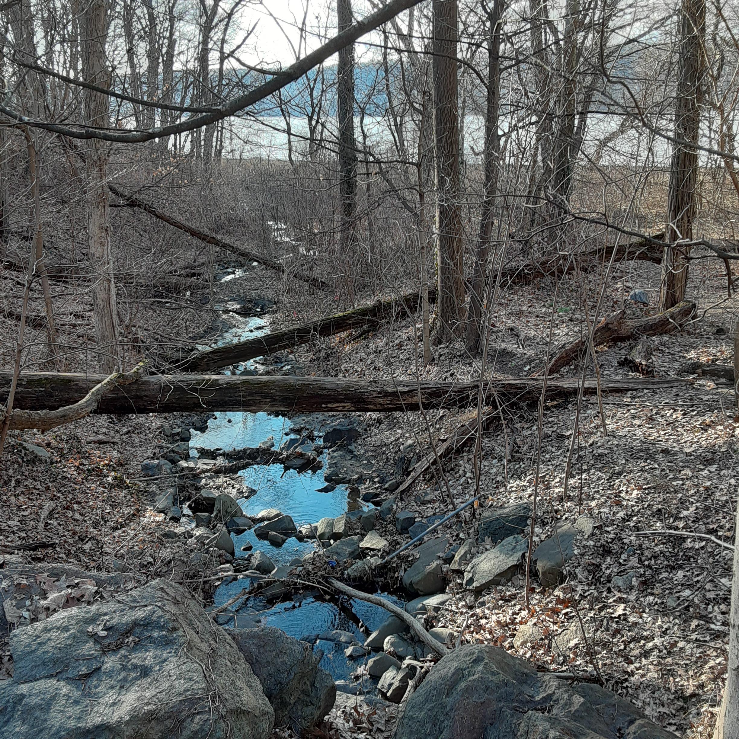
Adler Brook yesterday Jan 18 2021
south of Wave Hill looking East with waterfall
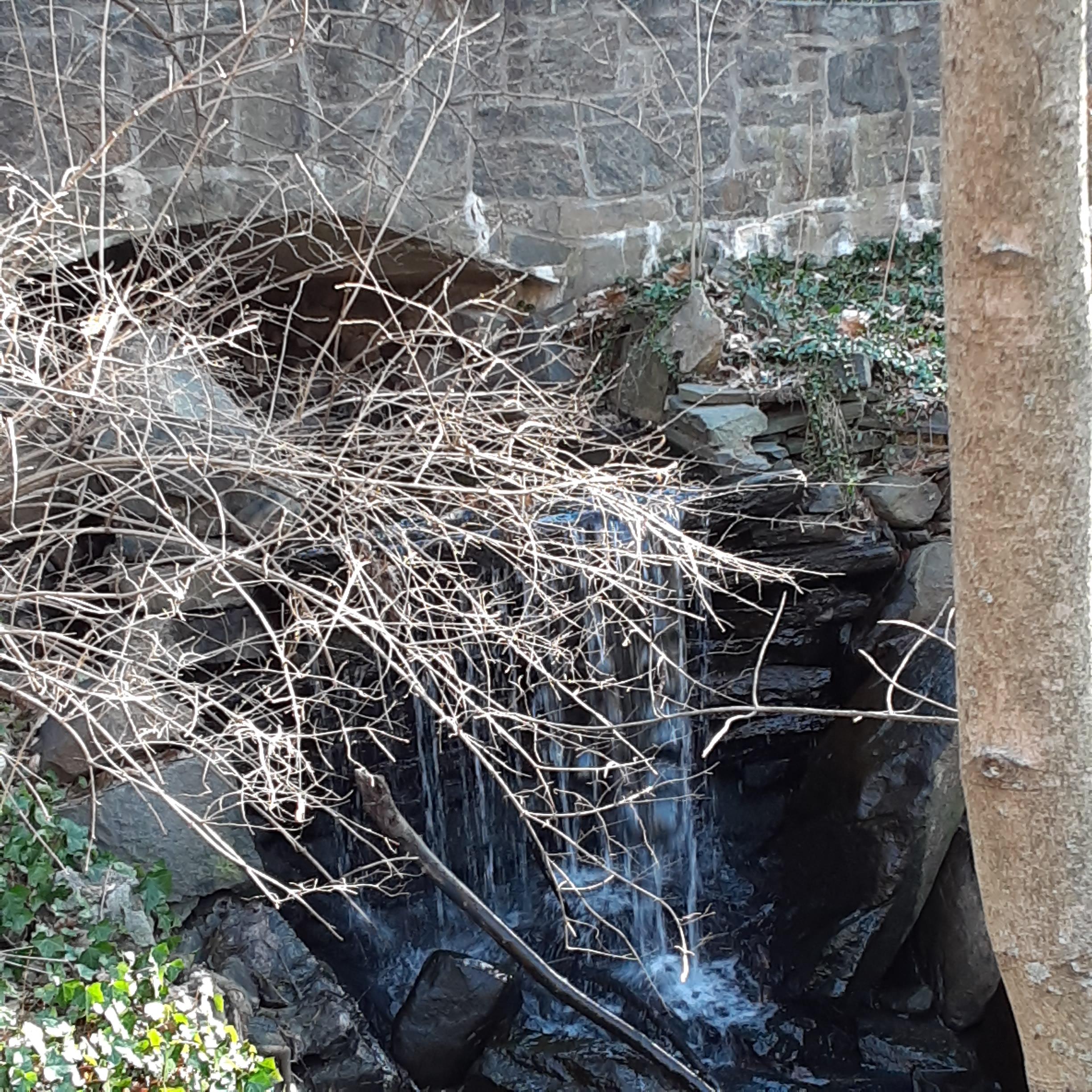
Adler Brook flowing west to the Hudson River
-
AuthorPosts