Forum Replies Created
-
AuthorPosts
-
In a sense I agree that Frederick Philipse was not a “lord” as we tend to think of it. He was certainly no member of the nobility. And you are right of course that he obtained much of his wealth by marrying into money.
But he also was not merely a very rich guy who owned a lot of land and a bridge. And for those who do not know, he owned a large chunk of Kingsbridge and Riverdale including the Kingsbridge, which was the first bridge to Manhattan. He acquired his lands in our area in many separate purchases, which are recorded in ordinary deeds. Then, in 1693, his lands were declared to be “the Manor or Lordship of Philipsburg” in the charter that was issued in the name of King William and Queen Mary. Here is the preamble:
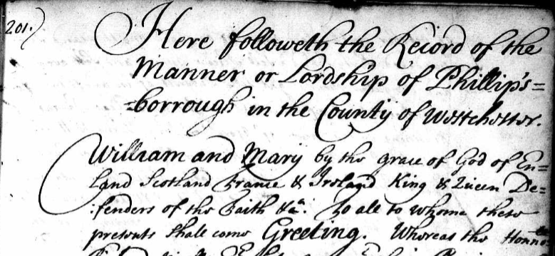
So what made his property a “Manor” or a “Lordship” as opposed to merely an estate? The charter gave him special rights as a lord that no regular property holder had.
One of those was the right to hold Court Baron and Court Leet in the Manor of Philipsburg. The rights to hold these courts go back to the medieval traditions of England and they were only granted to lords of manors. Here is the relevant section of the charter (transcription below):
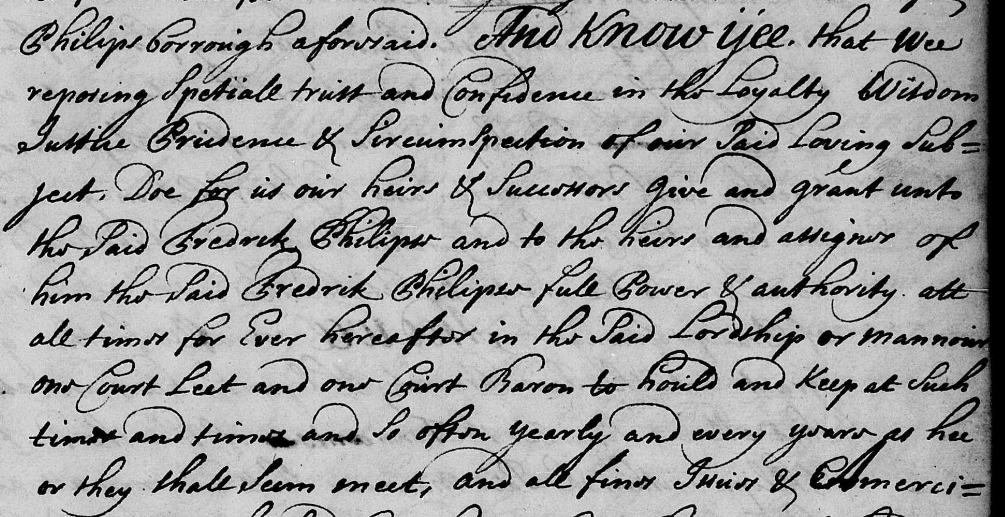
Transcription:
And know yee that wee [King William and Queen Mary] . . . grant unto the said Frederick Philipse and to the heirs and asigns of him the said Frederick Philipse full power and authority att all times for ever hereafter in the said Lordship or Manor one Court Leet and one Court Baron
Another special right that he received in the charter was that of an advowson and patronage to the churches that he would build in his manor. This meant that he could essentially appoint whomever he wanted to serve as the local clergy on the manor. This was a right that gave a lord special influence over his tenants:
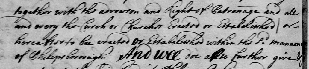
…together with the advowson and right of patronage and all and every the churches erected or established or hereafter to be erected or established within the said Manor of Philipsburg
Certain other rights like the right to charge a toll at the King’s Bridge and the right to appoint assessors were also included in the charter, which was signed by the governor of New York Colony, Benjamin Fletcher. So, in a legal sense he was given the rights of a lord, which is why Frederick Philipse and his heirs are commonly referred to as the “Lords of Philipsburg Manor:”
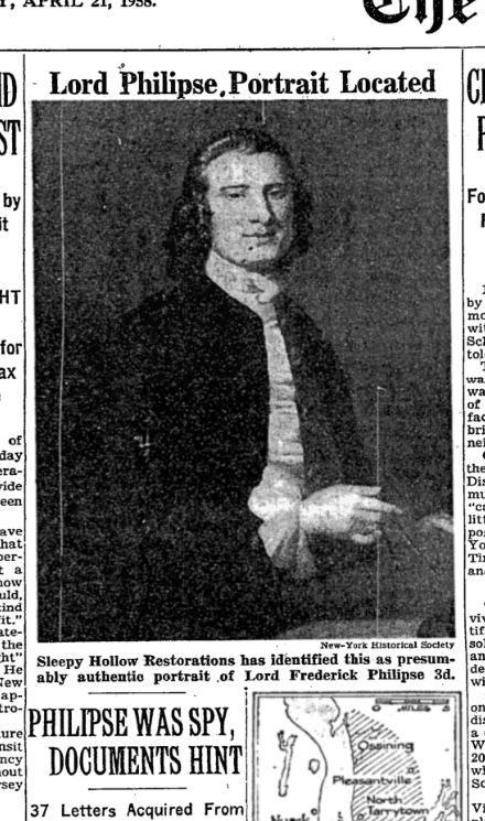
One thing that is strange though is that I don’t ever recall seeing Philipse referred to as a “Lord” in original 17th century documents. Only after the American Revolution do I come across documents referring to the Philipses as “Lords.” This leads me to believe that perhaps Americans started to refer to them as “Lords” as a way of identifying them as the enemy since the Philipse family stayed loyal to King George III during the Revolution. There is no indication that Philipse was particularly cruel or hard on his tenant farmers in Philipsburg. In fact, he charged pretty cheap rent! But it is still wild to think that Kingsbridge and Riverdale once had a “Lord” if only in a legal sense.
As you know, Tom, Riverdale, Kingsbridge, and Spuyten Duyvil were parts of Yonkers until the end of 1872. Most of historic Yonkers was part of Philipsburg Manor, the 52,000 acre estate of Lord Frederick Philipse, which stretched from Riverdale to the Croton River. I think our area may have been called “Little Yonkers” to distinguish it from the larger portion of Yonkers that was included in Philipsburg Manor. But I have only seen the term “Little Yonkers” used in a few documents and it does not seem to have been an official name.
Bingo, that’s it. Congrats to all of those who helped figure it out. The North Side Savings Bank gave away these plates at the bank’s opening on December 1, 1951. Here are a few closeups of the scenes depicted on the plate:
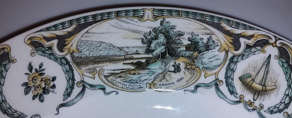
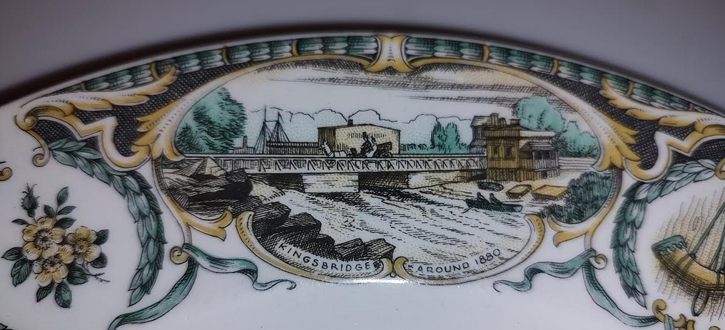
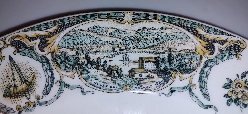
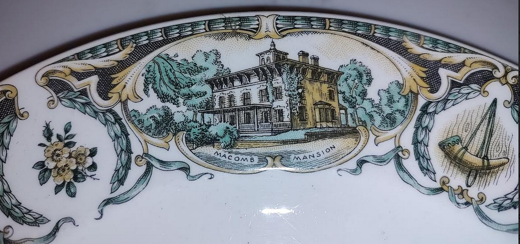
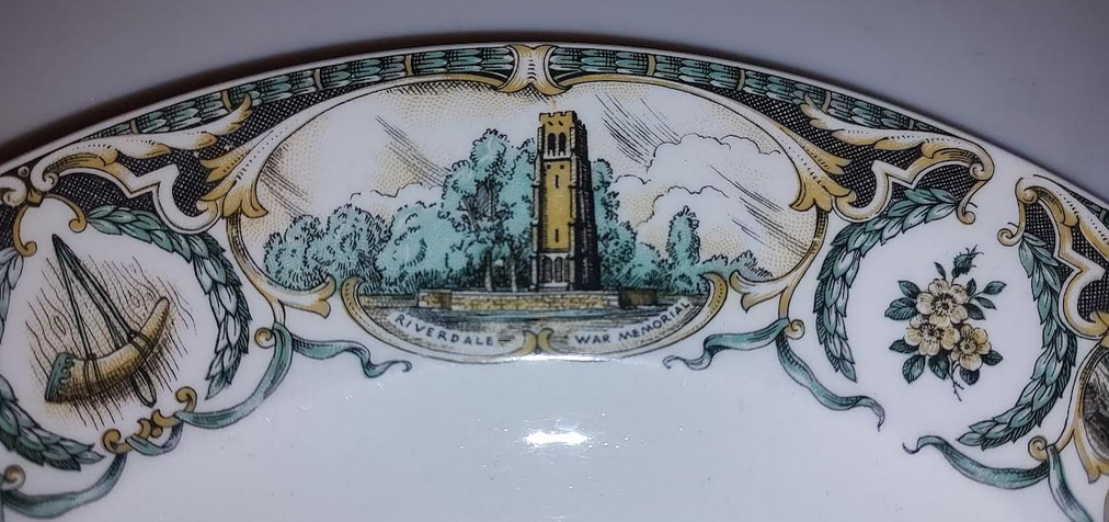
The newly formed Kingsbridge Historical Society played a role in selecting imagery for the plate, which you can still find on eBay for a resonable sum.
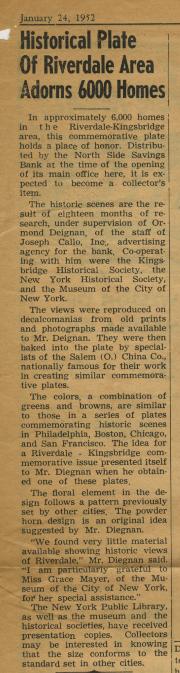
The film clip comes from a 8mm film reel in our collection. I was very excited to see it as it harkens back to the early days of the KHS and it shows the neighborhood in color. I can’t wait to show the film in its entirety at a future KHS event, possibly in the spring. The film depicts a number of events that would be difficult to understand without the help of the Riverdale Press as a historical record from the time period. I think it would be fun to show the film and explain it using RP articles. This is the clipping in our collection that explains the mystery scene:
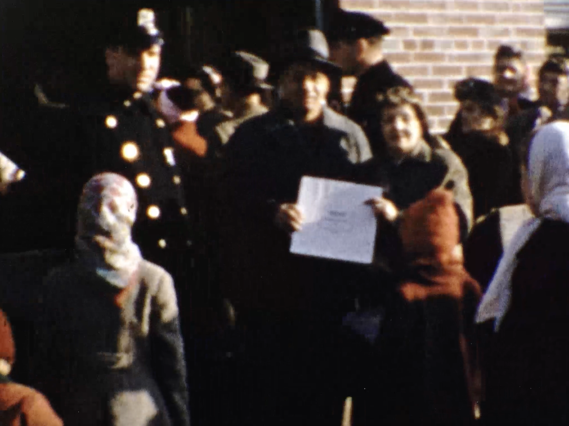
Okay, here’s a little hint. They were indeed giving something away at the bank opening–but not toasters nor copies of the Declaration of Independence. The line to the bank went around the block to get this free giveaway and 6,000 of them were handed out to local residents. Here is a screen shot from later in the film showing a patron who just walked out of Northside Bank with one of the mystery items. Can you figure out what it is?
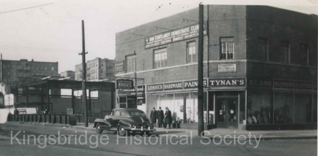
That is the building and that was indeed the occasion–the opening of Northside Savings Bank on West 231st Street in December of 1951. This film was shot before the construction of the Major Deegan Expressway so there are a number of buildings at the end of the clip that were torn down during its construction. Below is a photo from our archives of the bank building under construction on the left and Tynan’s hardware and Robert’s Books on the right:
By the way, there was a reason why so many people were lined up for the opening of this bank (and it wasn’t the savings account interest rate). Does anyone know why the opening was so well attended?
Yeah, I imagine that is a pretty rare postcard.
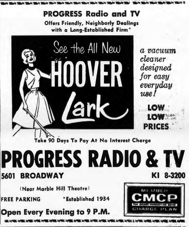
Nice anecdote about watching the inauguration of Queen Elizabeth on a Hoffman! Speaking of the Riverdale Press, I found this ad in a 1951 issue of the Riverdale Press indicating that Progress Radio had been in business since 1934:
Here is an example of one of Riverdale’s lime kilns (photo taken from William Tieck’s Riverdale Kingsbridge Spuyten Duyvil on p. 104).:
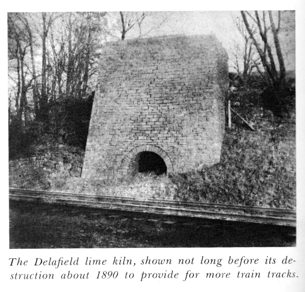 It is an example of one of the earliest forms of industry in this area.
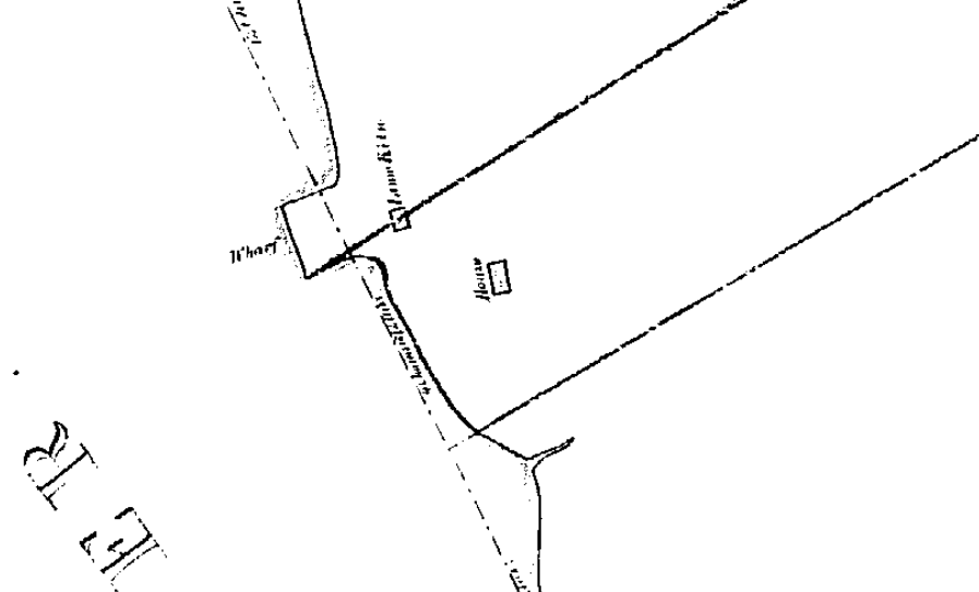
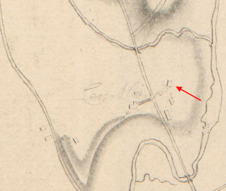
That’s an interesting point, Tom. There was a lime kiln right in that area and oyster shells can be burned to produce lime mortar. Below is a snippet from an 1840 property map depicting that section of Riverdale Park. Note the “Lime Kiln” just next to the wharf. The line traversing the kiln is the property line between Samuel Thomson and William C. Wetmore. The line just to the south is the property line between William C. Wetmore and James R. Whiting. So the structure labeled “house” would have belonged to William C. Wetmore.
If you check out the link that Buddy sent, you can get to this archaeological report. In the report conclusion, they wrote:
Located at the extreme south of the park, on a heavily eroded, steep-sided promontory, Site One is an area of extensive oyster shell covering approximately 4,30 square feet…
The recovery of industrical slag, coking fuel, wire nails, broken beer bottles, rifle shells, and a railroad spike has been attributed to the Euroamerican component. Rothschild and Fenton believe the relative scarcity of these artifacts, though, seems to indicate intermittent use as a dumping ground and recreational area during the nineteenth- and twentieth-centuries.
The prehistoric component is represented by a large amount of oyster shell which has been interpreted as the remains of aboriginal foraging activity. Additionally, Rosthschild and Fenton believe that the varying densities of shell suggests many occupational episodes over a number of years, rather than a single, continuous occupation.
The archaeologists also found the lime kiln (even though they did not know about the above map) but they never connected the oyster shells to the kiln. Another substance that was burned in lime kilns was limestone marble. It just so happens that the bedrock in that part of Riverdale Park is Inwood Marble. Perhaps the marble was used as a raw material as opposed to the oyster shells. We will be disscussing some of these questions with the geologist on our October 14th hike.
There is so much late 19th/early 20th century junk in that park beneath the surface that I wonder if it was used as a dump at some time. In Van Cortlandt Park trash was dumped in various swamps to raise the ground level. I wonder if something similar was done in Riverdale Park, possibly to fill in an old quarry. Or perhaps the neighborhood just needed a garbage dump and this was the location.
Yeah, I was going to put that in another thread about JR Whiting and Seton Park but that’s the photo. There are links to a bunch of photos of that area here.
Only after reading your posts and seeing those photos of Seton Park in the 40’s and 50’s was I able to figure out that JR Whiting’s house was photographed and looked like this:

What a behemoth! That photo is from 1956. It is hard for me to believe that it stood in the fields of today’s Seton Park until the late 1950’s. Perhaps it began as the smaller house drawn by Edwin Whitefield and was later expanded by Whiting’s son, JR Whiting, Jr. Whiting’s former mansion is not the building we usually associate with Seton Hospital but it was part of the Seton Hospital complex, which had separate buildings for women, men, and children.
Thanks for the posts, Peter and Tom. They got me curious and digging around for more information on the JR Whiting estate, Seton Park, and Seton Hospital. Since it is a slightly different topic, I will post those findings in a new thread later.
But I think I figured out the stone pillars on Palisades Ave. After 1840, J.R. Whiting’s estate was between W. 232nd and W. 235th Streets (as are the stone pillars). However, the pillars flank a driveway that headed north of the Whiting estate past 235th Street to a lot between 235th and 236th Street in today’s Raoul Wallenberg Forest. That is the old U Thant property (although I do not know who lived there before Thant). Here is a marked up 1921 Bromley Map:

The NYS Archives has a 1948 aerial photo taken from a plane over the Hudson River looking towards this section of Spuyten Duyvil and it correlates with the map.

Here is a closeup of the pillars:

Back to the Hudson River Houses… Apparently, the last sketch that Edwin Whitefield made of a home in our area was this one:

The caption in the book: “Unidentified house, probably in Riverdale, the Bronx. Date and architect unknown.” I wonder whose home this was.
That makes sense, Tom. If you look at the drawing of Whiting’s estate house, you can see that it is at the edge of a slope like your map shows.
Another local home that Edwin Whitefield drew still stands today on the campus of the College of Mt. Saint Vincent–Edwin Forrest’s Fonthill Castle:


It was a newly built when Whitefield made the above sketch.
The building I was most excited to see depicted was “Major Jos. Delafield’s Lodge at Fieldstone Farm, Yonkers.”

Correct me if I’m wrong, but I believe this building still stands at 6 Ploughman’s Bush in Riverdale. This sketch shows what it looked like before it was expanded in 1877.
Thanks for the info and book recommendations.
Whitefield’s book included a drawing of another Victorian house that I had never seen before, that of R.H. Nevins:

Just Googling the name does not turn up much but Nevins was a director and treasurer of the Stuyvesant Institute. His house, “Riverside” was located in today’s Riverdale Park southwest of Wave Hill, which was a smaller structure owned by William Lewis Morris at the time:

Another home drawn by Whitefield belonged to James E. Bettner:

I could not find much on Bettner either but his home was located at the southern end of the Hebrew Home property:

These were the early days of Riverdale, before the word “Riverdale” even shows up on the map. Amazing to see the size of the estates–some in the hundreds of acres.
August 8, 2023 at 3:06 pm in reply to: Proposed 34,000 seat Cricket stadium for VC Park Parade Grounds #3547The New York Times published an article today about the proposed cricket stadium in Van Cortlandt Park: https://www.nytimes.com/2023/08/08/nyregion/cricket-stadium-bronx-adams.html
The article mainly dealt with complaints from cricket players but it did attempt to delve into the history of the park. The journalist was thrown off by a sign in the park and got some facts wrong so I wrote the following request for a correction:
Greetings, New York Times.
I am writing to report an error in this article: https://www.nytimes.com/2023/08/08/nyregion/cricket-stadium-bronx-adams.html
The article states: “A historical sign for the park notes that in 1655, a Lenape woman tried to steal a peach from a farm there belonging to Henry Van Dyck. Mr. Van Dyck shot her.”
The historical sign does not state that Henry Van Dyck resided within today’s park and there are no historical records indicating that he did. Although, admittedly the park sign is confusing.
Secondly, all recent scholarship suggests that the hostilities of 1655 did not result from the theft of a peach. The attack on New Netherland is largely seen as an act of revenge by the Susquehannock people, who were allies with New Netherland’s rival, New Sweden. After the Dutch conquered New Sweden, the Susquehannock attacked New Netherland as an act of reprisal. See Russell Shorto’s “Island at the Center of the World” for more information.
Best regards,
Nick Dembowski
July 21, 2023 at 11:40 am in reply to: Proposed 34,000 seat Cricket stadium for VC Park Parade Grounds #3545At this point, there are so many unknowns that it is impossible to understand how the stadium would affect the museum or the park.
July 20, 2023 at 5:05 pm in reply to: Proposed 34,000 seat Cricket stadium for VC Park Parade Grounds #3541I am curious if the stadium construction will require any digging. If yes, it should trigger a review, which could result in archaeology. In my opinion, it should.
If the depiction in the figure below is accurate, the stadium would sit on the eastern edge of a historic indigenous village site. When J.B. James excavated the site in 1890, he recovered many Native American artifacts, which are now in the Smithsonian. Additionally, he uncovered a dozen human burials there and those remains are in the Museum of Natural History.
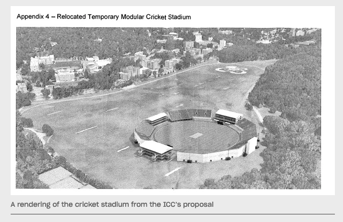
Later the field became the planting field of the first European colonist in the area, Adriaen van der Donck. His settlement ended in an apparent massacre in 1655. Then it became the planting field of the Van Cortlandt plantation. During the Revolution, there were structures in the vicinity of the proposed stadium site as indicated by this British intelligence map.
The stadium would seem to sit right where the few buildings are located on the right side of the above map clipping. I believe that could have been the home of Isaac Low, who was one of New York’s delegates to the Continental Congress. If I am correct, that is where George Washington penned this letter when he was evacuating his troops from NYC in 1776. If I recall correctly, that is also the approximate location of the Van Cortlandt apple orchard, where the Continental Army encamped in July of 1781. And, as Peter noted, it is very close to the Kingsbridge and Enslaved African Burial Grounds.
So, yeah, it is a very historic area. I am eager to see what is said at tonight’s community board meeting at 7.
Thank you, Julie. I think it is wonderful that the New York City Landmarks Preservation Commission’s Archaeological Repository is preserving and cataloguing these artifacts. This Delft tile stood out to me:
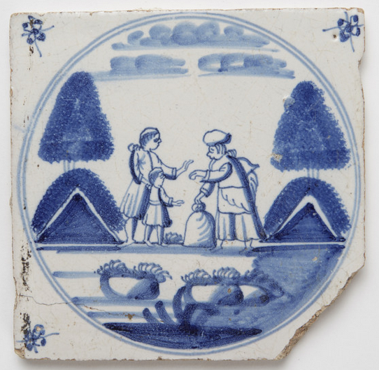
It was excavated from a pit of 19th century garbage but we have that exact tile in the Van Cortlandt House Museum flanking one of the fire places. I think this one may have been thrown out by the Van Cortlandts in the mid 1800s because it was damaged.
It would be great to know the whereabouts of the artifacts from the excavations conducted in the early 20th century. That’s when they were converting the Van Cortlandt estate into a park so there was a whole lot of digging. When you read old histories, they wrote about finding amazing stuff but no one knows where any of it went!
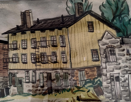
The photos Alan found of the three buildings from the watercolor are pretty great. This was the photo where I first found the buildings:
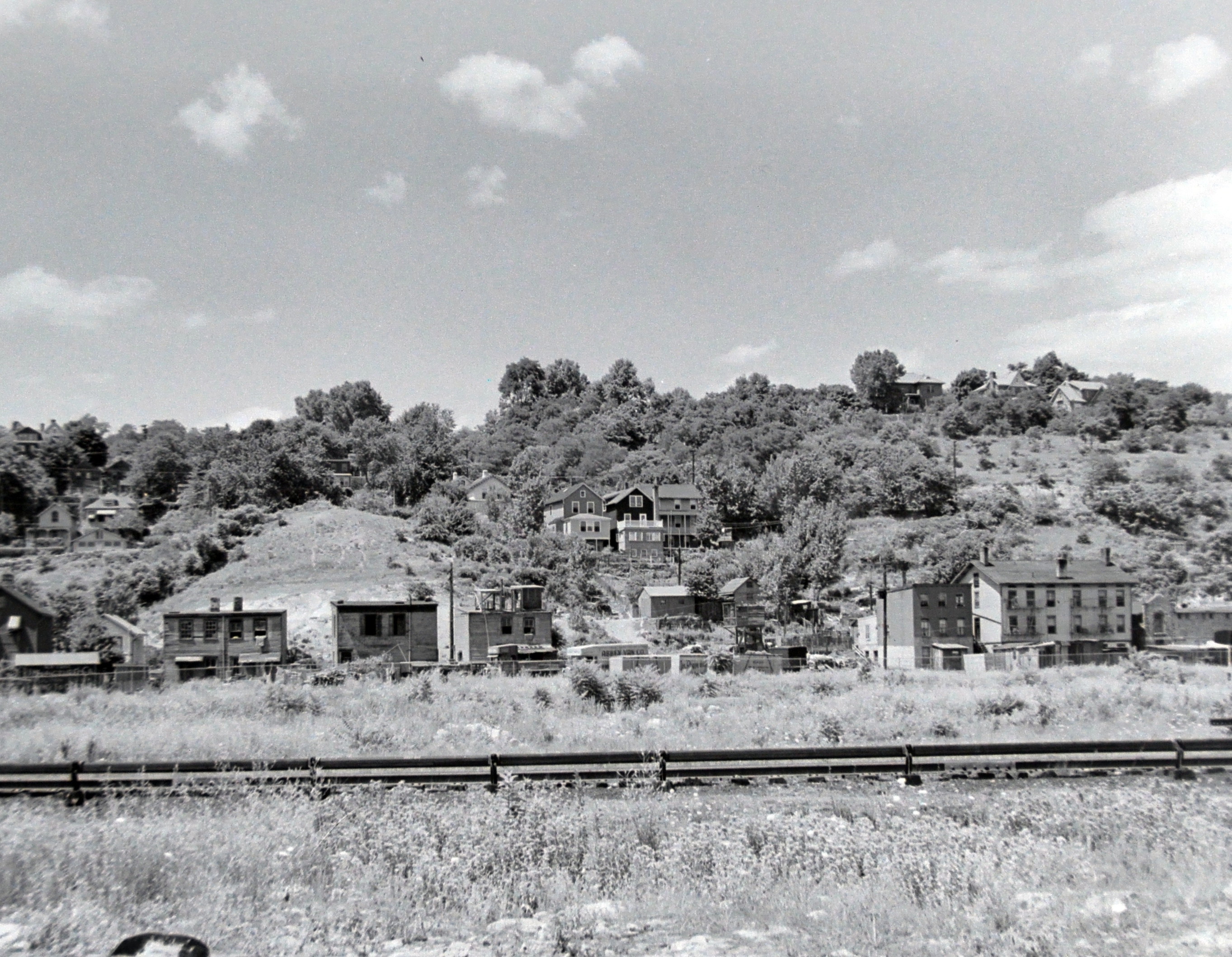
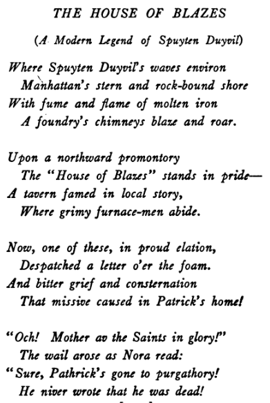
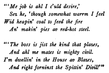
The three buildings from the painting are on the right. This view is looking to the northwest at Spuyten Duyvil Hill in 1939 as if you were standing on the JFK High School athletic fields today. These buildings were part of the old “mill town” of Spuyten Duyvil, which no longer exists. The “mill” was the rolling steel mill of Isaac G. Johnson at Spuyten Duyvil, which employed many immigrant laborers. The large yellow building in the watercolor was the legendary House of Blazes. It was known as Spuyten Duyvil’s “house of ill repute.”
The House of Blazes was the inspiration for this poem by Arthur Guiterman:
When the author Theodore Dreiser lived on Marble Hill, he described the view of the mill town as in the photo above as being “occupied by a range of low, yellow, wooden tenements, the homes of a number of foreign workmen, who were employed in the steel mills beyond, and back of them again was the bank of a huge hill which towered like a leviathan above them. They were so homely, the little tenements of yellow. They snuggled so humbly between the green wall of earth and the hurrying current of the river. They looked by day like some brown patchwork left over from a preceding autumn of glorious color and by night like some jewel-studed stuff of velvet, or some wall of ebony set with diamonds. High overhead, above the crest of the hilltop shone the stars, and far below lay the water, gleaming and twinkling with rays which the tenements cast. I remember looking with a soulful, heartfelt awe upon the beauty of the scene and wondering whether I should ever be able to describe it and whether I could ever make anyone feel what I was then feeling.”
A couple of hints:
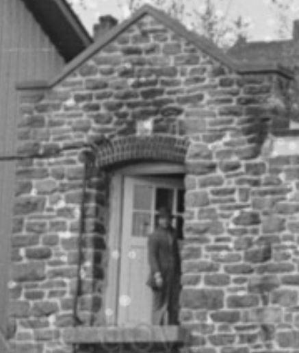
The yellow building in center was described as “legendary” by the Rev. William Tieck.
A photo clipping of the building on the right:
It does look something like Macomb’s mill at the King’s Bridge but that is not the building featured in the watercolor.
The buildings in the watercolor are depicted in a photo on the website, although not too clearly.
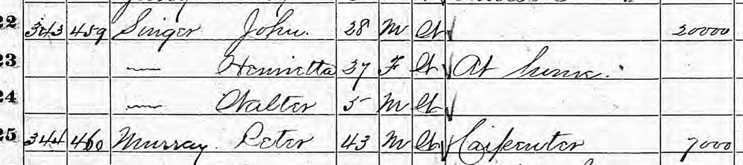
Good sleuthing Tom. And Peter, you are right of course that if you were living in the valley of Kingsbridge you would not have a “magnificent panorama” of the Harlem and Hudson Rivers. That must be an error. This 1868 map of Yonkers (Kingsbridge was still part of Yonkers at the time) shows the Singer property between Corlear and Kingsbridge Ave that you found a record of, Tom. It is in the center of the clipping below:
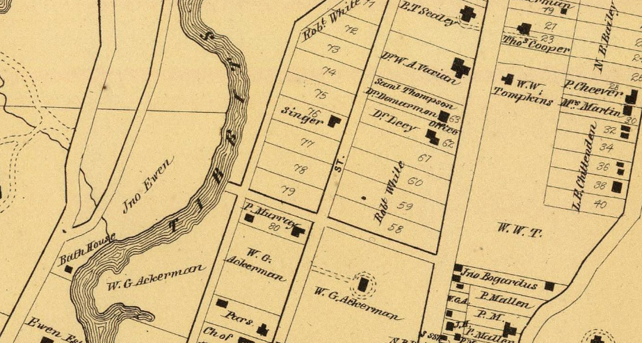
This map was made four years after Isaac Merritt Singer purchased property in today’s downtown Yonkers so one could assume he was no longer living in Kingsbridge. So who was living in the Kingsbridge “Singer” house at the time this map was made? That would have been Isaac’s son, John Singer, his wife Henrietta, and their son, Walter. The 1870 census of Yonkers lists them just above their neighbor, Peter Murray. The singer property was probably pretty nice to be valued at $20,000, a large sum in those days. Also interesting that John Singer had no occupation listed.
They would have had a nice panorama of Tibbetts Brook to the west and the nearby salt marshes but Spuyten Duyvil Hill blocked the view of the Hudson.
The 1873 patent for chest protectors that you found is pretty cool, Tom. That was the year that Kingsbridge declared independence from Yonkers and one year before it joined NYC, which is probably why it says “Isaac A. Singer of Kingsbridge.”
Thanks for sharing that great map, Julie. The tennis club you identified was the site of the 1911 Davis Cup tournament, a pretty big deal in the world of tennis.
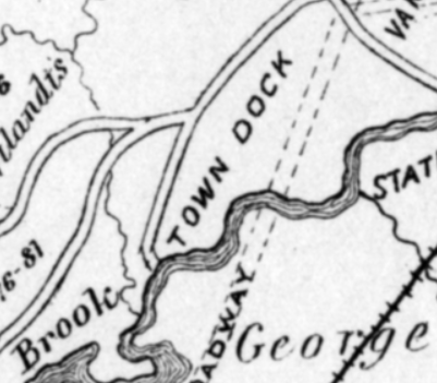
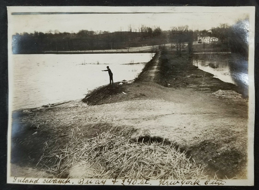
That area west of Broadway at W. 240th Street (about where Gaelic Park is today) was the location of the town dock. It is hard to believe at this point because there is no water in sight but the photo shows just how vast the marsh really was. The map you posted indicates a lane coming south from W. 242 toward Tibbetts Brook:
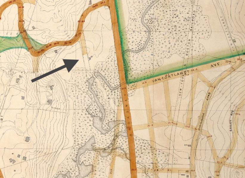
This 1909 property map depicts that road and labels it as “Free Landing Road.”
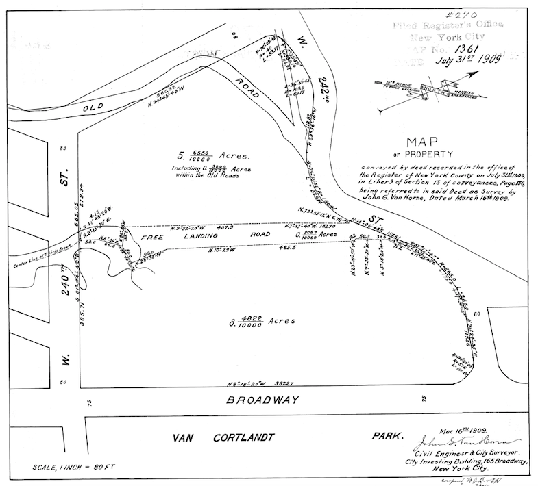
The term “landing” indicates the presence of a docking place for boats and Thomas Henry Edsall’s Historic Sketchmap of Kingsbridge labels it that way:
Colonial-period land deeds refer to it as the “Stony Brook Landing” as the little stream that fed into Tibbetts Brook from the hill to the west was known called Stony Brook. That stream still exists but it is fed into the sewer system at Brust Park across the street from Manhattan College.
This was a good find, Stephanie. If Wright had his way, it would have completely changed the area.
So you think this could be looking east instead of west? I wish I could get a blown up version of the photo but it is not available. But I see what you are saying. There does appear to be a very flat dark line along the bank of the swamp in the distance that could be the Putnam railroad. Do you think you know what date these photos were taken? If yes, we could cross check it against a map from that year. This is after the Broadway elevated line was put in so has to be after 1908.
Hi Stephanie. Just FYI, there is an issue with the forum notifications that I’m trying to resolve. So, some of our members (including me) aren’t getting notified of new posts.
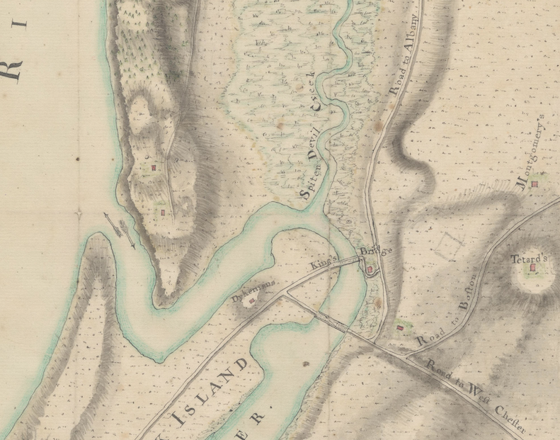
As regards Tetard’s Hill, it refers to the homesite of J.P. Tetard, who lived in today’s Kingsbridge Heights, not Spuyten Duyvil. He ran a French language boarding school in modern Kingsbridge Heights during the colonial period and he was a chaplain in the American Revolution. The founder of the KHS, the Rev. William Tieck, wrote a book about him called America’s Debt to John Peter Tetard. Tetard’s farm was in the vicinity of John Archer’s Fordham Manor settlement, which dates to the 1660s. At that time, I know of no colonial settlers living on Spuyten Duyvil Hill.
On some Revolutionary-era maps, Tippett’s Hill (a.k.a. Spuyten Duyvil Hill) was sometimes mislabled as “Tetard’s Hill” leading to some confusion.
Below is a clipping from a Revolutionary period map showing the correct location of Tetard’s Hill in Kingsbridge Heights on the far right. The map is held at the William Clement Library at the University of Michigan.
-
AuthorPosts