Forum Replies Created
-
AuthorPosts
-
August 27, 2021 at 12:54 pm in reply to: Brooks and Streams Criss-Crossed Riverdale in Days Gone By – Harry Emery #2135
Ah, yes good point. It is an 1879 George Bromley map and this link takes you to the version with details. Curious to see how much of the land that comprises the Mosholu Golf Course was owned by individuals not named Van Cortlandt.
August 27, 2021 at 11:44 am in reply to: Brooks and Streams Criss-Crossed Riverdale in Days Gone By – Harry Emery #2133Quite a number of the listed above streams can be found on this map:
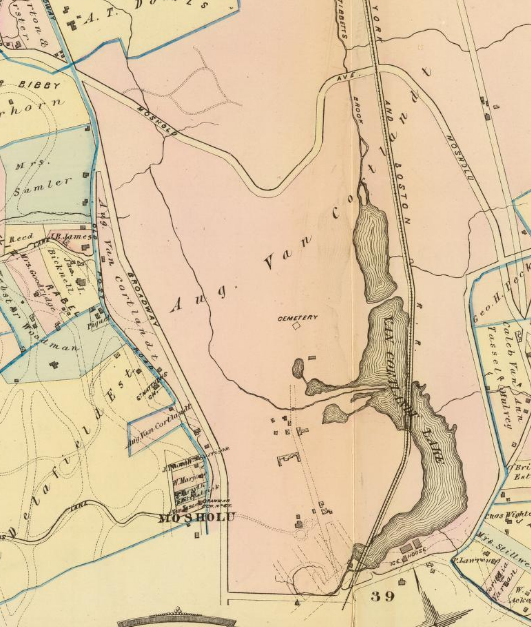 Number 5 listed above is referring to “Turtle Brook”–interesting to know that the Van Cortlandts got their drinking water from there. That’s the long stream in the above map crossing the parade ground and emptying into Van Cortlandt Lake. Frederick Van Cortlandt’s 1749 will uses the name “Turtle Brook” for the stream.
Part 2 of Harry Emery’s article is below. Some of the place names he uses are great to know as they have disappeared from the local vernacular (like Scotch Hill). Again, this map can be used to compare with the property owners that he references and find the streams:
Thanks for the follow up. Interesting about Tommy Hsu but also the history of the Riverdale Press. It is certainly great for local history to have access to those stories. I use the Fulton Search site to read back issues.
Good old History in Asphalt–a good book to have!
I went and looked in the 1880 census and there is a street labeled “Finnegansville East Riverdale Ave.”
The first person listed is John Finnigan, a 67 y.o. farmer from Ireland. The rest of Finnegansville is composed of 1 person from England, 4 New Yorkers, and 38 Irish immigrants or children of Irish immigrants. Every single person listed as living on Mosholu Ave was an Irish immigrant or the child of an Irish immigrant. Irish Town indeed!
I looked into this at one point but could not turn up much information on Calder in Spuyten Duyvil. I remember reading that he attended school in our area but I could not figure out which one. Calder’s circus at the Whitney Museum was one of my favorite exhibits as a kid so I was eager to find out more but to little avail.
Over July 4th weekend, I was lucky enough to spend some time at a family friend’s country house out in eastern Long Island. The town we stayed in was described to me as having two main groups of people–the wealthy professionals from New York City that have country houses out there on the one hand and the “townies” on the other.
Riverdale, for much of its history, seems to have had the same dynamic. There have been many prominent individuals, from Mark Twain to JFK to Lou Gehrig to Ella Fitzgerald to U Thant, to live in Riverdale. I could be wrong but it seems these folks were here to get away from people, not to be active members of the community.
Even in colonial times, the Riverdale area was a place for prominent New Yorkers to have their “country seats.” But if you look at the common folk of our area in those years, they were related by marriage to their neighbors. It was actually a very tight knit community. Whereas the wealthy Manhattanites married into other wealthy New York families and had little to do with their neighbors. I have never read anything about tensions between these groups but they seemed to operate in different spheres. That phenomenon might explain the neighborhood’s lack of connection to U Thant.
U Thant lived here for about 10 years on a 5 acre estate and sent his kids to one of our elite private schools. I sort of doubt he went to community board meetings and got involved in Riverdale politics/activism. Plus Riverdale is home to a large Jewish community that would be sympathetic to Wallenburg, who saved thousands of Jews from the Holocaust. I am sure that has something to do with the naming. Additionally the forest was named during the Cold War. As Peter mentioned, Wallenburg was believed to be alive in Russia. Remember, Riverdale is home to Natan Sharansky Square at Mosholu Ave and W. 255th Street. I’m sure that street naming had similar roots–a way to honor a person who was working on behalf of Jewish people while at the same time sticking it to the Soviets.
Still, I see your point Stephanie. It is not like Wallenburg really had a connection to Riverdale. It would be interesting to hear what Tom Bird has to say about the name.
Here is a video of U Thant at his home in Riverdale: https://www.unmultimedia.org/avlibrary/asset/2602/2602271/
June 30, 2021 at 4:33 am in reply to: Ethical Culture Fieldston Campus and Lincoln’s Collector #2026Here’s another map; this one from 1881. You get an idea of what they were planning for Spuyten Duyvil Parkway in this area. Today’s Brust Park and the pedestrian/bike path next to the Manhattan College Student Center were all supposed to be part of Spuyten Duyvil Parkway:
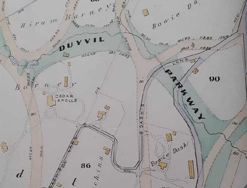
The parkway followed the course of Stony Brook. It looks like the City acquired that land in an unusual manner, perhaps condemnation, from Hiram Barney as Barney filed a claim against the City as did other neighborhood residents (from the 1/20/1883 City Record):
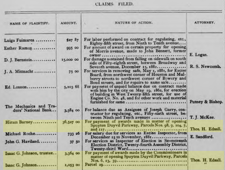
Interesting to see that the neighborhood folks seeking claims from the city were represented by Thomas Henry Edsall, the area’s first local historian.
June 26, 2021 at 2:19 am in reply to: Ethical Culture Fieldston Campus and Lincoln’s Collector #2023The name Kingsbridge actually did receive the most votes at that 1872 meeting so that is the name that was chosen as the official name of the municipality, which included the neighborhoods of Fieldston, Riverdale and Spuyten Duvyil.
Van Cortlandt Heights was the name given to the land of the Hiram Barney Estate when it was divided up into lots and put up for Auction. I would imagine the auctioneer came up with that one:
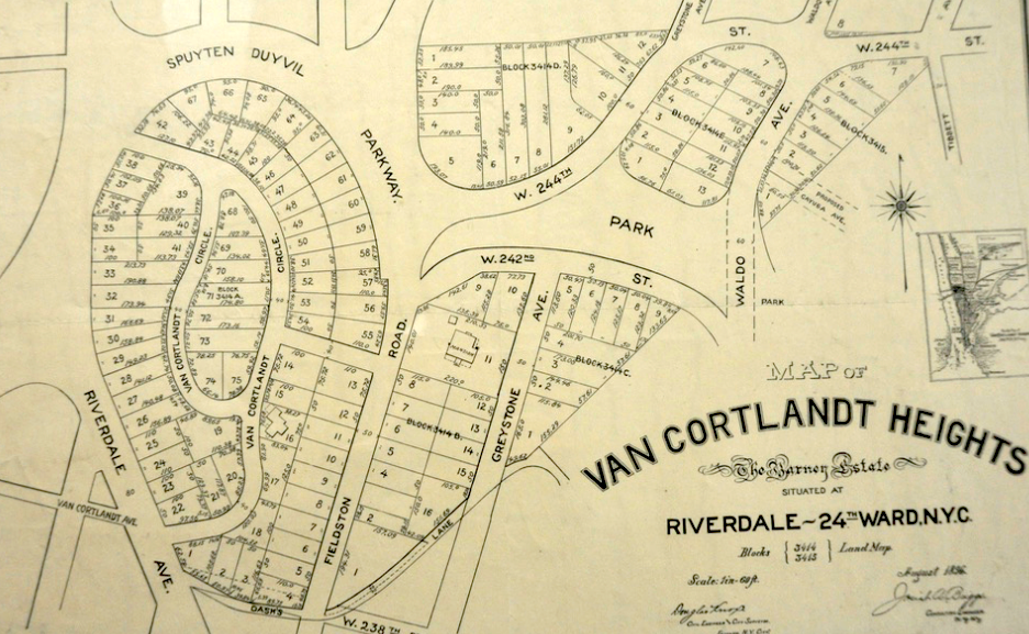
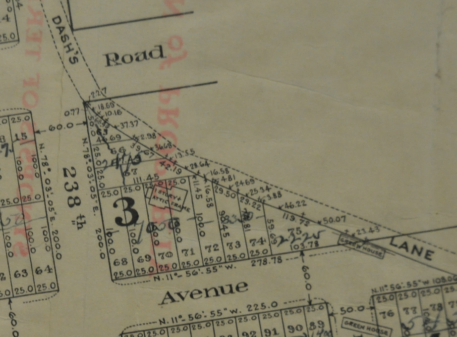
And your family’s property on the northeast corner of 238th and Greystone would have been on the other side of “Dash’s Lane” so not part of Barney’s property. It belonged to Barney’s neighbor Waldo Hutchins. The Hutchins estate was put up for auction in 1909:
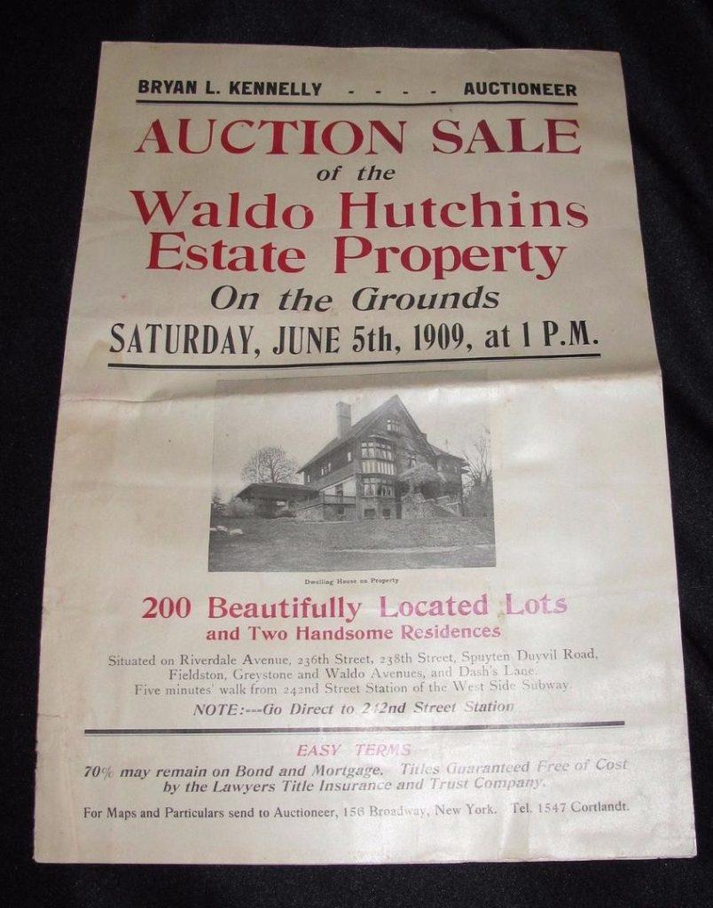
You can see your family’s former property the Waldo Hutchins Estate Auction Map:
And the Dash estate also sold in 1909, I believe. The neighborhood went from being large sweeping country estates to small lots with modest homes in a very short period of time. Rapid transit spurred this on it seems (from the Hutchins estate brochure):

One resource that has paid dividends in the past is the page hosting the Parks Dept. “Historical Reports, Press Releases, and Minutes.” You can find that here. If I come across anything else, I will send it your way.
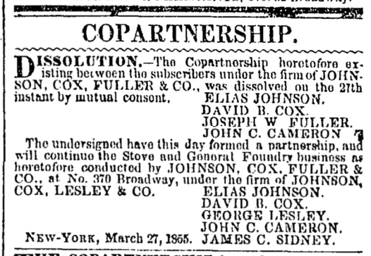
I am thinking that image has to be looking east from a boat on the Hudson. You are looking over the railroad causeway toward the foundry which was on the peninsula jutting out from what is today the “C” Rock. There was still no railroad on the north bank of the Spuyten Duyvil Creek in 1856. That line, the Spuyten Duyvil and Port Morris RR, was built in the early 1870s.
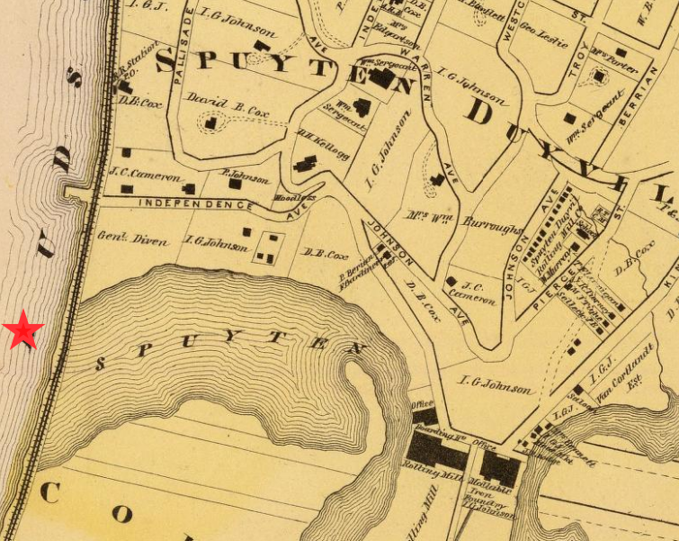
I think the view is from about where the red star is on the above 1868 map. Many of the large property owners named on the map were the industrialists involved in the foundry work. All the names mentioned below in this 1855 New York Times notice can be found living on Spuyten Duyvil Hill.
 June 7, 2021 at 6:23 pm in reply to: Importance of Local History – the African Burial Ground at Van Cortlandt Park #1996
The event will be live-streamed by the Van Cortlandt Alliance, the event organizers, on June 19th at 11:00 AM at https://www.facebook.com/vcpalliance/live
You will not need a Facebook account to watch.
It does not look like it will be on television at this point.
June 7, 2021 at 2:44 pm in reply to: Importance of Local History – the African Burial Ground at Van Cortlandt Park #1993The event is set to begin at 11 AM. The Van Cortlandt Park Alliance is coordinating it and as soon as they release the details on the live-streaming I will post them here.
Not in any ongoing sense.
But if you are interested in back issues of “Tube Collector” magazine, you can read articles about De Forest’s work in Volume 1 and a special 105 page issue all about the tube collection at Manhattan College!
That’s fascinating to know. I wonder if anyone in the engineering program at Manhattan College knows about this neighborhood connection. Some of the conference rooms in their engineering program are filled with old vacuum tubes on display. At one point they even had a vacuum tube museum with thousands of tubes organized into displays by Brother Patrick Dowd. I am not sure if they still do.
There is some information in the Rev. William Tieck’s book, “School and School Days in Riverdale – Kingsbridge – Spuyten Duyvil.” Apparently, the original P.S. 24 was closed in 1940 due to low attendance. The Iron Foundry had been shut down in the 20s and this greatly reduced the student population as the foundry workers and their families moved on. The P.S. 24 visitor’s book recorded this last entry, written by the principal of P.S. 7.
Friday, Nov. 29, 1940
P.S. 24 Bronx closes to-day–rather sudden though expected!
Records from 1865 indicate that P.S. 24 & its forerunner in this locality have done an excellent service. Perhaps other school activities may be assigned to P.S. 24–a wonderful building in a historic & beautiful setting. Henry Hudson anchored just across the water; that famous Dutchman who swam the water “in spite of the devil” gave the name to this locality & to this school–“Spuyten Duyvil.”
After a long & useful career the march of time, & the trend of population have combined to close the “school on the hill”–truly a “little red school house.”
Now I know the full meaning of Kilmer’s “The House with nobody in It.”
What can be more desolate & more saddening than an abandoned schoolhouse! Think of the thousands of happy voices, the stamping feet, the busy hum of work!
“Sic transit gloria.” Farewell “24.”
– Joseph T. P. Callahan
The building was built in 1891 without indoor bathrooms (there were separate outhouses for girls and boys) and before school buses. Check out the below article from “School” magazine, written in 1899:
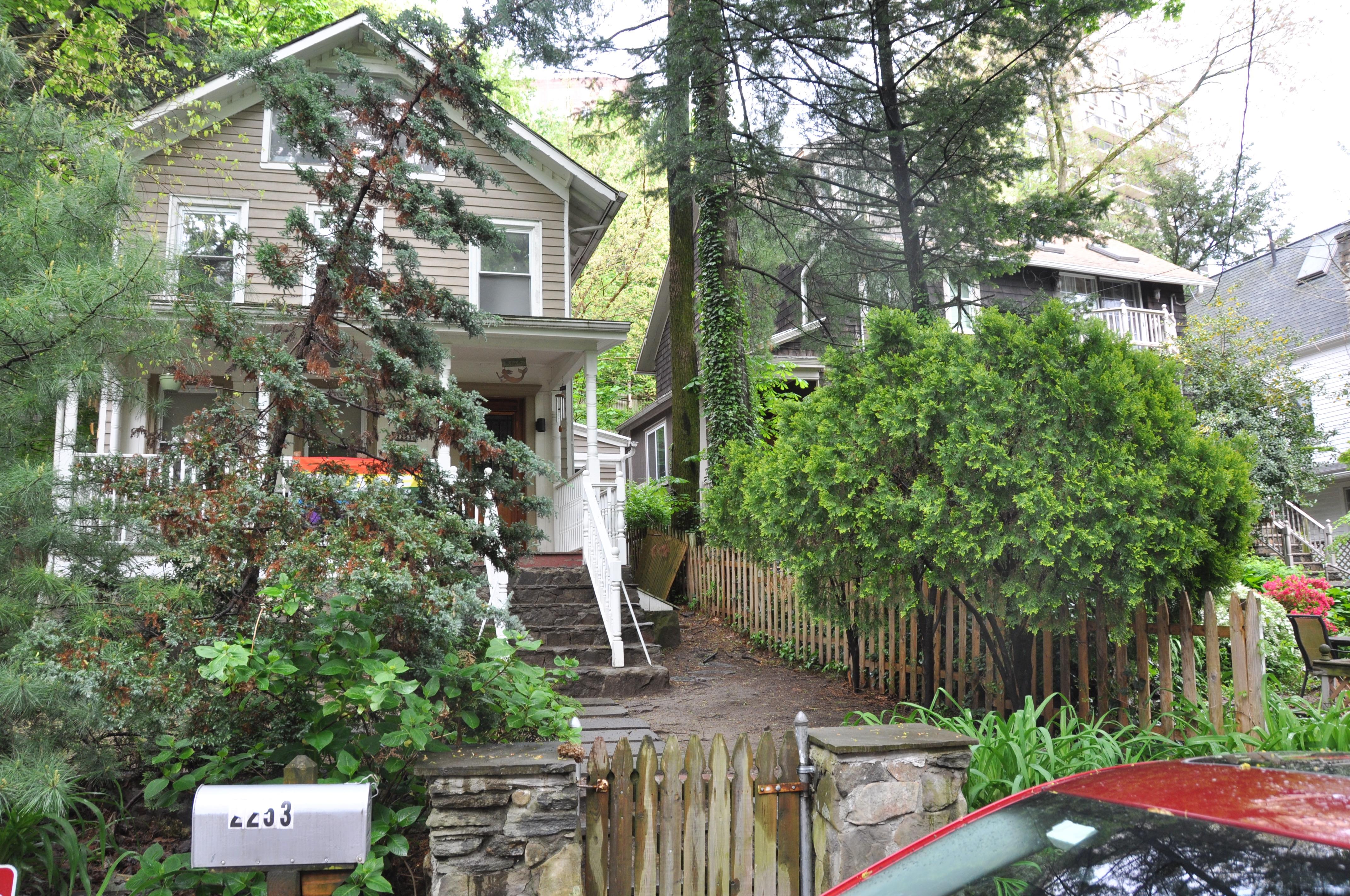
I just happen to be in the area today and I drove down Edsall Avenue just to see if I could spot the house that George Bolint is standing in front of in the photo with the geese. I am pretty sure it is 2253 Edsall Ave (the house on the left):
Nowadays, the houses on Edsall Ave routinely sell for over one million dollars. But they were working class houses in the past as George Bolint’s memories would suggest. Several years ago, the house at 2251 Edsall Avenue was put up for sale and I went to see it. Despite being over 100 years old, it only had a couple of owners and had never been renovated. It was in pretty rough shape honestly. The front door fell down the stairs when someone tried to open it to greet me. It was sold to a house flipper for $275,000, who fixed it up and sold it for $750,000 a year later. But when I visited, it was like a house that was frozen in the early 20th century. The kitchen was in the basement and the older woman that lived there offered to make me tea, which she did on this old stove:

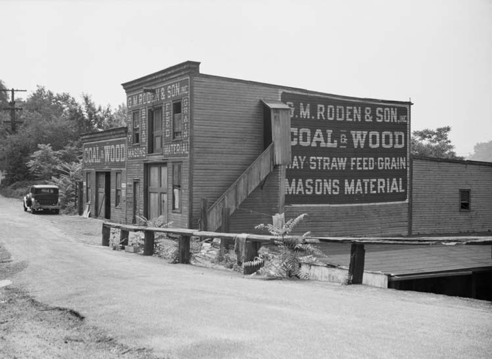
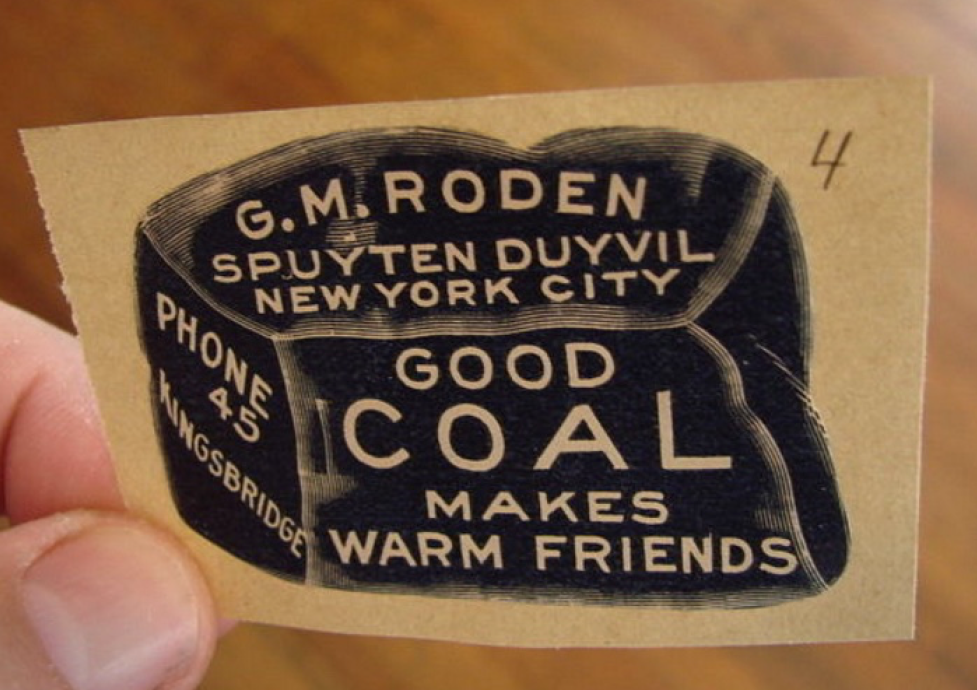
The stove could be heated by gas or coal. Speaking of which, the coal yard that George Bolint wrote about was a well-known area business: G.M. Roden’s.
Here’s their motto and logo:
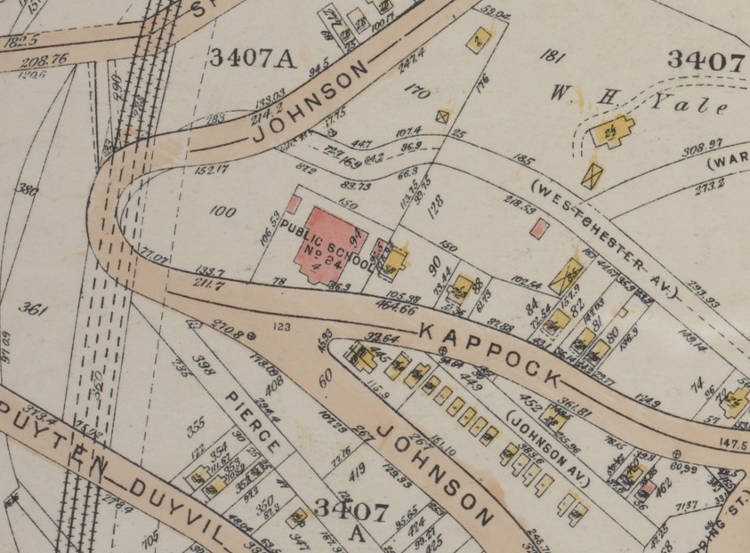
P.S. 24 was once the most visible landmark atop Spuyten Duyvil Hill–being a relatively large building with no other tall buildings around it. This 1930s map shows where it was:
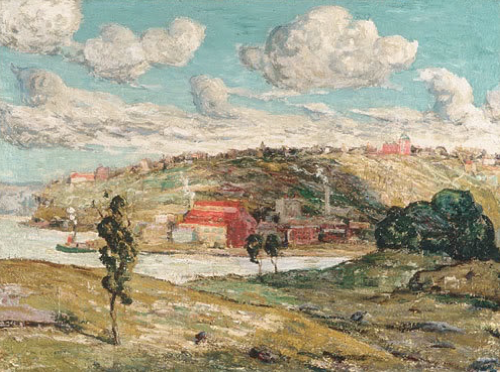
It was a red brick building with a green copper cupola. The building is visible in many old photos and paintings with the hill in the background. In this Ernest Lawson painting, you can see it on the right hand side (the view is from Inwood):
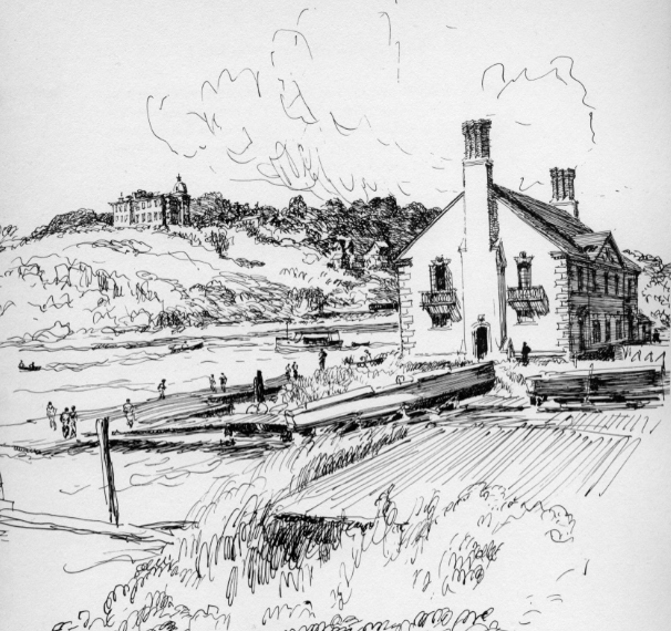
In this Vernon Howe Bailey sketch, you can see it on the left (that’s the Columbia Boathouse in Inwood on the right):
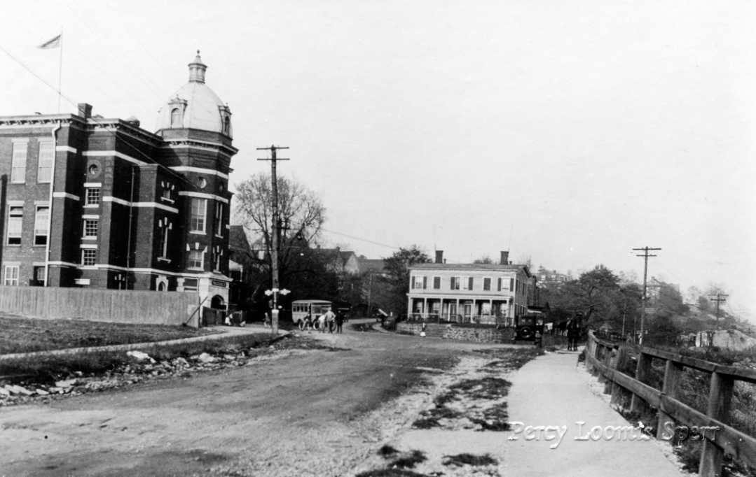
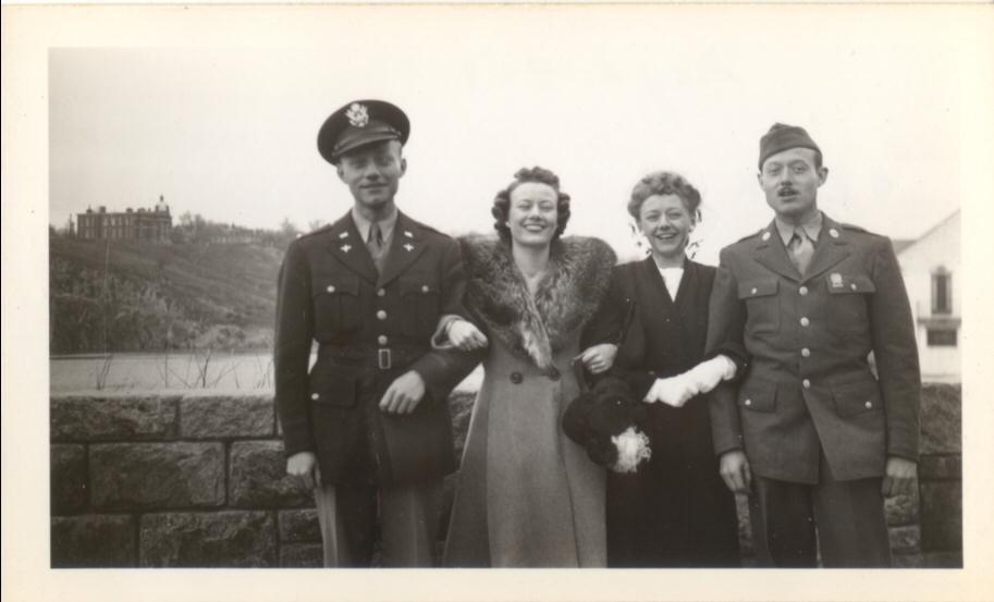
Here is a family photo taken from about the same spot (PS 24 is on the left):
 Here is a shot taken from about where the Kennedy Campus is today:
I believe it was torn down in 1940. The students must have had a heck of a view of the city with no tall buildings blocking visibility. I bet they could have seen the Empire State Building being built from the 2nd floor windows.
The Historic House Trust of New York City produced a “Cultural Landscape Survey” of Van Cortlandt Park in 2003 and included this image:
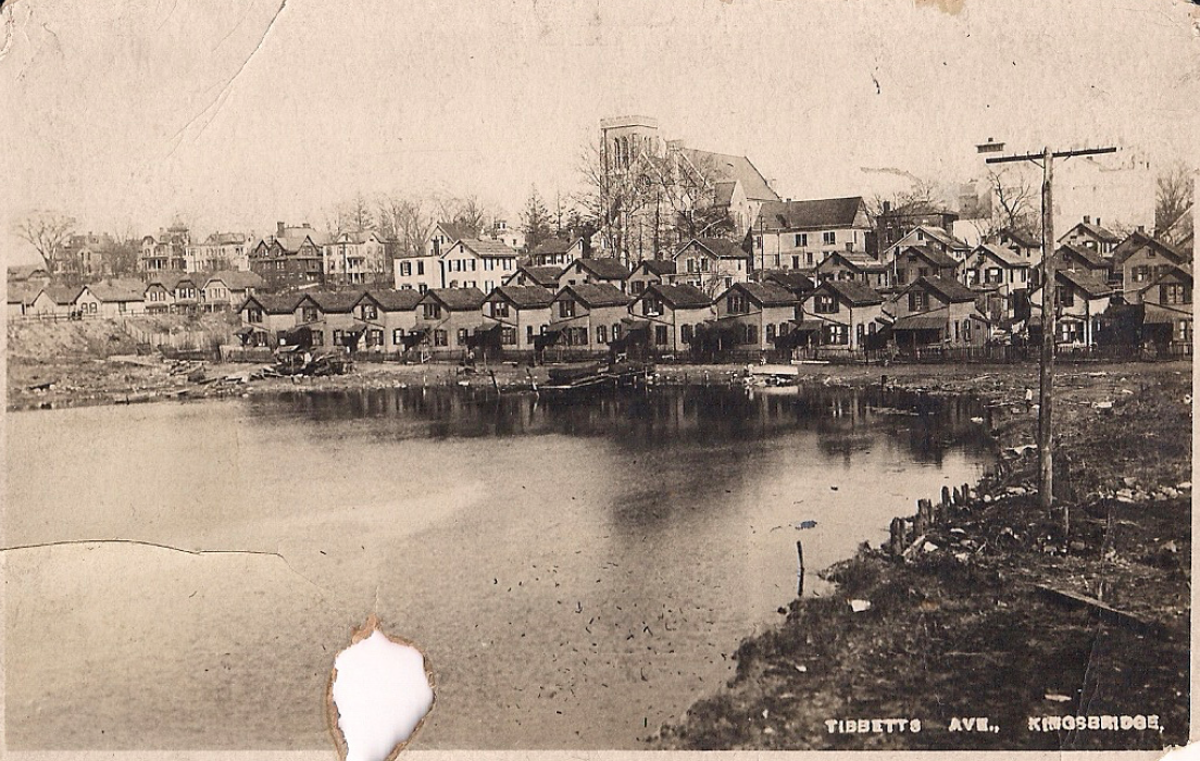
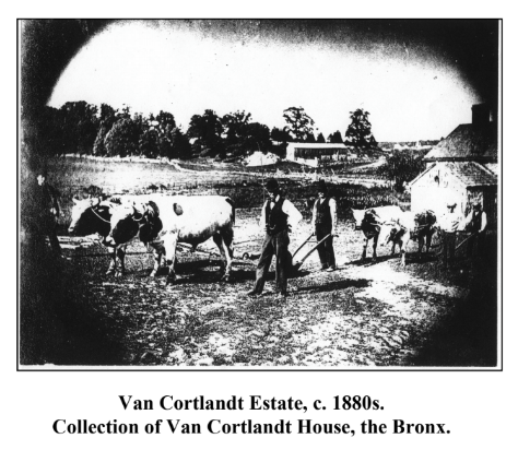 I’ll have to see if I can find a better copy and if anyone can explain the perspective of the photo. It is worth noting that Van Cortlandt wasn’t the only large farm in the area at that time. Just to the north of today’s Van Cortlandt Park was Boss Tweed’s “Valley Farm,” which stretched along Tibbetts Brook from Highland Ave (today’s McLean Ave) to beyond Yonkers Ave. The NYPL has a map of that one.April 25, 2021 at 6:04 pm in reply to: Local Organization Combats Housing Discrimination – On this Date in 1968 #1931
It is undeniable that the politics of today is a continuation and evolution of the politics of the past. Like you, I also thought of the article in terms of what is happening today. I do, however, want to remind everyone of our forum guidelines that you can find here. Those rules have not been violated–but it would be easy to see how contemporary politics could become the subject of heated debate here given the subject matter. That is something I was trying to keep off of the forum. Hence our first rule:
1. The society is an apolitical organization. We welcome people of all different persuasions. Please refrain from discussing contemporary politics on the forums. We are all here to further our knowledge of local history in a civil setting, not engage in controversial debate (at least not relating to modern politics).
If anyone wants to discuss the forum policies, you can do that by commenting on the thread containing the guidelines.
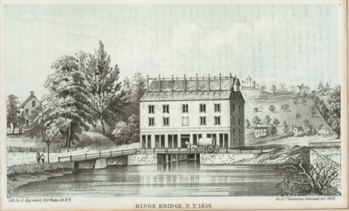
April 13, 2021 at 2:57 pm in reply to: Historic Black Kingsbridge 1698-1850 – A Community Revealed in Documents #1927I just received an interesting email comment about this, which suggested the possibility that Peter Pierson could have been a descendant of the miller on Van Cortlandt Plantation but ALSO enslaved by Alexander Macomb. That is entirely possible. Local people did sell enslaved people to one another. The Macombs, like the Van Cortlandts, operated mills on their property. The Macomb mill was much larger and was powered by the shifting tides on the Spuyten Duyvil Creek. It was located just next to the King’s Bridge. The below image is from a later date, of course.
Also, I wanted to share this very well done video series about Cesar, the enslaved miller that lived and worked at Frederick Philipse’s mills in Sleepy Hollow. It stands to reason that the mill in today’s Van Cortlandt Park would have looked very similar:
Part 1 – The Miller and His Apprentice
Part 2 – Caesar’s Skills
Part 3 – Recognition for Caesar
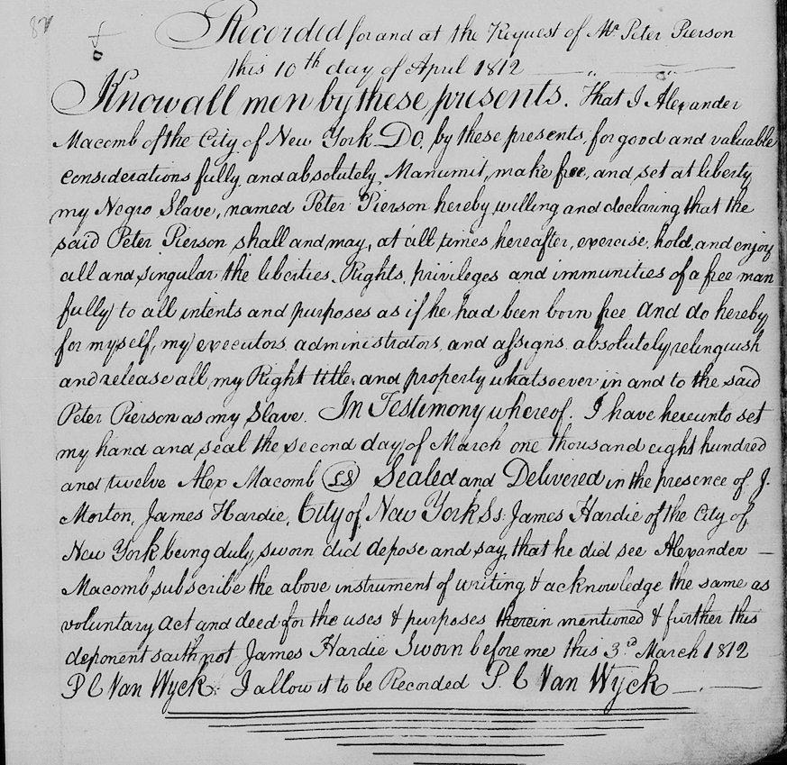
April 12, 2021 at 8:46 pm in reply to: Historic Black Kingsbridge 1698-1850 – A Community Revealed in Documents #1926The article I wrote about Van Cortlandt Plantation suggests that a free Black man that lived in the neighborhood named Peter Pierson could have been a descendant of Piero, the miller who worked on Van Cortlandt Plantation. I just came across a document that casts some doubt on that theory. In 1812, Alexander Macomb, who owned a good portion of Kingsbridge around today’s 230th Street, manumitted a man named Peter Pierson. So, the Peter Pierson who shows up in the census in our neighborhood could have been held by Alexander Macomb as opposed to the Van Cortlandts.
 March 26, 2021 at 1:38 pm in reply to: Developments in Kingsbridge – Corlear, Godwin, Broadway #1918
To circle back to the beginning of the thread, I got an email from Michael Tynan stating that the Land and Sea Restaurant was originally Arthur’s Modern Diner. I found plenty of references to it in the Riverdale Press (although the picture quality is not great):
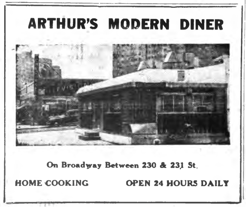
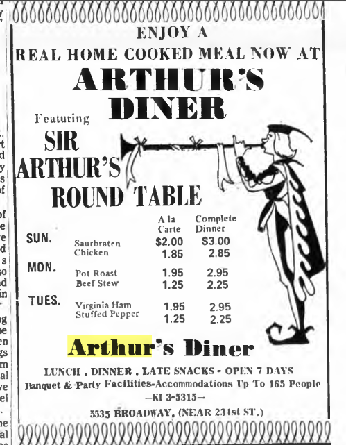
[caption id="" align="aligncenter" width="264"]
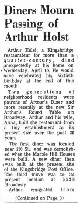 From the April 18, 1968 issue[/caption]
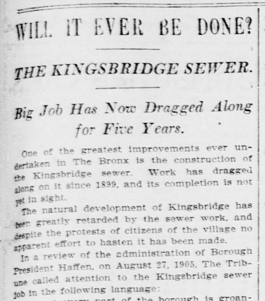
Getting back to the sewers, it is funny that I read that 1905 article and the cost didn’t really dawn on me but yeah, that is A LOT of money. I get the impression that one of the reasons why Kingsbridge voted to separate from Yonkers in 1873 was that many people wanted this work done and the city of Yonkers couldn’t afford to or didn’t want to do it. The Yonkers government was more focused on the Village of Yonkers, which was what they called today’s downtown Yonkers.
[caption id="" align="aligncenter" width="634"]
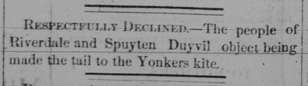 1870 Yonkers Statesman[/caption]
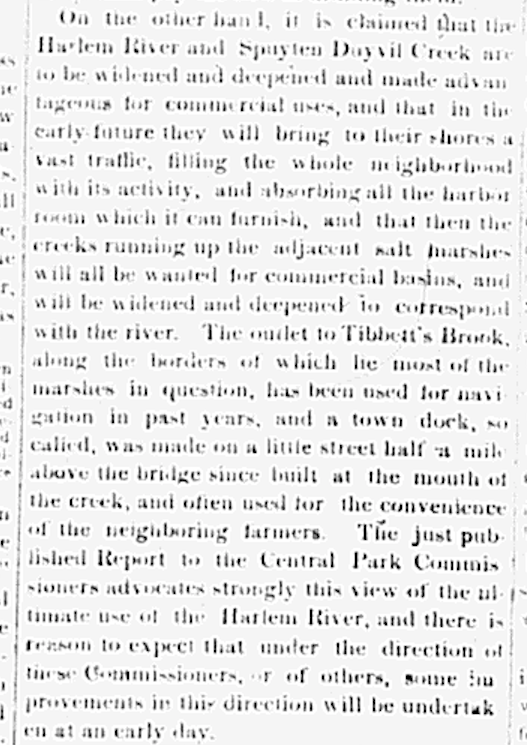
Today we have a greater appreciation for natural waterways and the benefits of salt marshes, which were very prevalent in Kingsbridge. And I am sure some local people treasured the natural ecology as there are many stories in the papers about fishing, crabbing, and people enjoying the water. Many photos show small boats pulled up along the banks of the creeks and many people wrote about the area’s natural beauty. But there were also stories about kids drowning, bridges in need of repair, the desire for a “water works,” and the benefits of dry land for development. No doubt certain parties stood to make a lot of money from the building boom that could occur once the swamps were gone as well. And then there were events like this, which probably did a lot to sway public opinion in favor of draining the marshes:
[caption id="" align="aligncenter" width="685"]
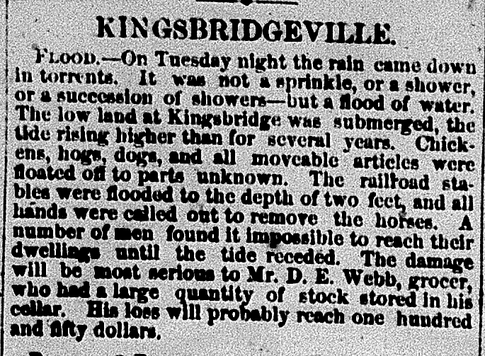 December 1, 1870 Yonkers Statesman[/caption]
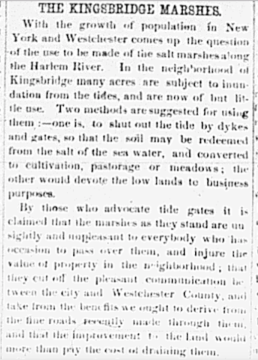
Some of the issues were presented in the below article from the Feb. 8, 1869 issue of the Yonkers Statesman if you feel like straining your eyesight:
 March 25, 2021 at 7:26 pm in reply to: Developments in Kingsbridge – Corlear, Godwin, Broadway #1914
Yes, that’s a great photo, Zach. Here is a similar one from a postcard:
The sewers, which you can see were built above street level in that earlier photo of Corlear, were something people in the neighborhood were clamoring for. And they took a long time to build. Before I saw the photos of manholes sticking up in the air like chimneys, I figured they probably dug below street level for the sewers. But Kingsbridge was already prone to flooding so it made more sense just to raise the whole neighborhood up. Here is a photo of W. 231st Street looking East from Broadway with Bailey Ave in the background. The manholes look like they are about 10 feet above street level:
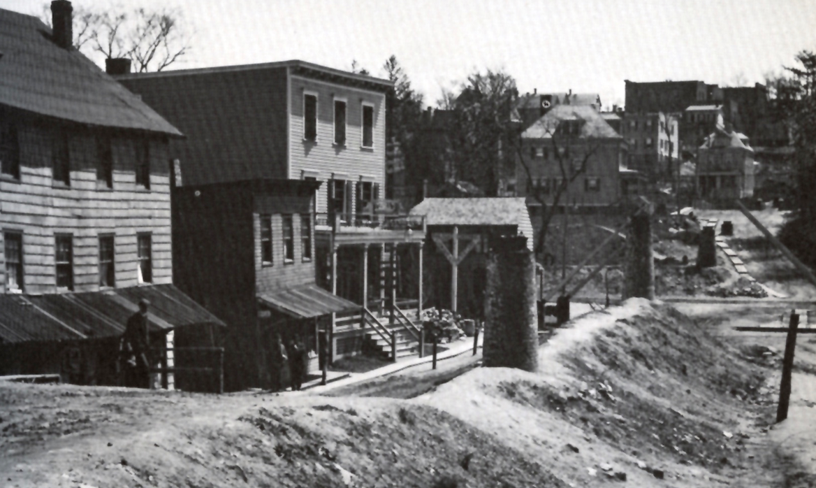
Here’s one looking south from the part of Riverdale Ave above the retaining wall:
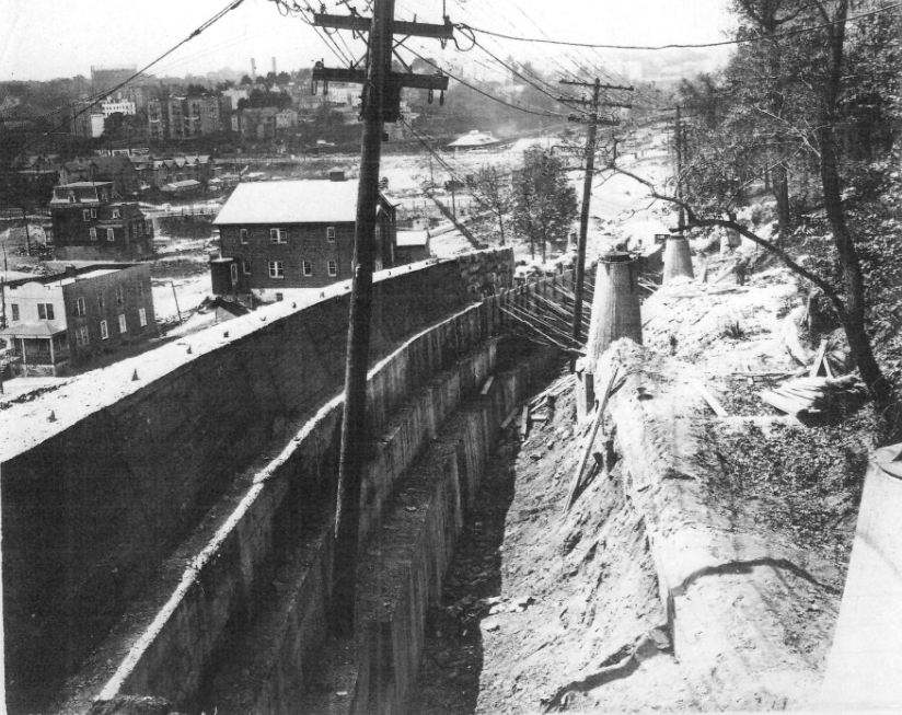
Here’s another of Albany Crescent looking north (as far as I can tell anyway):
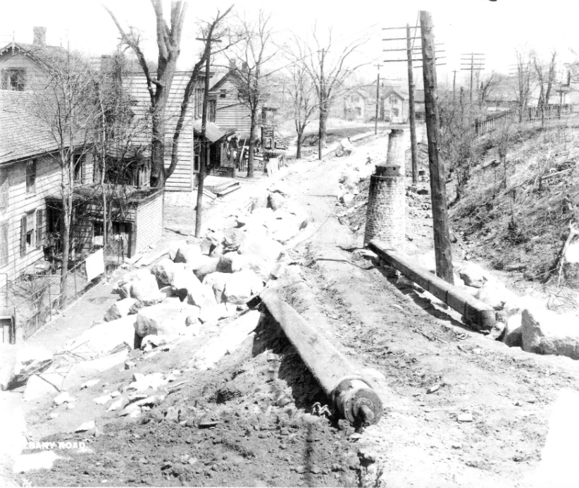
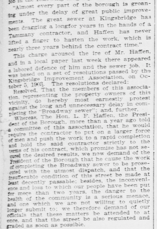
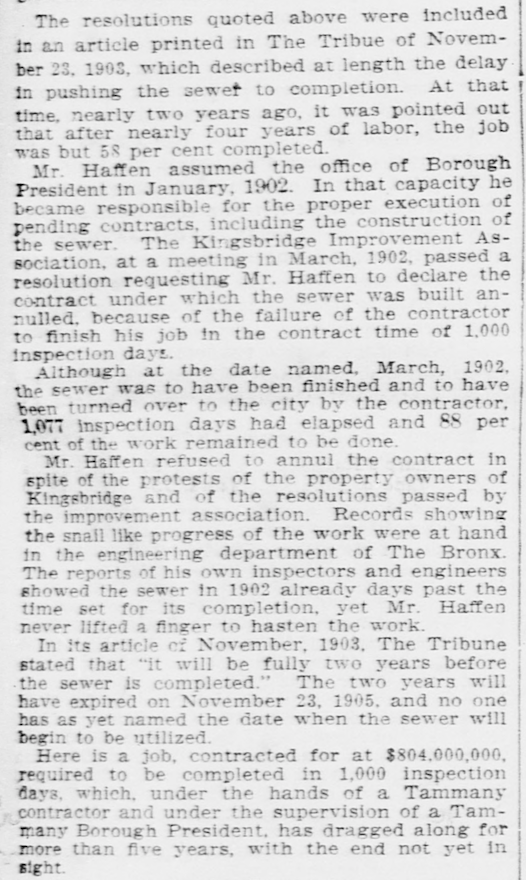
Like many construction projects in NYC, building the sewers took forever and went over budget. This is from the September 10, 1905 New York Tribune:
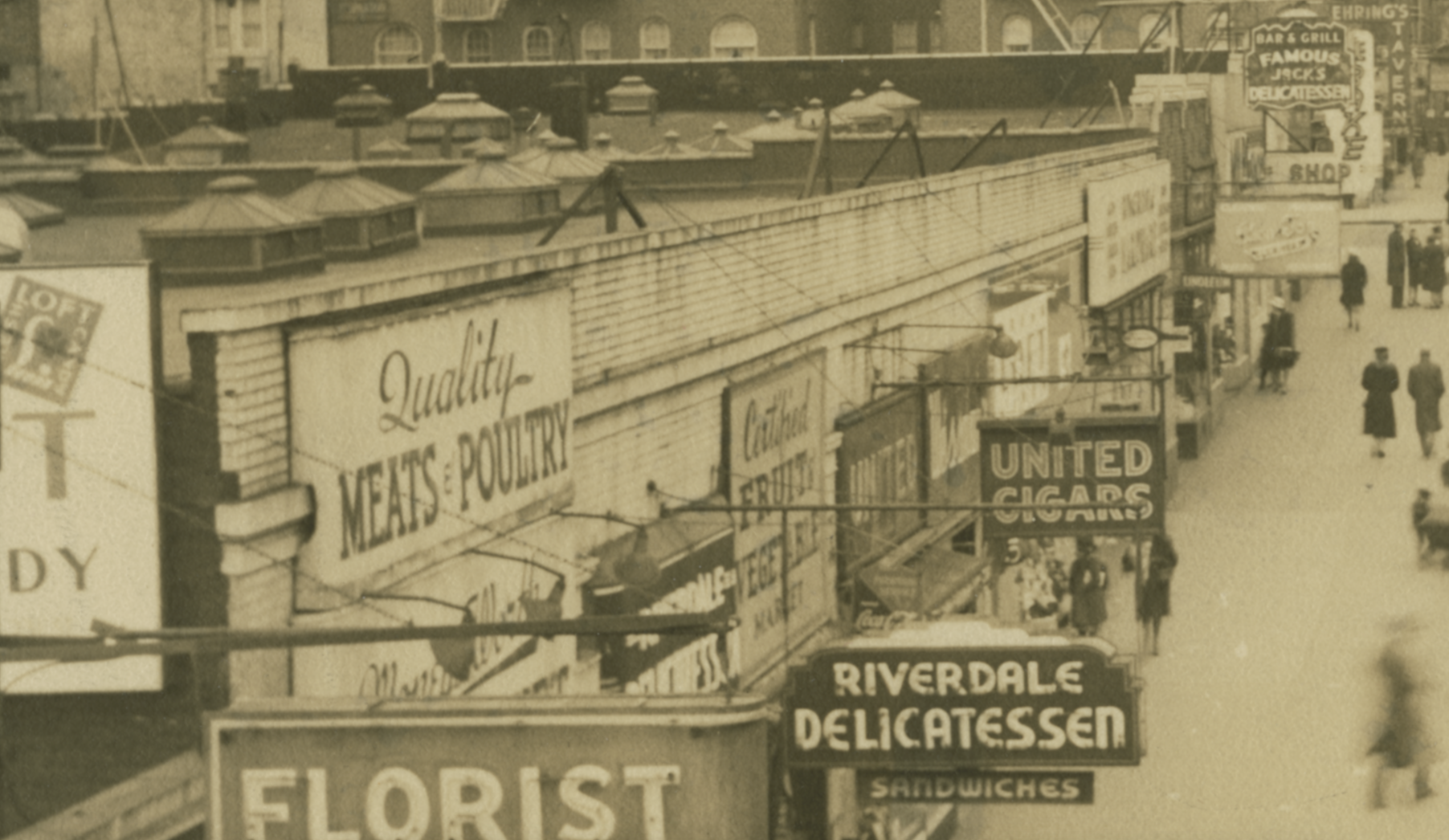
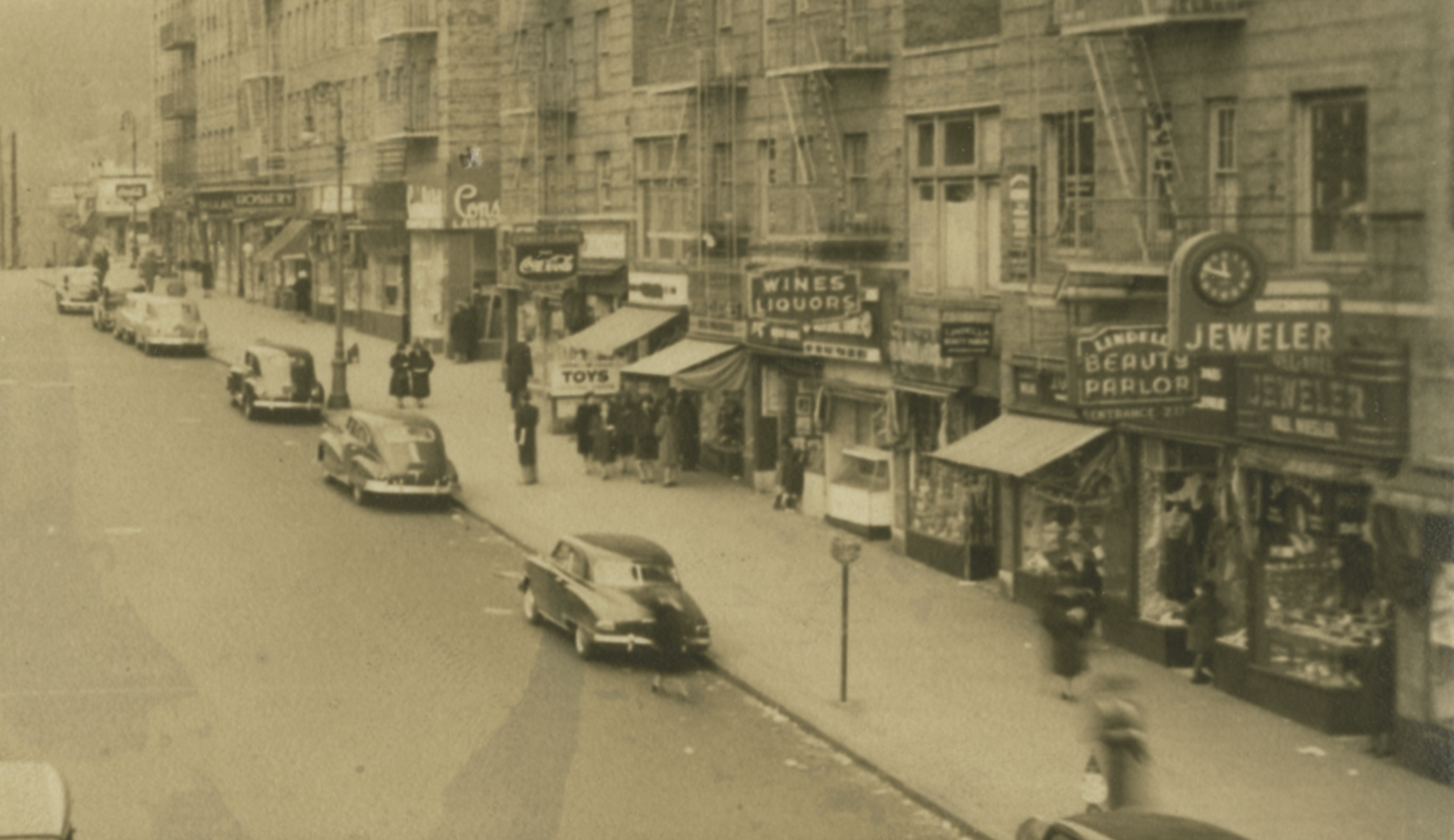
This is one of our most widely shared articles as many folks are thinking back to their childhoods in Kingsbridge in the 60s. Unfortunately, I have not seen any photos in our archives of W. 231st Street in the 60s. We do have a great one that I think is just a decade or two earlier though. It is undated and apparently taken from the train platform:
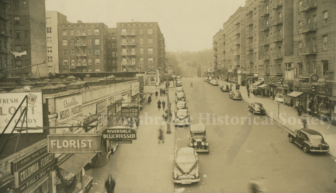
Maybe someone who really knows cars could give this a date. Zooming in on the north and south sides of the street:
Best of luck to your brother.
March 17, 2021 at 1:19 pm in reply to: Was the Albany Post Road earlier known as a “Mill Path?” #1909Yes, Zach, that’s what I think as well. I was surprised how swampy that land was given its higher elevation. Since this map was an intelligence map, they needed to know what were areas were off-limits for troop movements, cavalry, etc. Eric Sanderson used this map for his historical ecology project and that’s how I first learned about it–from his notes. When I first saw it, I was giddy because of all of the local history info.
I did a very rough geo-referencing of this map over a contemporary one that you can check out here:
https://kingsbridgehistoricalsociety.org/khsmaps/1781Clinton3/index.html#1781Clinton3/ol3
It’s not my finest work but it gives you an idea of where things were. Use the slider on the top right to adjust the opacity of map layer. You’ll be able to see the contemporary path of the Albany Post Road and the “Mill Runn” pretty clearly using it.
-
AuthorPosts