Forum Replies Created
-
AuthorPosts
-
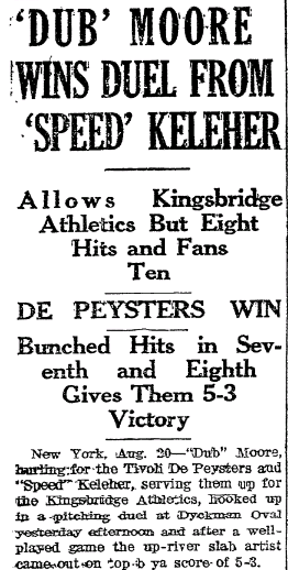
I found some game write-ups and box scores for the games here. The first link top left has one. New York Historic Newspapers is a great site and recommend it for research. If you find anything interesting about the team, please post it. The name Keleher is interesting. There was a middling player for the Brooklyn Robins of the same name, who was out of professional baseball at the same time that the Kingsbridge Athletics were playing. Maybe they were the same guy? Probably not but I would be interested to know for sure.
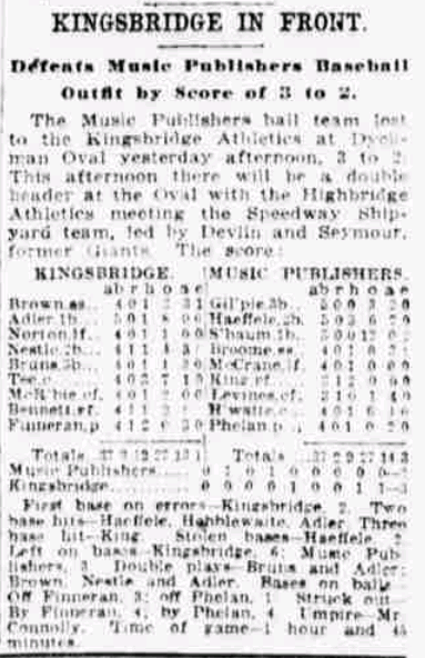
Here’s another:
If you are looking for more information than that, there could be something in the Riverdale News newspaper. The Lehman College library has issues dating from 1915. Next time I am there I will have a look at that time period and get back to you.
Can you post a picture of the Dyckman Oval?
Thanks, Tom. You are correct. Here is a Riverdale Press article that was published at the time. I believe it was Bowie Dash’s House (the man for whom Dash Place is named after).
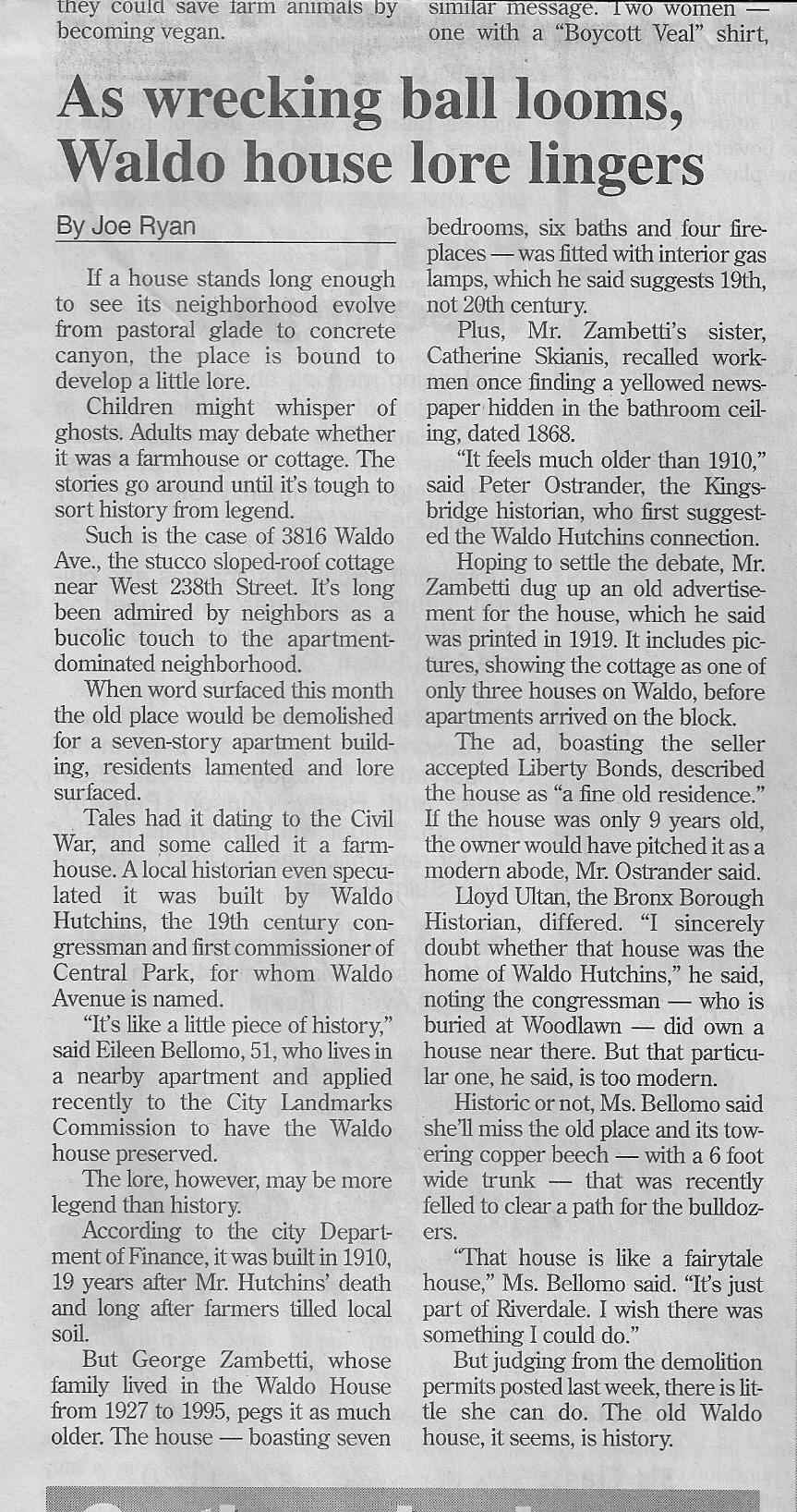
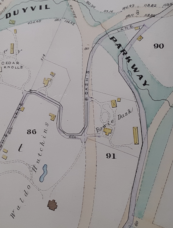
In the article Peter Ostrander says that the house was built before 1910 while Lloyd Ultan thought it was later based on the architecture. While it does not have the classic Victorian look, Peter was right. This 1888 map shows one house on the east side of Waldo Avenue (just above the “91”), which is a perfect fit for 3816 Waldo and it is labeled Bowie Dash. Waldo Hutchins’ houses were both on the west side of the street.
A local real estate agent took these photos. The chimney on the left is a clue to its Victorian era construction.
And what replaced it:
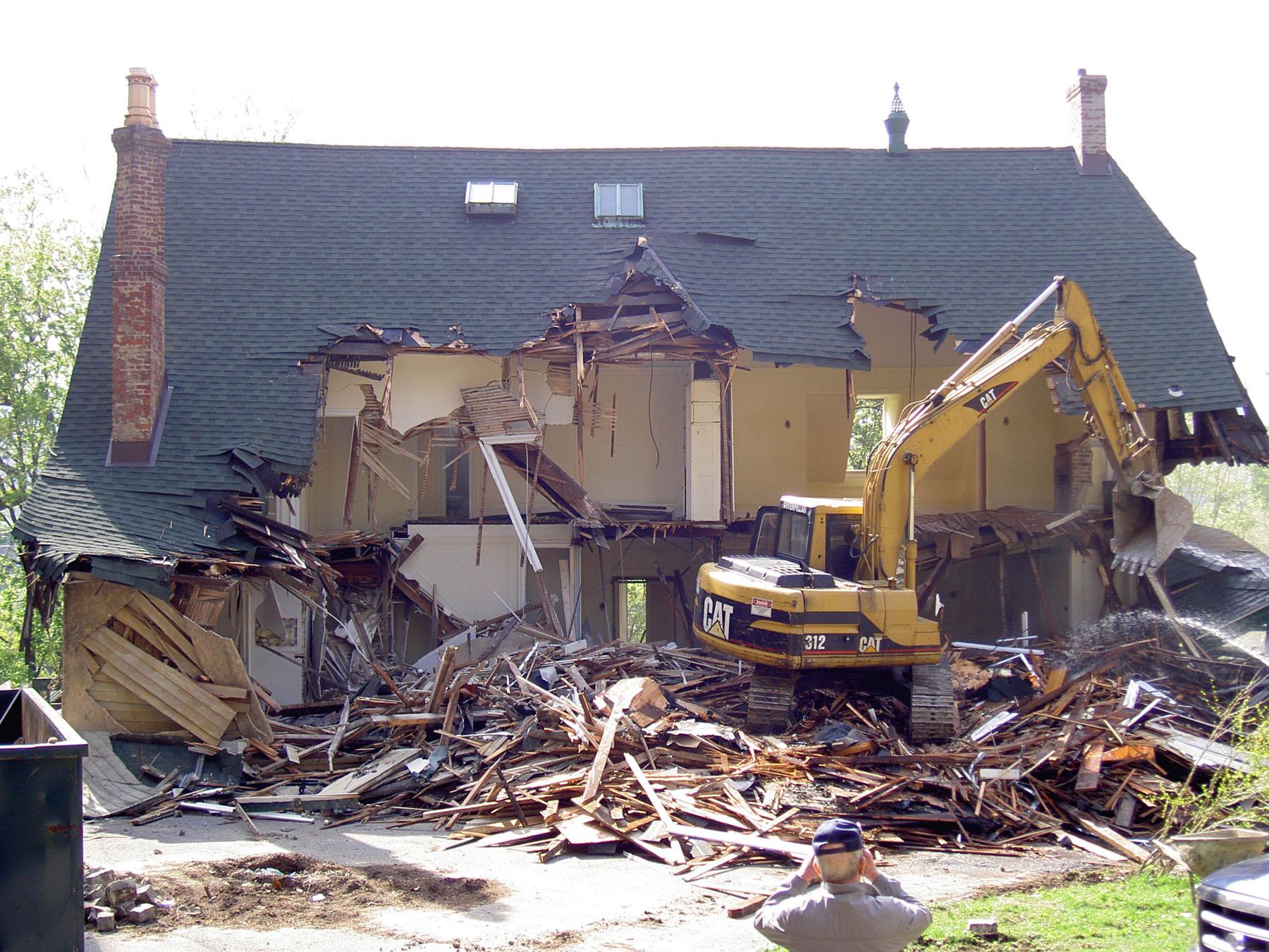
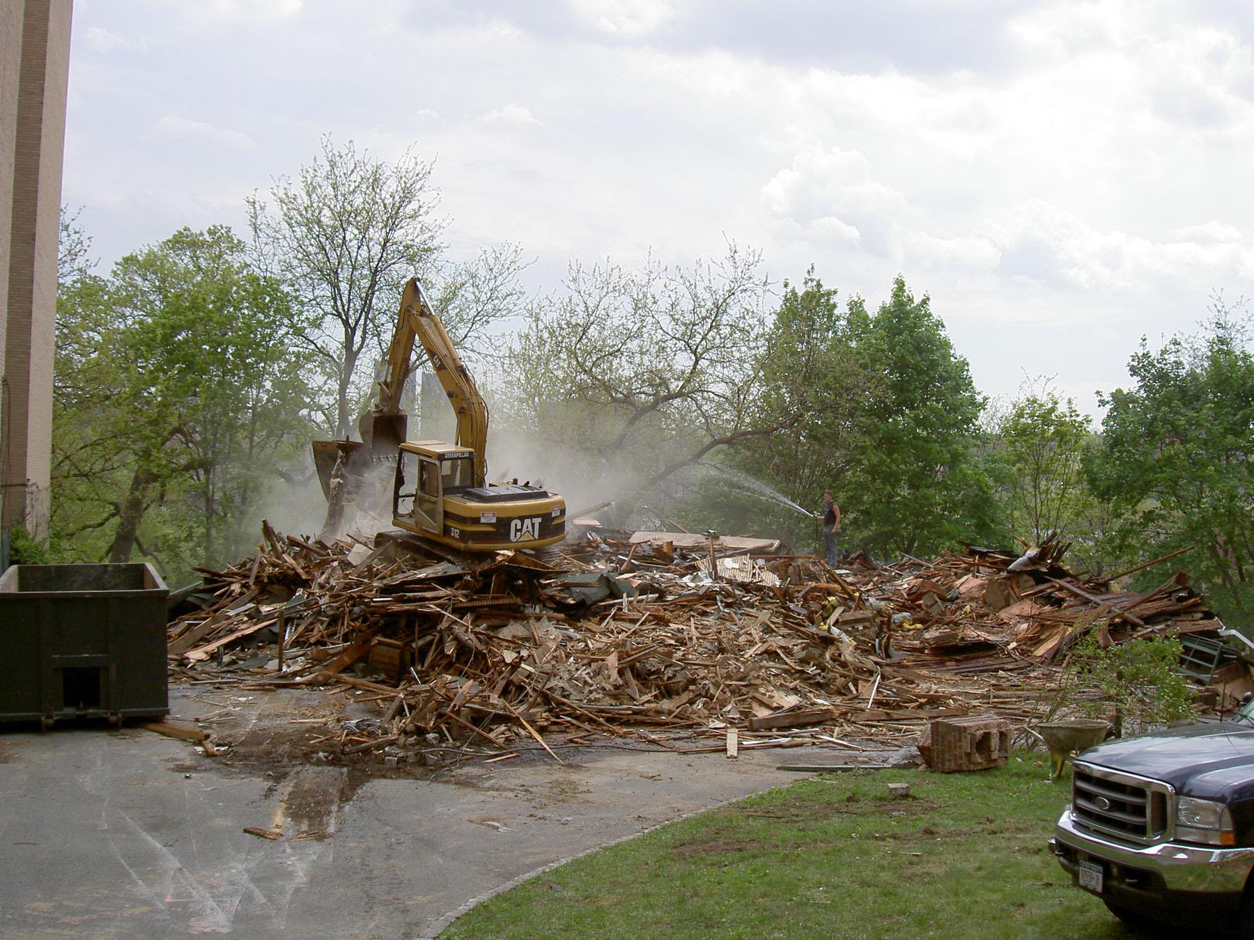
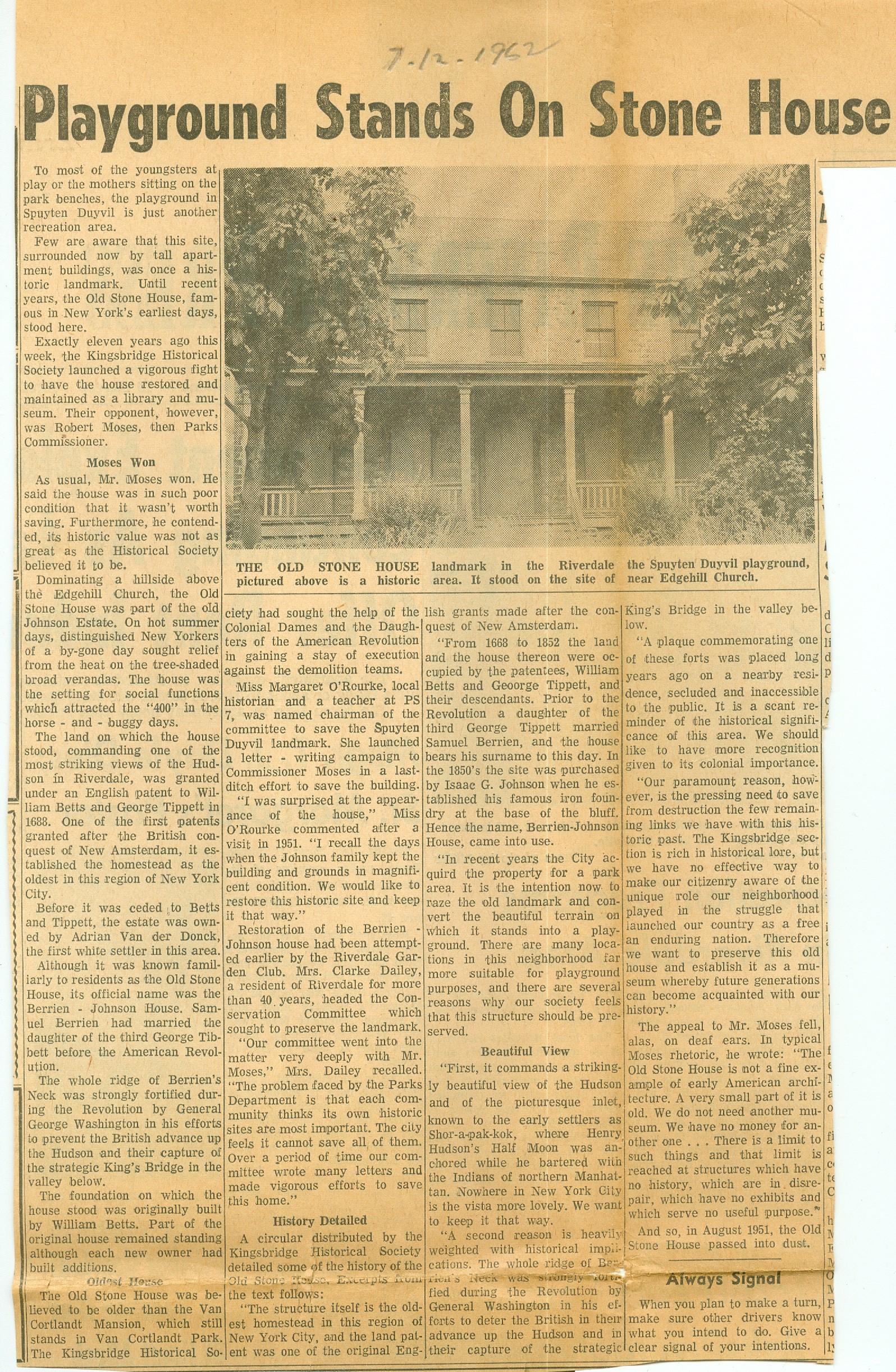
I finally know how the Berrian/Johnson house of Spuyten Duyvil met its fate. Thank you to Tom Casey for sharing this article. It sure would have been nice to have this house for KHS headquarters. After all, we are chartered as a museum in New York State. But unlike some other museums you may know of–we don’t have a building!
One thing I wonder is how the author figured that this house was originally built by William Betts.
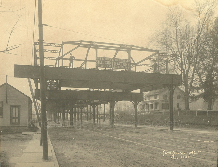
Thanks. Unless I am mistaken that is a carousel behind the Ferris wheel. The below photo was taken in April of 1908 so it was a pretty quick turn around for a completed station and amusement park.
 September 22, 2020 at 7:09 pm in reply to: The Moller Mansion – After 150 Years Are its Days Numbered? #1639
This week’s Riverdale Press main article puts the story of the house into context. Looking through the issue, there are so many stories about real estate development in one way or another. I figured that Coronavirus would have slowed this down but I guess I was wrong!
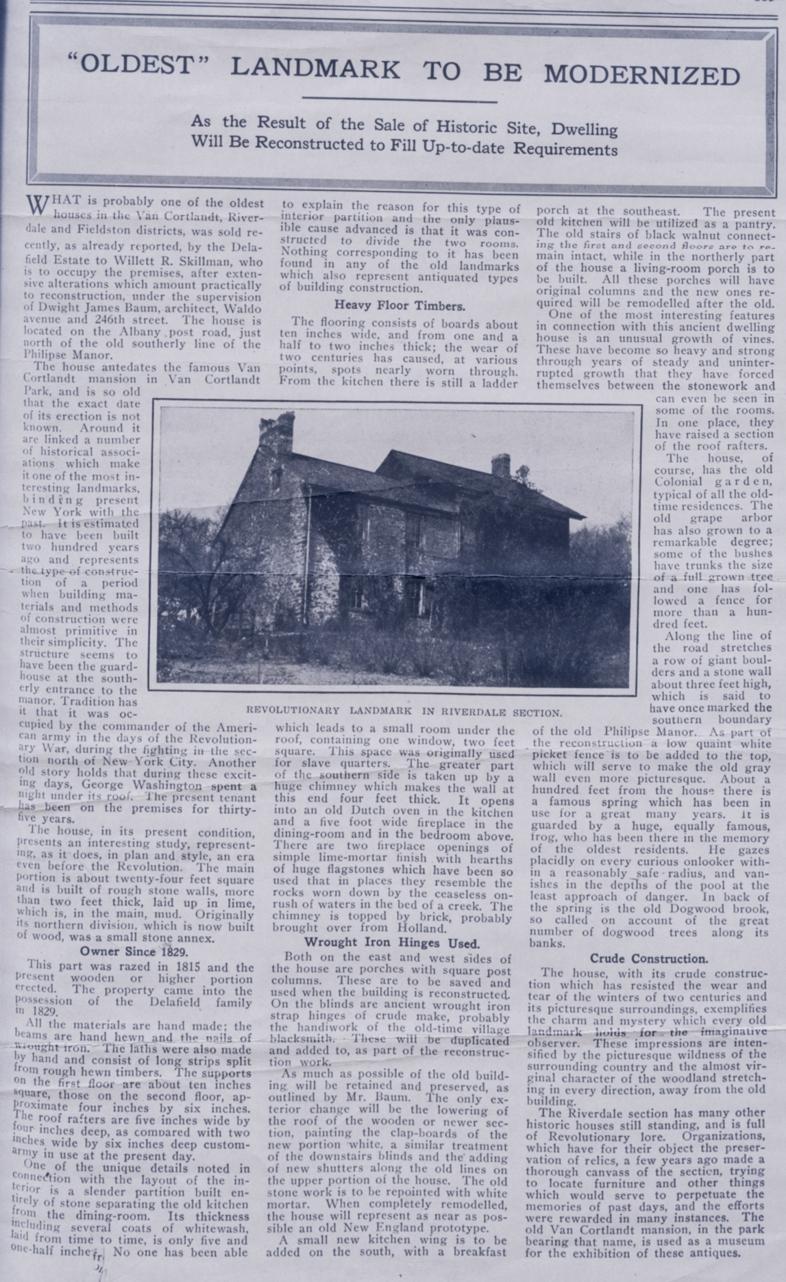
I am not sure how many history geeks took the time to read my deep dive into the history of the Hadley House at 5122 Post Road but I just came across this clipping with some interesting information. It was written at the time that the house was being remodelled by Dwight Baum, the Fieldson architect. The Hadley House is another local building that I am thinking about. While there are cars in the parking lot, there does not appear to be anyone living there. The roof has holes and the paint is falling off. It is landmarked but my understanding is that a building can lose its landmark status if not kept up. Anyway, the article claims that the house is older than the Van Cortlandt House, which would make it the oldest in the county:
 September 11, 2020 at 4:22 pm in reply to: The Moller Mansion – After 150 Years Are its Days Numbered? #1621
No, there is not an immediate plan to tear it down that I am aware of. The construction company that owns it mostly builds new buildings but they have worked on a restoration project as well. I am planning on reaching out to them to see if they would be amenable to a visit to take pictures to document the building’s features for the archives.
Thanks for an interesting post, Marty. I love the line about “skilled ability in dispensing satisfaction!” I have to confess that I don’t have a good idea of what the war years were like in the neighborhood although I imagine people felt the need to connect with their neighbors at places like the Old Bridge Tavern. I know I learned a thing or two about the neighborhood from the old bartender at The Piper’s Kilt before it closed down. Places like that help tie a neighborhood together.
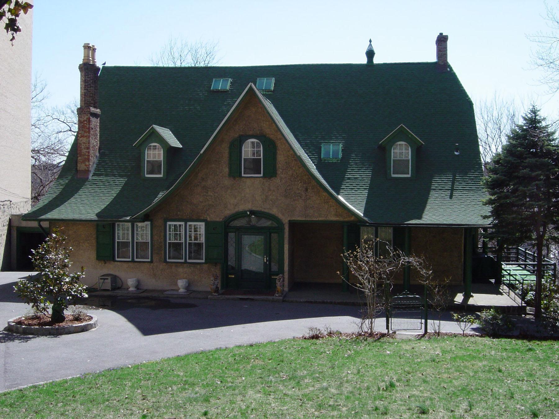
It is an interesting coincidence that you should post this today. Across the street from the Old Bridge Tavern stood another building from the Victorian period–the Moller mansion, which was built in 1870 and still stands at 3029 Godwin Terrace. Just today we learned in the Riverdale Press that this building was recently sold and the transaction bears all the usual signs of a demolition/development project site. It would be a shame to lose such a building 150 years after its construction. I will have more on this shortly.
[caption id="" align="aligncenter" width="420"]
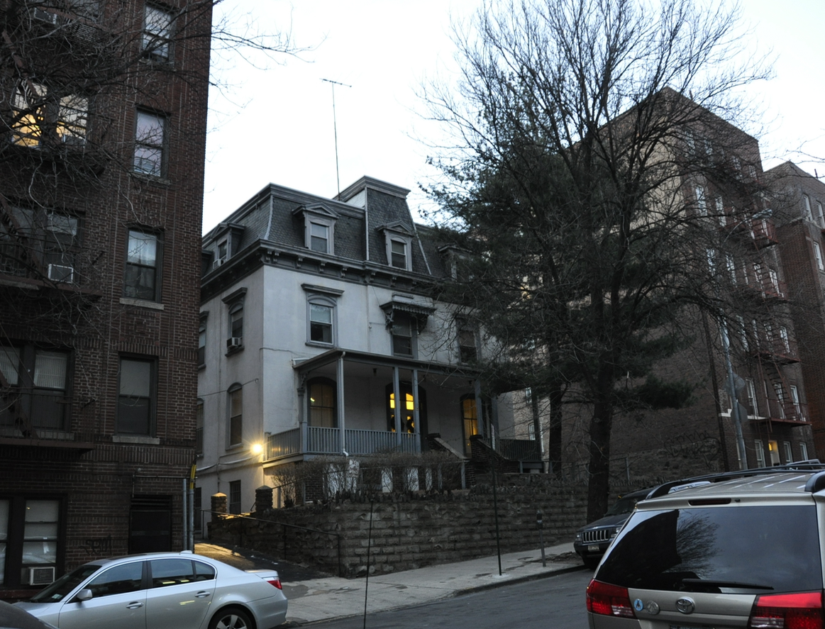 The Moller Mansion at 3029 Godwin Terrace[/caption]
Thanks for your comment, which reminds me to add to please keep in mind I am only writing very specifically about the northwest Bronx and our hyper-local history. This area’s history cannot be generalized to serve as a microcosm of U.S. history. The Dutch West India Company had different aspirations than Queen Isabella just as New Netherland colonists were a much different group than New Englanders. I would highly recommend Russell Shorto’s “Island at the Center of the World” to learn more about the Dutch colony and Adriaen van der Donck as a figure. Honestly, it is one of the best history books I have ever read. If we could afford Russell Shorto’s speaking fees, I would love to have him give a talk to the KHS–if Covid 19 ever ends. It is such fascinating history and so few people know it mostly because previous historians just assumed the Dutch period was largely irrelevant. Another amazing book is “First Manhattans” by Robert Grumet. His research on the Munsee during the colonial period is unbelievably deep and answered so many questions I had about the area’s native people. Grumet has also done tremendous research on the Munsee names for places in The Bronx and in the greater New York area. Much of what I learned, comes from Grumet.
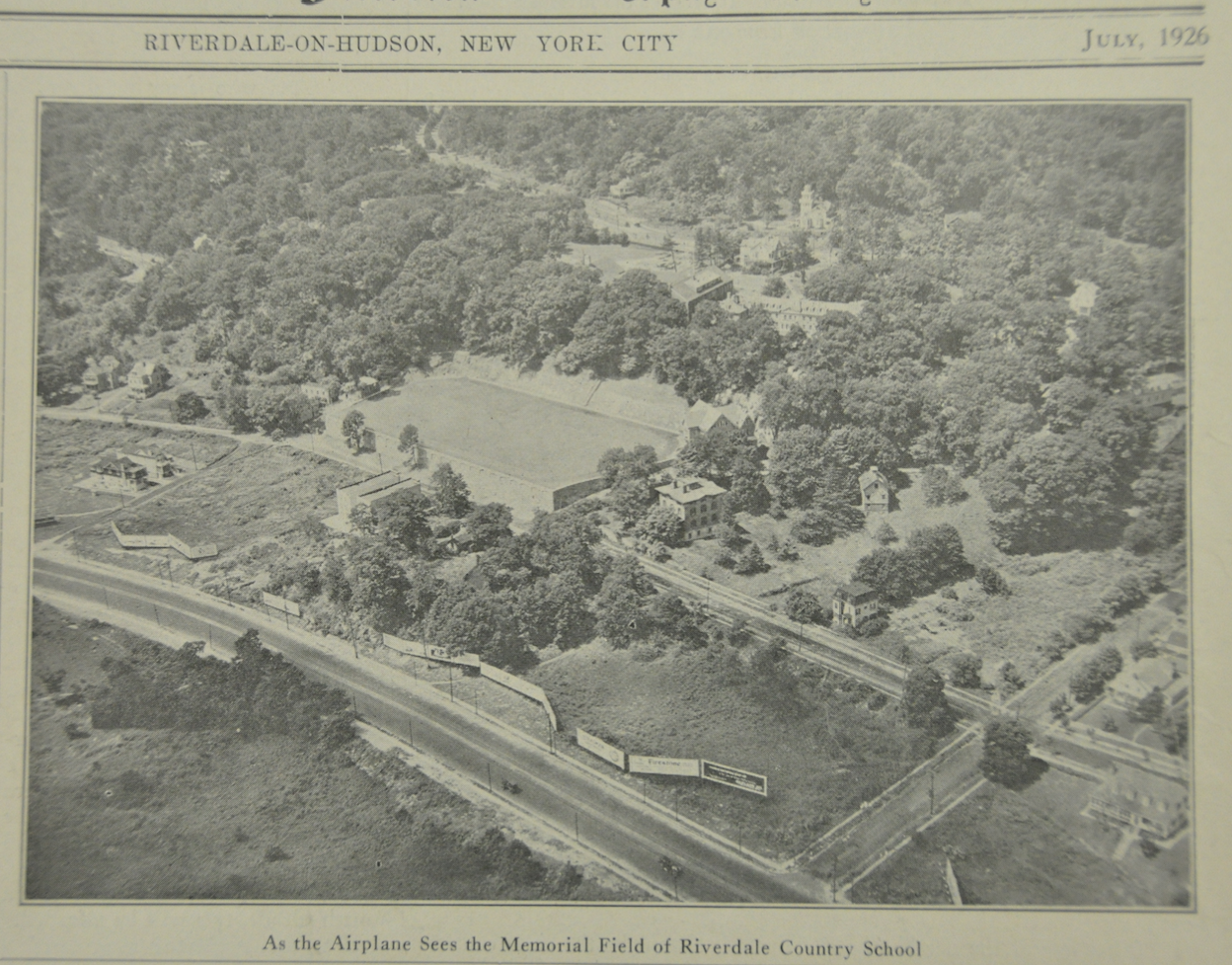
I wanted to add this photo to the thread since the topic of J.B. James’ house on Post Road was addressed above. This comes from the Riverdale News – 1926. The house is question is just to the lower right of the athletic field fronting on Post Road. This is less than 100 years ago and there are no buildings on Broadway–just billboards.
Interesting–I haven’t seen those photos before. I remember seeing photos of massive amounts of tulips planted in the garden as well and tulips are well-known symbols of The Netherlands.
I think the ridge is part natural. After all, artifacts were found on that ridge that predate European colonists. But seeing that map in high-resolution makes me think that it was also shaped by humans. It forms pretty neat little 90 degree angles in the corners, which would be pretty rare in nature. Jacobus Van Cortlandt also had Tibbett’s Brook dammed up to make the lake so he was not averse to changing the landscape.
It is a shame that features are built in parks and allowed to just fall apart. The stairs in Brust Park were like this too. Halfmoon Overlook in Spuyten Duyvil was also closed because the stairs were unsafe, I think. They get grants for capital projects so they can build something but the maintenance budget is very skimpy so they can’t keep it up.
Thanks, Tom. Great pics and info.
And of course there is the fact that Kingsbridge nearly became the original home of “the house that Ruth built.” The Yankees started building their original stadium here in the neighborhood where Target is today. They even finished building the infield there before a different site was chosen (where Yankee stadium is today). We wrote about that here and here.
And here is a little more information related to the monument and flagpole. It was funded by donations:

I regret that the KHS didn’t have an event at the 100th anniversary of the WWI armistice. Many local people served in the war (as the long list of names on the memorial bears out). Plus, there was the training camp in Van Cortlandt Park that is a fascinating story with great photos. Some photos and stories of the soldiers honored at the memorial can be found here:
https://www.findagrave.com/cemetery/2610083/memorial-search?page=1#sr-161185007
When the soldiers came home, they were warmly welcomed by the community (thanks to John Fischer for the below documents):
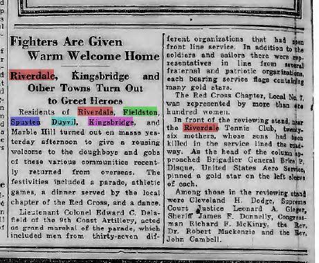
Here is a link to the booklet that was printed for the Welcome Home ceremony. It gives names and photos of servicemen:
https://kingsbridgehistoricalsociety.org/historicalDocuments/WW1ProgramRiverdale.pdf
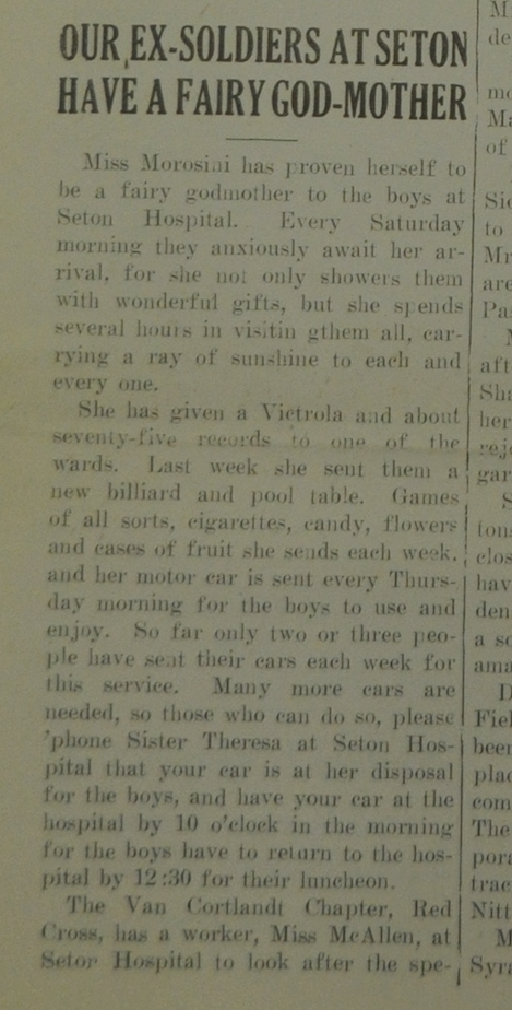
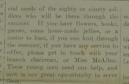
It is also worth noting that soldiers were treated at Seton Hospital, where Seton Park and the Whitehall building are today (June 1921 Riverdale News):
Here is the link to the News 12 story if you missed it:
While I do not remember it, we discussed it earlier and you can find the topic in the below link:
https://kingsbridgehistoricalsociety.org/forums/topic/old-bridge-tavern/
Do you remember anything about it?
Thanks for the info, Peter. That would have been a real game-changer for local history–to have that house as KHS headquarters. My mother was born in The Bronx in the 40’s and she has VERY strong feelings about Robert Moses (mostly about the Cross Bronx Expressway). Yet another reason to be angry at Moses.
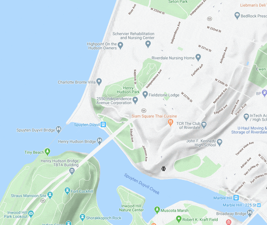
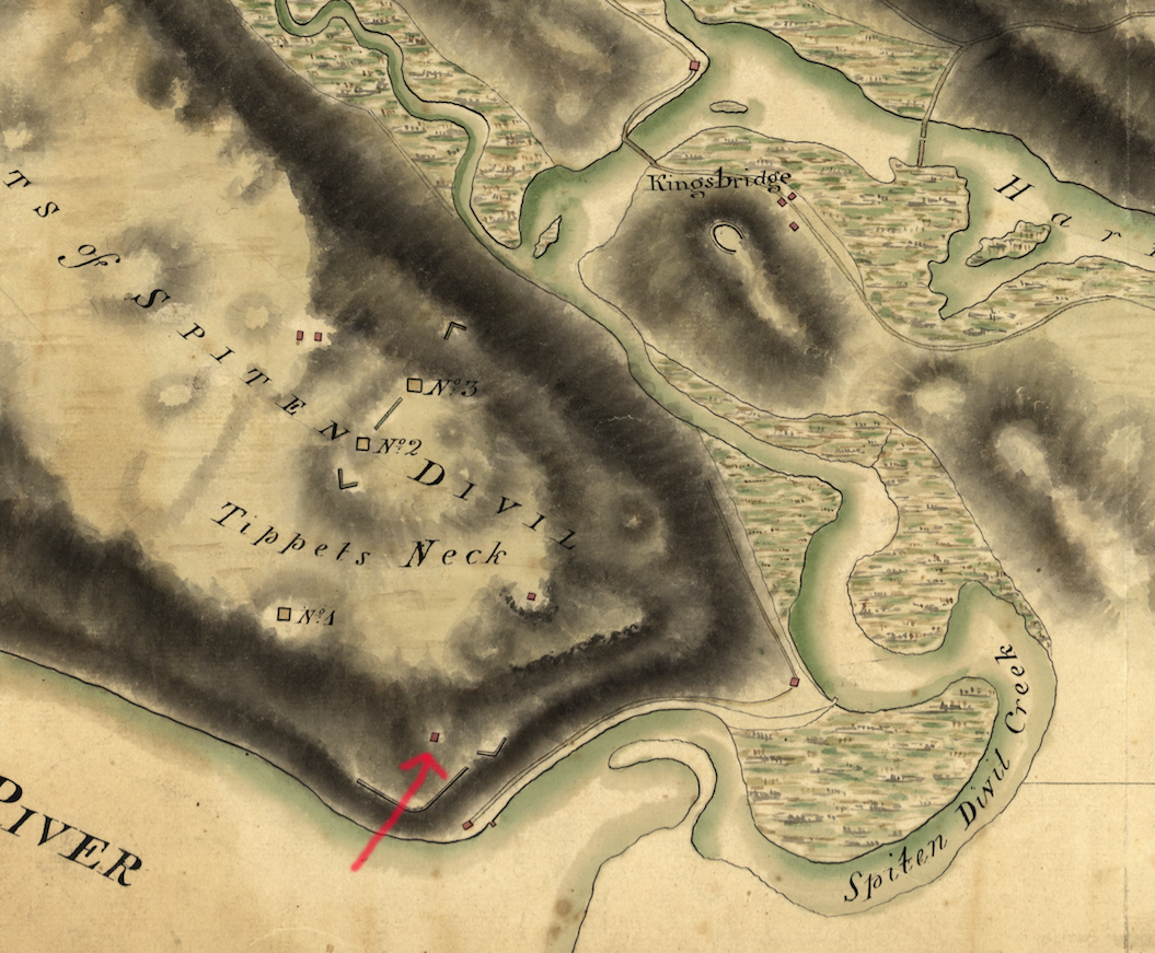
Yes, my understanding is that the house stood where there is now a utility shed/bathroom building by the baseball field. The below animation shows where it was. There is a contemporary Google map there showing the park, an 1885 map with the Johnson house labeled, and a map that I made depicting the area during the Revolution (The red square on the map represents the Berrian House).
If you want to fool around with my map program the link is here (although it is still a work in progress).
Here you can see the house on a map from the Revolution that is in the collection of the Library of Congress:
I just transcribed and uploaded another of J.B. James recollections of old Riverdale, Kingsbridge, and Spuyten Duyvil. I included a bunch of great photos too. It has some interesting stuff about how horrible the trains were to ride in the early days. It also contains a lot of info on the colonial-era houses of the neighborhood (a few of which I referred to in this thread). It is amazing how many of them survived the Revolution only to be torn down in the 20th century. There is also a interesting nugget of information at the very end concerning a burial ground for enslaved people in Van Cortlandt Park. According to James, “a great number of skeletons of former slaves of the Estate were unearthed.” This is the first time I have ever read an attempt to describe the number of skeletons that were exhumed when the railroad was built.
June 20, 2020 at 12:28 am in reply to: Historic Black Kingsbridge 1698-1850 – A Community Revealed in Documents #1479As a Juneteenth update, I have found a few more things since my article about the enslaved people on Van Cortlandt Plantation:
1) The date in the article’s title, 1698, comes from the first record that I could find indicating the presence of enslaved Black people here. Since writing the article, I found an earlier record in the estate inventory of George Tippett, who lived near today’s Van Cortlandt Lake:
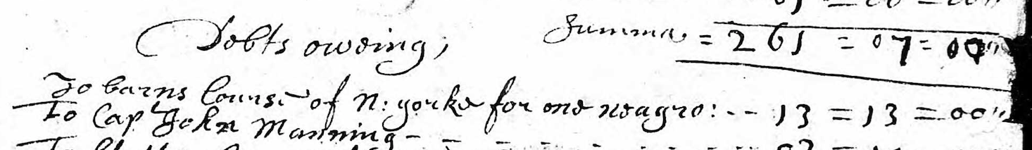
George Tippett left a debt to “Barns Course of N. yorke for one neagro.” The date of this estate inventory is 1675.
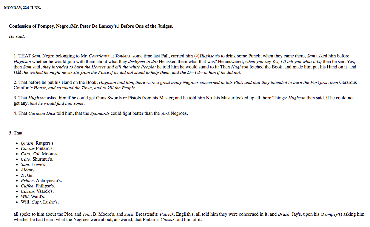
2) I also found a reference to an enslaved man named Sam, who was held by Frederick Van Cortlandt–the first owner of the Van Cortlandt House in the park. Sam was caught up in the slave rebellion of 1741 in New York City. The story of what happened during the rebellion is quite complicated as the subsequent trial turned into a witch-hunt. Historians are divided as to what extent the rebellion plot was real or imagined. The published manuscript reveals that Sam confessed to recruiting other enslaved Black people in the plot. Many of the alleged plotters were burned at the stake or gibbetted. Sam was exiled to the island of Madeira as punishment. Below are some sections of the manuscript that was published after the trial. For an exhaustive history of this rebellion and trial read <span style=”text-decoration: underline;”>New York Burning</span> by Jill Lepore.

Another old house that J.B. James refers to in his memoir is the “Samler House.” In 1935 he wrote:
Another old timer was the [S]amler house, at the junction of Albany Post Road with Broadway at about 254th St. The house was in the old Dutch style, with a long sloping roof covering the porch. A grape arbor, with a brick path ran from the house to the road. The grounds were 17 acres of hilly, picturesque land, and a row of fine old cherry trees stood along the road front. Many a feast I have had on their fruit. The farm had several large shag-back hickory nut trees, a great rarity now. These nuts are the finest flavored of any nut that grows. The trees were cut down for firewood before we left Riverdale. The old house still stands, but was moved westward about one block and fitted with modern improvements.
I have seen references to this house before. The Reverend Tieck mentioned it only briefly on p. 154 of Riverdale, Kingsbridge, Spuyten Duyvil:
About 350 feet north by west of the point where the Henry Hudson Parkway crosses Broadway stands a very old white frame dwelling, the Samler house, now slightly west of its original location.
So the house was still there W. 254th Street and Post Road when Tieck was writing–in 1968.
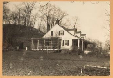
There are photos of the house at the NYPL and the New York Heritage site. This one was taken in 1924.
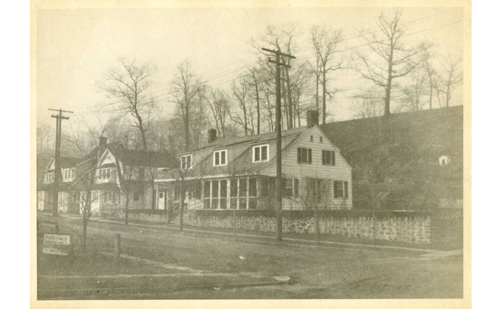
It does have the classic look of an old NY Dutch farmhouse from the colonial period. This is that same view today.
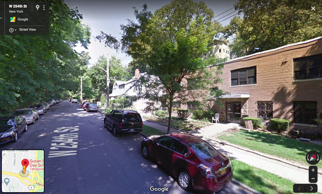
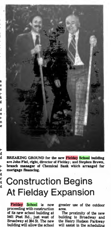
There is a charmless looking concrete box on the site now but the same single family homes can be seen in the distance. I found out that this concrete building was built in 1978 to house the “Fielday” preschool:
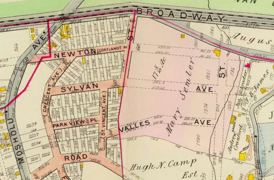
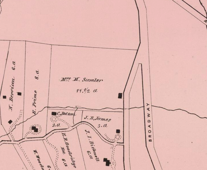
Both James and Tieck referred to the Samler House as “old” and state that it had been moved but offered no dates. I got curious about the history of the building. This very cool 1907 map of Riverdale shows the house on a plot shaded pink and labeled “Mary Semler.” This is before it was moved–fronting on the Albany Post Road–not far from J.B. James own house to the east and it shows the Samler farm as being 17.5 acres.
The property was sold not long after that map was made. The below map (estate sale map of the Samler farm) shows where the house was in yellow and where it was moved to (marked with a blue asterisk).
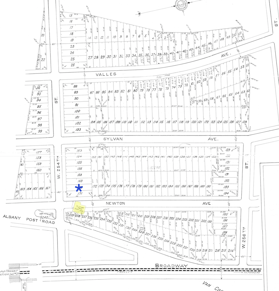
So the house was not moved very far at all. Who was Mary Samler? Googling around reveals that she was the daughter of George Washington Hadley, which explains a lot. The Hadley family’s connection to this neighborhood predates the Van Cortlandt’s presence here. In fact, the Van Cortlandt House probably sits on land that previously belonged to the Hadleys. Digging into Mary Samler’s ancestry a little I found that she was a descendant of many of the local colonial era families (Tippett, Betts, Warner, etc). So it at least seems to offer the possibility that the house was indeed “old” as J.B. James and Rev. Tieck suggested.
Cross Checking the location of the house on an earlier map indicates that the Samler house was just north of a stream that fed into Turtle Brook (an old stream that crossed the parade ground of Van Cortlandt Park):
Now check out a zoomed out view of the same location on this 1781 British Intelligence Map:
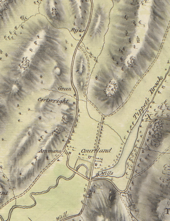
The road that runs north to south down the middle is the Albany Post Road. “Courtland” is the Van Cortlandt House. The house labeled “Green” is THE Hadley House that still stands at 5122 Post Road. To the north of that is a house labeled “Ryar” that stands just to the west of the Albany Post Road and just north of a creek–a dead ringer for the location of the Samler House.
If this is the same house, who was “Ryar?” This part of Riverdale from 1693 until the Revolution was part of Philipsburg Manor. In 1693, the land was granted in a royal proclamation to Frederick Philipse, who became “Lord” of the manor. During the Revolution Frederick Philipse III, who was the Lord of the manor at that time, paid a large price for his loyalty to King George IIII. His lands were forfeited to the new American government and they were sold by the Commissioners of Forfeiture in 1785-1786. Before then, the manor was divided up and farmed by tenants, who paid annual rent to Philipse. Ryer was one of those tenants. The Westchester County Archives has the records of the sales that occurred under the Commissioners of Forfeiture and this is the relevant one:
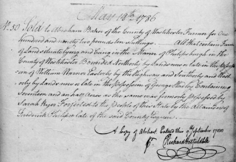 It reads: “No. 50 Sold to Abraham Baker of the County of Westchester Farmer for One hundred and ninety two pounds ten shillings. All that certain Farm of Land situate lying and being in the Manor of Philipsburgh in the County of Westchester Bounded Northerly by Lands now or late in the possession of William Warner Easterly by the Highway and Southerly and Westerly by Lands now or late in the possession of George Hadley Containing seventeen and a half Acres as the same was formerly possessed by Sarah Ryer Forfeited to the people of this State by the Attainder of Frederick Philipse late of the said County Esquire.”
Note that the acreage of the farm is the same as it was in the 20th century–17.5 acres. Other than the above document it is difficult to figure out what members of the Ryers family were living there before the Revolution. They were a Dutch family, which means that had different naming conventions and their ancestry is confusing–but it explains the Dutch colonial architecture of the Samler House.
I could not figure out when the Samler House was torn down but it had to be before 1978 when the Fielday School building was built. I found a reference to the address, 225 W. 254th Street, in this 1963 blurb but other than that, nothing in the Riverdale Press:
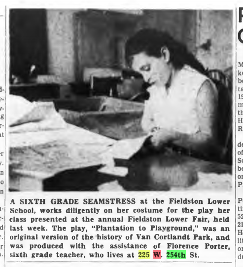
I find the idea of this teacher, Florence Porter, living in a local historic house and teaching local history fascinating. I wonder if she knew the history of the home that she lived in.
I also wonder if the house was torn down, burned down, or what. If local historians were vaguely aware of its history, I wonder if anyone opposed its destruction.
Thanks for the info. Definitely good to have a copy of the Riverdale Historic District document. As for the house, I have to say it sure beats a lot of the McMansions that were recently built in Fieldston–and what a view! Anyone want to buy it and donate it to the KHS as a new headquarters?
J.B. James’ memoir includes information on another old house in the area:
There was also a very old farm house on the extreme southwest corner of the land, now the grounds of the Colored Orphan Asylum, which was run for many years by a Mr. Whitney as a boarding house. This was also destroyed. It may have been the original Ackerman house, but I think it was the old Warner house.
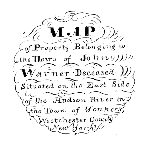
If JB James remembers this old house, there is chance a photo of it could be found. And if it was the original Warner house, it would be very old indeed. Who was Warner? There were generations of Warners that owned a great deal of property in this part of Riverdale. But before they owned the land, they were tenant farmers renting the land from Frederick Philipse as this part of Riverdale was part of Philipsburg Manor, which stretched from here to the Croton River. John Warner was a capable Patriot militia officer during the Revolution. He served as 2nd Lieutenant and later as Captain of the South Yonkers company of militia that hailed from this neighborhood. He was from the 3rd generation of Warners to live in the neighborhood. His father William and Grandfather Charles both farmed this same spot. After the Revolution, Frederick Philipse’s property was seized by the state and the Warners purchased the farms that they once rented.
According to JB James, the house was on the grounds of The Colored Orphan Asylum, where the Hebrew Home is today on the banks of the Hudson. According to this map from the Revolution, there was a house belonging to Warner on the banks of the river:
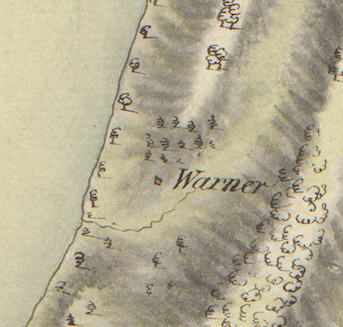
The above snippet shows the house just north of a stream feeding into the Hudson. A rarely seen property map from 1837 gives the area in greater detail.
The slider on the top right adjusts opacity and you should be able to zoom in.
The southern edge of this property borders on the property that is depicted in my previous post (the map with the Henry Atherton estate house that is currently for sale). The southwest corner of this map fits like a puzzle piece into the northwest corner of that map. This map is dated 1837 and includes the following label:
The notch of land on the southwest corner gets its shape from a stream. I believe this is the same stream that is visible in the map from the Revolution. A little bit to the north you will see a “Dock” and three “dwelling houses.” One of these is the house that J.B. James is referring to and they indeed belonged to the Warners. This land is currently on the grounds of the Hebrew Home. Interestingly, one of those houses seems to have a similar footprint to an existing building. It would be interesting to see if photos from the days of the Colored Orphan Asylum could be found to reveal what these old houses looked like.
The property map reveals some other interesting things. Any local maps from this period (1st half of the 19th century) are very rare. To my knowledge, there were no commercially published maps of the area in this time. You can see that there is a bit of land that juts out into the Hudson today in exact same spot where the dock was located. You can also see that part of Palisades Avenue was indeed a very old road. You can also see the “quarry” labeled on the map where the Skyview apartments are today. I found the will of John Warner and he was convinced that this quarry was going to yield a fortune.
I am trying to put these property maps together to make a composite map of Riverdale for this time period but it is loading very slowly. I put the Atherton map and the Warner map together here if you are interested and patient enough for it to load.
I have been checking out the archive that Alan linked to above. Every time I look I find more images that I have not seen before partly because they are often not labeled correctly. The image that he posted of “Godwin’s Island” is labeled as “Small unidentified bridge [over Westchester Creek?], Bronx, N.Y. [?], undated [c. 1897-1918?].” In reality this was at today’s W 230th St. and Broadway.
The great thing about these photos is that you can zoom in on them forever. Check out this one I found of the King’s Bridge that was also incorrectly labeled:
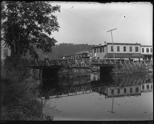
Check out how close up you can get with zooming:

The level of detail is pretty amazing. J.B. James refers to the oysters you could get in Kingsbridge and there they are at “Liesler’s Fancy Groceries and Delicatessen.”
You have a real gift for finding photos, Alan.
I cannot believe you found a photo of Warner’s Store. I have been looking for one for YEARS. That store was the center of the neighborhood of Mosholu. The owner, Matthias Warner, also ran the post office and I’ve seen his name as a witness to legal documents of the Van Cortlandt family. One thing I wonder is if this is the same Warner family that lived in North Riverdale during the Revolution and served in the local militia. I imagine it is although I have never made a genealogical connection.
The below painting of the Van Cortlandt House in the 1840s hangs in the gift shop of the Van Cortlandt House Museum. I have always been curious about the buildings in the background. On the far left there is a columned building that would be somewhere just west of Broadway, perhaps on the Albany Post Road. It seems to have the same general shape and neo-classical look as the Warner’s Store photo but it looks like it is farther north.

On the right of the house are the barns that are on the southern end of the parade grounds. Between the barns and the mansion are some buildings that were out on the parade ground. I remember reading that there was a farmhouse among them and it would not surprise me if the “sheep barn bridge” is out there as you suggest.
As for the tracks on Broadway, I somehow missed the electric lines overhead–good catch.
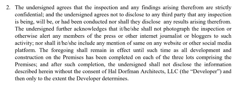
The part that still does not make sense to me is what the developer and owner were actually afraid of. Even if we were to find George Washington’s dentures buried on the lot, there is no law or ordinance that would have prevented them from building there.
I was the one who voluntarily offered to sign a non-disclosure agreement so that any findings would not be revealed until after construction was completed. You would think that would satisfy the developer and his attorney. But instead they countered with multiple agreements that amounted to a gag order–a lifetime ban on ever discussing what was found without the consent of the developer. That fact alone shows that they in fact knew the fort was there but wanted to make sure know one else would.
The fact is we were not treated in a honest and straightforward manner. The owner, Martin Zelnik, claimed in the Riverdale Press that:
“If it’s just a question of getting publicity or being able to photograph something for documentation, I don’t have a problem with that,” he said. “It was never raised with me. If they wanted a photograph an arrowhead if they found one, God bless them. I’m all for historic preservation.”
He added:
“I thought (the agreement) was fine,” Zelnik said. “But the next thing I know, he’s going to the newspapers making claims that I’m totally unaware of.”
I found it incredibly dishonest on Mr. Zelnik’s part to say in the press that he is “all for” allowing a dig for “publicity” and that photography would be okay with him. The documents sent to us by the developer’s attorney expressly forbade the very things he said he was “all for” and he was a designated signatory on the agreement. They sent us agreements saying one thing and then said something totally different in the paper.
This is the provision on the agreement that stated that we could be prohibited from publicizing the dig and that photography would not be permitted:
 This is Zelnik’s signature line on the Non Disclosure Agreement:
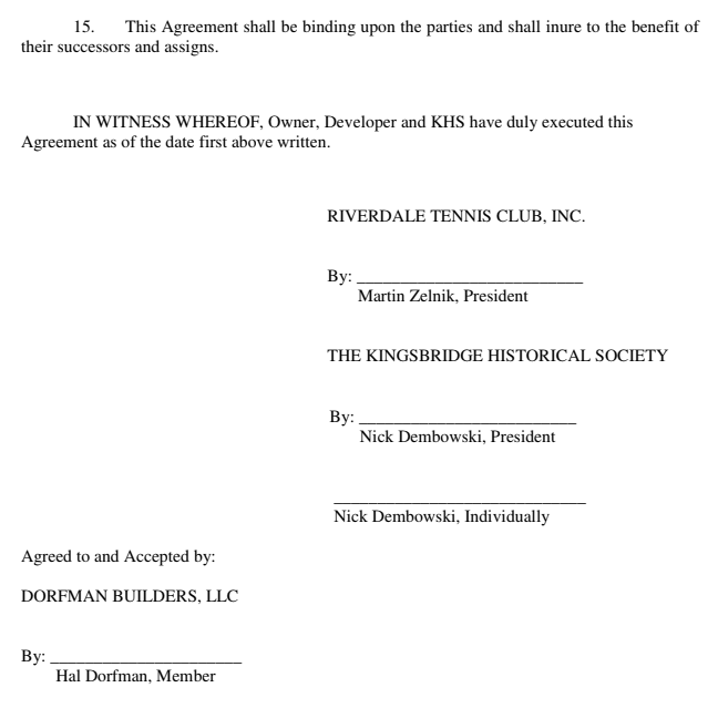
No, they did not get involved in any serious way. I got one or two phone calls from political staffers but no follow through.
Nice find.
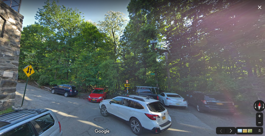
In the first photo that you found you can see a retaining wall that is still there. It is the wall for Bertino Memorial Field at the Riverdale Country Day School. This Google street-view shows the same spot (note the wall on the left):
It looks like J.B. James beautiful childhood home was knocked down for the construction of the Henry Hudson Parkway–right around the time he wrote this memoir. Explains some of the nostalgia.
-
AuthorPosts