Forum Replies Created
-
AuthorPosts
-
Nick – Think you may have nailed it. The maps and documents all pointing to Muscoota with Mosholu being a derivation or mistaken spelling of it all seems to fit. I’ve seem long held beliefs on the origin of my own last name being proven wrong with further research and using maps at that. Way to go Nick, nice work and research ‘connecting the dots’ on the origin of Mosholu.
Regarding naming of Fort Independence Ave in Spuyten Duyvil. It does go back to the misplacement of two Ft Independence’s on the British 1776 map. Another reason though for the two Fort Independence’s is the confusion on which hill it was located. Tetard’s Hill or Tippett’s Hill, both of which the Americans built forts.
Nick would agree the view is north west. It looks like the Van Cortlandt or Riverdale Ridge in the distance. Perhaps even part of the Palisades at top right which all would have all been very clear at that period. Don Troiani does some excellent historic painting. A modern day John Wards Dunsmore. He does detail research before he starts a painting. He also collects original uniform, swords and articles to use for accuracy in his paintings like Dunsmore. I once contacted him back in 1980s to try get him interested in painting the fort. He lived at that time up in Connecticut and was interested in coming down to view Fort #2. Not sure if he ever did.
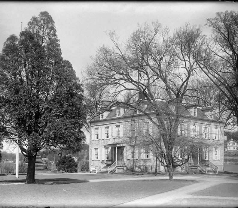
Two additional items of interest is the old gas tank in far distance located then at at the foot of the Fordham landing at the 207th Street bridge. Also in the distance are 3 of the Fordham Hill Apartment building complex then under construction. ( you need to enlarge the photo to see them clearly)
Of even more significance is the street shown, Marble Hill Ave, is also named The Rev Dr William A Tieck Way – Founder and first President of the Kingsbridge Historical Societ. The KHS initiated the street naming process and helped its passing by the City Council.
PS- The photo is also likely a RCSA photo – ‘right click save as’ internet find ! A Good one.
Can’t help on the original location. Don’t believe I’ve ever seen a description of the location. Regarding your first photo. The large building at the top center of the photo is /was the Ben Riley’s Arrowhead Inn a popular nightclub that was open here until 1940. There were actually a few Ben Riley Arrowhead Inns. First up in Saratoga 1890s, then 177th & Ft Washington Ave in 1908 then move to Riverdale then last one in Yonkers, Tuckahoe Rd. He died in 1944 in a fire where he lived above his Inn in Yonkers. Some of his friends and guests were Diamond Jim Brady, Lillian Russel, W.C.Fields.
Dr. Tieck’s book should be available as a reference book at the Spuyten Duyvil library or Riverdale Library. It is usually not on the reference shelf anylonger as it has gotten stolen many times. Usually if you ask the librarian they have it behind the counter that you can read while at the library.
Regarding information on the Rosa Bonheur or McKelvey’s I agree with Nick that while a beautiful and interesting designed building it was not very old. Especially considering that when the Kingsbridge Historical Society was founded back in 1949 or when the book was published 1968, it was a relatively new building. Much as we think of today the The Whitehal on HH Pkwy or the Century.
Interesting article, and good research making the connection between the names and documents and relating it to our area as so little is know of the personal life of early settlers.
Regarding the use of the word wench. Dictionary indicates it means as a NOUN (archaic) -a girl or young woman.
synonyms: young woman · young lady · miss · lass · lassie · colleen · [more]So taking it in the context of the times might not sound as bad as we think of it today. Still the sad truth this woman was his slave. The interesting piece is that Robert Brown assumed the responsibility and welfare of his children in his will. We still have much to learn about the relationship of owners and slaves. I’d be interested in what Mrs.. Brown felt about his having 2 children and not by her?
January 10, 2019 at 1:59 am in reply to: Kingsbridge Article with Nice Photos from Municipal Archives #827The Dale theater was actually located where the Maga Deals store is located in the picture shown above. It was a family movie theater but at the end of its life turned into showing ‘Art’ movies and X-rated for few years before it closed. It was a pretty small theater compared to the RKO Marble Hill theater on Broadway and 232nd st.
January 10, 2019 at 1:55 am in reply to: Kingsbridge Article with Nice Photos from Municipal Archives #826The Velodrome was East of present day Target store and was used for professional bike races. The velodrome opened May 30th, 1922 and cost of a quarter-million-dollar for the bike track, built to hold 16,000 fans. It also was used for 6 day bike races and boxing matches. it burned down August 4th, 1930 .
I can see the VC Mansion in the second map. But what intrigues me are not only the other buildings in the upper map#3 but the rather large ponds or lakes shown in the middle of today’s Parade ground in map #3 . You can see Turtle Brook coming down between Vault and present day Broadway but these ponds are new to me. I am wondering if these building are not only houses, out buildings and barns but perhaps also used to store Ice? There is a rather long structure that looks like a half bracket or a capital E going east and west below the buildings and ponds and north of the Mansion.
April 22, 2018 at 3:04 am in reply to: The Enslaved People of Riverdale, Kingsbridge, and Spuyten Duyvil #448When one is researching the 1790 and for a few federal census records following the information was taken in the order locations of the homes. So you can follow old maps and follow the trail of the census taken. In subsequent years following the 1790 census if a new home was built unfortunately it was added to the end of the list breaking with the sequential order of the earlier census. If you follow the link provided above to see the 1790 census records about Kingsbridge remember to search on yonkers at the search line at the left.
April 10, 2018 at 4:34 am in reply to: Saving the Historic Gravestones of the Berrians in Van Cortlandt Park #435I conducted a survey 25 or more years ago with a few members of the KHS. We plotted on graph paper where we found remnants of headstones. Believe we counter approx 35. Would need to find the chart to verify. But when Woodlawn cemetery was open in 1866 many families elected to move and re-bury their dead at Woodlawn. But not all families did so. So besides the two larger Berrian headstones that were intact up to the early 1980s there are many other burials still at the Kingsbridge burial grounds including the Berrians.
April 5, 2018 at 2:58 pm in reply to: The Enslaved People of Riverdale, Kingsbridge, and Spuyten Duyvil #408There was an African slave burial plot for the Van Cortlandt family slaves that was situated adjacent to and east of the Kingbridge Burial grounds in Van Cortlandt Park just west of the lake and old Putnam RR tracks. There were no known headstones but the placement of field stones to mark the locations of burials. It is thought that this burial site was mostly or totally destroyed by the cutting through for the old Putnam RR line spur to Yonkers. There is no marker on the site today for either the Kingsbridge or African burial grounds. A number of years ago the NYC Parks dept had plans to install a dog run on the site of the African slave burial location adjacent to the Kingsbridge Burial grounds. After the KHS informed the Parks Dept and CB8 of the historical and sensative nature of the site the plan for the dog run was abandoned. As with many NYC Parks Dept plans regarding historical sites there is little concern, planning and research done when money is offered for projects usually by local politicians who should better.
I believe the house or Inn that Sarah kemble Knight mentions stopping at 10 miles out from NYC and 5 miles from the Kings Bridge was likely the Blue Bell tavern located down in Washington Heights about 181 St and Broadway. A famous tavern and location depicted in many paintings and drawings. A good one can be found in the old Valentines Manuals.
I would guess this was an idea proposed by the real estate developer which would increase the value of land and lot in Riverdale. Some of the earlier plans for the Henry Hudson Memorial Bridge did have the bridge East of its present location. That is East of the Inwood Ridge keeping it lower but crossing over to where the Major Deegan highway is today. This was proposed to keep Inwood natural forest and the Riverdale Ridge free of a major highway.
But the builder Robert Moses did care that the HH Pkwy would cut right through the Inwood ridge and divide Riverdale much like the other Moses who parted the Red sea Robert Moses forced the Bridge and HH Pkwy and parted the communities. More detail information on the building of the HH Bridge can be found in Robert Caro’s excellent book the Power Broker.The Century house was the ancestral home of the Nagle Family located down in today’s Inwood at 213th Street. The term Century House at ‘Spuyten Duyvil’ was the general reference back in the 18th and 19th Century for a much wider geographical area than it refers to today. The house faced East toward the Harlem River. The house was built by Jan Nagle in 1736 and was torn down by the City in 1900 for street opening of 213th street. For more detail and photo’s on the Century house read Cole Thompson’s article at this link http://myinwood.net/inwoods-century-house-an-early-preservation-attempt/.
The Waldo Hutchins mansion fronted on W 238th Street facing south. It was located on what is today’s Manhattan College ‘Overlook’ dorms and bit further west up hill the Irish pub An Beal Bocht.
Interesting quote especially the mention of 1000 killed at Battle of Pells Point which is always debated. Was the quote from a diary if not can you share where you found it? Nice find.
-
AuthorPosts