Forum Replies Created
-
AuthorPosts
-
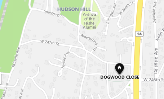
Great use in referencing old deeds to find area namings. Of interest is the reference to a Doggwood Brooke in the 1685 deed to Frederick Philipse . Today just up the road East from Adlerbrook is a 50 Townhouse complex built in 1953 called Dogwood Close. While many local area names are real estate sales names (eg. Riverdale, Marble Hill, Fieldston) that have no real historic precedent its good to see that some real estate and builders did perhaps do their research before naming these streets and buildings in this area ( Hadley Ave , Adlerbrook Rd, and Dogwood Close )
Sadly during the Bronx is Burning era the Plaque was stolen.
Yes I too have never heard of a mass hanging in Van Cortlandt or frankly any location in Amer Rev.
30 hanging in one place would be very a large number. In army terms it would be a platoon size group. For comparison there were only 22 Hessian killed in the Battle of Trenton and 30 Americans in the Battle of Bennington. More like a rumor spread by the Van Cortlandts to keep the cowboy and skinners away or today’s Beware of Dog sign.
In addition the quote “that James Van Cortlandt died in his early 50s, a typical age at that time in history is a generalization. Many early Dutch lived well into their 70s and 80s, same for those of the Amer Revolutionary period. In the same vane that those back then were short. George Washington was 6 ft 2.
There was another whale sighting in the Hudson River in 1647. Long before Melville wrote Moby Dick there was a white whale spotted in the Hudson River at Beverwyck, present day Albany by Anthony deHooges. Antony de Hooges arrived in 1641 to served as business manager of Rensselaerswijck, the patroonship owned by Kiliaen van Rensselaer. De Hooges recorded the colony’s business and some personal observations in the Memorandum Book. This same person would be remembered by mountain named Anthony’s Nose. The mountain is located at the East end of the Bear Mt bridge. This same Anthony also happens to be my 8th Great Grandfather. I am happy to state this is one physical characteristic was not passed along to me.
Earlier in 1641 Van Rensselaer also hired Adrian vander Donck, a young man from Breda who had studied law at Leiden. Van der Donck would serve as officier or schout in the patroonship. A schout was a man who enforced patroonship policies and regulation. He too as noted earlier saw whales in the Hudson River.
Anthony DeHooges wrote in his papers that
“A certain fish appeared snow-white, round
of body, and blew water up out of his head.” – From the memorandum book of Antony de Hooges, 1647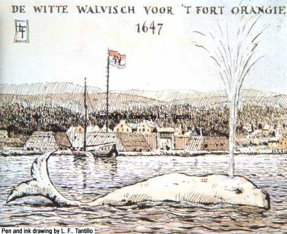
In the early spring of 1647, an unusual sight startled the inhabitants of Rensselaerswijck. As they watched from the shore in “great amazement,” a mysterious creature of “considerable size” made its way up the river and back whence it came. Several weeks later, a similar creature appeared, “[blowing] water out of its head like the one before.” Eager to document the unusual events, Antony de Hooges, secretary of the patroonship, recorded his thoughts in his memorandum book among the humdrum proceedings of ordinary business. De Hooges speculated about its meaning, only God knew, and the possible connection to the first thunder and lightning of the year, which occurred on the evening of the second sighting. The memorandum book is in box 31 of the “Van Rensselaer Manor Papers” held by Manuscripts and Special Collections of the New York State Library.
You can read the full text on the New Netherland Institute website -https://www.newnetherlandinstitute.org/files/2713/5543/9527/DeHoogesTranslationFinal.pdf
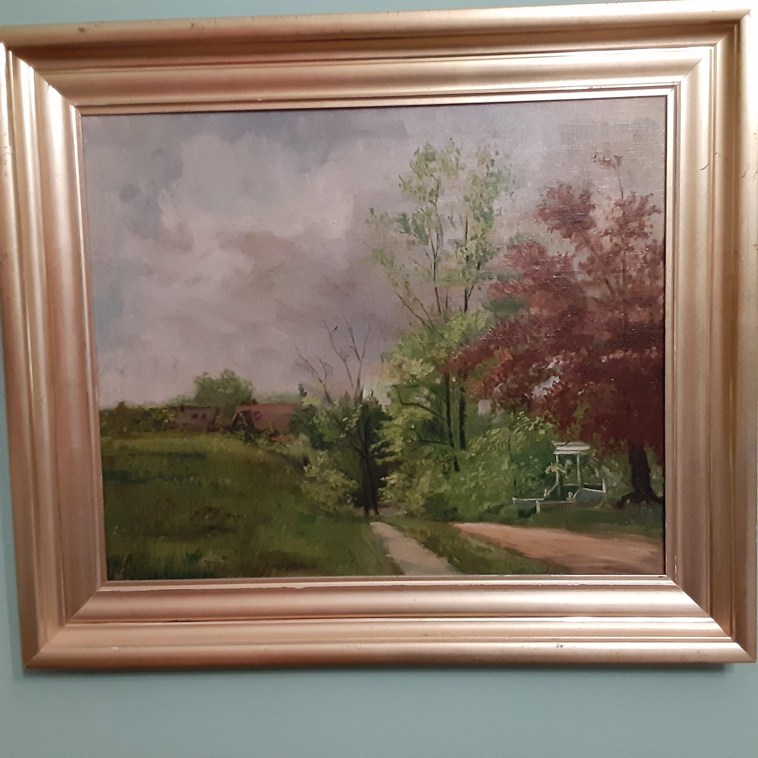
Jean Knowles (1908-1988) was an early member of the KHS and its long time corresponding secretary. The photo above was published in Reginald Pelham Bolton’s book Relics of the Revolution (1916). Jean is the little girl sitting on the stack of canon balls holding a bar shot. The gentleman at the far left leaning on a shovel is Reginald Pelham Bolton who was an historian, early archeologist, writer, leading engineer and an expert on native American and American revolutionary historic sites. The large canon ball atop of the pile is actually a mortar projectile that is owned by the KHS and is in the cellar of the Van Cortlandt Historic House. The KHS also has a collection of these same canon balls, bar shot and sliding bar shot which is a unique American design. In the John McNamara interview with Jean she describes Fort Independence and Giles place when her family moved to the area right before WWI. Below is a painting by Charlotte Livingston (1898-1991) an early member of the KHS and Trustee and friend of Jean Knowles. The painting was painted in 1919 looking south of Giles Place towards Fort Independence street. The field where the canon balls were found and the Forts location was to the left in this painting which was painted only 4 years after the discovery of the canon balls. Ironically it was painted when the Spanish Flu pandemic of 1918 was starting its second wave. So while we can’t experience this bucolic Bronx scene any longer sadly we will experience our own second wave of the Covid-19 Flu pandemic of 2020.
 November 26, 2020 at 9:39 pm in reply to: Old Marble Hill Business – Schumacher Bros. on 225th Street #1765
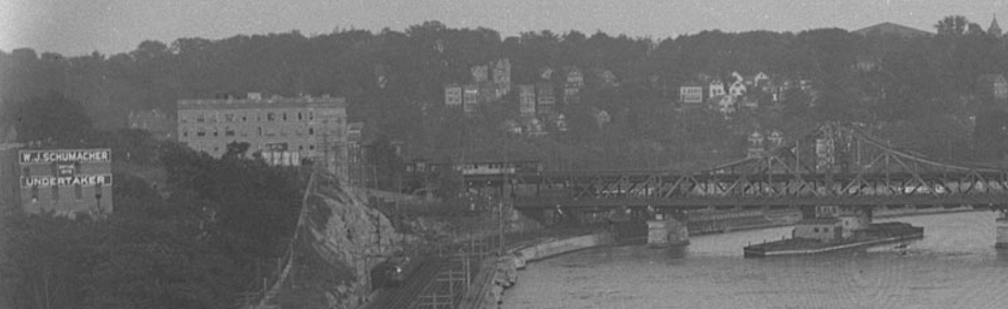
Alan – thanks as always for these great photos. I enlarge one, below, with a closer view to show the top of the Armory at the top right (dark triangle) built 1912-17 and the Schumacher building at left. Thanks again Peter
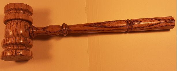
Regarding the old Berrien-Johnson house. The only known artifact that I am aware from the old Berrien- Johnson house is a oak gavel made from one of the beams from the house. The gavel was made for the Kingsbridge Historical Society I believe by George Younkheere a founding member of the KHS and owner of a lumber store that was once located about 235th and Bailey Ave. The gavel is part of the KHS archives.
The picture titles in the collection 0f the MCNY may not be incorrect. Randall Comfort wrote a number of books and articles on the Bronx , one on our area ” The Great North Side , or Borough of the Bronx, 1897)”. He also did extensive early photographing of old buildings in the Bronx that were being lost to history Ca. 1890-1910. From Randal Comfort’s article – Mansion of the Old Bronx . from the 1922 H.C. Brown’s Valentine Manual he wrote:
The Bowie Dash Mansion
High on the hills among old Riverdale’s most picturesque glades, the old Bowie Dash Mansion fairly overlooks the world. Dash’s Lane, narrow, steep and winding, which in days past formed the only means of access to this residence, has yielded tot he broad and beautiful Spuyten Duyvil Parkway. What a contrast! (PO – Manhattan College Pkwy today.)
Styled “Upper Cortlandt’s” to distinguish it from “Lower Cortlandt’s” in the valley below (PO – the ‘Lower” VC Mansion/VC House Museum is the one in the park) , the square stone Dash Mansion is said to have been often visited by General Sherman, one of the relatives of the family, while we are told that the late Theodore Roosevelt often played there when a boy.
The quaint gardener’s cottage on the estate far antedates the residence itself, while close by, between the years of 1776 and 1781, was an extensive Yeager Camp. ( PO- this Hessian Yeager camp was dug by Reginald Pelham Bolton ca 1913-15. It was located approx. at corner of 238th St and RIverdale Ave, upon on the sports field of Fieldston School campus.)
(PO -, So the cottage and what we believed to be the Dash Mansion on Waldo Ave & 238th St is a good chance that Bowie Dash or a member of the Dash family once owned this old ancient Cottage. More research is still needed.)
Thanks for the articles and photos. I totally agree the house was older than 1910. You could tell just by looking at the construction and style. Having been inside a few times there was no doubt.
For anyone doing research on a private house in NYC needs to be aware that the City Real Estate records are notoriously wrong. Many older homes show a build date of 1920 or as in this case 1910. They seem to have been a guess on the part of the records department when the files were created. My own house has a 1920 build date while it can be found on older maps as early as 1884, I still don’t know the actual build date. This is very similar to the Bowie Dash house build misinformation above.
HI Tom – Good point perhaps the canal and bridges was their intent to call them Dutch Garden in association with the Van Cortlandts.
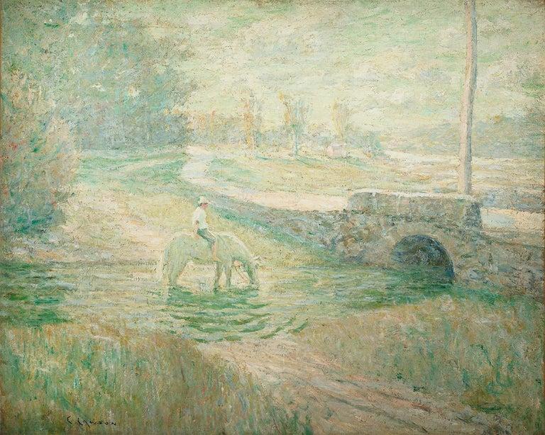
Regarding the bridges. There is a painting by Ernest Lawson (1873-1939), one of the” Eight ” artist, that is possibly a bridge in the Dutch Gardens. The painting is entitled The White Horse. There is no attribution to this site but Lawson did paint upper Manhattan and Bronx in a series dubbed Harlem River School by critics.
I am always amazed how much interest and attention is given to the Dutch Gardens. Built in 1902 poorly and improperly that they had to be rebuilt by 1911. Not much Dutch about it but was built during the Colonial revival period of interest ca 1900-1920s as the 150 anniversary of America Independence approached. By the early 60s the gardens were in decay once again with the west side taken for the 2 pools which again poorly planned and built soon ran into problems. Again a lot of money wasted by another poorly designed and planned Parks Dept project .
Regarding the hill south of the VC Mansion. My thought is that it is not man made or built by slaves or others. The 1781 map indicates a 3 sided deep ridge much as a present day topgraphical map would indicate the same today, steep hillside slopes.. The last glacier created the parade ground by wearing down the Inwood Marble while leaving the Riverdale ridge to the West and Van Cortlandt ridge to the East made of Fordham gneiss.
This ridge is basically the end of the parade ground that was likely eroded by the glaciers movement south and the receding waters, and cut deeper by the water action from Tibbett’s Brook over the centuries. The ‘U” shape and course of the brook is likely due to nature as well. Major storms can and do change the shape of streams, creeks and rivers and in a few cases have changed the directional flow of rivers.
Today the area is reverting back to a more natural state until someone in Parks or Community Board comes up with another poorly designed project to waste taxpayers money.
The force behind the destruction of the Berrian-Johnson house was Robert Moses. Moses had many hats two of which gave him the power to destroy the B-J house. He was the head of the Triboro Bridge and Tunnel Authority and Parks Commissioner. As I understand it his first effort was that the house was in the way for a reconfiguration of an exit from the Henry Hudson Parkway. The other was expanding of Henry Hudson Park. The Kingsbridge Historical Society under its President and founder, Rev.Dr. William Tieck, engaged Robert Moses in requests to save the Berrian-Johnson house and protest. One request was to save the house and use for both Parks Dept use and as a museum for local history by the Kingsbridge Historical Society. It should be noted that the KHS was the only historical society in the Bronx as the Bronx County Historical Society was not founded until 1955.
The KHS’s effort failed and the building was destroyed in 1952.
This is not a unique decision by Robert Moses. When they were building the New England Thruway entrance from the Hutchinson River Parkway the original plans by Moses would have been built directly through the location of the historic Split Rock. Eventually Robert Moses was pressured to change his plans and moved the Exit off the Hutchinson Pky to the New England Thruway. The exit was moved a few yards to the East leaving the Split Rock isolated on a piece of land between a busy exit to the NE Thruway on the west and the Hutchinson River Parkway to the East making it had for anyone to find and visit the historic Glacial erratic and Native American site.
Regarding copies of the Riverdale Press early editions, the KHS has the early decades of the Press in bound book copies but unfortunately with the pandemic the KHS archives are not accessible at this time.
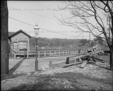
Another very interesting photo is the removal of the Kings Bridge bridge in 1913. It’s a sad fact that the bridge could not have been preserved. The Bronx Historian and author, Stephen Jenkins, who wrote the book The Story of the Bronx had tried to preserve the old bridge back at this time. He was trying to have the bridge dismantled and reinstalled in Van Cortlandt Park next to the mansion. Unfortunately he was not successful, not much has changed in the regarding to historic preservation in the Bronx.
In the photo below notice the horse drawn cart and workers removing the bridge. Coffer dams were built to the east and west to keep out the Spuyten Duyvil creek. View is from south side of bridge on Marble Hill looking North West.
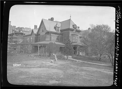
Alan – as they say in football ” upon further review of the judges” you are correct the large mansion in your photo is the Fairchid Mansion while the Claflin Mansion is slightly further back and to the right. I had always assumed it was the Claflin mansion. In Dr Tieck’s books there are a few photo that identify it as the Claflin mansion as we know now is incorrect. Having grow up across the street from the Claflin Mansion/OLA Rectory I never gave it a thought.
I had no idea or heard of the Fairchild Mansion. Interesting it was only on the next block (Sedgwick Ave) from the Claflin Mansion on Webb Ave. The Fairchild Mansion looks to have been were the later John Peter Tetard Junior HS was later built, today the school has a new name.
I had to look up who is Samuel W. Fairchild. He was born in Stratford Ct in 1853 and died on Nov. 13, 1927, at his home, 3001 Sedgwick Avenue, Kingsbridge, at the age of 75. He was a former president of the Union League Club, and at his death, vice president and a director of Fairchild Brothers & Foster, 70 Laight Street. Long an outstanding figure in the manufacture of chemicals, Mr. Fairchild founded the firm of Fairchild Brothers in 1879.
The Claflin Mansion was the summer home of Horace B. Claflin a Dry Goods Merchant who was for a time the riches person in the United States in the 1870’s. His mansion over looked the Jerome Park Racetrack. It was also the 2nd Claflin Mansion as the first located a block south at 197th St and Claflin Ave burned down.
Great photo find Alan. Keep them coming.
Alan another great group of photos and story of the flood and dam breaks. Very interesting new material. Thanks very much. The photo below is from.May 8, 1905 of the Claflin Mansion that is the rectory of Our Lady of Angels church, 2860 Webb Ave. This is the large house shown on the ridge of your initial new photo and the 1902/3 comparison photos.
The destruction of the fort site is a real loss to our neighborhood, NY City and American history. But sadly won’t be the last. Our local elected representatives were alerted to the issue of the building on the historic Revolutionary War fort site. While the owners and builder of the site, Hal Dorfman and Martin Zelnik played dumb and denied there was even a fort on the site. I can only assume they felt intimidated by the imposing and powerful Kingsbridge Historical Society as they turned over discussions to their lawyer who came across as ignorant as the owners on the history of the site. On a phone called their lawyer denied there was even a fort on the site and said since ‘all of Riverdale is historic why don’t you just go and dig your holes some other place’. How can you argue with such logic.
To further show the enlightened and understanding owners we were dealing with they offered that the KHS could dig ONE(1) test hole 2 by 2 by 2 foot deep, just one!. As if by some divine intervention we would be able to pin point the one place on the site that would turn up something of historic interest. It really makes you wonder.
Councilman Cohen was contacted through his office but the calls were more inquisitive of why the KHS interest in the site than of interest in history of the site. I personally spoke with Assemblyman Dinowitz explaining the significands of the historic fort site. He is a born and raised Bronxite said he appreciated history. I’m sorry I didn’t ask what history. I was asked to send supporting background materials which I emailed to his office, then nothing.
The Fort was built in the summer of 1776, visited by George Washington many times and lastly in 1781 with Rochambeau on the Grand Tour of the area. Fort #2 was also known as Fort Swartwout for the leader of the Dutchess County Militia who built the fort.
It should be restated that we fully understood the monetary and business situation entailed in a building project. We were upfront in acknowledging that our intent was not to stop their building but only to ask permission to do a site survey and some test holes. We wanted to especially document the full size and dimension of the fort as originally built before its destruction by the builders. They were going to plow 3 cellars through the site so what damage could we do. We had engaged the help of archeologist and professors from Fordham University and consulted with NYC Landmark Preservation Commission. The property being privately owner there was no leverage the LPC nor our elected officials could do to stop the building as of right. But reaching out to Cohen and Dinowitz to ask if they could talk and reason with Dorfman and Zelnik. That didn’t happen. The history of the fort is not only of locally significant but also nationally important. There are only a few American Revolutionary Forts available for such study and fully intact. The KHS had done a simple one day site survey back in 1988 with professional archeologist, Fordham University and KHS members. We confirmed the site with a survery and resistivity tests and the dig planned last May 2019 was to actually do a larger survey and dig for a week.
But this latest setback for historic preservation in Riverdale is nothing new. Our leaders really don’t care about local history or American history. Basically it doesn’t get them votes or money for elections. And frankly local history is not really appreciated. But they will name a street for someone no one knows.
The KHS has a long history in trying to preserve historical sites but with little success.
1) Dr. Tieck back in the 1950s tried to stop the ‘Power Broker” Robert Moses from destroying the Berrien-Johnson house on Spuyten Duyvil. It was a pre-Revolutionary 2 story stone house approximately where the little park house is today in Riverdale park playground. Moses didn’t care about history and preservation and so it went.
2) Back in 1994/5 the KHS tried to preserve the historic landscape around the Van Cortlandt Mansion from a $1M+ 6 court tennis complex being built next to the VC Mansion. The KHS sued NYC and won the first round with an injunction to stop construction. But lost on appeal which we could not afford to pursue. If your counting KHS now 0-2.
3) Next was to try and preserve the early 19th C mansion built on Fort #1 on Schriever Home property. The KHS request was similar to Fort #2. First we tried to preserve the mansion. When we realized it was to be torn down we asked if the society and professionals volunteers could do an archeological study and dig for a few days. This too was denied and the house torn down and a parking lot built upon the site.
4) Three years ago the KHS tried to get a new dog run being planned on the East side of VC Park in Woodlawn to be relocated slightly south from being built next to a Veterans memorial. A $1M dog run had been funded by Councilman Koppell and planned and sited by Parks Dept. The KHS asked Councilman Cohen’s, to help work with Parks Dept to have the dog run moved a few yards away from the Stockbridge Indian war memorial. Councilman Cohen’s reply was that it was his predecessor Koppell’s project and not his. No thought to the insult to veterans and historical sites he didn’t want to get involved. KHS 0-3.
5) One recent success was finally getting some attention to the broken and deteriorated headstones of Dorcas and Samuel Berrien from 1794/6. These headstones were removed from their place in the old Kings Bridge Burial ground in V.C. Park and dumped next to the mansion by NYC Parks Dept. Yes the same Berrien’s whose stone house on Spuyten Duyvil was torn down by Parks Dept and Robert Moses. They stones are still in disrepair and not sure if they will ever get reinstalled in the burial ground. When fist removed they were in perfect condition. But the KHS was successful in getting a historic signage erected at the Burial Ground site explaining its history.
The destruction of Fort #2 ( Fort Swartwout) is a major lost to American History. It didn’t need to be if our laws, our elected officials and Community Board had more interest in our past. With our 3rd world one party domination in NY political system I don’t have much hope. When we have one party controlling NYC (49 of 52 councilman democratic),the mayor, the Governor, the state Assembly and Senator all of the same party we are not much better than a banana republic with its lack of diversity of opinion and discussions. It’s a political herd mentality ruling.
Dr Tieck said it best 25yrs ago when he spoke at the City Landmarks commission to try and stop the tennis counts at VC Park “ New York doesn’t know what to do with things that are old, including it’s people, tear down Penn station style , rebuild and regret”. The same still holds true today.
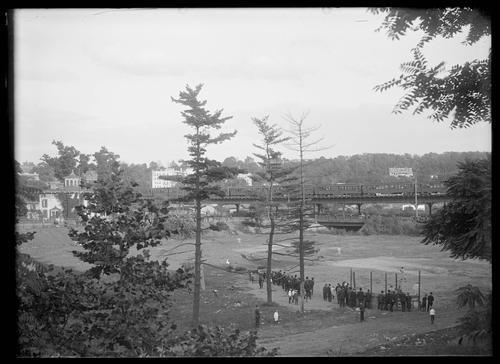
This photo was taken in 1916 showing a baseball field where today is the Marble Hill apt house on the SW corner of 230th and Broadway where today the Kings Bridge historical plaque was reinstalled by the KHS in 1955. You can see the old Godwin Mansion at the left with the copula. To the right you can see the small steel bridge under the IRT train tracks that originally contained the KB plaque. Notice the old trains running across the tracks. This bridge allowed access from the Godwin Mansion to the Godwin Island and further south. If you’re ever in the area look at the steel columns that hold up the train tracks. There is a large gap between two of the columns. It indicates the location of the long lost Godwin Island that was spanned by the IRT trains when built back in 1905. We don’t know who won the BB game.
Thanks Alan – great photo new to me. While it show 1 Riverdale building , even better it shows both the original Kings Bridge location and the historic plaque. Spuyten Duyvil creek was filled in from the excavation dirt when they were building Grand Central. So the photo dates from 1911/1912. The author and Bronx historian Stephen Jenkins tried to save the bridge and have it moved and erected next to the Van Cortlandt mansion unfortunately he was unsuccessful in his effort for historic preservation.
The metal bridge over Spuyten Duyvil creek was used from 1899 to 1931. When the bridge was removed the historic plaque was installed on the Marble Hill Housing apartment at the SW corner of 230th St and Bway on Spetember 24, 1932. It was lost to most until the Kiingsbridge Historical Society and Dr Tieck ‘rediscovered’ it and had it clearned and reinstalled with a rededication on June 25, 1955 where the plaque can still be seen today.
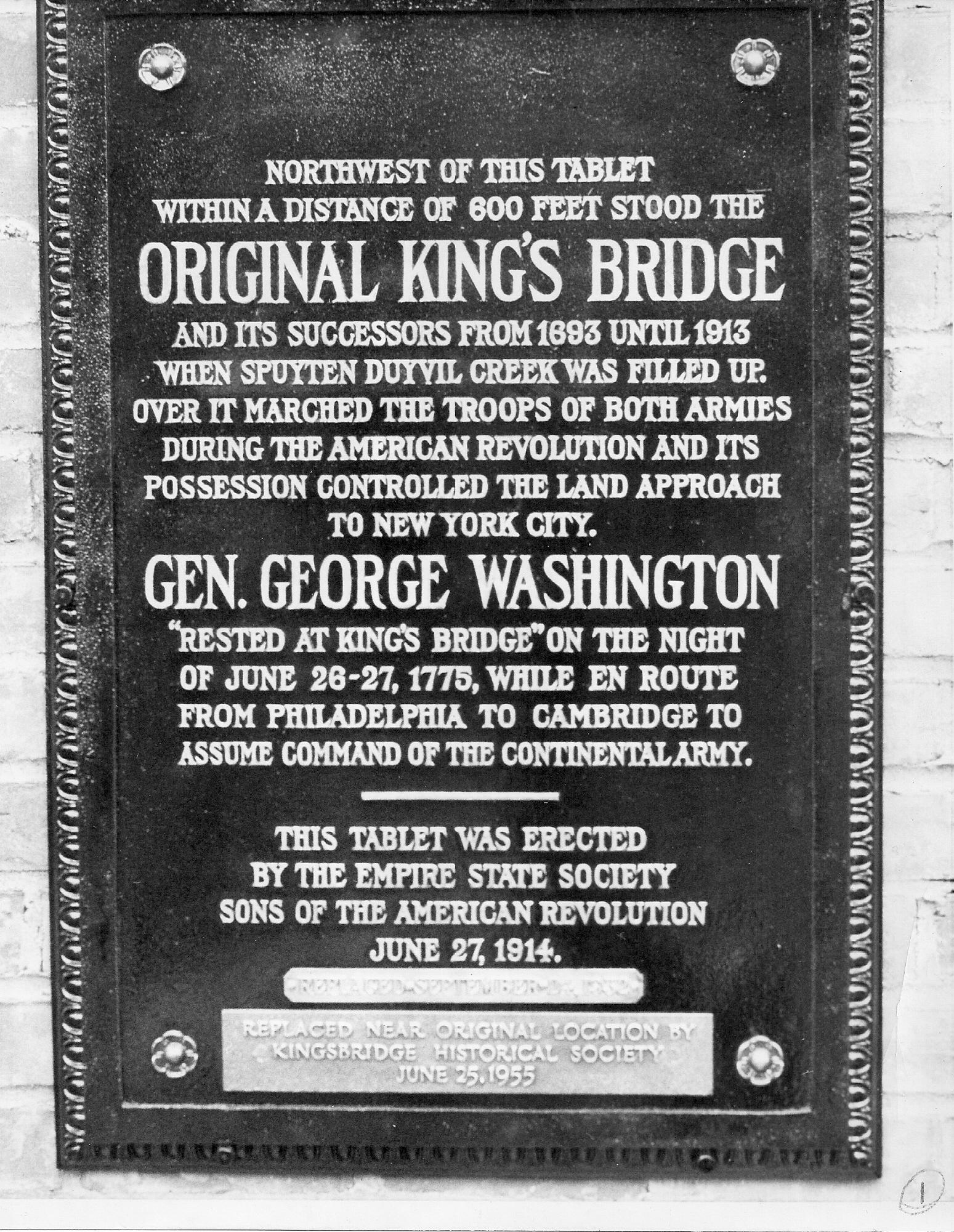
A good source for the above can be found in the book Riverdale, Kingsbridge, Spuyten Duyvil NYC (the red book) by Rev. Dr. William Tieck.
MY guess would be Fieldston. The Fieldston community started about 1913 and this house looks familiar. Next walk during this pandemic will keep an eye out.
Interesting especially the NY Times article showing Teddy Roosevelt and other prominent people actually attended the play, new to me. I read the two excerpts from Dr Tieck’s books and see examples of history and oral history. On one hand the play was performed by Native Americans from a US Government reservation in Fieldston. The quote by Pat Coleman , the oral history excerpt , we are assuming is referring to the same event. It’s not clear that it does but I think when Tieck was writing that section on Filedston he used the research he had, history and oral history and its good he did. Too bad he didn’t have access to the internet that we all use today to find things that were unimaginable to find not that long ago. Pat Coleman, the postman ,who lived and worked the Kingsbridge/Riverdale area in the 2nd half of the 19th C was a good source of oral history of the area. His ‘ reservation’ and the Iroquois natives from a US Government ‘reservation’ who put on the play are likely the same ‘reservation’ reference. The fact that the American buffalo herds exist today out west after dying off were saved by the herds from the Bronx Zoo once kept for a short time on the Van Cortlandt Parade ground is another little know fact that makes me believe anything is possible. Perhaps we will find that indeed a small, temporary Native Indian ‘Reservation’ was once kept in our area much like the American buffalo.
April 12, 2020 at 12:52 am in reply to: Fuhrman’s Dry Goods – The History of a Neighborhood Store #1345If ” a Picture is worth a Thousand words” so what is a 1/2 hour documentary movie worth’? A lot more.
There was a 1/2 hour documentary made about the Fuhrman’s Dept store entitled ” The Store Next Door”. It was filmed in the late 70s or early 1980s and released 1984. It was shown on PBS a few times. It really captures the essences of the Fuhrman’s Dept store. My grandmother and mother loved the store ,as a child I didn’t. This film captures the store and a time that has long passed. I had made a copy back in the mid’80s on the then latest technology, a VCR. I showed it at the KHS annual Christmas Party at Ehrings Tavern another great but long gone business in Kingsbridge. As you will see there is a scene where Mrs Fuhrman is fitting a bra for a rather young and attractive woman. I thought the Rev Tieck and the other elders members would fall off their chair. But all in all they all enjoyed this frozen in time documentary of their beloved store. This 2nd Fuhrman’s Dept store sadly closed in 1990. Before the store closed I met with one of the original sons, Will and his son David about the store. David was good enough to donate to the KHS photos, and early documents of Incorporation and building plans, detail building materials for the building on 231st. If you have never seen this movie before – Enjoy. If its been a few years give it another look.
Coincidentally the time period it was filmed was Easter time. Only drawback is the quality could be better but still very much worth the spent for this view in the past.
Click on the link below. If it does not work cut and past into your browser.
I agree. It looks like photo is looking north from Kappock Street toward today’s Henry Hudson Parkway.
Believe its the bridge and ramp over Kappock St. coming off the Henry Hudson Bridge.
The bridge was opened 1936 so a 1935 date of photo would fit. In the bible Moses parted the Red Sea. Here Robert Moses parted Spuyten Duyvil & Riverdale forever.
Great find Nick, and a good connection upon reading the old document.
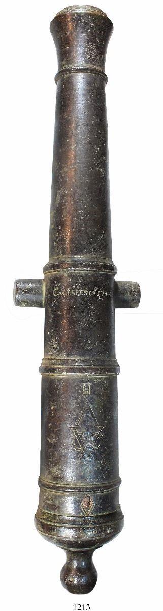
If correct your killing oral and traditional history naming conventions !!While the English just took control of Niew Amsterdam /New York at the time of this document, the whole area was still Dutch, language and customs. A dutch translation of “greate Gunn Hill” as written in the document would be ‘grote kanonheuvel’. So it looks like a direct translation from the Dutch to English.
As to why the name Gun Hill” ? if I had to guess It’s due to the rough geographical shape of the hill . I can imagine back then the view of the hill from a side could look like a cannon. It’s not common for hills and mountains to be named by what they appear to look like. There are many mountains named ‘sugar loaf’. In our area up the Hudson opposite Bear ountain is Anthony’s nose. Traditioun has it named for Anthony DeHooges who along with Adrian Vander Donck were officers of the Dutch patoonship Rensselaerwyck of Kiliaen Van Rensselaer. Looking at the map you can see the long ridge in the form of a cannon. Again good research in making the connection for a new meaning of a familiar local name.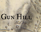

Good Catch TOM ! – I was leaning towards the architect McKelvey and his family as builders many times name building after family members.
Few additional thoughts. I think Nick’s research shows strong proof that it was a cartographer’s error or typo that eventually gave us Mosholu. But there is still the mystery of the meaning of Mosholu or Muscoota. Robert Bolton’s 1848 – ‘smooth stones’, or Grumet’s name of an India Chief. There is also historican Reginal Pelham Bolton, a nephew of Robert once wrote it was derived from the word mosquitoes. But he later wrote it was likely smooth stones.
An East Harlem history site (east-harlem.com) states ” All the area north of what is now 59th Street (on Manhattan) was called “Muscoota” by the Manhattan Indians. Muscoota means “flat place”. This flat place was good for growing food and this is why many of the Manhattan Indians lived in this part of Manhattan.” This actually describes the Van Cortlandt flats and parade grounds pretty well even today.
Search for Munsee words this one comes very close máske·kw (linguistic) máskeekw (practical pronunciation) and (meaning) swamp, pond. A swampy area would also work for today’s TIbbetts brook in today Van Cortlandt park or back in the past, the Muscoota brook.
Given the fact that we will never have a definitive translation or meaning. With nothing written down and native spoken words were generally literal translations written down by Europeans from what they heard spoken. Muscoota might have a few meaning that would describe this area in today’s Van Cortlandt park – ‘flat place” or ‘swampy / pond’ area both seem to describe the area in Van Cortlandt Park and down through the area of old historic Kingsbridge.
-
AuthorPosts